
Abstract
The 1:25,000 geological map of the Entracque–Colle di Tenda area covers an area of about 130 km2 in the Italian Maritime Alps, between the Gesso and Vermenagna valleys. The map area is of great relevance since the Alpine units of this region sampled a geological nodal point in the Mesozoic, at the transition between two different sedimentation domains of the Alpine Tethys European palaeomargin (the Dauphinois basin to the NW and the Provençal platform to the SE). During the Cenozoic, this palaeogeographic hinge was progressively incorporated along multiple shear zone systems developed at the southern termination of the Western Alps arc.
1. Introduction
The 1:25,000 geological map of the Entracque–Colle di Tenda area is the result of 1:10,000 scale surveys performed over the last 10 years at the southern termination of the Western Alps Arc (NW Italy) over an area significantly wider than the one represented here. This document is, thus, the first published detailed map as part of a scientific programme focusing on the revision of the stratigraphic and tectonic setting of a large area encompassing, from NW to SE, the Italian side of the Maritime Alps and the westernmost part of the Ligurian Alps, the main results of which have been recently published (CitationBarale et al., 2013; CitationBertok, Martire, Perotti, d'Atri, & Piana, 2011, Citation2012; Citationd'Atri, Piana, Barale, Bertok, & Martire, submitted; CitationMartire, Bertok, d'Atri, Perotti, & Piana, 2014; CitationPerotti et al., 2012; CitationPiana et al., 2009, Citation2014).
The map area extends from the left side of the Gesso valley (NW) to the Colle di Tenda area (SE) (see Structural Scheme on the Map). It is composed of several tectonic units, separated by NW–SE striking Alpine tectonic contacts. Their geometric position has been classically interpreted to reflect the palaeogeographic position along the Mesozoic European palaeomargin of Tethys; thus, the lowest units were attributed to the more external Dauphinois and Provençal domains, whereas the overlying units to the more internal Subbriançonnais domain (CitationCarraro et al., 1970). On the whole, they presently form a SE–NW trending narrow belt, located between the Argentera Massif to the SW and the more internal Briançonnais and Western Ligurian Helminthoides Flysch units to the NE. However, CitationBarale (2014) and Citationd'Atri et al. (submitted) showed that the stratigraphic succession of the uppermost tectonic unit of our map area (Colle di Tenda unit sensu CitationCarraro et al., 1970; Roaschia unit in this work, see Section 3) has striking similarities with the Provençal ones (see Chapter 4). For this reason, in this paper the Roaschia Unit has been attributed to the Provençal domain, in agreement with CitationMaury and Ricou (1983) who questioned the existence, in the study area, of the Subbriançonnais palaeogeographic domain. In the map area, the transition between the Dauphinois and Provençal domains occurs across palaeoescarpments placed transversely to the contacts between the main tectonic units as, for instance, within the Entracque unit (see Chapter 5).
Since middle Eocene–early Oligocene, the palaeo-European continental margin was progressively involved in the ongoing formation of the Alpine belt. All the studied successions underwent at least three deformation events recorded at the regional scale: a first event with S- and SW-ward brittle–ductile thrusting and superposed folding, a second event with NE-vergent folding, and a third event with southward brittle thrusting and flexural folding (CitationBrizio et al., 1983; CitationPiana et al., 2009). The overall regional kinematic was displayed, at least for the two last deformational stages, in a transpressional regime with important strain partitioning of contractional vs. strike-slip-related structural associations (Citationd'Atri et al., submitted; CitationMolli et al., 2010; CitationPiana et al., 2009), as evidenced by the occurrence of the Limone–Viozene Zone (LiVZ), a post-Oligocene NW–SE Alpine transcurrent shear zone extending for several kilometres from Tanaro valley to the eastern margin of the study area) and of the E–W strike-slip shear zone system generally known as Stura Fault (CitationRicou & Siddans, 1986) and here referred to as the Demonte–Aisone shear zone (DAZ).
The study area was previously mapped in the Demonte sheet of the Geological Map of Italy at 1:100,000 scale (CitationAbiad et al., 1970, explanatory notes by CitationCrema Dal Piaz, Merlo, & Zanella, 1971) and in the Geological Map of the Argentera Massif at 1:50,000 scale (CitationMalaroda, 1970, explanatory notes by CitationCarraro et al., 1970).
The aims of the map are
to represent in detail the lithological and structural features of the stratigraphic successions on the northeastern side of the Argentera Massif;
to characterize and represent the stratigraphic transition between the Dauphinois and Provençal successions;
to identify and map the tectonic structures connecting the LiVZ (occurring to the E of the study area) with the DAZ (occurring to the W); and
to map in detail the carbonate rock bodies affected by dolomitization or recrystallization.
2. Methods
The geological map is drawn at 1:25,000 scale and covers an area of approximately 130 km2. Data were collected through fieldwork at 1:10,000 scale, stored in a geographic information system (GIS) (Coordinate System WGS 1984 UTM, Zone 32N), and represented on a vector topographic map, which for the most part derives from the CTRN (Vector Regional Technical Map) of Piedmont (1:10,000 scale) (see Main Map for further details).
A geological survey of the main lithostratigraphic units has been integrated with observations of mesoscale geological features and by microscale analysis of rocks in thin section (results are fully reported in CitationBarale 2014 and CitationBarale et al. 2013). Orthophoto analysis (2012 AGEA–Agency for Agricultural Supply) was also performed to precisely map the boundaries of Quaternary deposits. A tectonic sketch map at 1:150,000 scale, attached to the map, shows the main tectonic units of the study site and adjoining areas (see also Citationd'Atri et al., submitted). The Permian–Lower Cretaceous units, which had no formal names in the literature, have been labelled referring to toponyms within or adjoining the study area, whereas for the Aptian–Upper Cretaceous succession and the Alpine Foreland Basin succession the names existing in the previous literature have been utilized.
3. Structural setting
The two main macroscale tectonic features of the map area, both NW–SE striking, are the Serra Garb Thrust (SGT) in the northwestern part and the LiVZ in the eastern and southeastern parts (see Structural Scheme in the Main Map).
The SW-vergent SGT caused the superposition of the Roaschia unit, characterized by a Provençal succession, onto the Entracque unit (section A–A’ in the Map) that consists of two distinct stratigraphic successions: Dauphinois in the northwestern sector and Provençal in the southeastern sector. These two sectors are separated by an Early Cretaceous palaeoescarpment (probably active since the Jurassic), partially preserved in the Caire di Porcera locality (see Chapter 5) despite its relative closeness to the multiple shear zones developed in the footwall of the SGT (section B–B’ in the Map).
Just below the SGT, a decametre-wide shear zone is developed, with intense cataclastic deformation and development of drag-fold sequences, kinematically consistent with the SGT sense of shearing. This intensively deformed zone, which reaches a total thickness of 60–70 m, involves almost exclusively the Alpine Foreland Basin successions in the upper part of the Entracque unit, below the SGT.
The Entracque unit footwall is widely deformed by open flexural folds, locally overturned, with poorly inclined axial surfaces (e.g. Monte La Piastra–Monte Lausa anticline). These folds affect both the Jurassic and Cretaceous successions. The asymmetry of the folds indicates that they formed before the SGT shearing, by which they were cut off and partially dragged.
The SGT laterally fringes to the SE into a system of steep strike-slip and convergent-wrench faults that represents the northwestern termination of the LiVZ (CitationPiana et al., 2009), a complex zone where several tectonic slices pertaining to distinct palaeogeographic domains are embedded and mostly sheared along an average WNW–ESE direction (section C–C’ in the Map). The SW-ward tectonic transport of the SGT seems to progressively change (Monte Bussaia area) into the convergent-wrench movements of the southwestern LiVZ boundary faults.
4. Lithostratigraphic units
The stratigraphic succession starts with Permian–Lower Triassic continental to coastal deposits (e.g. CitationBarrier, Montenat, & De Lumley, 2009; CitationFaure-Muret, 1955; CitationMalaroda, 1999), resting on the crystalline basement of the Argentera Massif. They are followed by Middle Triassic peritidal carbonates, Upper Triassic continental red and green shales, Rhaetian–Hettangian peritidal carbonates, and Sinemurian, open-platform bioclastic limestones (CitationCarraro et al., 1970). Starting from the Early–Middle Jurassic, this area differentiated into two distinct sedimentation domains. The Dauphinois domain evolved as a subsident basin, in which thick hemipelagic and pelagic successions were deposited (CitationBarale, 2014), while the Provençal domain remained an area of shallow-water carbonate sedimentation until the earliest Cretaceous (CitationBarale, 2014; CitationBarale et al., 2013). During the Cretaceous, the partial drowning of the Provençal platform led to a relative facies homogenization between the two sectors, in which hemipelagic sediments were deposited (CitationBersezio, Barbieri, & Mozzi, 2002; CitationSturani, 1963), although important thickness differences persisted, related to basin palaeotopography.
In both the Provençal and Dauphinois domains, the top of the Mesozoic succession is truncated by a regional unconformity corresponding to a hiatus spanning the Late Cretaceous–middle Eocene. Above, the Alpine Foreland Basin succession starts with a discontinuous interval of continental to lagoonal deposits (Microcodium Formation), followed by the middle Eocene Nummulitic Limestone ramp deposits, the hemipelagic upper Eocene Globigerina Marl, and the upper Eocene–lower Oligocene turbidite succession of the Gres d'Annot (CitationFord, Lickorish, & Kuznir, 1999; CitationSinclair, 1997).
Some tectonic slices of Western Ligurian Flysch units, deeply involved in the LiVZ (CitationPiana et al., 2014), crop out at the SE edge of the map. They are composed of Cretaceous carbonate-poor, thin-bedded varicoloured pelites (‘basal complexes’ of CitationVanossi et al., 1984) interpreted as basin plain deposits.
4.1. Argentera Massif crystalline basement
The crystalline rocks of the Argentera Massif, cropping out at the western margin of the map and mostly consisting of migmatitic granitoid gneiss with masses of granitoids and migmatitic amphibolites (CitationLombardo, Compagnoni, Ferrando, Radulesco, & Rolland, 2011; CitationMalaroda, 1970), have been represented as a unique cartographic unit, as this map focuses on the sedimentary successions.
4.2. Permian–Lower Jurassic succession
4.2.1. Rocca dell'Abisso Formation (Permian)
Arenites and conglomerates, with minor pelite intercalations. Conglomerates are composed of clasts of volcanic rocks (mainly rhyolites), migmatites, gneiss, quartzites, and granites. This unit is several hundred metres thick, and occurs only in the southern sector of the map (Rocca dell'Abisso, and Vallone del Sabbione). A tectonic slice of volcanic–subvolcanic rhyolitic rocks attributed to the Permian (CitationMalaroda, 1970) occurs close to Colle dell'Arpione.
4.2.2. Valette du Sabion quartzarenites (Early Triassic)
Cross-bedded quartzarenites and pebbly quartzarenites in decimetre-thick beds. This unit is a few metres thick, and locally followed by a few decimetres of dark-red pelites (Vallone del Sabbione, Monte del Chiamossero, and Forte Margheria). In the northern part of the Entracque unit (Vallone d'Alpetto), this unit consists of a few decimetres to a few metres of greenish arenites and siltites, locally cemented by a brown, Fe-bearing carbonate.
4.2.3. Mont Agnelet Formation (Middle Triassic)
Finely crystalline dolostones, dolomitic limestones, and limestones, in decimetre-thick beds, cropping out in tectonic slices of limited extent and thickness (Monte del Chiamossero, Vallone del Sabbione, Gias d'Alpetto, and Colle di Tenda). They show microbial/algal lamination, collapse breccias, and flat-pebble breccias, and contain rare brachiopods and gastropods.
4.2.4. Bec Matlas shales (Late Triassic)
Red and green shales showing a marked slaty cleavage, occurring as metre- to decametre-thick, strongly sheared tectonic slices (e.g. Bec Matlas, Palanfré, and Monte Servatun).
4.2.5. Monte Servatun Formation (Rhaetian–Hettangian)
Fine-grained limestones and dolomitic limestones, with algal lamination, flat-pebble breccias and bivalve-coquina layers, and dark shales with Cardita munita (CitationMalaroda, 1957). This unit crops out only in tectonic slices and, therefore, it is not possible to evaluate its thickness.
4.2.6. Costa Balmera Limestone (Sinemurian)
Bioclastic packstones and wackestones with crinoid ossicles (Pentacrinites? sp.), bivalves, belemnites, and ammonite shell fragments, cropping out in tectonic slices of some hundred metres size. A metre-thick interval of carbonate breccias with clasts of fine-grained dolostones, limestones, and cherts (CitationDomini, 2010), locally cropping out in the southern sector (Punta Bussaia), has been attributed to this unit because of its stratigraphic position, that is, above the Mont Agnolet Formation.
4.3. Middle Jurassic–Lower Cretaceous Dauphinois succession (Barale, 2014)
4.3.1. Entracque Marl (Middle? Jurassic–Berriasian?; Barale, 2014)
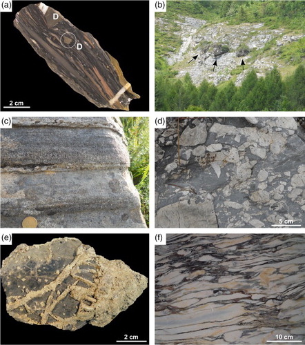
Dark marls, calcareous marls, and shales, in decimetre-thick beds, with rare bioclastic mudstones and wackestones. In the upper part centimetre- to decimetre-thick breccia beds are present, more and more abundant towards the top of the unit. Breccia clasts, millimetre to centimetre sized, are both extraformational (finely crystalline dolostones, ooidal–peloidal grainstones, bioclastic wackestones) and intraformational (greyish and pinkish mudstones) ((a)). This unit is estimated to be some hundred metres thick.
Figure 1. (a) Breccia from the upper interval of the Entracque Marl, with angular clasts of finely crystalline dolostones (D) and stretched mudstone clasts. Punta Stramondin. (b) Metre-sized blocks of dolomitized Garbella Limestone (arrows) in the lower interval of the Lausa Limestone. Tetti Prer. (c) Lithoarenite beds, with erosional base and normal gradation, in the siliciclastic lithozone of Puriac Limestone. Monte La Piastra. (d) Conglomerate with clasts of dolomitized Garbella Limestone, in the basal interval of the Nummulitic Limestone. Monte Garbella. (e) Sample of dolomitized Garbella Limestone, showing the transition from a completely dolomitized portion (right) to a partially dolomitized one (left), with dolomite veins and scattered euhedral dolomite crystals. Monte Colombo. (f) Valdieri Marbles: impure marble formed at the expense of the Puriac Limestone, composed of light-coloured, carbonate-rich domains separated by dark-coloured, silicate-rich layers. Valle Desertetto quarries.
4.3.2. Lausa Limestone (Valanginian? –early Aptian?; Barale, 2014)
Fine-grained limestones, with abundant decimetre-thick beds of polymictic breccias, generally clast-supported, with millimetre- to decimetre-sized clasts of mudstones, coarsely crystalline dolostones (dolomitized Garbella Limestone), and finely crystalline dolostones (Mont Agnolet Formation). Locally (Tetti Prer, Colletta Soprana, and San Lorenzo), metre-sized blocks of dolomitized Garbella Limestone occur ((b)). They are followed by grey mudstones and crinoid-rich wackestones, in centimetre- to decimetre-thick beds, with abundant silicified portions. This unit has a total thickness of 60–70 m.
4.4. Middle Jurassic–Lower Cretaceous Provençal succession
4.4.1. Garbella Limestone (Middle? Jurassic–Berriasian?; Barale, 2014)
Massive limestone succession, 200–300 m thick, mainly composed of bioclastic packstones to rudstones and coral boundstones, containing corals, nerineid gastropods (e.g. Ptygmatis pseudobruntrutana), rudists (Diceratidae), stromatoporoids, and benthic foraminifera (Textularidae and Valvulinidae). In the upper part, mudstones –wackestones – rich in Clypeina jurassica are common. In the Roaschia unit, the earlier described lithofacies are limited to the uppermost some tens of metres, whereas the lower part consists of bioclastic wackestones to packstones or floatstones, with abundant crinoid ossicles, along with rare gastropods, bivalves, corals, stromatoporoids, and red algae. The top of the unit is composed of a metre-thick interval of fenestral and laminated mudstones, associated with flat-pebble breccias, oolitic grainstones, and nodular mudstones. Locally (Monte Colombo and Passo di Ciotto Mien), beds of bioclastic wackestones with Porocharaceae (sp. aff. Porochara fusca), ostracods, and gastropods are also present. This unit is locally affected by important phenomena of hydrothermal dolomitization (see Section 6).
4.4.2. Testas Limestone (Hauterivian p.p.? –Barremian?; Barale, 2014)
This condensed succession is discontinuously present above the Garbella Limestone. In the southern part of the Entracque unit it is composed of a few metres of marly limestones with abundant belemnites and echinoderm fragments. In the Roaschia unit it consists of 10–15 m of crinoid-rich wackestones and packstones, locally passing to proper encrinites (Monte Testas). These deposits are bioturbated (Thalassinoides) and contain decimetre-sized silicified nodules, abundant belemnites, planktonic foraminifera (Hedbergella sp.), fragments of large tube worms, and phosphate grains. At the top, a thick conglomerate bed with belemnites, reworked ammonite moulds (Melchiorites sp., Barremites sp.), solitary corals, and phosphatized lithoclasts is present.
4.5. Aptian–Upper Cretaceous succession
4.5.1. Marne Nere (Aptian–Cenomanian; Carraro et al., 1970)
Dark shales and marls with echinoderm fragments. The total thickness is up to 70–80 m in the northwestern part of the Entracque unit, whereas in the other sectors the unit is much less thick (10–20 m) or even locally absent.
4.5.2. Puriac Limestone (Turonian p.p. –Campanian?; Bersezio et al., 2002; Sturani, 1963)
Alternation of limestones (bioclastic mudstones and wackestones) and marly limestones in centimetre- to decimetre-thick beds. It is several hundred metres thick in the northwestern part of the Entracque unit, whereas it does not exceed 100 m of thickness in the Roaschia unit, and is totally absent in the southeastern sector of the map. It is characterized by the occurrence of two detrital lithozones, which have been distinguished in the map.
Siliciclastic lithozone: limestones and marly limestones interbedded with medium to very coarse, locally microconglomeratic lithoarenites and sandy limestones, in centimetre- to decimetre-thick beds with an erosional base and normal grading ((c)). Lithoarenites show plane parallel lamination and, locally, cross-lamination at the top. Grains are composed of mono- and polycrystalline quartz, volcanic rocks, granitoids, and recrystallized carbonate rocks. Locally (lower Comba dell'Infernetto valley) centimetre- to decimetre-thick beds of matrix-supported conglomerates with sandy limestone or lithoarenite matrix occur. Clasts, up to 15 cm in diameter, consist of granitoids, migmatites, rhyolites, and limestones.
Reworked dolomite lithozone: centimetre- to decimetre-thick beds of packstones, containing reworked dolomite grains (deriving from the dolomitized Garbella Limestone), mudstone clasts, and echinoderm fragments. Dolomite occurs as submillimetric, sub-angular crystal fragments and as millimetre- to centimetre-sized dolostone clasts, constituting up to 30–40% of the rock. Beds commonly have an erosional base, and locally show normal grading, plane parallel lamination, and cross-lamination.
4.6. Alpine Foreland Basin succession
4.6.1. Microcodium Formation (Lutetian? –early Bartonian, Varrone & Clari, 2003)
Lenticular bodies of clast-supported conglomerates, reaching a maximum thickness of 20–25 m (Cima Saben). Clasts are centimetre to decimetre sized, and show a variable composition: limestones and marly limestones, locally encrusted by Microcodium, in the Entracque unit (Caire di Porcera); more or less dolomitized Garbella Limestone in the central part of the Refrey Zone (Passo di Ciotto Mien, Punta Bussaia); and mainly volcanic (rhyolites and dacites) and metamorphic rocks in the Roaschia unit (Cima Saben), in the LiVZ (Bec Baral), and in the eastern part of the Refrey Zone (Colle di Tenda).
4.6.2. Nummulitic Limestone (Bartonian–early Priabonian; Sinclair, 1997)
In the Refrey Zone and in the southern part of the Entracque unit, it is represented by 20–25 m of conglomerates, pebbly sandstones, and sandy limestones with abundant clasts of dolomitized Garbella Limestone, rare quartz grains, and bioclasts (nummulitids, echinoderms, bivalves, gastropods, and red algae) ((d)). In the northern part of the Entracque unit, the Nummulitic Limestone is 5–10 m thick and consists of dark limestones with echinoderm fragments, small nummulitids, and bivalves, whereas in the Roaschia unit and in the LiVZ it consists of 15–20 m of sandy limestones with quartz, mica, lithic clasts, and bioclasts (Nummulites, Dyscocyclina).
At the top of this unit, a thin interval of planktonic foraminifera-rich marls and calcareous marls is locally present (Globigerina Marl Auct.), arranged in centimetre-thick beds and affected by a marked slaty cleavage. The Globigerina Marl, due to the intense tectonic lamination, is laterally discontinuous and its thickness does not exceed a few metres. This unit cannot be represented on a 1:25,000 scale map, and it has been grouped with the Nummulitic Limestone in a unique cartographic unit.
4.6.3. Annot Sandstone (late Priabonian–early Rupelian; Sinclair, 1997)
Alternation of sandstones and dark shales, some hundred metres thick. Sandstone beds are decimetre to metre thick (up to 3–4 metres in the lower part of the succession), and commonly show erosional bases, normal grading, and parallel laminations at the top.
4.7. Western Ligurian Helminthoides Flysch
4.7.1. San Bartolomeo Formation (late Hauterivian–late Campanian; Cobianchi, Di Giulio, Galbiati & Mosna, 1991)
Thin-bedded varicoloured pelites alternating with centimetre-thick carbonate beds (‘basal complexes’ of CitationVanossi et al., 1984), cropping out in the Costa degli Artesin area as decametre- to hectometre-thick sheared tectonic slices involved in the LiVZ.
4.8. Carnieules Auct.
Vacuolar carbonates and polymictic or monomictic breccias with carbonate matrix, commonly occurring as irregular bodies along tectonic contacts, up to several tens of metres large and more than 1 km long. The main masses of carnieules crop out in correspondence with the tectonic boundary between the Argentera basement and the adjoining sedimentary successions (Valle Desertetto, Vallone d'Alpetto, and Vallone del Sabbione). Clast composition is variable and in general reflects the composition of the rocks adjoining the carnieule bodies. Locally (Gias della Culatta) metre-sized blocks are present, composed of green and red pelites, coarsely crystalline gypsum, and fine-grained dolostones. Carnieules can be interpreted as carbonate-cemented tectonic breccias, developed along tectonic contacts at the expense of different rock types.
4.9. Quaternary deposits
Quaternary deposits have been subdivided into three large classes (undifferentiated glacial deposits, undifferentiated alluvial deposits, and slope and talus debris); however, their detailed study is out of scope of this work. For further information, the reader can refer to the map by CitationFederici, Pappalardo, and Ribolini (2003), which covers a large part of the study area and provides an exhaustive representation of Quaternary deposits.
5. The Dauphinois–Provençal boundary
The transition between the Dauphinois basin and the Provençal platform successions occurs at Caire di Porcera, a few kilometres SE of Entracque. This boundary, mapped by CitationMalaroda (1970) and described as a tectonic contact by CitationCarraro et al. (1970), has been recently reinterpreted as a depositional escarpment, separating the top of the drowned Provençal platform from the Dauphinois basin during the Cretaceous (CitationBarale, 2014; Citationd'Atri et al., submitted).
The northern slope of Caire Porcera consists of dolomitized Garbella Limestone, representing the northernmost outcrop of Jurassic Provençal carbonates in the Entracque unit, replaced towards the NW by the Jurassic–Cretaceous Dauphinois succession. It is covered by a few-metres-thick Lower Cretaceous condensed succession, represented by a matrix-supported breccia, laterally equivalent to the lower breccia interval of the Lausa Limestone, followed by belemnite-bearing marly limestones (Testas Limestone, heteropic with the upper interval of the Lausa Limestone). The Cretaceous Marne Nere and Puriac Limestone of the Dauphinois succession progressively thin out towards Caire di Porcera and eventually disappear South of it. Onlap geometric relationships of these units with the condensed Lower Cretaceous succession overlaying the Caire di Porcera northern slope are clearly inferred from map evidence, even if not directly observable.
Even though the direct evidence of the Provençal–Dauphinois transition in Jurassic times cannot be observed, stratigraphic features and map evidence document that this boundary should have been placed close to the earlier described Lower Cretaceous palaeoescarpment.
6. Dolomitization and recrystallization phenomena
The Middle Triassic–Jurassic Provençal carbonates are locally affected by a diffuse hydrothermal dolomitization ((e)). Dolomitization occurred in the Early Cretaceous (probably in the latest Berriasian–Valanginian), at a very shallow burial depth, and was related to the expulsion of hot fluids (about 200°C) through faults and fractures during episodes of fault activity (CitationBarale, 2014; CitationBarale et al., 2013). The distribution of the dolomitized rocks is shown on the map with two different symbols giving a qualitative indication of the dolomitization ‘intensity’, that is, the degree of modification of the primary rock features. In areas with intense dolomitization, host rocks are locally completely dolomitized (metre-sized masses), and both dolomite vein frameworks and dolomite-cemented breccias are present. In areas with moderate dolomitization, rocks are only partially dolomitized, and neither dolomite vein frameworks nor dolomite-cemented breccias are present.
The Mesozoic successions of the Dauphinois and Provencal domains are locally affected by an important recrystallization, accompanied by the growth of new mineral phases, mainly silicates (CitationCarraro et al., 1970) ((f)). The most intense recrystallization affects the Dauphinois succession on the northern side of the Valle Desertetto, in the Entracque unit. Two masses of recrystallized rocks are present, both of kilometre extension, known as Valdieri Marbles. Minor masses of highly recrystallized limestones are present within the Provençal Garbella Limestone, in the southern part of the study area (Vallone del Sabbione). Recrystallization is younger than the previously described dolomitization, because it affects rocks as young as Late Cretaceous (Puriac Limestone). Recrystallization is probably related to a localized upflow of hydrothermal fluids. A regional metamorphism cannot be in fact invoked because of the very local character of recrystallization, which affects discrete rock masses laterally passing into non-recrystallized successions.
Moreover, in a restricted area between Entracque and Valdieri, the Marne Nere and the lower interval of the Puriac Limestone contain abundant crystals of authigenic albite, up to several millimetres long, whose genesis is probably related to a localized fluid circulation (CitationBarale, 2014). The distribution of marble masses and the occurrence of authigenic albite have been indicated in the map.
7. Conclusions
The 1:25,000 geological map of the Entracque–Colle di Tenda area provides a representation of the stratigraphic and structural setting of the Meso–Cenozoic sedimentary successions placed at the northeastern side of the Argentera Massif, and it constitutes a complementary document useful to address some specific issues discussed in papers of recent or forthcoming publications (CitationBarale et al., 2013; Citationd'Atri et al., submitted; CitationPiana et al., 2009, Citation2014), namely
the structural setting of the regional shear zone systems developed at the southern termination of the Western Alps arc;
the nature of the lateral transition between the Dauphinois and Provençal successions; and
the distribution of carbonate rock bodies affected by hydrothermal dolomitization and by recrystallization phenomena.
Software
The compilation of the geological map, including the preparation of the topographic base, was performed using the Esri ArcGIS 9.2. The final layout of the map, the geologic sections, the tectonic sketch map, and the figures were assembled and drawn using ACD Canvas12.
GEOLOGICAL MAP OF THE ENTRACQUE-COLLE DI TENDA AREA (MARITIME ALPS, NW ITALY)
Download PDF (12.6 MB)Acknowledgements
Alessia Musso is acknowledged for sharing field work in the early phases of the research. We would like to thank the Associate Editor Claudio Riccomini, and the Referees Riccardo Bersezio, Silvio T. Hiruma, and Thomas Pingel, whose useful suggestions improved both the manuscript and the geological map.
Disclosure statement
No potential conflict of interest was reported by the authors.
Additional information
Funding
Related Research Data
References
- Abiad, P., Bortolami, G., Cancelmo, C., Carraro, F., Crema, G., Cucchi, F., … Zappi, L. (1970). Carta geologica d'Italia, Foglio 90 Demonte [Geological Map of Italy, sheet 90 Demonte]. Roma: Servizio Geologico Italiano.
- Barale, L. (2014). The Meso-Cenozoic stratigraphic successions adjoining the Argentera Massif: Stratigraphic, sedimentologic and diagenetic evidence of syndepositional tectonics (Unpublished doctoral dissertation). Torino: Università di Torino.
- Barale, L., Bertok, C., d'Atri, A., Domini, G., Martire, L., & Piana, F. (2013). Hydrothermal dolomitization of the carbonate Jurassic succession in the Provençal and Subbriançonnais domains (Maritime Alps, North-Western Italy). Comptes-Rendus Geoscience, 345, 47–53. doi:10.1016/j.crte.2012.10.015
- Barrier, P., Montenat, C., & De Lumley, H. (2009). Empreintes de pas de reptiles au Pic des Merveilles dans le Permien du massif du Mont-Bego (Alpes-Maritimes) [Vertebrate footprints at the Pic des Merveilles from the Permian of the Mont-Bego massif (Alpes–Maritimes, France)]. Comptes Rendus Palevol, 8, 67–78. doi:10.1016/j.crpv.2008.11.001
- Bersezio, R., Barbieri, P., & Mozzi, R. (2002). Redeposited limestones in the Upper Cretaceous succession of the Helvetic Argentera Massif at the Italy–France border. Eclogae Geologicae Helvetiae, 95, 15–30. doi:10.5169/seals-168943
- Bertok, C., Martire, L., Perotti, E., d'Atri, A., & Piana, F. (2011). Middle–Late Jurassic syndepositional tectonics recorded in the Ligurian Briançonnais succession (Marguareis–Mongioie area, Ligurian Alps, NW Italy). Swiss Journal of Geosciences, 104, 237–255. doi: 10.1007/s00015-011-0058-0
- Bertok, C., Martire, L., Perotti, E., d'Atri, A., & Piana, F. (2012). Kilometre-scale palaeoescarpments as evidence for Cretaceous synsedimentary tectonics in the external Briançonnais domain (Ligurian Alps, Italy). Sedimentary Geology, 251, 58–75. doi:10.1016/j.sedgeo.2012.01.012
- Brizio, F. D., Deregibus, C., Eusebio, A., Gallo, M., Gosso, G., Rattalino, E., … Oxilia, M. (1983). Guida all'escursione: i rapporti tra la zona Brianzonese Ligure e il Flysch a Elmintoidi, Massiccio del Marguareis. (Limone Piemonte-Certosa di Pesio, Cuneo, 14/15 Settembre 1983) [Field trip guide: Relationships between the Ligurian Briançonnais Zone and the Helminthoides Flysch, Marguareis Massif. (Limone Piemonte-Certosa di Pesio, Cuneo, September 14/15th, 1983)]. Memorie della Società Geologica Italiana, 26, 579–595.
- Carraro, F., Dal Piaz, G. V., Franceschetti, B., Malaroda, R., Sturani, C., & Zanella, E. (1970). Note illustrative della Carta Geologica del Massiccio dell'Argentera alla scala 1:50.000 [Explanatory notes of the Geological Map of the Argentera Massif at 1:50,000]. Memorie della Società Geologica Italiana, 9, 557–663.
- Cobianchi, M., Di Giulio, A., Galbiati, B., & Mosna, S. (1991). Basal complex of S. Remo Flysch in the S. Bartolomeo area, Western Liguria (preliminary note). Atti Ticinensi di Scienze della Terra, 34, 145–154.
- Crema, G., Dal Piaz, G. V., Merlo, C., & Zanella, E. (1971). Note illustrative della Carta Geologica d'Italia alla scala 1:100.000, Fogli 78–79–90, Argentera–Dronero–Demonte [Explanatory notes of the Geological Map of Italy at 1:100,000, sheets 78–79–90, Argentera–Dronero–Demonte]. Roma: Servizio Geologico Italiano.
- d'Atri, A., Piana, F., Barale, L., Bertok, C., & Martire, L. Geological setting of the southern termination of Western Alps arc. International Journal of Earth Sciences. Manuscript submitted for publication.
- Domini, G. (2010). Geological mapping and stratigraphical and structural analysis of the high Vermenagna Valley left side (Colle di Tenda – Maritime Alps) (Unpublished master's thesis). Torino: Università di Torino.
- Faure-Muret, A. (1955). Etudes géologiques sur le massif de l'Argentera–Mercantour et ses enveloppes sédimentaires [Geological study on the Argentera Massif and its sedimentary covers]. Paris: Mém. Carte Géol. France.
- Federici, P. R., Pappalardo, M., & Ribolini, A. (2003). Geomorphological map of the ‘Maritime Alps’ Natural Park and surroundings (Argentera Massif, Italy). Firenze: S.EL.CA.
- Ford, M., Lickorish, W. H., & Kuznir, N. J. (1999). Tertiary Foreland sedimentation in the Southern Subalpine Chains, SE France: A geodynamics appraisal. Basin Research, 11, 315–336. doi: 10.1046/j.1365-2117.1999.00103.x
- Lombardo, B., Compagnoni, R., Ferrando, S., Radulesco, N., & Rolland, Y. (2011). Varisican geology of the Argentera Massif, Western Alps and comparison with the Maures–Tanneron Massif (France). Annales du Muséum d'Histoire naturelle de Nice, 26, 139–163.
- Malaroda, R. (1957). Studi geologici sulla dorsale montuosa compresa tra le basse Valli della Stura di Demonte e del Gesso (Alpi Marittime) [Geological study on the mountain range between the lower Stura di Demonte and Gesso valleys (Maritime Alps)]. Memorie Istituto Geologia e Mineralogia Università di Padova, 20, 1–130.
- Malaroda, R. (Ed.). (1970). Carta Geologica del Massiccio dell'Argentera alla scala 1:50.000 [Geological Map of the Argentera Massif at 1:50,000]. Memorie della Società Geologica Italiana, 9.
- Malaroda, R. (1999). L'Argentera meridionale – Memoria illustrativa della ‘Geological Map of Southern Argentera Massif (Maritime Alps) 1:25 000’ [The Southern Argentera – explanatory note of the ‘Geological Map of Southern Argentera Massif (Maritime Alps) 1:25 000’]. Memorie di Scienze Geologiche, 51–52, 241–331.
- Martire, L. Bertok, C., d'Atri, A., Perotti, E., & Piana, F. (2014). Selective dolomitization by syntaxial overgrowth around detrital dolomite nuclei: A case from the Jurassic of the Ligurian Briançonnais (Ligurian Alps). Journal of Sedimentary Research, 84, 40–50. doi:10.2110/jsr.2014.2
- Maury, P., & Ricou, L. E. (1983). Le décrochement subbriançonnais: une nouvelle interprétation de la limite interne-externe des Alpes franco-italiennes [The Subbriançonnais strike-slip fault system: A new interpretation of the internal–external boundary of the French–Italian Alps]. Revue de Géologie Dynamique et de Géographie Physique, 24, 3–22.
- Molli, G., Crispini, L., Malusà, M. G., Mosca, P., Piana, F., & Federico, L. (2010). Geology of the Western Alps–Northern Apennine junction area: A regional review. In M. Beltrando, A. Peccerillo, M. Mattei, S. Conticelli, & C. Doglioni (Eds.), The geology of Italy: Tectonics and life along plate margins. Journal of the Virtual Explorer, 36, 10. doi:10.3809/jvirtex.2010.00215
- Perotti, E., Bertok, C., d'Atri, A., Martire, L., Piana, F., & Catanzariti, R. (2012). A tectonically-induced Eocene sedimentary mélange in the West Ligurian Alps, Italy. Tectonophysics, 568–569, 200–214. doi:10.1016/j.tecto.2011.09.005
- Piana, F., Battaglia, S., Bertok, C., d'Atri, A., Ellero, A., Leoni, L., … Perotti, E. (2014). Illite (KI) and chlorite (AI) ‘crystallinity’ indices as a constraint for the evolution of the external Briançonnais front in Western Ligurian Alps (NW Italy). Italian Journal of Geosciences, 133 (3), 445–454. doi:10.3301/IJG.2014.21
- Piana, F., Musso, A., Bertok, C., d'Atri, A., Martire, L., Perotti, E., … Martinotti, G. (2009). New data on post-Eocene tectonic evolution of the external Ligurian Briançonnais (Western Ligurian Alps). Italian Journal of Geosciences, 128, 353–366. doi:10.3301/IJG.2009.128.2.353
- Ricou, L. E. & Siddans, A. W. B. (1986). Collision tectonics in the Western Alps. Geological Society London Special Publications, 19, 229–244. doi:10.1144/GSL.SP.1986.019.01.13
- Sinclair, H. D. (1997). Tectonostratigraphic model for underfilled peripheral foreland basins: An Alpine perspective. GSA Bulletin, 109, 324–346. doi: 10.1130/0016-7606(1997)109<0324:TMFUPF>2.3.CO;2
- Sturani, C. (1963). La couverture sédimentaire de l'Argentera–Mercantour dans le secteur compris entre les Barricate et Vinadio (haute vallée de la Stura di Demonte, Italie) [The sedimentary cover of the Argentera–Mercantour in the sector between Barricate and Vinadio (upper Stura di Demonte Valley, Italy)]. Travaux du Laboratoire de Géologie de Grenoble, 39, 83–124.
- Vanossi, M., Cortesogno, L., Galbiati, B., Messiga, B., Piccardo, G., & Vannucci, E. (1984). Geologia delle Alpi liguri: dati, problemi, ipotesi [Geology of the Ligurian Alps: Data, problems, hyoptheses]. Memorie della Società Geologica Italiana, 28, 5–75.
- Varrone, D., & Clari, P. (2003). Stratigraphic and paleoenvironmental evolution of the Microcodium Formation and the Nummulitic Limestones in the French-Italian Maritimes Alps. Geobios, 36, 775–786. doi: 10.1016/j.geobios.2003.09.001