
Abstract
A detailed geological survey of the Southern slope of Turin Hill reveals a Pleistocene terraced fluvial succession consisting of flat surfaces separated by scarps with associated fluvial clayey–silty and gravelly sediments. This succession is not linked to the present N–S hilly streams, but is instead related to major Pleistocene W–E rivers. The collected regional data suggest an ancient trend of the Po River flowing across Turin Hill, prior to its present course to the north of the hill. The Pleistocene terraced fluvial succession of the Western slope of Turin Hill is also mapped, based on a previous survey to allow a full reconstruction of the ancient rivers. The collected regional data and the petrographic analysis show that this succession is related to an ancient tributary of the Po River (Dora Riparia River). Wide saddles of the same river have been mapped on the main watershed between the two slopes of Turin Hill. The capping of soils less evolved with decreasing elevation over the fluvial sediments and landforms indicates that the whole terraced succession covers a large time range (Middle–Upper Pleistocene). The reported geologic successions and the current morphology of the relief result from the uplift and deformation of the Pleistocene Po Plain and the Dora Riparia Plain that were shaped at the south of Turin Hill. The proposed age/elevation relationships for the mapped terraces suggest a remarkable uplift of Turin Hill during the late Quaternary.
Keywords:
1. Introduction and previous work
The remains of Pleistocene fluvial landforms and sediments on the slopes of Turin Hill (the Western portion of the North-Apennines chain) have been observed and reported over the last few years. Specifically, the fluvial terraced successions on the Western, NorthWestern and Northern slopes have been widely mapped and described (CitationBarbero, Boano, Colla, & Forno, 2007; CitationForno et al., 2002; CitationForno & Lucchesi, 2005) and heavy mineral analysis of the fluvial sediments, on the Western and NorthWestern slopes, has demonstrated a link with ancient trends of the Dora Riparia River and the Stura di Lanzo River (CitationVezzoli et al., 2009). The Dora Riparia River had a southward trend in the Middle Pleistocene and shifted through time to a northward trend in the Upper Pleistocene (see sketch 1 on the Main Map).
The location of these successions and their relationship to an ancient hydrographic network with a very different trend from the present one also suggest a lower relief than the present one. These features, therefore, testify to a remarkable Quaternary tectonic deformation in this area (CitationBoano, Forno, & Lucchesi, 2004). A subsequent reconstruction of the recent deformation of Turin Hill derived from the study of the migration of tributary streams indicates a gradual adjustment of the hydrographic network to the tectonic uplift of the area (CitationForno & Boano, 2006).
The fluvial sequence on the Southern slope of Turin Hill, however, has only been roughly mapped and briefly described on geological maps 157 ‘Trino’ and 156 ‘Torino Est’ of the Geological Map of Italy at a scale 1:50,000 (CitationDela Pierre, Piana, Boano, et al., 2003; CitationDela Pierre, Piana, Fioraso, et al., 2003; CitationFesta, Boano et al., 2009; CitationFesta, Dela Pierre, et al., 2009; CitationForno, Fioraso, & Boano, 2008) and was later reported in a field trip guidebook for Turin Hill (CitationCarraro, Forno, Giardino, & Paro, 2005). The only detailed research regarding the Pleistocene fluvial succession for this slope is focused on the petrographic composition of locally outcropping gravelly deposits (CitationCompagnoni & Forno, 1992). In detail, the composition of the gravels allowed the identification of the catchment basin of the Po River as a tributary draining the Lanzo Ultramaphic Massif (Sangone, Dora Riparia or Stura di Lanzo rivers). The provenance from this basin is evidenced by the overall composition and by some peridotite clasts of the Lanzo Ultramaphic Massif (CitationCompagnoni & Forno, 1992).
Because detailed mapping of the Southern slope of Turin Hill is missing, the goal of the present study is to complete the cartography of the fluvial succession for the entire hilly area. This contribution is necessary for a full reconstruction of the Quaternary evolution of Turin Hill and, more generally, the analysis of tectonic activity of the Apennine edge in NorthWestern Italy.
2. Morphological and geological setting
Turin Hill is a Southwest–Northeast (SW–NE) elongated ridge rising to an altitude of 715 m a.s.l., located in the central side of the Po Plain. It is highly perched on the plain (approximately 500 m), consisting of the Turin Po Plain to the north and to the west (with an elevation of 190–220 m a.s.l.) and the Poirino Plateau to the south (with an elevation of 240–280 m a.s.l.).
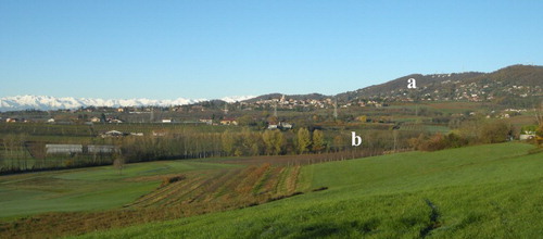
The morphology of the relief is remarkably asymmetric as evidenced by the presence of a relatively steep (10–15%) West–Northwest (W–NW) slope and a much less inclined (5–10%) Southern slope (). In detail, the lower side of the Southern slope (between 240 and 350 m a.s.l.) shows a very flat morphology, essentially preserving most of the features of the original plain (see sketch 2 on the Main Map). The current hydrographic networks developed on the two slopes are variously entrenched; they mainly flow to the NW in the Western and NorthWestern slope and to the South-southeast (SSE) on the Southern slope.
Figure 1. Different morphologies of the Southern slope of the Turin Hill high sector (a, steeper) and the low sector (b, very flat), observed from the San Felice Church (Unit 6s).
Turin Hill consists of a marine succession spanning from the Upper Eocene and the Pliocene in age (CitationBortolami et al., 1969) (). This Tertiary sequence lies on the Alpine metamorphic bedrock (CitationCastellarin, 1994; CitationGelati & Gnaccolini, 1988) and, according to the most recent studies, on a Southalpine metamorphic bedrock (CitationMosca, 2006). Above the marine sediments of the bedrock, a discontinuous cover of incoherent silty sediments is well described and related to the Upper Pleistocene aeolian loess cover (CitationBortolami et al., 1969; CitationForno, 1990). In contrast, the presence of fluvial sedimentary bodies interposed between the Tertiary marine succession and the Upper Pleistocene loess cover is found only on the Northern (CitationBarbero et al., 2007; CitationDela Pierre, Piana, Boano, et al., 2003; CitationDela Pierre, Piana, Fioraso, et al., 2003) and Western and SouthWestern slopes (CitationBoano et al., 2004; CitationFesta, Boano, et al., 2009; CitationFesta, Dela Pierre, et al., 2009; CitationForno & Lucchesi, 2005); however, the fluvial succession of the Southern slope has never been described or mapped.
Figure 2. Structural model of the Piedmont hilly sector; the dotted square represents the study area (modified from CitationDela Pierre, Piana, Boano et al., 2003).
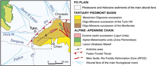
The whole sedimentary succession of Turin Hill is variously deformed, forming an asymmetrical anticline with a SW–NE-oriented axis. This NW verging structure overthrusts onto the Po Plain foredeep towards the NW along the Padan Frontal Thrust currently buried by the Quaternary fluvial sediments of the Po Plain (CitationCastellarin, 1994; CitationFesta, Boano, et al., 2009) (). The succession is also bound to the East by the ‘Rio Freddo Deformation Zone’ a left transpressive shear zone dividing Turin Hill from the Monferrato Reliefs (CitationPiana & Polino, 1995) ().
The described asymmetric morphology of the relief is essentially due to both asymmetric anticline deformation of Turin Hill and the buried thrusts belt that bounds the NorthWestern slope of the hill towards the Po Plain (CitationMosca, Polino, Rogledi, & Rossi, 2010). The entire sedimentary succession of Turin Hill comprising the Pleistocene sediments is involved in the deformation. This evidence suggests that tectonic activity affected the succession almost between the late Neogene and the Upper Pleistocene (CitationBoano et al., 2004). The recent tectonic activity observed in the study area is in accordance with the strong uplift observed at the North-Apennines foothills along the Padan Frontal Thrust (CitationBenedetti, Tapponnier, Gaudemer, & Manighetti, 2003; CitationBoccaletti et al., 1985; CitationBurrato, Ciucci, & Valensise, 2003; CitationCastellarin et al., 1985; CitationMutti et al., 1995).
3. Methods
A detailed geological and geomorphological field survey and a traditional and digital analysis of hard copy and digital aerial photos were carried out, in order to map the Quaternary fluvial landforms and sediments. The distribution of the fluvial succession and landforms was mapped on the Carta Tecnica della Regione Piemonte of the Regional Agency for the Protection of the Environment (A.R.P.A. Piemonte), first at a scale of 1:10,000, and then simplified at 1:20,000 scale in the final document. Map design and database construction were carried out using Esri ArcGIS 9.3. The final graphical elaboration of the map was realized using Adobe Illustrator CS2.
The Quaternary fluvial succession has been subdivided into different units on the basis of allostratigraphic, morphostratigraphic and pedostratigraphic criteria. In detail, the different units were defined according to the morphology of the terraces (lateral continuity, elevation and morphology), the sedimentary facies of associated deposits and the degree of soil development. A detailed description of the fluvial terraces and the criteria used for their morphological analysis was reported in CitationForno and Lucchesi (2005).
The main difficulties regarding the mapping of the fluvial sediments were due to the lack of wide outcrops, and the large distribution of aeolian loess and colluvial deposits, both covering the fluvial succession. In addition, during the field surveys some local man-made modifications of the original morphology, related to the recent urban expansion, were detected. As previously indicated for the NorthWestern slope of Turin Hill (CitationBoano et al., 2004), these modifications have mostly enhanced the natural flat morphology of some fluvial terraces.
4. The geological map
The Pleistocene succession of the Southern slope of Turin Hill (extending approximately 70 km2) has been represented on the geological map (see the Main Map). The Pleistocene succession of the Western slope of the hill (a focus of CitationForno & Lucchesi, 2005) has also been reported to allow a correlation between the fluvial successions of the two areas and a full reconstruction of the ancient rivers.
The fluvial remains (landforms and sediments) with different altitude distribution and different soils have been distinguished in units of various ages, presented as different colours. The information regarding the presence or absence of deposits and the occurrence of soils has been reported with different symbols (colours for sediments, horizontal stripes for surfaces without sediments and vertical stripes for surfaces without sediments but with soils).
A reconstruction of the original distribution of the different units has been mapped in pale colours, considering the distribution of the fluvial terraces associated with each unit and their geometric and stratigraphic location. This interpolation together with the whole geological context shows that the rivers shaping the fluvial succession had a meandering trend. Sometimes the original distribution of the different units had been cut both by the more recent configurations of the main river and, afterwards, by the local tributary streams. The saddles on the slope show where the trend of a previous hydrographic network has been cut by a younger one. The terraced surfaces have been numbered starting from the more recent units (from 5 to 16), as reported for the Western–NorthWestern slope (CitationForno & Lucchesi, 2005). The lower units (from 1 to 4) are not distributed on the hilly slope but are preserved in the Poirino Plateau, located immediately to the south of the study area. The topographic map (1:10,000 scale) of the Regional Agency for the Protection of the Environment (A.R.P.A. Piemonte, edition 1991–2005) has been used as a base map, as it is the most detailed map of the area.
5. The fluvial succession of the Southern slope
The Southern slope, although shaped in the Tertiary marine sediments, shows a diffuse cover of Pleistocene sediments, which are not yet mapped in detail, along with associated typical landforms. This slope shows numerous secondary ridges oriented approximately North-northwest (NNW)–SSE, due to the incision of the present hilly valleys, which also have a NNW–SSE trend. From west to east the low elongated ridges of Moncalieri, Villa Fossati, Villa Maggi, Madonna del Rocciamelone, Cascina Proglio, Revigliasco, Sauglio, Pecetto, Cascina Albera, Tetti Rosero, San Felice, Tetti Finetta, Villa Luigina and Chieri are recognized (). The summits of these secondary ridges have a similar altitude profile with typical morphologies. They have an overall slope towards the South (5–10%), and they show many very slightly inclined sectors of various sizes (between about 100 and 500,000 m2), separated by narrow steep sectors and wide counter-slope depressions (see sketch 2 in the Main Map). The morphology of these summits, therefore, preserves a series of flat surfaces (), scarps and counter-slope depressions, as locally observed in Units 14 and 11 reported in the Main Map.
Figure 3. The ridges of the Southern and Western slopes of the Turin Hill.
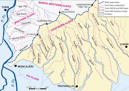
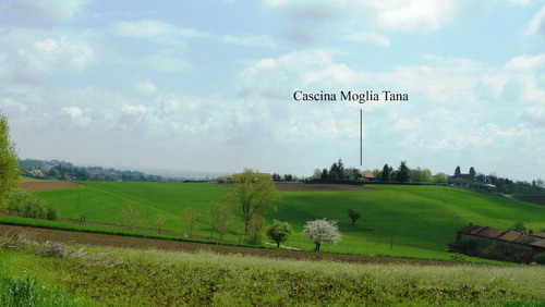
Figure 4. Wide terraced surface (Unit 7s) of Cascina Moglia di Tana observed from Castelverde.
The individual flat sectors have a NNW–SSE orientation. Joining together the flat sectors, preserved on the different ridges, at the same range of altitudes and with the same pedological and morphological features, we obtained numerous strips elongated in a W–E direction and separated by narrow scarps. These strips (mapped with different pale colours in the Main Map) represent the relicts of the wide ancient valley floor and its alluvial fill.
The present southward sloping of the surfaces, as shown in the NNW–SSE cross-section (sketch 2 in the Main Map), is mainly due to the southward tectonic tilting of the Southern slope of Turin Hill.
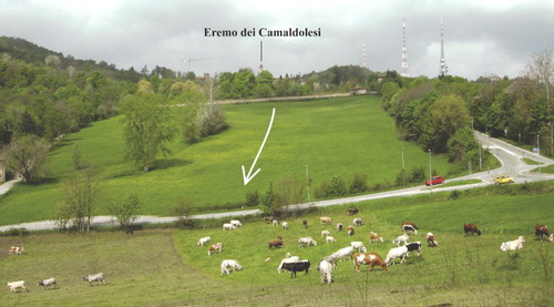
Evidence is also present on the main watershed between the Southern and the Western–Nothwestern slopes, partly corresponding to the Moncalieri ridge (). It preserves some wide depressions that form saddles (), which are particularly remarkable for their large dimensions (∼100 m) and for their high location on the watershed that makes them visible from great distances, resulting in the profile of the hill (see ).
Figure 5. Saddle of Eremo in the watershed and abandoned valley (arrow) (Unit 14w), shaped by an ancient Dora Riparia River, a tributary of the ancient Po River.
A set of elements allows the interpretation of these landforms as fluvial terraced surfaces:
the flat morphology separated by scarps, typical of fluvial terraced surfaces;
the local preservation of arched depressions corresponding to remains of meanders;
the presence of clayey–silty or gravel sediments, likely deposited on bedrock by a river.
The preservation of ancient fluvial morphology only on the summit of the secondary ridges, and not on the overall slope, is due to the subsequent erosion by the present hilly streams.
The distribution of this succession is relatively homogeneous considering that the different NNW–SSE elongated ridges preserve approximately the same number of terraced surfaces (up to 12 units between Unit 16s and Unit 5s). Their morphology, with the top weakly inclined towards the SSE, along with the presence of sediments that appear progressively less weathered from north to south, suggests that these surfaces form a succession of stratigraphic units that are progressively more recent towards the plain (to the SSE). In detail, most of the described terraced surfaces lie on the summits of the main ridges, forming a terraced succession degrading towards the plain. Locally, some surfaces are entrenched on the slope, preserved within counter-slope depressions and located around some isolated relief cut in the bedrock.
Although numerous small fluvial terraces are also visible entrenched in the current valleys, only the terraces preserved on the summit of the NNW–SSE elongated ridges are mapped because they are the only ones connected to the ancient fluvial modelling, as documented by the alluvial deposits. Therefore, they are significant for the reconstruction of the progressive trend of the main ancient rivers that shaped the Southern slope. In contrast, the fluvial terraces entrenched into the valley, which are linked to the current hilly streams, are, instead, only significant for the reconstruction of the tributary network. The latter surfaces have been the subject of specific research regarding the gradual adjustment of the hydrographic network to the tectonic deformation of the area (CitationForno & Boano, 2006). Some NW–Southeast (SE) saddles are also reported on the elongated ridges, and they can be considered to be connected to the subsequent incision by ancient tributaries (see the Main Map).
Taking into account all the flat surfaces preserved on the summit of the NNW–SSE ridges, the 12 fluvial units are preserved in a 450 m altitude range (between 715 and 260 m a.s.l.). The fluvial terraces set in the upper sector of the slope predominantly preserve the original fluvial cover, between 1 and 5 metres thick, but some of these are without sediments and are currently shaped in the Tertiary marine succession exclusively preserving soils with varying degrees of evolution. Local erosion of the fluvial sediments is coupled by a strong remodelling of the terraces. In contrast, the fluvial terraces in the lower sector always preserve the fluvial sediments, which are between 1 and 10 metres thick, indicating the prevailing conservation of the primary features.
Based upon the different terrace morphologies and the preservation of fluvial sediments, we can distinguish a relatively steeper upper range (from 715 to 360 m a.s.l.), in which a succession of small and discontinuous terrace relicts is recognizable (Unit 16s to 7s) and a less inclined lower range (from 350 to 280 m) that preserves the relics of wider and more continuous terraces (Units 6 and 5). The correlation of the various relicts of the same terrace is more uncertain in the upper sector as a consequence of the more intense remodelling; in contrast, the correlation in the lower range is evident. The widest and best preserved terrace is located in the altitude range of approximately 350–280 m (), along the San Felice ridge (Unit 6s). The lower terrace (Unit 5s) can be correlated with the wide terraced surface of the Poirino Plateau.
The fluvial sediments forming the different terraces fill elongated depressions shaped in the Tertiary bedrock that are now buried by fluvial sediments (). They are mostly clayey–silty deposits without stratification or other sedimentary structures and show only a prismatic cracking related to soil-forming processes (). They have a high clay content (about 50%), high silt content (about 40–45%) and a small sand content (about 5–10%).
Figure 6. Under the colluvial cover (A) outcrops the Pleistocene fluvial clayey–silty sediments (B) (Unit 7s) filling a wide depression shaped in the Tertiary marine marly sediments (C) (Pecetto Torinese 500 m S of Cascina Albera).
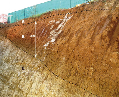
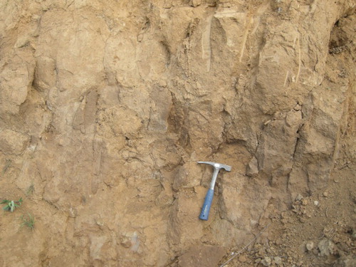
Figure 7. Clayey–silty sediments diffusely outcropping (Unit 8s near Cascina Long). They show a prismatic cracking and a reddish-brown colour.
Locally, gravelly sediments outcrop below the clayey–silty sediments (), showing a clast-supported structure, with a scanty clayey–silty–sandy matrix. These sediments are formed by centimetric to decimetric clasts (between 5 and 30 cm) with low sphericities and high rounding; they are imbricated and show a concave cross-bedding and normal gradation. The prevalently elongated clasts consist of serpentinite (predominant), prasinite, gabbro and metagabbro (very abundant), eclogite (abundant), peridotite, metabasite s.l. and quartzite (scanty), rodingite and metabasalt (very scanty) (CitationCompagnoni & Forno, 1992).
Figure 8. Fluvial cross-bedded gravel (Unit 6s) locally outcropping over the Piacenzian deltaic sand (Trofarello near Sauglio).
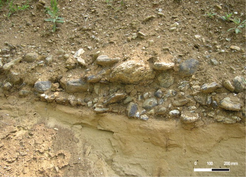
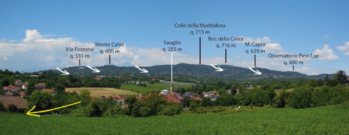
Figure 9. In the low sector of the Southern slope of the Turin Hill, an ancient trend of the Po River is preserved (yellow arrow). The numerous saddles on the main watershed are instead linked to the shaping by ancient trends of the Dora Riparia River (white arrows).
The sediments show different features at different altitudes, due particularly to differences in weathering. The higher terraces have very evolved soils, clay texture, very thick clay skins, a red colour () (between 2.5 and 5 YR Munsell Soil Color Charts) and a strong cementation by iron oxides. In contrast, the lower terraces show sediments characterized by slightly evolved soils with a prevailing silty–sandy texture, thin clay skins, a yellowish–brown colour (7.5 YR Munsell Soil Color Charts) and a soft consistency.
The fluvial sediments are covered by a continuous body of loess, with a maximum thickness of 6 m. They are widespread in the Western sector of the slope, between the Moncalieri and the Tetti Rosero ridges (). The loess cover preserves the underlying fluvial sediments, but often prevents their observation. Locally, a more recent cover of aeolian sands, with a maximum thickness of 8 m, further hides the fluvial bodies. Aeolian sediments, which have been described in previous studies (CitationForno, 1990), are not represented on the geological map which is devoted to the mapping of the fluvial succession.
6. Discussion
The morphology of the Southern slope of Turin Hill is typical for the presence of numerous flat surfaces preserved on the NNW–SSE secondary ridges. In detail, the Southern slope preserves the terraced succession of an ancient trend of the Po River, flowing on the Southern slope of Turin Hill towards the East (). This reconstruction is proven by the following evidence:
The composition of fluvial gravel preserved on the Southern slope, which is associated with the terraced succession, indicates a supply by the Po Basin with a tributary in the Lanzo Ultramafic Massif (Sangone, Dora Riparia or Stura di Lanzo rivers) (CitationCompagnoni & Forno, 1992).
The reconstruction of the rivers of the Middle and Upper Pleistocene in the central Piedmont suggests the absence of the Po River along the Northern edge of Turin Hill, where the Po River is currently draining (CitationCarraro et al., 1995).
At this time, the Po River flowed through a plain that subsequently became the present Southern slope of Turin Hill (see sketch 1 on the Main Map). It can be assumed that this river had a large tributary (the Dora Riparia River draining from north to south), as evidenced by the terraced succession preserved on the Western slope (). In detail, the mineralogical data regarding these fluvial successions are in agreement with the shaping by the Dora Riparia River (CitationForno & Lucchesi, 2005; CitationVezzoli et al., 2009), to form a tributary of the ancient Po River on the Southern slope. The fluvial saddles preserved on the main watershed between the Southern and the Northwest–Western slopes are most likely also connected to ancient trends of the Dora Riparia River, indicating that this ancient river has repeatedly crossed Turin Hill.
The very different degree of weathering of the sediments in the various terrace orders indicates that the rivers developed over a large time scale likely between the Middle Pleistocene and the Upper Pleistocene (CitationArduino, Barberis, Carraro, & Forno, 1984). The large number of terraced surfaces separated by narrow scarps is connected to the lateral migration and downcutting of the ancient river. The features of the fluvial succession, which prevalently degrade toward the south, suggest a gradual southward shifting of the rivers between the watershed of the hill and the plain. The local presence of isolated relief, which emerges from the fluvial succession, suggests a connection with slightly entrenched rivers with occasionally more articulated W trends, before southward slide.
Most of the units are characterized by the presence of the fluvial sediments. Only some of the upper surfaces (Unit 16s and Unit 15s) are modelled in the bedrock, indicating subsequent strong erosion.
Presently, the distribution of the ancient fluvial succession is discontinuous because it was cut by the torrential valleys connected to the present hilly streams. This cutting is consequent to the gradual uplift of the relief, which is significant in the watershed and diminishes towards the plain. The local presence of NW–SE saddles on the elongated ridges shows that the fluvial terraced succession was affected by the erosion of some ancient tributaries of the ancient main meandering river (as observed in Unit 6s near Cascina Proglio).
The occurrence of similar strong uplift is indicated in other hilly sectors of the Apennine edge, along the Padan Frontal Thrust, where fluvial successions analogous to the one observed on Turin Hill are reported (CitationBenedetti et al., 2003; CitationBoano et al., 2004; CitationBruno, Pazzaglia, & Picotti, 2011; CitationBurrato et al., 2003; CitationGunderson et al., 2014; CitationPicotti & Pazzaglia, 2008; CitationPonza, Pazzaglia, & Picotti, 2010).
7. Conclusions
The described fluvial terraced succession is the result of the uplift and deformation of the original Po Plain before the Po River displacement to the north of Turin Hill (Main Map). The estimated ages of fluvial terraces, in the order of some 105 of years B.P., and their elevation between 715 and 260 m a.s.l. (between 515 and 40 m above the present Po Plain), indicate a remarkable uplift of Turin Hill.
The morphological and sedimentological evidence reported in this work suggests an important change in the morphology and structure of Turin Hill, allowing the reconstruction of the Pleistocene plain landscape of this area. This evidence also suggests that the hill was barely visible at that time.
The present-day southward feeble slope of the terraces is due to the progressive uplift and southward tilting of the Southern slope of Turin Hill. The involvement of Pleistocene fluvial landforms in the deformation indicates a recent age for this evolution, similar to other sectors at the Apennine front.
Software
Map design and database construction were carried out using ESRI ArcGIS 9.3. The final graphical production of the map was performed using Adobe Illustrator CS2.
RELICTS OF THE PLEISTOCENE PO PLAIN ON THE WESTERN AND SOUTHERN SLOPES OF THE TURIN HILL (NW ITALY)
Download PDF (89.5 MB)Acknowledgements
We are grateful to C. P. J. M. van Elzakker, Paolo Mozzi and Vincenzo Picotti for the revision of the manuscript and their useful suggestions.
Disclosure statement
No potential conflict of interest was reported by the authors.
References
- Arduino, E., Barberis, E., Carraro, F., & Forno, M. G. (1984). Estimating relative ages from iron-oxide/total iron ratios of soils in the Western Po Valley, Italy. Geoderma, 33, 39–52. doi: 10.1016/0016-7061(84)90088-0
- Barbero, D., Boano, P., Colla, M. T., & Forno, M. G. (2007). Pleistocene terraced fluvial succession, Northern slope of the Torino Hill. Quaternary International, 171–172, 64–71. doi: 10.1016/j.quaint.2006.12.009
- Benedetti, L., Tapponnier, P., Gaudemer, Y., & Manighetti, I. (2003). Geomorphic evidence for an emergent active thrust along the edge of the Po Plain: The Broni-Stradella fault. Journal of Geophysical Research, 108, 1–14.
- Boano, P., Forno, M. G., & Lucchesi, S. (2004). Pleistocene deformation of the Collina di Torino inferred from the modeling of their fluvial succession. Il Quaternario, Italian Journal of Quaternary Science, 17(2/1), 145–150.
- Boccaletti, M., Coli, M., Eva, C., Ferrari, G., Giglia, G., Lazzarotto, A., … Postpischl, D. (1985). Considerations on the seismotectonics of the Northern Apennines. Tectonophysics, 117(1–2), 7–38. doi: 10.1016/0040-1951(85)90234-3
- Bortolami, G. C., Crema, G. C., Malaroda, R., Petrucci, F., Sacchi, R., Sturani, C., … Venzo, S. (1969). Foglio 56 ‘Torino’ della Carta Geologica d'Italia alla scala 1:1000.000, IIa ed. Roma: Servizio Geologico d'Italia.
- Bruno, P. P., Pazzaglia, F. J., & Picotti, V. (2011). Evidence for active folding and faulting at the northern Apennines mountain front near Bologna, Italy, from high resolution seismic reflection profiling. Geophysical Research Letters, 38, L16302. doi:10.1029/2011GL047828
- Burrato, P., Ciucci, F., & Valensise, G. (2003). An inventory of river anomalies in the Po Plain, northern Italy: Evidence for active blind thrust faulting. Annals of Geophysics, 46(5), 865–882.
- Carraro, F., Collo, G., Forno, M. G., Giardino, M., Maraga, F., Perotto, A., & Tropeano, D. (1995). L'evoluzione del reticolato idrografico del Piemonte centrale in relazione alla mobilitá quaternaria. In: R., Polino, & R., Sacchi (Eds.), Atti Conv. Rapporti Alpi-Appennino. Accademia Nazionale delle Scienze, Scritti e Documenti, 14, 445–461.
- Carraro, F., Forno, M. G., Giardino, M., & Paro, L. (2005). Field trip guide. 14th Meeting of the Association of European Geological Societies, September 23th 2005, Torino Hill. Il Quaternario, Italian Journal of Quaternary Science, 18(2), 3–55.
- Castellarin, A. (1994). Strutturazione eo- e mesoalpina dell'Appennino settentrionale attorno al nodo ligure. Studi Geologici Camerti, special volume CROP 1–1, 99–108.
- Castellarin, A., Eva, C., Giglia, G., Vai, G. B., Rabbi, E., Pini, G. A., & Crestana, G. (1985). Analisi strutturale del fronte appenninico padano. Giornale di Geologia, 47(1–2), 47–76.
- Compagnoni, R., & Forno, M. G. (1992). Significato geologico di depositi fluviali ghiaiosi pleistocenici medi nella Collina di Torino. Il Quaternario, Italian Journal of Quaternary Science, 5(1), 105–122.
- Dela Pierre, F., Piana, F., Boano, P., Fioraso, G., Forno, M. G., Polino, R., … Violanti, D. (2003). Note illustrative del Foglio ‘Trino’ della Carta Geologica d'Italia alla scala 1: 50.000. APAT, Agenzia per la Protezione dell'Ambiente e per i Servizi Tecnici- Dipartimento Difesa del Suolo, 1–147.
- Dela Pierre, F., Piana, F., Fioraso, G., Boano, P., Bicchi, E., Forno, M.G., … D'Atri, A. (2003). Foglio 157 ‘Trino’ della Carta Geologica d'Italia alla scala 1: 50.000. APAT, Agenzia per la Protezione dell'Ambiente e per i Servizi Tecnici- Dipartimento Difesa del Suolo, Roma.
- Festa, A., Boano, P., Irace, A., Lucchesi, S., Forno, M. G., Dela Pierre, F., … Piana, F. (2009). Foglio 156 ‘Torino Est’ della Carta Geologica d'Italia alla scala 1:50.000. APAT, Agenzia per la Protezione dell'Ambiente e per i Servizi Tecnici- Dipartimento Difesa del Suolo, Roma.
- Festa, A., Dela Pierre, F., Irace, A., Piana, F., Fioraso, G., Lucchesi, S., … Tamberlani, F. (2009). Note illustrative del Foglio 156 ‘Torino Est’ della Carta Geologica d'Italia alla scala 1:50.000. APAT, Agenzia per la Protezione dell'Ambiente e per i Servizi Tecnici – Dipartimento Difesa del Suolo, Roma, 1–143.
- Forno, M. G. (1990). Aeolian and reworked loess in the Turin Hills (NorthWestern Italy). Quaternary International, 5, 81–87. doi: 10.1016/1040-6182(90)90027-2
- Forno, M. G., Ben, G., Boano, P., Bocca, P., Boero, V., & Compagnoni, R. (2002). Lembi di depositi fluviali provenienti dai bacini alpini nordoccidentali sulla Collina di Torino presso Villa Gualino (NW Italy). Il Quaternario, Italian Journal of Quaternary Science, 15(2), 175–185.
- Forno, M. G., & Boano, P. (2006). Riorganizzazione del reticolato idrografico nella Collina di Torino in relazione alla deformazione quaternaria. Il Quaternario, Italian Journal of Quaternary Science, 19(2), 215–222.
- Forno, M. G., Fioraso, G., & Boano, P. (2008). La rappresentazione cartografica della successione continentale plio-quaternaria delle aree collinari piemontesi nel Progetto CARG. Il Quaternario, Italian Journal of Quaternary Science, 21(2), 83–94.
- Forno, M. G., & Lucchesi, S. (2005). La successione fluviale terrazzata pleistocenica dei versanti occidentale e nordoccidentale della Collina di Torino. Il Quaternario, Italian Journal of Quaternary Science, 18(2), 123–134.
- Gelati, R., & Gnaccolini, M. (1988). Sequenze de posizionali in un bacino episuturale, nella zona di raccordo tra Alpi ed Appennino settentrionale. Atti Ticinesi Scienze della Terra, 31, 340–350.
- Gunderson, K. L., Pazzaglia, F. L., Picotti, V., Anastasio, D. A., Kodama, K. P., Rittenour, T., … Sabbatini, A. (2014). Unraveling tectonic and climatic controls on synorogenic growth strata (Northern Apennines, Italy). Geological Society of America Bulletin, 126(3–4), 532–552. doi: 10.1130/B30902.1
- Mosca, P. (2006). Neogene basin evolution in the Western Po Plain (NW Italy): Insights from seismic interpretations, subsidence analysis and low (U-Th)/He thermochronology (Ph.D. Thesis). Amsterdam, The Netherlands: Vrije University, 190 pp.
- Mosca, P., Polino, R., Rogledi, S., & Rossi, M. (2010). New data for the kinematic interpretation of the Alps-Apennines junction (Northwestern Italy). International Journal of Earth Sciences, 99(4), 833–849. doi: 10.1007/s00531-009-0428-2
- Mutti, E., Papani, L., Di Biase, D., Davoli, G., Segadelli, S., & Tinterri, R. (1995). Il Bacino Terziario Epimesoalpino e le sue implicazioni sui rapporti Alpi-Appennino. Memorie Scienze Geologiche, 47, 217–244.
- Piana, F., & Polino, R. (1995). Tertiary structural relationships between Alps and Apennines: The critical Torino Hill and Monferrato area (Northwestern Italy). Terra Nova, 7, 138–143. doi: 10.1111/j.1365-3121.1995.tb00682.x
- Picotti, V., & Pazzaglia, F. J. (2008). A new active tectonic model for the construction of the Northern Apennines mountain front near Bologna (Italy). Journal of Geophysical Research: Solid Earth (1978–2012), 113, B08412. doi:10.1029/2007JB005307
- Ponza, A., Pazzaglia, F. J., & Picotti, V. (2010). Thrust-fold activity at the mountain front of the Northern Apennines (Italy) from quantitative landscape analysis. Geomorphology, 123(3–4), 211–231. doi: 10.1016/j.geomorph.2010.06.008
- Vezzoli, G., Forno, M. G., Andò, S., Hron, K., Cadoppi, P., Rossello, E., & Tranchero, V. (2009). Tracing the drainage change in the Po basin from provenance of Quaternary sediments (Collina di Torino, Italy). Quaternary International, 30, 1–8.