
ABSTRACT
We present a glacial geomorphological map (1:825,000) of the Parlung Zangbo Valley in the southeastern Tibetan Plateau based on Google Earth imagery and the 30 m ASTER Global Digital Elevation Model (ASTER GDEM). The mapped region covers 2.9 × 10⁴ km2, including abundant glacial landforms such as glacial valleys, marginal moraines (including terminal moraines and lateral moraines), and hummocky moraines. Glacial valleys are distributed mainly above 2100 m a.s.l. with lengths from 1 to 130 km. Multiple marginal moraines occur along the glacial valleys, indicating the presence of multiple glacial events. The lowest moraines are distributed mainly at the mouth of each valley between 2400 and 4000 m a.s.l. Hummocky moraines are mainly distributed in the two main tributary valleys: the Bodui Zangbo Valley and the Yigong Zangbo Valley. One ice-dammed paleolake was mapped with a surface area of 12.5 km2. The mapped glacial features (including contemporary glaciers) cover 1.2 × 10⁴ km2, about 40% of the mapped area, representing the minimum extent of maximum glaciation. This map provides a useful data set for reconstructing the timing and extent of paleoglaciations in this area.
1. Introduction
Reconstructing the timing and extent of Quaternary glaciations on the Tibetan Plateau and its bordering mountains are of critical importance because of the unique role of these extensive highlands on global and regional climate change (CitationAn, Kutzbach, Prell, & Porter, 2001; CitationClark et al., 2005; CitationMiao, Herrmann, Wu, Yan, & Yang, 2012; CitationRoyden, Burchfiel, & van der Hilst, 2008; CitationYanai & Wu, 2006). Glacial geomorphological reconstructions have been conducted mainly in individual mountain areas (CitationLehmkuhl & Liu, 1994; CitationLi et al., 1986; CitationLiu, Zhang, Cui, Wu, & Ju, 2006; CitationShi, Cui, & Su, 2006a; CitationZheng & Rutter, 1998; CitationZhou, Li, Zhang, Zhao, & Cui, 2004), for example, the eastern Tibet (CitationLehmkuhl & Liu, 1994), the southern and eastern Tibet (CitationKlinge & Lehmkuhl, 2004), Tian Shan (Shan = Mountain) (CitationChen et al., 2015; CitationLi et al., 2011, Citation2014; CitationXu et al., 2010; CitationZhao et al., 2010; CitationZhao et al., 2015), Kunlun Pass (CitationLiu et al., 2006), and the eastern Pamir (CitationWang, Zhou, Zhao, Zheng, & Guo, 2011). With the effort of many scientists, CitationLi, Li, and Cui (1991) summarized and published an overall map of Quaternary glaciations on the Tibetan Plateau. Recently, with the advent of middle- to high-resolution satellite imagery (such as Landsat and Digital Globe images provided by Google Earth) and digital elevation models (DEMs), detailed maps of glacial landforms in individual regions have also been produced (). For example, CitationHeyman, Hättestrand, and Stroeven (2008) mapped the glacial landforms in the Bayan Har Shan and revealed distinct discrepancies from previously regional or plateau-wide ice sheet reconstructions. Other glacial geomorphological mapping have also been conducted in the central Tibetan Plateau (CitationMorén, Heyman, & Stroeven, 2011), in the southeastern plateau margin (CitationFu, Heyman, Hättestrand, Stroeven, & Harbor, 2012), and in the northern bordering mountains, such as the Tian Shan (CitationStroeven, Hättestrand, Heyman, Kleman, & Morén, 2013) and Altai Shan (CitationBlomdin et al., in press).
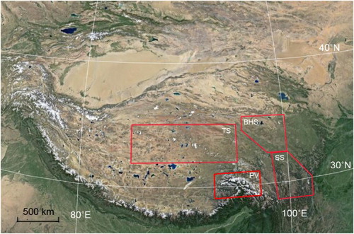
Figure 1. The study region covers the Parlung Zangbo Valley (PV), southeastern Tibetan Plateau. The extents of other glacial geomorphological maps, including Tanggula Shan (TS) by CitationMorén et al. (2011), Bayan Har Shan (BHS) by CitationHeyman et al. (2008), and Shaluli Shan (SS) by CitationFu et al. (2012).
The map presented here focuses on the Parlung Zangbo River Valley in the southeastern Tibetan Plateau. Previous work in this region has identified glacial landforms (CitationChen, Zhou, & Deng, 2013; CitationLi et al., 1986; CitationLoibl & Lehmkuhl, 2015) and provided initial chronological control for some glacial deposits (CitationChen et al., 2014; CitationJiao, Iwata, Yao, Jing, & Li, 2005; CitationLoibl et al., 2015; CitationOu et al., in press; CitationZhou et al., 2007; CitationZhou et al., 2010). However, a detailed map of glacial landforms is still lacking. The map presented here, together with forthcoming results on glacial chronology, will provide important insights into the paleoglaciations of the Parlung Zangbo Valley in the southeastern Tibetan Plateau and improve our understanding of the relationship between tectonic activity and climate change.
2. Physiography of the Parlung Zangbo Valley
The Parlung Zangbo River is a large tributary river of the Yarlung Zangbo River flowing from east to west on the southeastern Tibetan Plateau. The Parlung Zangbo Valley is surrounded by the Nyainqentanglha Shan in the north, the Gangrigabu Shan in the south, and the Himalayas in the southwest. It is a typical region of monsoonal maritime glaciers in China with annual precipitation of ∼3000 mm near the equilibrium-line altitudes (ELAs) (CitationShi, Liu, & Wang, 2006b). The ELAs are approximately 1400–1600 m a.s.l. lower than the northern slopes of the western Himalayas and central Tibetan Plateau (CitationZhou et al., 2010). These glaciers have strong subglacial erosion and high transportation and deposition rates, and have produced abundant glacial landforms in this region ().
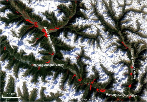
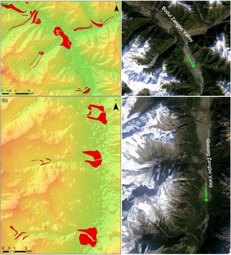
Figure 2. Google Earth imagery of the middle part of the Parlung Zangbo Valley and its tributaries (the Bodui Zangbo Valley and the Quzong Zangbo Valley). Moraines are marked as red polygons.
3. Methods
Esri ArcGIS 10.2.2 was employed to design and to export the final map (Main Map) which contained six kinds of spatial data (e.g. contemporary glaciers, glacial valleys, marginal moraines, hummocky moraines, ice-dammed paleolake and water areas (including rivers and lakes)), background raster (DEM and hillshade images), and landmarks (mountain peaks and cities). Contemporary glaciers were downloaded from the GLIMS website (http://www.glims.org). Glacial landforms, such as glaciers valleys, moraines, and ice-dammed paleolake, were identified and delineated from the 3D landscape view provided by Google Earth. Delineated landforms were saved as KML files in Google Earth and then converted into ArcGIS layers. All the converted layers were exported as shapefiles and reprojected to the Albers equal-area conic projection (central meridian: 95, standard parallels 1: 29, standard parallels 2: 31, latitude of origin: 30, datum: WGS 1984). Each kind of glacial landform was mapped differently for the sake of distinguishing from each other significantly. The ASTER Global Digital Elevation Model (GDEM; 30 meters spatial resolution) was downloaded from the USGS website and used to evaluate the study area. In order to enhance the landform characteristics, a shaded-relief image was calculated based on the GDEM image and was stacked under the GDEM image (GDEM layer and shaded-relief map were set to 60% and 70% transparency, respectively).
Field validation of the mapped landforms was conducted in the middle section of the Parlung Zangbo Valley in 2011 and 2014. The route of field investigation is indicated in . Marginal moraines and Hummocky moraines were identified by their morphological characteristics and composition. Glacial valleys were mainly distinguished by their U-shaped cross-section. An ice-dammed paleolake was confirmed by lacustrine deposits and the geomorphological relationship with related moraines. The surface area of the paleolake was determined by the lakeshore terrace. Glacial valleys, marginal moraines, and hummocky moraines are abundant in the Bodui Zangbo Valley and the Quzong Zangbo Valley ().
Figure 3. Layer colored map of the study area with the locations of , 5a, 5b, 6a, 6b, 7a, 7b, and 8. This shaded-relief map is created using the 30-mASTER Global Digital Elevation Model (2011) (USGS 2014). Field track indicates the route of field investigation. Blue arrows indicate the flow direction of rivers.
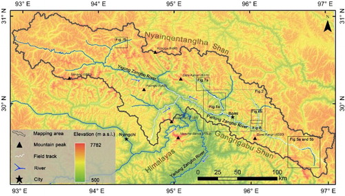
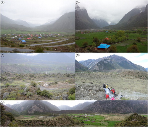
Figure 4. Field photos of glacial features. (a) Glacial valley and (c) hummocky terrains in the Bodui Zangbo Valley. (b) Glacial valley and (d) marginal moraines of the Quzong Zangbo Valley. (e) Tributary glacial valley (left) and main glacial valley (middle) of the Quzong Zangbo Valley, with marginal moraines from tributary valley deposited in the main valley.
4. Landform definitions and descriptions
4.1. Glacial valleys
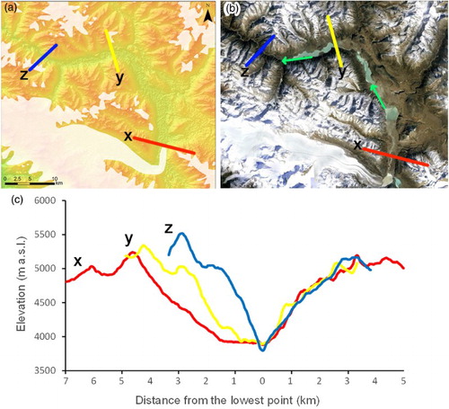
We applied two criteria to identify glacial valleys: (1) U-shaped cross-section and (2) smooth valley sides, reflecting erosion and truncation of valley spurs. The cross-section of a glacial valley is typically U-shaped, in contrast to the V-shaped valleys formed by fluvial incision (CitationHarbor, 1992; CitationLi, Liu, & Cui, 2001a, Citation2001b; CitationMontgomery, 2002; CitationPrasicek, Otto, Montgomery, & Schrott, 2014). The profile tool in Esri ArcGIS was used to examine the cross-section along each valley and detect changes between U-shaped and V-shaped (). It is difficult to identify the trimline on the valley side because of strong post-glacial erosion caused by the humid climate and active tectonic uplift in this area. We therefore focused on the extent of the glacial valley floor, representing the minimum extent of past glaciers.
Figure 5. Glacial valley floors as mapped features in color-rendered DEM (a) and in a Google Earth view (b). Cross-section profiles (x, y and z) are illustrated in (c). The locations of cross profiles x, y (glacial valleys) and z (fluvial valley) are marked in (a). The green arrows indicate the flow direction of Parlung Zangbo River. Its location is indicated in .
4.2. Marginal moraines
Marginal moraines are ridge-shaped landforms produced by glaciers, including terminal moraines and lateral moraines (). Multiple moraines are present in the glacial valleys in this area. For example, three major moraine ridges (>200 m in height) can be identified at the mouth of the Bodui Zangbo Valley. The moraine ridges further down from these three major moraines are only partially preserved due to erosion (CitationChen et al., 2013). Two or three sets of small moraines are also present between these three moraine ridges at the valley mouth and the contemporary glaciers. In addition, along the main valley sides, two moraine ridges are located at much higher elevations than the moraines in the tributary valley. In total, at least seven sets of moraines are preserved in the Parlung Zangbo Valley. The marginal moraine ridges located at the mouth of glacial valley are the best preserved and indicate the longest sustained and stable climate for glacial advances in the past. We mapped the marginal moraines in the whole Parlung Zangbo Valley except for those that cannot be identified on Google Earth.
Figure 6. Marginal moraines of the Bodui Zangbo Valley (a) and Quzong Zangbo Valley (b) illustrated as mapped features on color-rendered DEM overlapped with a semi-transparent hillshade images (left) and in a Google Earth view (right). Their locations are shown in .
4.3. Hummocky moraines
Hummocky moraines are glacial deposits of irregularly shaped hills/mounds and, in the Parlung Zangbo Valley, are mainly located along the valley floor of the Bodui Zangbo Valley and the Yigong Zangbo Valley (). This type of moraine usually has a low relief with multiple glacial processes potentially involved in their formation (CitationBenn & Evans, 2010). A common process is supraglacial debris being deposited irregularly during the uneven ablation of glacial ice that it covers (CitationAndersson & Gunnar, 1998; CitationBenn, 1992; CitationBennett & Boulton, 1993; CitationYang et al., 2005).
Figure 7. The hummocky moraines in the Bodui Zangbo Valley (a) and the Yigong Zangbo Valley (b) mapped on DEM overlapped with a semi-transparent hillshade images (above), and their Google Earth view (below). Locations of the area depicted are marked in .
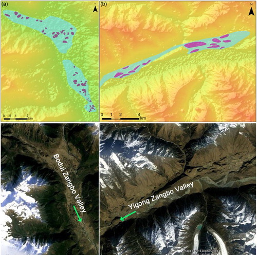
The hummocky moraines mapped in the Bodui Zangbo Valley are found ∼30 km away from the Zepu glacier. The height and diameter of individual hummocky moraine are about 5–20 and 10–30 m, respectively. The hummocky moraines are mainly composed of granite erratics, debris, and sand with various grain sizes. Stratified sub-rounded pebbles are also present in some moraine profiles, indicating the role of melt-water in moraine formation. We interpret that such hummocky moraines were formed by melting of large stagnant glacial ice within the glacial deposits on the flat valley floor. Due to the low relief, we only mapped individual hummocky moraine as dark amethyst polygons that can be identified on Google Earth; the distribution of smaller moraine was mapped in apatite blue ().
4.4. Ice-dammed paleolake
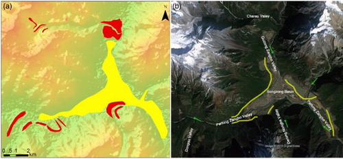
An ice-dammed paleolake was mapped in the Songzong Basin located at the upper and middle reaches of the Parlung Zangbo River (). CitationZeng et al. (2007) reported a lacustrine deposit more than 88 m in thickness. The thickness of successional silty clay in this deposit is 18.3 m. The formation age of this layer is constrained between 22 and 16 ka when the downstream glacier from the Dongqu Valley advanced and blocked the Parlung Zangbo River during the Last Glacial Maximum (LGM) (CitationZeng et al., 2007). The moraine ridges located at the mouth of Dongqu Valley, Charao Valley, and Derong Nongba Valley share similar morphological characteristics with other glacial valleys in the Parlung Zangbo Valley and they were also formed during the LGM (CitationChen et al., 2013, Citation2014). The lacustrine sediments were deposited outside the LGM moraines. Fluvial terrace, lakeshore terrace, and marginal moraines are widely preserved (b). The top altitude of the lacustrine deposit and the paleolake shore terrace is approximately 3100 m a.s.l. Therefore, the ice-dammed paleolake was mapped at 3100 m a.s.l., delimiting an area of 12.5 km2.
Figure 8. Ice-dammed paleolake as yellow polygon and in Songzong Basin with color-rendered DEM image (left), and Google Earth view (right). Related marginal moraines mapped as poinsettia red. Location is marked in .
The mapped region covers 2.9 × 10⁴ km2. Glacial valleys (a total of 922 mapped) are distributed mainly above 2100 m a.s.l. with lengths from 1 to 130 km, covering an area of 4.8 × 10³ km2. The lowest moraines are mainly distributed at the mouth of each valley from 2400 to 4000 m a.s.l., representing the minimum extent of the regional maximum glaciation. We mapped 318 marginal moraines and 68 hummocky moraines, covering an area of 145.7 and 19.1 km2, respectively. One ice-dammed paleolake was mapped in the Songzong Basin with an area of 12.5 km2.
5. Map quality
The map represents the spatial distribution of glacial landforms in the Parlung Zangbo Valley. The entire map area has been carefully examined to identify glacial landforms on the DEM and Google Earth. Field validation in key areas () confirm the mapped landforms, however the resolution of the DEM limits the size of detectable landforms. We did not map marginal moraines and glacial valleys with lengths of less than 50 m and 1 km, respectively. Glacial valleys are mainly identified by the U-shaped cross-section, with smooth valley sides only partly considered due to the extensive post-glacial erosion. Hummocky moraines are mapped partially because of their size limit.
6. Conclusions
Glacial landforms in the Parlung Zangbo Valley show that the extent and style of past glaciations were extensive valley glaciers. We mapped glacial valleys, marginal moraines, hummocky moraines, and one ice-dammed paleolake. Glacial valleys are typically U-shaped with multiple marginal moraines along the valley, indicating the presence of multiple paleoglaciations. Older moraines are only partly preserved due to the high erosion rate in the humid climate (CitationOwen et al., 2005). The best preserved and largest moraines are located at the mouth of the glacial valleys and were formed during LGM (CitationChen et al., 2014; CitationOu et al., in press; CitationZhou et al., 2007, Citation2010). Marginal moraines and glacial valleys are mostly preserved in the Bodui Zangbo Valley, the Quzong Zangbo Valley, the middle-upper reach of Parlung Zangbo Valley, and the downstream reach of the Yigong Zangbo Valley, consistent with the pattern of moisture distribution. CitationOu, Lai, Zhou, and Zeng (2014) suggest that glacial fluctuations in the monsoonal Hengduan Mountains were dominated by temperature oscillations; thus, glacial advances during the late Quaternary responded to cold stages rather than episodes of enhanced summer monsoon and moisture. We assume that glacial expansion is dominated by temperature in the Parlung Zangbo Valley and estimate a temperature lowering of ∼6.3°C during the LGM (CitationChen et al., 2014). Paleo-glaciers advanced more extensively in the upper reaches of the Yigong Zangbo Valley than within the middle reach due to the higher altitude which supported lower temperatures even without rich moisture nourishment. Hummocky moraines are mainly distributed in the Bodui Zangbo Valley and the Yigong Zangbo Valley, providing evidence of glacier fluctuations. The ice-dammed paleolake reflects the interplay between paleo-glaciers and fluvial processes in the Songzong Basin.
The mapped glacial features, including contemporary glaciers, glacial valleys, marginal moraines, hummocky moraines, and the ice-dammed paleolake, cover a total area of 1.2 × 10⁴ km2, about 40% of the whole mapping area, representing the minimum extent of the maximum glaciation in this region.
Software
ENVI 4.8 was used for DEM analysis. Esri ArcGIS 10.2 was used to create the hillshade, and design, and create the map. Google Earth provided 3D visualization of the study area. Adobe Photoshop CS4 was used for additional edits of the map.
Data
The author has supplied data (as an ESRI Shape file) used in the production of the accompanying map. The contents of the ZIP file are the sole responsibility of the authors.
Glacial geomorphology of the Parlung Zangbo Valley, southeastern Tibetan Plateau
Download PDF (24.6 MB)Acknowledgements
We are grateful to reviewers and editors for constructive reviews that significantly improved the manuscript.
Disclosure statement
No potential conflict of interest was reported by the authors.
Additional information
Funding
References
- An, Z., Kutzbach, J. E., Prell, W. L., & Porter, S. C. (2001). Evolution of Asian monsoons and phased uplift of the Himalaya–Tibetan plateau since late Miocene times. Nature, 411(6833), 62–66. doi:10.1038/35075035
- Andersson, G. (1998). Genesis of hummocky moraine in the Bolmen area, southwestern Sweden. Boreas, 27(1), 55–67. doi:10.1111/j.1502-3885.1998.tb00867.x
- Benn, D. I. (1992). The genesis and significance of ‘hummocky moraine’: Evidence from the Isle of Skye, Scotland. Quaternary Science Reviews, 11(7), 781–799. doi:10.1016/0277-3791(92)90083-K
- Benn, D. I., & Evans, D. J. A. (2010). Glaciers and glaciation. London: Hodder Education.
- Bennett, M. R., & Boulton, G. S. (1993). A reinterpretation of Scottish ‘hummocky moraine'and its significance for the deglaciation of the Scottish highlands during the younger Dryas or Loch Lomond Stadial. Geological magazine, 130(03), 301–318. doi:10.1017/S0016756800019993
- Blomdin, R., Heyman, J., Stroeven, A. P., Hättestrand, C., Harbor, J. M., Gribenski, N.,… Alexander, O. (in press). Glacial geomorphology of the Altai and Western Sayan mountains, Central Asia. Journal of Maps, 1–14. doi:10.1080/17445647.2014.992177
- Chen, R. R., Zhou, S. Z., & Deng, Y. B. (2013). The morphological characteristics of glacial deposits during the last glaciation, taking the Parlung Zangbo River Basin as an example. Sciences in Cold and Arid Regions, 6, 698–708. doi:10.3724/SP.J.1226.2013.00698
- Chen, R. R., Zhou, S. Z., Lai, Z. P., Ou, X. J., Chen, R., & Deng, Y. B. (2014). Luminescence chronology of late Quaternary moraines and last glacial maximum equilibrium-line altitude reconstruction from Parlung Zangbo valley, south-eastern Tibetan Plateau. Journal of Quaternary Science, 29(6), 597–604. doi:10.1002/jqs.2733
- Chen, Y. X., Li, Y. K., Wang, Y. Y., Zhang, M., Cui, Z. J., Yi, C. L., & Liu, G. N. (2015). Late quaternary glacial history of the Karlik range, easternmost Tian Shan, derived from 10Be surface exposure and optically stimulated luminescence dating. Quaternary Science Reviews, 115, 17–27. doi:10.1016/j.quascirev.2015.02.010
- Clark, M. K., House, M., Royden, L., Whipple, K., Burchfiel, B., Zhang, X., & Tang, W. (2005). Late Cenozoic uplift of southeastern Tibet. Geology, 33(6), 525–528. doi:10.1130/G21265.1
- Fu, P., Heyman, J., Hättestrand, C., Stroeven, A. P., & Harbor, J. M. (2012). Glacial geomorphology of the Shaluli Shan area, southeastern Tibetan Plateau. Journal of Maps, 8(1), 48–55. doi:10.1080/17445647.2012.668762
- Harbor, J. M. (1992). Numerical modeling of the development of U-shaped valleys by glacial erosion. Geological Society of America Bulletin, 104(10), 1364–1375. doi:10.1130/0016-7606(1992)104<1364:NMOTDO>2.3.CO;2
- Heyman, J., Hättestrand, C., & Stroeven, A. P. (2008). Glacial geomorphology of the Bayan Har sector of the NE Tibetan Plateau. Journal of Maps, 4(1), 42–62. doi:10.4113/jom.2008.96
- Jiao, K. Q., Iwata, S., Yao, T. D., Jing, Z. F., & Li, Z. Q. (2005). Variation of Zepu Glacier and environmental change in the eastern Nyainqentanglha range since 3. 2 ka BP. Journal of Glaciology and Geocryology, 27(1), 74–79.
- Klinge, M., & Lehmkuhl, F. (2004). Pleistocene glaciations in southern and eastern Tibet. In J. Ehlers & P. L. Gibbard (Eds.), Quaternary glaciations extent and chronology, Part III: South America, Asia, Africa, Australasia, Antarctica (pp. 361–369). Amsterdam: Elsevier.
- Lehmkuhl, F., & Liu, S. (1994). An outline of physical geography including Pleistocene glacial landforms of eastern Tibet (provinces Sichuan and Qinghai). GeoJournal, 34(1), 7–30. doi:10.1007/BF00813966
- Li, B., Li, J., & Cui, Z. (1991). Quaternary glacial distribution map of Qinghai-Xizang (Tibet) Plateau. Beijing: Science Press.
- Li, J. J., Zheng, B. X., Yang, X. J., Xie, Y. Q., Zhang, L. Y., Ma, Z. H., & Xu, S. Y. (1986). Glaciers in Tibet. Beijing: Science Press.
- Li, Y., Liu, G., & Cui, Z. (2001a). Glacial valley cross-profile morphology, Tian Shan Mountains, China. Geomorphology, 38(1), 153–166. doi:10.1016/S0169-555X(00)00078-7
- Li, Y. K., Liu, G. N., Chen, Y. X., Li, Y. N., Harbor, J., Stroeven, A. P.,… Cui, Z. J. (2014). Timing and extent of quaternary glaciations in the Tianger range, eastern Tian Shan, China, investigated using 10Be surface exposure dating. Quaternary Science Reviews, 98, 7–23. doi:10.1016/j.quascirev.2014.05.009
- Li, Y. K., Liu, G. N., & Cui, Z. J. (2001b). Longitudinal variations in cross-section morphology along a glacial valley: A case-study from the Tien Shan, China. Journal of Glaciology, 47(157), 243–250. doi:10.3189/172756501781832278
- Li, Y. K., Liu, G. N., Kong, P., Harbor, J., Chen, Y. X., & Caffee, M. W. (2011). Cosmogenic nuclide constraints on glacial chronology in the source area of the Urumqi River, Tian Shan, China. Journal of Quaternary Science, 26, 297–304. doi:10.1002/jqs.1454
- Liu, G., Zhang, X., Cui, Z., Wu, Y., & Ju, Y. (2006). A review of glacial sequences of the Kunlun Pass, northern Tibetan Plateau. Quaternary International, 154, 63–72. doi:10.1016/j.quaint.2006.02.004
- Loibl, D., Hochreuther, P., Schulte, P., Hülle, D., Zhu, H., Br01uning, A., & Lehmkuhl, F. (2015). Toward a late Holocene glacial chronology for the eastern Nyainqêntanglha Range, southeastern Tibet. Quaternary Science Reviews, 107, 243–259. doi:dx.doi.org/10.1016/j.quascirev.2014.10.034
- Loibl, D. M., & Lehmkuhl, F. (2015). Glaciers and equilibrium line altitudes of the eastern Nyainqêntanglha Range, SE Tibet. Journal of Maps, 11(4), 575–588. doi:10.1080/17445647.2014.933451
- Miao, Y., Herrmann, M., Wu, F., Yan, X., & Yang, S. (2012). What controlled mid–late Miocene long-term aridification in Central Asia?—Global cooling or Tibetan Plateau uplift: A review. Earth-Science Reviews, 112(3), 155–172. doi:10.1016/j.earscirev.2012.02.003
- Montgomery, D. R. (2002). Valley formation by fluvial and glacial erosion. Geology, 30(11), 1047–1050. doi:10.1130/0091-7613(2002)030<1047:VFBFAG>2.0.CO;2
- Morén, B., Heyman, J., & Stroeven, A. P. (2011). Glacial geomorphology of the central Tibetan Plateau. Journal of Maps, 7(1), 115–125. doi:10.4113/jom.2011.1161
- Ou, X., Duller, G. A. T., Roberts, H. M., Zhou, S., Lai, Z., Chen, R., … Zeng, L. (in press). Single grain optically stimulated luminescence dating of glacial sediments from the Baiyu valley, southeastern Tibet. Quaternary Geochronology. doi:10.1016/j.quageo.2015.02.018
- Ou, X., Lai, Z., Zhou, S., & Zeng, L. (2014). Timing of glacier fluctuations and trigger mechanisms in eastern Qinghai-Tibetan plateau during the late quaternary. Quaternary Research, 81, 464–475. doi:dx.doi.org/10.1016/j.yqres.2013.09.007
- Owen, L., Finkel, R., Barnard, P., Haizhoud, M., Asahie, K., Caffeef, M., & Derbyshire, E. (2005). Climatic and topographic control on the style and timing of late quaternary glaciation throughout Tibet and the Himalaya defined by 10Be cosmogenic radionuclide surface exposure dating. Quaternary Science Reviews, 24, 1391–1411. doi:10.1016/j.quascirev.2004.10.014
- Prasicek, G., Otto, J.-C., Montgomery, D. R., & Schrott, L. (2014). Multi-scale curvature for automated identification of glaciated mountain landscapes. Geomorphology, 209, 53–65. doi:10.1016/j.geomorph.2013.11.026
- Royden, L. H., Burchfiel, B. C., & van der Hilst, R. D. (2008). The geological evolution of the Tibetan plateau. Science, 321(5892), 1054–1058. doi:10.1126/science.1155371
- Shi, Y. F., Cui, Z. J., & Su, Z. (2006a). The quaternary glaciations and environmental variations in China. Shijiazhuang: Hebei Science and Technology Press.
- Shi, Y. F., Liu, C. H., & Wang, Z. (2006b). Catalogue of glaciers in China. Shanghai: Shanghai Press of Science & Technology.
- Stroeven, A. P., Hättestrand, C., Heyman, J., Kleman, J., & Morén, B. M. (2013). Glacial geomorphology of the Tian Shan. Journal of Maps, 9(4), 505–512. doi:10.1080/17445647.2013.820879
- Wang, J., Zhou, S., Zhao, J., Zheng, J., & Guo, X. (2011). Quaternary glacial geomorphology and glaciations of Kongur mountain, eastern Pamir, China. Science China Earth Sciences, 54(4), 591–602. doi:10.1007/s11430-010-4165-y
- Xu, X., Kleidon, A., Miller, L., Wang, S., Wang, L., & Dong, G. (2010). Late quaternary glaciation in the Tianshan and implications for palaeoclimatic change: a review. Boreas, 39(2), 215–232. doi:10.1111/j.1502-3885.2009.00118.x
- Yanai, M., & Wu, G. X. (2006). Effects of the Tibetan plateau. The Asian monsoon. Heidelberg: Springer, pp. 513–549.
- Yang, W., Zhou, S., Wang, J., Wang, X., Sun, A., Xu, L., & Han, H. (2005). Formation mechanism of Hummocky Moraine in the Bodui Zangbo valley and its environmental significance. Journal of Glaciology and Geocryology, 27(02), 220–225.
- Zeng, Q., Yang, Z., Yuan, G., Shang, Y., Zhang, L., & Zhao, X. (2007). Songzong lake: An ice dammed lake of last glacial maximum in Purlung Zangbo river, southeast Tibet. Quaternary Sciences, 27, 85–92.
- Zhao, J., Song, Y., King, J. W., Liu, S., Wang, J., & Wu, M. (2010). Glacial geomorphology and glacial history of the Muzart river valley, Tianshan range, China. Quaternary Science Reviews, 29(11), 1453–1463. doi:10.1016/j.quascirev.2010.03.004
- Zhao, J., Wang, J., Harbor, J. M., Liu, S., Yin, X., & Wu, Y. (2015). Quaternary glaciations and glacial landform evolution in the Tailan river valley, Tianshan Range, China. Quaternary International, 358, 2–11. doi:10.1016/j.quaint.2014.10.029
- Zheng, B. X., & Rutter, N. (1998). On the problem of quaternary glaciations, and the extent and patterns of Pleistocene ice cover in the Qinghai-Xizang (Tibet) Plateau. Quaternary International, 45, 109–122. doi:10.1016/S1040-6182(97)00009-8
- Zhou, S. Z., Li, J. J., Zhang, S. Q., Zhao, J. D., & Cui, J. X. (2004). Quaternary glaciations in China. In J. Ehlers & P. L. Gibbard (Eds.), Quaternary glaciations extent and chronology, Part III: South America, Asia, Africa, Australasia, Antarctica (pp. 105–113). Amsterdam: Elsevier.
- Zhou, S. Z., Wang, J., Xu, L. B., Wang, X. L., Colgan, P. M., & Mickelson, D. M. (2010). Glacial advances in southeastern Tibet during late quaternary and their implications for climatic changes. Quaternary International, 218(1), 58–66. doi:10.1016/j.quaint.2009.11.026
- Zhou, S. Z., Xu, L. B., Colgan, P. M., Mickelson, D. M., Wang, X. L., Wang, J., & Zhong, W. (2007). Cosmogenic 10Be dating of Guxiang and Baiyu glaciations. Chinese Science Bulletin, 52(10), 1387–1393. doi:10.1007/s11434-007-0208-y