
ABSTRACT
This paper presents a geomorphologic map of the Mt. Prinzera ultramafic rock complex (Parma Province, Emilia-Romagna Region, Italy) mapped at large scale (1:2500). The map is the first contribution to the detailed geomorphologic knowledge of the area within the framework of a multidisciplinary approach used to analyse Mt. Prinzera as a hard rock aquifer case study. The geomorphologic mapping was carried out by field survey and aerial photograph analysis. All the surface processes and landforms were considered, with particular attention to structural geomorphologic features. The mapping of linear morphologic features was considered useful for revealing the presence of sets of joints otherwise difficult to detect due to surface weathering. Sets of rock discontinuities are important for water seepage and percolation and their identification is crucial for developing the hydrogeological conceptual model of the aquifer.
1. Introduction
In the Northern Apennines decametric to kilometric bodies of ultramafic rock (the so-called pietre verdi, i.e. green rocks) are located in Upper Cretaceous sedimentary melanges, and represent huge blocks of oceanic lithosphere which slid into the External Ligurian sedimentary basin (CitationAbbate et al., 1988). Many olistoliths of basalts and peridotites are embedded in prevalent pelitic rock complexes of External Ligurian units which represent the stratigraphic base of the Helminthoid Flysch (Upper Cretaceous) (CitationElter, Marroni, Molli, & Pandolfi, 1991; CitationMarroni, Meneghini, & Pandolfi, 2010). Ultramafic rock complexes have been studied from a geological perspective (CitationPagani et al., 1972) and they are often considered geomorphosites because of their importance for the geological history of the Northern Apennines and their specific morphological and environmental meaning.
Over the last decade, the role that pietre verdi play as important aquifers has also been evaluated (CitationDewandel et al., 2005; CitationSegadelli, 2014), owing to the large amount of water that they can store. A research project started in 2010 aimed to characterize these rock aquifers and implement a hydrogeological conceptual model (CitationSegadelli, 2014). These rocks’ structural and tectonic features are relevant because rock discontinuities play the important role of routeways for water seepage and percolation (CitationTeixeira, Chaminé, Carvalho, Pérez-Alberti, & Rocha, 2013). However, the true extent and diffusion of discontinuities were difficult to detect because of surface processes responsible for the weathering and reshaping of the rock surface.
Morphostructural features are usually recognized and mapped as part of medium- to small-scale geomorphological surveys and sometimes are the topic of regional structural and tectonic oriented geomorphological maps (CitationBoenzi, Capolongo, Gallicchio, & Di Pinto, 2014; CitationMiccadei, Piacentini, Dal Pozzo, La Corte, & Sciarra, 2013; CitationMiccadei, Piacentini, Gerbasi, & Daverio, 2012; CitationSanto et al., 2014).
This paper presents a large-scale geomorphological map of Mt. Prinzera's ultramafic rock complex, on which a multidisciplinary approach was used in order to analyse it as a paradigmatic case study, with the aim of proposing a conceptual hydrogeological model valid for other similar ophiolite hard rock aquifers. All geomorphological processes and landforms were considered in the survey, and the morphostructural features of the area were, in particular, investigated. Indeed, the large-scale survey of mainly linear morphological features was considered useful in revealing the presence of sets of joints and rock discontinuities.
2. General setting
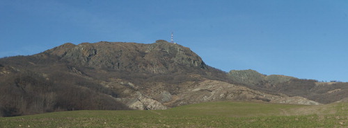
Mt. Prinzera (Lat. 44°38′30″N, Long. 10°5′E, 725 m a.s.l.) is an ophiolite outcrop of the External Ligurian units of the Northern Apennines (see the tectonic sketch in the Main Map). It appears as an orographic culmination of the gentle watershed between the valleys of the Taro River (on the left) and the Sporzana Stream (on the right), the latter being a tributary of the Taro River. It consists of an ultramafic body of serpentinites and peridotites breccias, with a maximum thickness of about 250 m. Selective erosion has removed the surrounding pelitic soft rocks leaving the ultramafic olistolith emergent in the landscape ().
Figure 1. The landscape view of Mt. Prinzera's eastern side. The ophiolitic rock complex rises from the surrounding gentler slopes made up of soft rocks (clay-rich breccias and flysch). The rock mass is divided into several portions (in the middle/left-hand side of the photograph the principal one and on the right-hand side the secondary blocks) because of the presence of E-W fault system.
At a regional scale the area has been the subject of several studies that have shown the geological and structural characteristics (CitationZanzucchi, 1980 and references therein; CitationDi Dio, Martini, Lasagna, & Zanzucchi, 2005; CitationRicci Lucchi, 1990). However, this study represents the first real contribution to the detailed knowledge of Mt. Prinzera's ophiolite mass which has so far never been undertaken.
Mt. Prinzera shows an asymmetric E-W topographic profile. The eastern hillslopes are steep with frequent vertical rock walls, whereas the western slopes are gentler despite the notable outcrops of rocks. Both Mt. Prinzera's eastern and western hillslopes show several areas which are bare, or have scarce or no vegetation.
Data on precipitation (rainfall and snow) for the period 2000–2013 (raingauges: Boschi di Bardone, Lat. 44°37′59″N Long. 10°05′08″E, 620 m a.s.l.; Varano Marchesi, Lat. 44°44′0.24″N Long. 10°01′25″E, 440 m a.s.l.; Calestano Lat. 44°36′21.29″N Long. 10°07′28.27″E, 420 m a.s.l.) show that the mean annual precipitation ranged from a minimum of 589 mm to a maximum of 1657 mm, with a mean value of 946 mm, for an average of 70–100 rainy days per year. Many significant rainfall events have occurred in the area: that is, on 19 May 2008 there were 92 mm rainfall in 24 h. The rainfall regime is typical of the sublittoral Apennines climate, characterized by two peaks, the higher in autumn (October–November) and the other in spring (March–April); there are also two minima, the lower in July and the other in January. The months with the highest number of rainy days are: April and the period October–November, while the months with the lowest number of rainy days are July and August.
The average number of snowy days is between 10 and 25 per year, usually distributed in the period from November to February, with peaks in January. The maximum height of the snowpack can reach 60 cm. For air temperature, the data for the period 2000–2012 show the absolute minimum, −15°C, reached 6 February 2012, and the hottest temperature 40°C reached on 11 August 2003. The average daily temperature ranges from a minimum of 8.7°C to a maximum of 19.8°C. The cold period is from December to February, while the hottest spans from June to August.
3. Materials and methods
This work was carried out by field survey, using the Technical Regional Map as a basemap (1:5000), integrated with aerial photographs (http://geoportale.regione.emilia-romagna.it). In particular:
Black and white aerial photographs at scale 1:15,000 taken between March and July 1973;
Black and white aerial photographs Volo Italia at scale 1:35,000 taken on 25 May 1993;
Black and white aerial photographs ‘Volo G.A.I.’ at scale 1:33,000 taken on 3 July 1954;
Coloured orthophotographs Emilia-Romagna and A.G.E.A., with 50 cm average pixel size and pictures taken between June and August 2008;
Coloured orthophotographs A.G.E.A., with 50 cm average pixel size and pictures taken between May and June 2011.
The elements that can be recognized by aerial photo examination and field mapping, and reported in the geomorphological map of the study area, are described below.
4. Mt. Prinzera's geomorphological map
4.1. Lithological data
The lithologies outcropping in the area were grouped into four different morpholithologic units. From a geological perspective, they belong to ‘Case Boscaini’ group (Campanian) and Helminthoid Flysch (Maastrichtian-Danian) (CitationDi Dio et al., 2005).
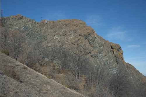
Peridotites: the unit consists of prevailing massive peridotites and breccias of different grain size, with phacoidal or sheet-like planar foliation. Serpentine is gathered along the discontinuities of the rock mass. The rock colour varies from dark green to black and the unit is about 250 m thick. ();
Peridotite breccias: dark green to black breccias consist of centimetric to decimetric clasts in a sandy matrix of the same material; the maximum thickness is about 15 m;
Helminthoid flysch: the rock unit is made up of fine calcarenites, grey to hazel or dark grey, and marly clay grey to hazel; the beds are medium to thick and A/P ≥ 1. Thick to very thick beds of white marls, with calcarenite base, and thin to medium beds of white limestones occur. The total thickness of this unit may reach 250 m;
Poligenic breccias: the rock unit is made up of clasts of grey to green limestones, marly limestones and silty sandstones in a red or dark grey to blue clay matrix.
Figure 2. Massive peridotites outcrop and correspond to Mt. Prinzera's eastern slope. The picture clearly shows the pervasive planar foliation of the rock mainly due to tectonic deformation.
On the geomorphological map, different morpholithologic units are separated by tectonic boundaries, as noted by CitationDi Dio et al. (2005).
4.2. Tectonic and structural landforms
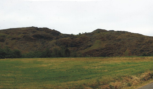
Landforms, such as trenches (see photo 5 in the Main Map), scarps (see photo 3 in the Main Map) and rock gullies () were recognized along the hillslopes of Mt. Prinzera. NW-SE and NE-SW scarps and gullies have lengths that vary from a few to tens of metres. Scarps are generally very steep or vertical and are mainly found in the western sector of Mt. Prinzera. Gullies, deeply incised in the bedrock appear as linear features following the maximum slope angle and are, in general, wide straight channels. The channel bottom usually lacks deposits because run-off during significant rainfall events erodes and washes away any material. Sometimes only patches of colluvial deposits cover the bottom of the channel and the foot of the scarps.
Figure 3. Gullies entrenched along Mt. Prinzera's hillslope are the most widespread forms controlled by structural features. They are dry, or almost dry, most of the time, while during rainfalls, or shortly after, they become full of water which quickly runs down the slope, as in the case of the gully shown in the picture of Mt. Prinzera's western side.
Besides the two main NW-SE and NE-SW strikes, trenches also show a N-S secondary strike. They are narrow and straight and usually limited by sharp vertical scarps with height varying between a few decimeters and a few metres. The bottom is often covered in debris made up of centimetric to decimetric angular clasts with a scarce sandy-silt matrix. Trenches are equally distributed over the whole surface of the ophiolithic complex and are usually 10–20 m long and up to 20–40 cm wide.
Small gaps () break the ridges that show planar and/or altimetric discontinuities. The gaps are mainly located in the central part of Mt. Prinzera's rock mass. The width varies from 10 to 45 m for gaps shaped in the ophiolitic rock, and from 15 to 50 m for those shaped in the marly limestone bedrock.
Figure 4. The gap shown in the picture, corresponding with Mt. Prinzera's southern sector, is one of the better developed in the study area. These landforms are often aligned with linear forms, such as gullies and rills.
Aligned landforms can be recognized in the area too. In some circumstances, the alignment of ridges and trenches is noteworthy, such as with M. Prinzerotto. In other cases, ridges and trenches may be aligned with gaps, as visible to the south of Case Prinzera or north-east of Boschi di Bardone. In these instances, the gaps are aligned but arranged orthogonally to the other forms as they are related to faults that cut the ridges. Moreover, gullies are also developed along the same alignments of forms, highlighting the existence of control exerted on the erosion of running water. The development of parallel gullies and rills on Mt. Prinzera's western side is worth noting as it is emphasized by the presence of scarps parallel to the previous features.
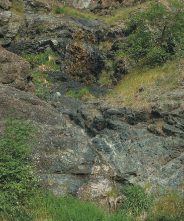
In general, Mt. Prinzera's ophiolitic body is crossed by several systems of fractures. In detail, a large portion of the bedrock appears to be detensioned (). The opening fracture ranges
Figure 5. The discontinuities are often pervasive and open, thus the rocks appear completely detensioned, as in the outcrop of peridotites shown (see photograph number 3 on the geomorphological map).
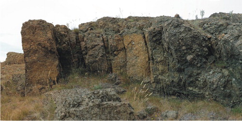
from a few mm to 3–5 cm. The bedrock surface may be covered by debris due to weathering of the rock itself, generally without matrix.
In the northern part of the investigated area, it was possible to recognize some surfaces that are located between 500 and 600 m a.s.l. They are shaped in the massive peridotites and in the flysch rocks and are almost flat or gently sloping uniform surfaces, scarcely incised by the erosive processes acting in the area. Their shape could indicate that their development was caused by erosive processes which removed surface material from an extensive area rather than by the action of erosion acting in a well-defined direction (i.e. rill and gully erosion). This might support the hypothesis that the genesis of these surfaces was driven by planar structural or tectonic features.
4.3. Weathering deposits
Weathered in situ deposits are widespread in the upper part of Mt. Prinzera's southern hillslope. They are debris cover made up of ophiolitic and white calcareous clasts, variable in size from 10–20 cm to 50 cm (cobbles and boulders), and of a light grey sandy-silt matrix. The ophiolitic rock pieces are generally rounded or subrounded, while the calcareous clasts are from angular to rounded. The longest axis (ɑ-axis) of some boulders may be over 50 cm, up to 150 cm. These deposits show poor drainage capacity (CitationSegadelli, 2014). The pieces of limestone derive from lithology pertaining to the Case Boscaini group (CitationDi Dio et al., 2005) and might represent a residual cover due to the weathering of this formation.
4.4. Landforms, deposits and processes due to the running waters
Erosional processes due to running water are enhanced because of the high amount of annual rainfalls. Rills are the most widespread landform in the ophiolitic rock mass due to surface water erosion. They are parallel linear features, usually eroded into the regolith covering the rock and, seldom, in to the bedrock. Generally, they give rise to networks made up of parallel metric to decametric channels with limited hierarchy. Rills are usually NW-SE and NE-SW oriented and are particularly well developed along the western slope of the ophiolitic rock mass.
Corresponding to the margins of weathering deposits are erosive scarps which have been heavily reshaped by running water and, to a lesser extent, eluvial and colluvial deposits.
Colluvial deposits are made up of ophiolitic pebbles and a deep-red silty sand matrix (see photo 4 in the Main Map). The deposits are matrix-supported and, in contrast to the weathering deposits, lack calcareous elements, in both the clasts and matrix. Therefore, these deposits are genetically connected to slope wash affecting the ophiolitic mass. They are widespread in the western sector of Mt. Prinzera and accumulate on gentle (low-angle) slopes or in the wide deep-valley. Unlike the weathering deposits, the colluvial deposits show good drainage capacity (CitationSegadelli, 2014).
Active debris flow cones are identified at the base of Mt. Prinzera's eastern slope. Debris flows are limited to areas of steep relief whose valley sides are steeper than 45° or at the mouth of deep bedrock gullies. During a debris flow, a mixture of blocks, gravel, clay and water moves rapidly down slope. Once the flow has stopped, the deposit displays characteristic surface features such as lobate forms and paired levees along the sides of the flow channel. However, debris flows occurring in the area generally involve a limited volume of debris, therefore they give rise to ephemeral landforms only.
4.5. Landslides and mass wasting
Active scree slopes have been recognized at the base of the eastern and northern slopes of Mt. Prinzera. They are formed by angular fragments and, in some circumstances, they derive from coalescent talus cones. Mt. Prinzera's eastern hillslope, varying from sloping to vertical, is characterized by pervasive fracture systems that control the output and size of rock fragments (from 10–20 to 50 cm). Scree slopes are affected by processes due to running water probably when intense rainfall events occur.
The Emilian Apennines are largely imprinted by landslides. In particularly, in the study area the slopes surrounding Mt. Prinzera are affected by rock and earth slides, earth flows and complex landslides (rock rotational or translational slide-earth flows). From a morphodynamic perspective, dormant and active processes have been recognized. The deposits of active landslides are generally well recognizable with respect to the surroundings. They are characterized by fresh forms, such as hollows and humps, usually of small size, and a surface completely lacking in vegetation cover. Dormant landslides have a longer extent and the surface is covered in vegetation; they sometimes show local reactivations. Large dormant landslides are widespread in the study area and often show a close relationship with the bedrock's structural and tectonic features (CitationChelli, Ruffini, Vescovi, & Tellini, 2013).
The earth flows show a striped form and generally move in relation to the local watershed, while the foot is usually a fan. The deposits are mainly made up of a sandy-silt matrix that may include cobbles and boulders of the prevailing calcareous material. The most interesting examples of these deposits can be observed in the eastern area, along the Rio della Sgalara and Rio delle Bratte.
5. Discussion and conclusions
The geomorphological mapping allowed us to highlight comprehensively the extent, orientation and alignment of the main tectonic and structural elements that affect Mt. Prinzera's ophiolitic rock. In detail, it has been possible to recognize:
systems of linear forms, such as scarps, rills and small ravines, that were developed according to two principal orientations NE-SW and NW-SE, which in turn allowed us to recognize the existence of sets of discontinuities in the ultramafic rock mass; later, the structural geological survey revealed the existence of faults and fractures developed in the rocky mass as a result of a compressive regime (see the stereonets a and b in the Main Map); the influence exerted by faults and fractures on the development of linear forms is also clear because they are straight features parallel to each other;
rills, scarps and gullies are sometimes aligned with each other and with gaps and/or trenches; these alignments of landforms go through most of Mt. Prinzera's rock mass; gaps are generally oriented following the E-W strike; these landforms were controlled by a fault system (see the stereonet c in the Main Map) having a significant impact on the hydrogeology of Mt. Prinzera's hard rock aquifer (CitationSegadelli, 2014);
flat or faintly sloping uniform rock surfaces, probably shaped by erosive processes working over a wide area; the development of these surfaces might have been driven by the existence of low-angle reverse-slip faults (see the stereonet b in the Main Map);
colluvial and residual deposits, with variable thickness, are often recognized at the bottom of trenches and hollows of different kinds; these deposits are important because the area around Mt. Prinzera has scarce vegetation cover and agricultural fields are practically absent; thus the role of these deposits is remarkable because they slow surface run-off, promoting effective seepage in to the subsoil;
the presence of landslides of different types and state of activity all around Mt. Prinzera. They are caused mainly by water outflow from the ophiolite rock mass that percolate the surrounding hillslopes. In fact, the contact between the intensely fractured permeable peridotites and the underlying clay-rich rocks (breccias and flysch) has created numerous springs that promote slope instability.
This study represents the first contribution to the knowledge of the large-scale geomorphology of Mt. Prinzera's ophiolitic complex. In detail, it has shown the importance of large-scale geomorphological mapping in revealing the bedrock's structural features. The mapping of, mainly, linear structural forms has allowed us to identify systems of fractures and faults, representing water seepage and percolation, and was crucial for the construction of the aquifer's hydrogeological conceptual model (CitationSegadelli, 2014).
Software
The geomorphological database was developed using Esri ArcGIS Desktop 10.0 and QGIS.
Large-scale geomorphological mapping as a tool to detect structural features: the case of Mt. Prinzera's ophiolite rock mass (Northern Apennines, Italy)
Download PDF (12.1 MB)Acknowledgements
The Authors gratefully acknowledge Prof. Fulvio Celico for the critical review of the manuscript and Prof. Giuliana Villa for the age determination of poligenic breccias through biostratigraphic analysis. The Authors also acknowledge Editor-in-Chief Mike J. Smith and the reviewers for their suggestions and recommendations that greatly improved the first version of the manuscript.
Disclosure statement
No potential conflict of interest was reported by the authors.
ORCID
Alessandro Chelli http://orcid.org/0000-0001-5035-733X
Related Research Data
References
- Abbate, E., Bortolotti, V., Conti, M., Marcucci, M., Principi, G., Passerini, P., & Treves, B. (1988). Apennines and Alps ophiolites and the evolution of the western Tethys. Memorie della Società Geologica Italiana, 31, 23–44.
- Boenzi, F., Capolongo, D., Gallicchio S., & Di Pinto, G. (2014). Morphostructure of the Lucania Apennines front between the Basento and Salandrella rivers (Southern Italy). Journal of Maps, 10, 478–486. doi:10.1080/17445647.2014.888017
- Chelli, A., Ruffini, A., Vescovi, P., & Tellini, C. (2013). Tectonics and large landslides in the Northern Apennines (Italy). In C. Margottini, P. Canuti, & K. Sassa (Eds.), Landslide science and practice (Vol. 1, pp. 273–279). Berlin Heidelberg: Springer-Verlag. doi:10.10007/978-3-642-31325-7_36
- Dewandel, B., Lachassagne, P., Boudier, F., Al-Hattali, S., Ladouche, B., Pinault, J. L., & Al-Suleimani, Z. (2005). A conceptual hydrogeological model of ophiolite hard-rock aquifers in Oman based on a multiscale and a multidisciplinary approach. Hydrogeology Journal, 13, 708–726. doi: 10.1007/s10040-005-0449-2
- Di Dio, G., Martini, A., Lasagna, S., & Zanzucchi, G. (2005). Note illustrative della Carta Geologica d'Italia alla scala 1:50.000, Foglio n. 199 Parma Sud-Ovest [Sheet n. 199 Parma Sud-Ovest, Servizio Geologico della Regione Emilia-Romagna, Servizio Geologico Nazionale, ISPRA, Roma].
- Elter, P., Marroni, M., Molli, G., & Pandolfi, L. (1991). Le caratteristiche stratigrafiche del Complesso di M. Penna/Casanova (Alta Val Trebbia, Appennino settentrionale). Atti Ticinensi di Scienze della Terra, 34, 97–106.
- Marroni, M., Meneghini, F., & Pandolfi, L. (2010). Anatomy of the Ligure-Piemontese subduction system: Evidence from late Cretaceous-middle Eocene convergent margin deposits in the Northern Apennines, Italy. International Geology Review, 1–33. doi:10.1080/00206810903545493
- Miccadei, E., Piacentini, T., Dal Pozzo, A., La Corte, M., & Sciarra, M. (2013). Morphotectonic map of the Aventino-Lower Sangro valley (Abruzzo, Italy), scale 1:50,000. Journal of Maps, 9, 390–409. doi:10.1080/17445647.2013.799050
- Miccadei, E., Piacentini, T., Gerbasi, F., & Daverio, F. (2012). Morphotectonic map of the Osento River basin (Abruzzo, Italy), scale 1:30,000. Journal of Maps, 8, 62–73. doi:10.1080/17445647.2012.668764
- Pagani, G., Papani, G., Rio, D., Torelli, L., Zanzucchi, G., & Zerbi, M. (1972). Osservazioni sulla giacitura delle ofioliti nelle alte valli del T. Ceno e del F. Taro. Memorie della Società Geologica Italiana, 11, 531–546.
- Ricci Lucchi, F. (1990). Turbidites in foreland and on-thrust basins of the northern Apennines. Palaeogeography, Palaeoclimatology, Palaeoecology, 77, 51–66. doi: 10.1016/0031-0182(90)90098-R
- Santo, A., Ascione, A., Di Crescenzo, G., Miccadei, E., Piacentini, T., & Valente, E. (2014). Tectonic-geomorphological map of the middle Aterno River valley (Abruzzo, Central Italy). Journal of Maps, 10, 365–378. doi:10.1080/17445647.2013.867545
- Segadelli, S. (2014). Funzionamento idrogeologico di acquiferi peridotitici: il caso del M. Prinzera (Appennino settentrionale, Italia) (Unpublished doctoral dissertation). University of Parma, Parma, Italy.
- Teixeira, J., Chaminé, H. I., Carvalho, J. M., Pérez-Alberti, A., & Rocha, F. (2013). Hydrogeomorphological mapping as a tool in groundwater exploration. Journal of Maps, 9, 263–273. doi:10.1080/17445647.2013.776506
- Zanzucchi, G. (1980). I lineamenti geologici dell'Appennino parmense. Note illustrative alla Carta geologica e Sezioni geologiche della Provincia di Parma e zone limitrofe (1:100.000). Parma: STEP.