
ABSTRACT
The 1:10,000 scale geomorphological map of the Hohsand basin (Piemonte Region, Italy) encompasses an area of 18 km2 (elevation range: 2300 ÷ 3374 m a.s.l.) where deposits and landforms linked to different processes (glacial, periglacial, gravitational, weathering and surface water) have been distinguished. This basin hosts one of the largest glacial areas of the Western Italian Alps in which it is possible to observe and study the relationships between glacial and periglacial processes. Indeed, due to climate change, Hohsand basin has highlighted an impressive glacier retreat since the end of the Little Ice Age (1600–1900s). In recently deglaciated areas, newly developed periglacial processes and landforms have been recognised and mapped in detail at 1:3,000 scale. All these maps, including a synthesis map at 1:25,000 illustrating the distribution of glacial deposits, have been produced using multitemporal photographic interpretation of aerial images and more recent digital orthoimages, and systematic field surveys performed during the summers 2012 and 2013. The cartographic results provide information about the geomorphological setting of this high-altitude alpine zone through a detailed representation of the genetically different landforms and deposits. Moreover, the in-depth geomorphological analysis of landforms related to glacial and periglacial environments allow understanding of the dynamic interaction between these two typical alpine systems in the present context of climate change.
1. Introduction
During the last decades, pronounced climate variations (CitationAcquaotta & Fratianni, 2013; CitationAcquaotta, Fratianni, & Garzena, 2015; CitationAuer et al., 2007; CitationBeniston, 2005; CitationBöhm et al., 2001; CitationEEA, 2009; CitationTerzago, Cremonini, Cassardo, & Fratianni, 2012; CitationTerzago, Fratianni, & Cremonini, 2013) have occurred in the Alpine Region, causing important geomorphological modifications in high-altitude landscapes and ecosystems (CitationBeniston, 2005). These changes mainly depend on glacier reduction and extinction, with the development of processes related to the periglacial domain and permafrost in progressively ice-free areas (e.g. CitationDobiński, Grabiec, & Gądek, 2011; CitationGuglielmin, Cannone, & Dramis, 2001; CitationHaeberli & Gruber, 2008). Transformations in high-altitude mountain areas, such as rockslope instability and debris flows/slides deriving from degradation of unconsolidated and unvegetated glaciogenic sediments (CitationBallantyne, 2002; CitationCurry, Cleasby, & Zukowskyj, 2006) have led to a gradual evolution of the cryosphere and lithosphere with increasing implications for human activities.
In the present work, a high alpine catchment is considered (Hohsand basin, Western Italian Alps), characterised by the presence of the largest glaciated area of the Piemonte Alps and by one of the biggest hydroelectric reservoirs of the Piemonte Region.
Although the Hohsand basin is geomorphologically complex and geodiverse, its geomorphology has never been analysed before. In fact, the Hohsand basin is an outstanding field laboratory for focusing on genetically different landforms and landscapes, and their spatial/temporal relationships, since the geomorphological setting is the result of several different surface processes that have acted or are acting diachronically in some cases and simultaneously in others. In particular, climate and cryospheric factors (e.g. air temperature, depth and persistence of snow cover, glacier mass evolution, processes in the active layer of permafrost) are the main features related to the evolution of the ground surface at high altitudes (e.g. CitationHaeberli, Hoelzle, Paul, & Zemp, 2007; CitationHanson & Hoelzle, 2004; CitationHoelzle & Gruber, 2008). Complex interactions among these features, their feedback effects on geomorphological processes and cold landscape evolution under climate change (CitationBerthling & Etzelmüller, 2011; CitationBenn & Evans, 2010; CitationFrench, 2007) underline the importance of studying the cryosphere with an integrated methodological approach, overcoming the traditional conceptual separation in geosciences studies between glacial and periglacial (with or without permafrost) domains (CitationEtzelmüller & Hagen, 2005).
This work presents the results of a geomorphological investigation and mapping related to a high-altitude alpine area with the aim of collecting new geomorphological data and improving knowledge on the evolution of a mountain basin in the western Italian Alps. In particular, this zone has been chosen due to the ongoing intense morphogenetic processes and morphological changes in glacial and periglacial environments under climate change. In this context, geomorphological analyses assume a greater importance as a tool to describe the intense transformation and dynamic relationships related to glacial and periglacial environments in mountain ranges.
2. Methods
2.1. Study area
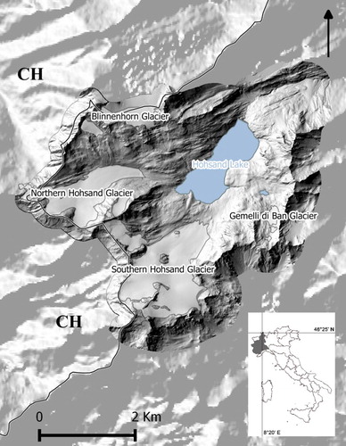
The presented work was carried out in the Hohsand Basin, a glacial catchment located in the northern Italian peninsula (46°25'N, 8°20'E) (). The investigated area is situated in the Formazza Valley (Lepontine Alps, Piemonte Region), across the boundary line with Switzerland. The study area has an overall extent of 18 km² and ranges in elevation from 2300 to 3374 m a.s.l. The basin is characterised by the presence of an artificially dammed lake of 1.23 km² (about 26 million m³ of maximum storage), built in the 1950s, and of the largest glacier area of Piemonte formed by two main mountain glaciers (Northern and Southern Hohsand Glaciers), of about 3.8 km² (Digital orthoimage year 2010, source: Ministero dell'Ambiente e della Tutela del Territorio e del Mare – Geoportale Nazionale, http://www.pcn.minambiente.it/GN).
Figure 1. Shaded relief map of the study area (DTM produced by Regione Piemonte, with 5 m cell size). Solid line: Italy–Switzerland cross border.
From a geological perspective, the basin is located in the Lower Penninic nappes, and is mainly characterised by orthogneiss (Monte Leone Nappe), in the southern sectors, and Cretaceous silica-carbonate rocks (metamorphosed in calceschists during the Paleogene, Valais Units), in the northern sectors; amphibolites and parasinites are also diffused in marginal zones of the study area (CitationRivella, Converso, & Nappi, 2012). About 60% of the area is covered by glaciers and outcropping bedrock, and the most widespread deposits are recent till with marginal ice-contact features such as frontal, lateral and hummocky moraines, dated to the Little Ice Age (LIA) and subsequent glacier evolution phases. The Hohsand catchment has a poorly developed soil structure and little vegetation with grasslands, mainly located on south-facing slopes, outside the LIA glacial maximum.
The Mean Annual Air Temperature is −0.9°C (Sabbione manned weather station, 1950÷2012), the coldest month is January (−8.0°C) and the warmest is August (7.2°C); the air temperature trends of Sabbione station indicate a significant (Mann-Kendall non-parametric test, assuming a 95% probability level, CitationSneyers, 1990, Citation1992) increase in maximum and minimum air temperatures, respectively of +0.03 ± 0.01°C year−1 and + 0.04 ± 0.01°C year−1. Total liquid annual precipitation is 1035 mm; annual average fresh snow and snow depth are 741 and 128 cm, respectively (CitationGiaccone, Colombo, Acquaotta, Paro, & Fratianni, 2015).
2.2. Data collection and elaboration
The cartographic products were produced using the following steps:
collection and analysis of technical and scientific literature available for the investigated basin;
preliminary aero-photographic interpretation (aerial images of the year 2000 and digital orthoimages of the year 2007) to produce a preparatory map for planning detailed field survey operations;
digitising of data derived from photographic interpretation (aerial images of the years 1955, 1977, 1983, 1989, 1999, 2001 and digital orthoimages of the years 1988–1989, 1994–1998, 2000, 2007, 2009, 2010); data were stored in a geographic information system (GIS) database (Coordinate System WGS 1984 UTM Zone 32N) using QuantumGIS (QGIS). Through this working phase the identification of periglacial/permafrost meso-landforms (rock glacier and protalus rampart) and the delineation of glacial limits (using the last available orthoimages of the year 2010) were performed;
collection and digitising of data derived from field surveys conducted during the summers 2012 and 2013 in order to identify glacial and periglacial ‘micro-landforms’ (e.g. frost boils, non-sorted stripes, stone-banked lobes). Several ground control points were acquired with a global positioning system (GPS) receiver for relevant geomorphological features;
assembling of deposits and landforms into different process units following genesis principles;
definition of a cartographic legend;
the base map (vector map, Carta Tecnica Regionale – in vector format at 1:10,000 scale) (Digital Terrain Model – DTM – produced by Regione Piemonte, with 5 m cell size);
production of geomorphological maps (Main Map at the scale 1:10,000 and high detailed sketches at 1:3,000) and a glacial deposits map (1:25,000) using QuantumGIS.
3. Results
In the Hohsand basin, glaciers are the principal morphogenetic agents, producing the most evident and extended morphostructures of the area. In particular, the erosive and depositional actions of the LIA glaciers (glacial maximum reached in the mid-1900s) have left typical and well-preserved deposits (till) and landforms (i.e. moraine ridges, roches moutonnèes and striated rock surfaces). These landforms are still visible, although masked by other associated and succeeding processes, linked to surface water erosion, mass movement and human action (e.g. dam lake creation and related infrastructure).
Regarding periglacial processes, 61 periglacial landforms were observed and mapped; 58% of these are gelifluction lobes, 39% are patterned ground and deposits remodelled by frost action (especially frost heave and frost sorting) and 3% are active rock glaciers and protalus ramparts. These periglacial landforms are mainly concentrated in three areas (Corno di Ban, Gemelli di Ban and Upper Blinnenhorn, shown in the three high-detailed sketches, Inset 1–3) and about 70% are located on LIA glacial deposits.
4. Conclusions
The analysis of landforms, deposits and morphogenetic processes of the study area was carried out through interpretation of aerial images and digital orthoimages, integrated with detailed field data collection. This integrated approach allowed production of the main geomorphological map at a scale of 1:10,000, high detailed sketches at 1:3,000 and a glacial deposit synthesis map at 1:25,000.
Geomorphological analyses and multitemporal photographic interpretation allowed us to gather detailed information about active morphological dynamics (i.e. recent evolution of active rock glaciers) mainly related to the transition from glacial to periglacial environments, demonstrating that the area has been characterised by intense short-term (several decades) morphological modifications due to its high sensitivity to climate change. In particular, after the shrinkage of glacial tongues and the general regression of glaciers since the end of the LIA, periglacial processes (with or without the presence of permafrost) have developed in progressively ice-free areas with genesis and evolution of typical cryospheric landforms (e.g. active rock glaciers, frost boils, patterned ground).
Finally, the remains of recent LIA glaciation and the large amount of periglacial meso- and micro-landforms identified within recently deglaciated sites in the Hohsand basin can be considered representative of the recent and ongoing climate evolution impacts on glaciers and periglacial environments in the Alps.
Disclosure statement
No potential conflict of interest was reported by the authors.
Software
Data processing and map production were completed in QGIS 1.9 (and following releases) and GRASS 6.4.
Geomorphology of the Hohsand basin (Western Italian Alps).pdf
Download PDF (85.9 MB)Additional information
Funding
References
- Acquaotta, F., & Fratianni, S. (2013). Analysis on long precipitation series in Piedmont (northwest Italy). American Journal of Climate Change, 2, 14–24. doi: 10.4236/ajcc.2013.21002
- Acquaotta, F., Fratianni, S., & Garzena, D. (2015). Temperature changes in the northwestern Italian Alps from 1961 to 2010. Theoretical and Applied Climatology, 122(3–4), 619–634. doi: 10.1007/s00704-014-1316-7
- Auer, I., Böhm, R., Jurkovic, A., Lipa, W., Orlik, A., Potzmann, R., Schoner, W., … Nieplova, E. (2007). HISTALP—historical instrumental climatological surface time series of the Greater Alpine Region. International Journal of Climatology, 27, 17–46. doi: 10.1002/joc.1377
- Ballantyne, C. (2002). Paraglacial geomorphology. Quaternary Science Reviews, 21, 1935–2017. doi: 10.1016/S0277-3791(02)00005-7
- Beniston, M. (2005). Mountain climates and climatic change: An overview of processes focusing on the European Alps. Pure and Applied Geophysics, 162, 1587–1606. doi: 10.1007/s00024-005-2684-9
- Benn, D. I., & Evans, D. J. A. (2010). Glaciers and glaciation. London: Hodder Education.
- Berthling, I., & Etzelmüller, B. (2011). The concept of cryo-conditioning in landscape evolution. Quaternary Research, 75(2), 378–384. doi: 10.1016/j.yqres.2010.12.011
- Böhm, R., Auer, I., Brunetti, M., Maugeri, M., Nanni, T., & Schöner, W. (2001). Regional temperature variability in the European Alps: 1760–1998 from homogenized instrumental time series. International Journal of Climatology, 21, 1779–1801. doi: 10.1002/joc.689
- Curry, A. M., Cleasby, V., & Zukowskyj, P. (2006). Paraglacial response of steep, sediment-mantled slopes to post-‘Little Ice Age’ glacier recession in the central Swiss Alps. Journal of Quaternary Science, 21(3), 211–225. doi: 10.1002/jqs.954
- Dobiński, W., Grabiec, M., & Gądek, B. (2011). Spatial relationship in interaction between glacier and permafrost in different mountainous environments of high and mid latitudes, based on GPR research. Geological Quarterly, 55(4), 375–388.
- EEA. (2009). Regional climate change and adaptation. (The Alps facing the challenge of changing water resources. EEA Report No. 8). Copenhagen: European Environment Agency.
- Etzelmüller, B., & Hagen, J. O. (2005). Cryospheric systems: Glaciers and permafrost. In C. Harris & J. B. Murton (Eds.), Glacier-permafrost interaction in arctic and alpine mountain environments – examples from southern Norway and Svalbard (242, pp. 11–27). London: Geological Society.
- French, H. (2007). The Periglacial environment. Chichester: John Wiley & Sons.
- Giaccone, E., Colombo, N., Acquaotta, F., Paro, L., & Fratianni, S. (2015). Climate variations in a high altitude alpine basin and their effects on glacial environment (Italian Western Alps). Atmósfera, 28(2), 117–128. doi: 10.1016/S0187-6236(15)30004-7
- Guglielmin, M., Cannone, N., & Dramis, F. (2001). Permafrost – Glacial evolution during the Holocene in the Italian Central Alps. Permafrost and Periglacial Processes, 12, 111–124. doi: 10.1002/ppp.379
- Haeberli, W., & Gruber, S. (2008). Mountain permafrost – Research challenges for steep and cold terrain. In D. L. Kane & K. M. Hinkel (Eds.), Proceedings of the 9th International Permafrost conference (pp. 597–605). Fairbanks, Alaska: Institute of Northern Engineering.
- Haeberli, W., Hoelzle, M., Paul, F., & Zemp, M. (2007). Integrated monitoring of mountain glaciers as key indicators of global climate change: The European Alps. Annals of Glaciology, 46, 150–160. doi: 10.3189/172756407782871512
- Hanson, S., & Hoelzle, M. (2004). The thermal regime of the active layer at the Murtèl rock glacier based on data from 2002. Permafrost and Periglacial Processes, 15, 273–282. doi: 10.1002/ppp.499
- Hoelzle, M., & Gruber, S. (2008). Borehole and ground surface temperatures and their relationship to meteorological conditions in the Swiss Alps. In D. L. Kane & K. M. Hinkel (Eds.), Proceedings of the 9th International Permafrost conference (pp. 723–728). Fairbanks, Alaska: Institute of Northern Engineering.
- Rivella, E., Converso, C., & Nappi, P. (Eds.) (2012). L'ambiente glaciale e periglaciale dei Sabbioni (Hohsand). Formazza: Progetto Biodiversità, Arpa Piemonte, Torino.
- Sneyers, R. (1990). On statistical analysis of series of observations. Technical note N. 143, World Meteorological Organization.
- Sneyers, R. (1992). Use and misuse of statistical methods for the detection of climate change. American meteorological society 12th conference on probability and statistics in the atmospheric sciences, Toronto, Canada.
- Terzago, S., Cremonini, R., Cassardo, C., & Fratianni, S. (2012). Analysis of snow precipitation in 2000–09 and evaluation of a MSG/SEVIRI snow cover algorithm in SW Italian Alps. Geografia Fisica e Dinamica Quaternaria, 35, 91–99.
- Terzago, S., Fratianni, S., & Cremonini, R. (2013). Winter precipitation in western Italian Alps (1926–2010): Trends and connections with the North Atlantic/Arctic oscillation. Meteorology and Atmospheric Physics, 119, 125–136. doi: 10.1007/s00703-012-0231-7