
ABSTRACT
We present a 1:10,000 scale geological map of Marettimo Island and its offshore (Egadi Archipelago, central Mediterranean Sea). The map was achieved by integrating a new geological survey with data from recent, marine, geological and geophysical surveys acquired along the adjacent continental shelf. The island is composed of a Mesozoic, mostly carbonate platform succession, which is overlain by continental to coastal marine Quaternary deposits. Extensional tectonics have affected the carbonate platform since the Late Triassic producing an initial increase of accommodation space that was filled by interbed breccias, marls and calcareous marls. During the Jurassic, a NE-SW-directed normal fault-bounded structural lows where thick beds of megabreccias accumulated followed upwards by cherty limestone and bedded cherts. During the building of the chain, the compressional tectonics generated a southeast-verging tectonic wedge, displaced by subsequent transpression. During the Quaternary, repeated sea-level changes shaped a rough erosional surface along the inner shelf and controlled the lateral facies variation of the continental and marine coastal deposits along the present day coastline.
1. Introduction
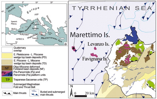
The stratigraphic and structural setting of the Marettimo Island (Italy) and its offshore are here illustrated with a detailed geological map at a scale of 1:10,000, based on an integrated sea–land geological/geophysical survey. Marettimo Island, belonging to the Egadi Archipelago and located in the western Sicily offshore (central Mediterranean Sea, (a)), represents the westernmost outcrop of the Sicilian Fold and Thrust Belt (FTB). A reliable understanding geological evolution of Marettimo Island, a natural bridge between the Sicilian and Tunisian sectors of the Apenninic–Maghrebian FTB (; see also the top-left regional map inset in the map), is a crucial contribution to the regional geological framework of the central Mediterranean. We also present the submerged coastal zone (up to −50 m) to continue and correlate outcropping and submerged geological features. In doing this, we note the stratigraphic relationships between continental and coastal marine sediments.
Figure 1. Structural map of western Sicily and its offshore area. (a) Location map showing the Egadi Islands in the context of the central Mediterranean area (modified from CitationCatalano et al., 2013).
2. Data and methods
The geological map of Marettimo is the result of a recent, detailed field survey reproduced at a scale of 1:10,000. The fieldwork included stratigraphic, sedimentary facies and meso-structural analyses. We integrated the field data with results of previous marine geological and geophysical surveys, performed in the framework of the CARG (Italian official Geological Cartography) and GEBEC Sud (CitationAgate, Catalano, Lo Iacono, & Chemello, 2005) projects.
The topographic basemap is the Section 604010, pertaining to the Carta Tecnica Regionale, at a scale of 1:10,000 (vector file format .dwg, plane coordinates of the East Zone of the Gauss-Boaga Italian national system geographical projection, datum Rome 1940, Monte Mario). The bathymetric basemap is Sheet 260 of the Istituto Idrografico della Marina, at a scale of 1:50,000. Both contour lines and isobaths are at a 10-m interval. To improve the legibility of the geological map, the topographic vector file was cleaned of some toponyms as well as cadastral and administrative boundaries.
The marine geological map results from the overlay of different information layers:
distribution of sediments based on different texture;
outcrops of the late Quaternary depositional sequence and the underlying lithostratigraphic units and
outcropping and buried tectonic lineaments.
3. Geological background
The geological setting of the Egadi Islands, located in the western Sicily offshore () is due to the collision between the Sardinia-Corsica micro-plate and the northern edge of the African continental margin, starting from the early Miocene (CitationBellon, Coulon, & Edel, 1977; CitationChannel, D'Argenio, & Horvath, 1979; CitationDercourt et al., 1986). From the Egadi Islands to Adventura Bank, the Sicilian FTB structural setting has been illustrated (CitationCatalano, D'Argenio, & Torelli, 1989; CitationSulli, 2000) as an eastward and southeastward verging, about 10 km-thick, tectonic stack made up of several tectonic units.
Marettimo Island represents the outcropping portion of a tectonic unit (Marettimo Unit) which overrides southeastward the Miocene sedimentary cover of the Favignana-Levanzo Unit (; CitationCatalano, Infuso, Milia, & Sulli, 1993); the latter is made up of the Meso-Cenozoic carbonate platform to pelagic seamount succession (Trapanese domain; CitationCatalano, Di Stefano, Sulli, & Vitale, 1996).
The structural model of Marettimo Island depicted by CitationHill and Hayward (1988) shows three main tectonic units stacked along flat surfaces. This model differs from those proposed by CitationGiunta and Liguori (1973) and CitationAbate, Incandela, and Renda (1999). The latter considered Marettimo Island as made-up of four tectonic units, settled during a late Miocene compressional event and a subsequent Pliocene NNE-SSW transpressive to transcurrent event.
4. Stratigraphy
The overall stratigraphic setting of the Island is characterized by middle-upper Triassic to lower Cretaceous carbonate rocks (Mesozoic succession) covered, along the coastal belt, by continental to marine Quaternary deposits.
4.1 The Mesozoic succession
On the whole, the stratigraphic succession is represented by : limestone, dolomitic limestone and dolomites (Marettimo Formation, middle-upper Triassic); dolomitic breccias and dolostones (Monte Falcone Formation, Lias); cherty limestone (Scaturro Formation, upper Lias–Dogger); bedded cherts, marls and marly limestone (Argilliti di Punta Troia, Malm–Lower Cretaceous). We distinguished two tectonic units (Falcone unit and Bassano unit, top to bottom) characterized by (slightly) different stratigraphic successions, named the ‘Falcone succession’ and ‘Bassano succession’ (Main Map).
Figure 2. Stratigraphic chart of the Marettimo Island succession and pictures of representative sedimentary facies. See text for details.
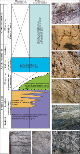
4.1.1 Stratigraphy of the Falcone succession
From the bottom, it is formed by:
Marettimo Formation: blackish bituminous stromatolites, stromatolitic limestone, blackish dolomitic limestone to dolomites rich in organic matter (MARa), microbial laminated fenestral limestone with tepee-like desiccation structures, oolitic limestone (MARd; (e)–(h)); yellowish to brownish thin layers of marls locally interbedded (MARb). This formation crops out along the eastern side of Monte Falcone and in the Pizzo Spirone area (Main Map).
Monte Falcone Formation (MFA) composed of three lithofacies with lateral and vertical transition:
massive limestone conglomerates (MFA1, cropping out at Punta Troia; (c); Main Map); the clasts, cobbles or boulders, are light grey to white stromatolitic limestone and laminated fenestral limestone;
breccias of shallow water dolomitic limestone, white to pinkish dolomites (MFA2, cropping out at Punta Troia; Main Map); poor rounded clasts of stromatolitic limestone and black microbial laminated limestone surrounded by dolomitic matrix;
well-stratified fine-grained dolomites, dolomitic limestone and dolomitic marls (MFA3, cropping out at Monte Falcone and Punta Bassano; Main Map).
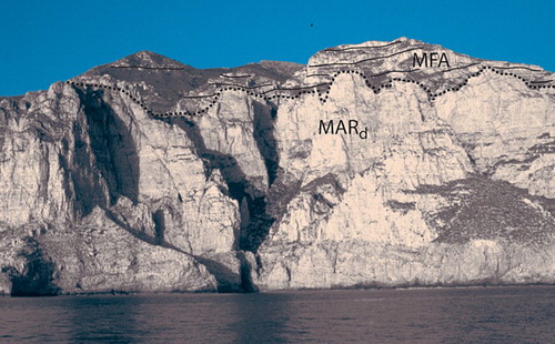
The Monte Falcone Formation overlies the Marettimo Formation along a widespread erosive unconformity ().
Scaturro Formation (PZS): light grey to white pelagic limestone with ammonoids, belemnoids and bivalves (Bositra sp.); chert nodules and bands are very abundant ((b)). These rocks rest on the Monte Falcone Formation along an unconformity and locally outcrop in the Punta Troia promontory and on the western side of Monte Falcone (Main Map).
Argilliti di Punta Troia (APT): reddish to greenish cherty marls, marly limestone, marls and radiolarites ((a)); thin-bedded carbonate turbidite sequences (Ta-c of Bouma), with chert nodules and layers frequently interbedded (APTa).
Figure 3. Unconformity surface among the Monte Falcone Formation (MFA3) and Marettimo Formation (MARd). Punta Bombarda, western coast of the island.
4.1.2 Stratigraphy of the Bassano succession
From the bottom, it is formed by:
Marettimo Formation (MARa): it shows the characteristics previously described, but yellow to brownish, thin-bedded marls and marly limestone are upward interbedded to the shallow-water limestone and dolomites ((d) and 2(e)). Their thickness notably increases along the Punta Bassano promontory (Main Map). Here, 140 m-thick marls, marly limestone, shelly limestone and dolomitic limestone are exposed. Intraformational breccias, with scour base, are frequently interbedded with the marly deposits (MARc). The elements are represented by centimetric, angular, shallow-water limestone, with enterolithic structures, surrounded by light brownish silt matrix (). The top of the Marettimo Formation is represented by a dark grey-laminated limestone and dolomitic limestone with fenestrae and tepee-like structures (MARc).
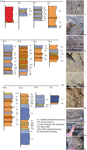
Figure 4. Stratigraphic log of the Conca succession (Marettimo Formation). See text for more detail.
Basaltic rocks were observed in the middle portion of MAR, along the Punta Bassano promontory and around the La Conca area.
This formation widely crops out along the eastern coast of the Island, along the Punta Bassano promontory and in the Punta Libeccio area.
Monte Falcone Formation: massive beds of fine-grained dolomite and dolomitic limestone outcropping at Punta Bassano (MFA3).
Scaturro Formation (PZS): shows the characteristics previously described. It crops out in the Punta Libeccio.
4.1.3 Stratigraphic sections
In order to better constrain the stratigraphic and structural setting, we analysed four representative stratigraphic sections:
Porto-Cimitero stratigraphic section: highlights the sedimentary features of the middle-upper part of the Marettimo Formation and its gradual transition to the marly interval;
Conca stratigraphic section: this allows understanding of the depositional environment and interaction between tectonics and eustasy;
Punta Libeccio stratigraphic section: this was analysed for the relationships between the lithostratigraphic units composing the Bassano succession and
Punta Troìa stratigraphic section: this displays the link between extensional tectonics and environmental changes.
The first three sections pertain to the Bassano Succession, the fourth to the Falcone Succession.
4.1.3.1 The Porto-Cimitero stratigraphic section
Along the coast from Marettimo village to Punta Bassano (Main Map), 130-m-thick shallow-water carbonates exhibit lithological variation upwards that indicate two main facies associations:
blackish bituminous stromatolites, dolomitic limestone and dolomites, algal laminites up to 1 m-bedded; they show fenestral porosity and desiccation structures as loferitic breccias and tepee-like structures ((e), 2(g) and 2(h)). At places, calcarenites and laminated limestone are intebedded. The outcropping thickness is 60 m;
stromatolites, dolomitic limestone and dolomites, algal laminites, interbedded with yellowish marls and yellow-blackish bituminous marly calcilutites; the thickness and frequency of marly intercalations increase upwards, and are predominant at the top. The thickness is up to 70 m.
4.1.3.2 The Conca stratigraphic section
Along the Punta Bassano headland (Main Map), 140-m-thick alternating carbonates, marly calcilutites and marls outcrop (MARb−c) are observed. The age is late Carnian – early Rhaetian. Based on composition, grain size, and fossils, we distinguished six main lithofacies ():
grey micritic limestone (CM), often dolomitized and organized in a thick layer with abundant pressure-solution stylolites; at places, pseudomorfs of gypsum are present;
laminated limestone (CL), laminated grey calcilutites, black recrystallized limestone with fenestral porosity, algal laminites with black bituminous loferitic breccias;
marly laminated limestone (CML), grey-yellowish and bituminuos in places, in centimetric thin-layered levels. Grey-yellowish thin-layered clayey marls (MA), with oligotipic ostracod faunas;
calcilutites and marly calcilutites with ‘lumachelle’ (C), grey-yellowish to hazel, with large shells (molluscs and brachiopods gastropods), whose casts and marks are evident above the stratal surfaces; they are interbedded with the marls in centimetric levels.
breccias and calcarenites (BC); they are 1-m-thick intraformational breccias composed of elements of laminated limestone and stromatolites with a yellowish marly matrix, becoming upwards coarse to fine calcarenites with evaporates levels.
very altered greenish basalts (ß).
4.1.3.3 The Punta Libeccio stratigraphic section
The Punta Libeccio stratigraphic section displays the Bassano succession with very low thickness. At Cala Nera (Main Map), grey-whitish to black bituminous limestone and dolomitic limestone, bearing algal laminites with fenestral porosity, desiccation structures and loferitic breccias (MARa), are organized in well-stratified beds; the thickness is not measureable being at the bottom and not outcropping. These rocks are overlain, throughout a reddish oxide-encrusted surface, by interbedded marls (MA), laminated marly limestone (CML), and laminated limestone (CL). This lithologic interval, here only 10-m thick, is correlated to the upper portion of the Marettimo Formation (MARb−c) outcropping along the Conca succession. The basal marly layers are very bituminous, decreasing upwards. At the top, tens of meters thick grey-whitish limestone, with black chert bands and nodules (Scaturro Formation) are well stratified in centimetric layers.
4.1.3.4 The Punta Troia stratigraphic section
Along the trail towards the top of the Punta Troia headland (Main Map), the Jurassic–Cretaceous succession of the Falcone Unit is outcropping.
At the base, a decametric interval of white-pink, in places hazel, Liassic massive dolomites and dolomitic breccias with elements of algal laminites, stromatolites and loferitic limestone, is considered the proximal portion of the Monte Falcone Formation (MFA1). They are uncomformably overlain by thick mega-conglomerates and breccias with m-thick elements of grey-white stromatolites, loferitic limestone and algal laminites (MFA2). Upper Liassic-Dogger grey limestone (Scaturro Formation, PZS) follow upwards above a buried boundary. At the top of the Punta Troia promontory, the MFA2 are bounded by an iron-encrusted surface. This hard ground is onlapped by red-green shales with radiolarians, silicified limestone and spongolitic marls (Argilliti di Punta Troia, APT), with 50 cm-thick layers of breccias, passing gradually from coarse to fine grey-yellowish calcarenites. The total thickness is 20–30 m.
4.2 Quaternary deposits
At the base of the steep carbonatic slopes of the northeastern coast of the island (Main Map), a continuous wedge of alluvial fans occur. Seaward, they show lateral facies variation into Pleistocene marine deposits lying discontinuously over the Mesozoic substratum.
4.2.1 Continental deposits
They are mainly grain-supported breccias and megabreccias, cemented or not, alternating with coarse sands with silty matrix, often reddish (DETa). The geometry and texture of these deposits are typical of alluvial fans with seaward-dipping clynoforms ((a) and 5(b)). We also found interbedded at different levels decimetric thick red palaeosols ((i) and 5(l)), made up of siltites and sandy clays with rare centimetric carbonatic clasts. A palaeosols layer separates the lower cemented carbonatic breccias and megabreccias (DETb) from the overlying red, not cemented levels (DETa; (d)), as shown along the trail from Punta Troia to Marettimo village, in the Punta Troia fan ((a)), near the cemetery, and close to the village.
Figure 5. Composite stratigraphic section showing architecture and geometry relationships between continental and littoral upper Quaternary deposits. See text for more detail.
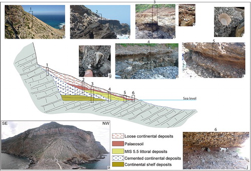
4.2.2 Marine coastal deposits
Between 0 and 10 m a. s.l., we found very thin levels of marine coastal deposits, composed of polygenic, grain-supported, fossil-bearing (mainly bivalves and gastropods) conglomerates ((e)). They pass upwards to micro-conglomerates and sands with reddish matrix and faunas (Patella ferruginea, Conus testudinarius (SIT); (f) and 5(g)) of the MIS 5.5 (Tyrrhenian).
At Punta Troia, at Case Martorana, along the coast between the village and the cemetery, and at Punta Galera (Main Map), a marine coastal wedge with Tyrrhenian fauna is interbedded between the cemented alluvial fan deposits and the overlying more recent not cemented continental deposits ((c) and 5(h)). On the shore near Molo Nuovo a yellow fossil-bearing calcarenitic layer underlies the older alluvial fan cemented deposit (MRS; (d)).
5. Marettimo offshore
The continental shelf off Marettimo Island is bounded by a sharp shelf-break located between 80 and 140 m of depth (Main Map); it displays an approximate rhombohedric shape in plan view that suggests structural control by NW-SE- and WNW-ESE-trending faults. The shelf is up to 13 km wide southwards but only 2–3 km wide off the western, northern and eastern coasts. This area is a very young, undernourished platform with a number of bathymetric breaks-of-slope and well-preserved morphological features such as palaeo-cliffs, rills and isolated relief (CitationLo Iacono, 2003).
The continental shelf is characterized by a widespread surface of marine erosion, scoured on the Meso-Cenozoic. This erosional surface, separating the Holocene from older rocks, has a polygenetic origin related to the last glacio-eustatic fluctuation that occurred in the last 100 ky.
Data from seismo-acoustic profiles and scuba-diving observation (www.videpi.com; CitationAgate et al., 2005; CitationCatalano et al., 1993; CitationHermand et al., 2000) allow the recognition of submerged outcrops of carbonate Mesozoic rocks (MAR, MFA) and terrigenous Oligo-Miocene rocks (FOR) unconformably covered by Plio-Pleistocene deposits (NO, ISD, OSD). Scattered patches of Holocene sediments unconformably overlie the Meso-Cenozoic rocks. They consist of mostly calcareous, very coarse to medium-sized sands with gravelly lithoclasts and bioclasts made up of algal nodules and skeletal grains (mostly bivalves, gastropods and bryozoans).
In the innermost sector of the continental shelf (0–20 m of water depth), a ring of the Mesozoic carbonate rocks outcrop on the very rough sea-bed, characterized by a number of several meter-high cliffs, at the base of which boulders, up to 20 m in size, have accumulated (CitationLo Iacono, 2003). Along the southern sector of the island, thin beds of the Marettimo Formation can be detected along the submerged coastal belt. Off the eastern coast, isolated carbonate relief of the Marettimo Formation outcrop at Scoglio del Cimitero and il Cammello. Wave cut platforms are very narrow, a few meters wide or totally absent.
On the whole, the coast shows bluff or cliff morphologies with only several very small pocket beaches. More vertical and higher (up to some tens of meters) cliffs coincide with the Monte Falcone Formation outcrops (e.g. Punta Bombarda, Punta Pegna).
6. Structural analysis
Currently, the Marettimo structural edifice can be described as a portion of a tectonic wedge, which consists of two tectonic units (Bassano unit and Falcone unit) characterized by a southeastward direction of transport.
Folding and faulting patterns were analysed at many sectors of the island (Main Map). The structural analysis, concerning bedding, axial plane stylolite cleavage, extensional veins, slickenlines and crystal fiber lineation, allowed recognition three different tectonic events and associated structures: the extensional, compressional and transpressional events.
6.1 Extensional event
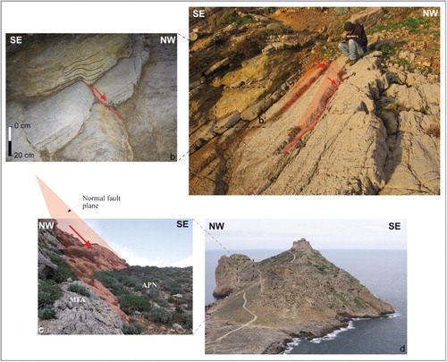
ENE-WSW normal faults, southwards-dipping and displaying local syntectonic geometries, affect the carbonate rocks of MAR, around the cemetery ((a) and 6(b)). On the Punta Troia promontory (Main Map), the Jurassic carbonates and dolomites of the Falcone Unit are displaced by high-angle ENE-WSW normal faults. The fault planes affecting the Liassic conglomerates and breccias (MFA1–2) are covered by the marls and radiolaria-bearing marly limestone (APT) along buttress unconformity surfaces ((c) and 6(d)). Another effect of the extensional stress field is the ENE–WSW alignment of basaltic rocks inside the Triassic marls of the Marettimo Formation (MARb) in the Bassano succession (Main Map).
Figure 6. (a) ENE-WSW syn-depositional normal fault; locally divergent stratal pattern is recognized in marly layers (b); Marettimo Formation, Cemetery locality. (c) ENE–WSW normal faults separating the Monte Falcone Formation (MFA; Lias) from the Argilliti di Punta Troia (APT; Malm – lower Cretaceous) along a buttress unconformity surface sensu CitationDavis and Reynolds (1996) cropping-out at Punta Troia promontory (d).
6.2 Compressional event
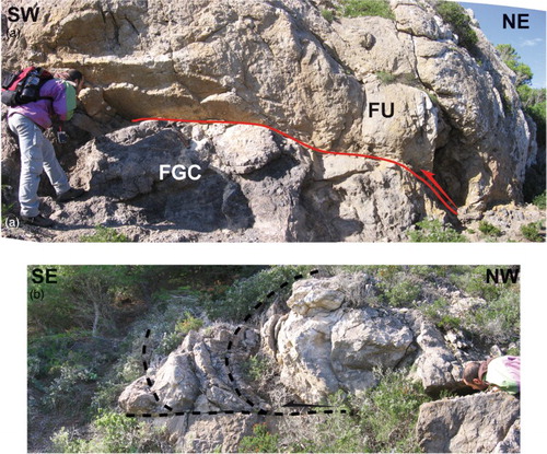
In the Pizzo Spirone area (Main Map), the Falcone unit thrusts over the Bassano Unit along a WNW- to NW-dipping fault plane; here, thrust faults are associated with fine-grained cataclasites ((a)). Towards the thrust forelimb, duplex structures and minor anticlines show a southeastward transport direction ((b)).
Figure 7. (a) Thrust fault (red line) close to the contact among the Falcone unit (FU) and the Bassano unit in the Pizzo Spirone area (FGC: Fine-Grained Cataclasites); (b) SE verging fold growing above a low-angle décollement surface recognized in the thrust fault hanging-wall (Falcone unit).
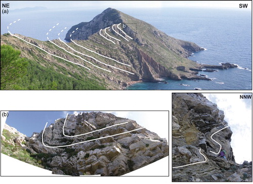
Along the Punta Bassano promontory, minor asymmetric folds with an ENE–WSW axis ((b)) in the Bassano Unit are associated with the reverse flank of a SE-verging syncline ((a)). Similar NE–SW asymmetric folds are also well exposed in the Posaturo. Symmetric folds compatible with a major syncline hinge zone are locally documented ((c)). The structural analysis evidences a major syncline, with NE-SW axis, compatible with the SE-verging thrust. The hinge zone of the syncline is partially cropping-out along the apparent monocline of Punta Bassano promontory (Main Map).
Figure 8. (a) The major syncline structure recognized along the Punta Bassano promontory; (b) and (c) minor folds compatible with a syncline hinge zone.
6.3. Transpressional event
NNW–SSE trending, right-lateral high-angle faults and cylindrical folds characterized by high-angle plunging document this tectonic event. The high-angle faults, with 0–30° slickenline rake, are compatible with a N–S σ1 orientation. The interference among the transpressional and the compressive inherited structures is also well documented. The most striking effect of this interference is the exhumation and re-deformation of the pre-existing tectonic structures. The hinge of the syncline structure ((a) and 8(b)) observed in the southern sector of the island (between the Posaturo and Conca area, Main Map) displays a clockwise rotation, while the axial plane is not much inclined and locally southward-dipping. On the Cala Marino side, a NNW–SSE dextral high-angle transpressive fault uplifted and re-deformed the syncline structure (see geological cross section in the Main Map).
7. Discussion and conclusions
7.1 Tectono-sedimentary evolution during the Mesozoic interval
Stratal pattern and facies analysis contributed to locating the Mesozoic Marettimo succession in a portion (which we propose to call the Marettimo domain) of the southern margin of the Tethyan ocean, characterized since the Triassic by a wide carbonate platform environment.
The middle-upper Triassic Marettimo formation deposited in a peritidal sector of a carbonate platform, which was controlled by SSE-ward dipping syn-sedimentary normal faults (). A very shallow-water domain characterized by algal mats ((g) and 2(h)) with evaporitic deposition was periodically flooded by high-energy normal water, forming scour base intraformational breccias (BC in ). Facies analysis points to a moderate-energy lagoonal environment with restricted circulation (see also CitationMartini, et al., 2007; C and MA in ). Shallow-water marls and marly limestone followed upwards.
Their thickness increases SEward (see Bassano succession vs. Falcone succession in ) in response to extensional tectonics, as supported by the slightly divergent stratal pattern.
The development of the tectonic subsidence, and the related dismembering of the carbonate platform margins continued up to the Malm-Early Cretaceous, as shown by the unconformity surface separating the Marettimo Formation from the Monte Falcone Formation () and the other stratigraphic features of the Falcone succession.
Normal faulting proceeded in the early Liassic (Falcone succession), leading to the thinning of the Jurassic platform and settling of the slope environment, with accumulation of a thick wedge of resedimented deposits ((c)). We consider the upper portion of the Falcone succession to be a slope-to-basin sequence (see stratigraphic columns in the Geological map). Liassic platform-derived clasts in the resedimented wedge of Punta Troia (MFA1–2), settled in a slope (periplatform talus or base-of-slope apron, CitationBosellini, 1991) close to a fault-bounded carbonate platform edge (CitationMullins & Neumann, 1979). The Dolomites and dolomitic marl alternations (MFA3) of the Falcone Formation accumulated in more distal areas.
During the late Liassic-Dogger, progressive deepening due to the extensional faults ((c)) accounted for widespread pelagic sedimentation, and cherty limestones (PZS) covering the slope deposits (MFA) or rests directly on the shallow-water limestone (MAR). During the Liassic-Dogger interval, the inner sectors of slope were undernourished and Fe–Mn oxy-hydroxide encrusted surfaces formed. These surfaces, considered an inherited rock ground (sensu CitationClari, Dela Pierre, & Martire, 1995), directly cover the inner slope conglomerates (MFA1), according to the Bahamian-type carbonate-slope bypass (CitationSchlager & Ginsburg, 1981).
During the Malm-Early Cretaceous, a hemipelagic environment was established, and respective deposits (Argilliti di Punta Troia, APT) covered, along a buttress unconformity (sensu CitationDavis and Reynolds, 1996; (c) and 6(d)), cherty limestones (PZS Formation), the encrusted surfaces and the conglomerates and breccias of the MFA Formation. The calcareous turbidites interbedded in the APT deposits around Punta Troia ((a)) indicate this sector close to be an active slope. The local buttress unconformity among the APT and their substrate demonstrates that the extensional tectonics were active up to the APT deposition.
7.2 Neogene to quaternary tectonic evolution
During the Miocene compressional event, the Marettimo domain was involved in the Sicilian-Maghrebian mountain building. Two main tectonic units (Bassano and Falcone Units) were stacked along a SE-verging thrust. The syncline along the Punta Bassano promontory is related to this deformation. The compressional structures reactivated often previous (Mesozoic) extensional faults. A subsequent transpressive tectonic event, characterized by NNW–SSE right-transpressive faults, displaced the older tectonic geometries and structures driving the Island to the present tectonic setting.
Sea-level changes that occurred in the middle-late Pleistocene, due to global climate change, have produced repeated oscillations of the shoreline position at intervals of about 100 and 20 ky. These shifts of the shoreline determined the periodic emergence and subsequent flooding of areas of continental shelf over which late Quaternary coastal deposits were in turn accumulated (during the rise of sea level) and dismantled (in whole or in part), during the lowering of sea level.
These oscillations of sea level and the related to shifting of the shoreline are the origin of vertical and lateral stacking of alternating marine and continental deposits around Marettimo Island () and well exposed in the Punta Troia area ((a)–(c)).
Because global sea-level curves reconstructed for the middle-late Pleistocene (CitationShackleton, 2000) suggest that sea level reached up to the Mediterranean platforms during highstand stages before the present day and were almost equal to or a few meters higher than the current level (CitationFerranti et al., 2006). Possible deviations of position of the last highstand littoral deposits from altitudes close to the present day sea level should be attributed to tectonic processes of uplift or subsidence.
In the Egadi Islands on the whole, including Marettimo Island, coastal deposits of Tyrrhenian age out crop at about 5–10 m above sea level (see also CitationAbate Buccheri, Renda, & Incandela, 1996; CitationAntonioli Renda, Silenzi, Verrubbi, & Parello, 1998), supporting the absence of tectonic vertical movement during the last 100 ky. Therefore, the uplift recorded by the continental shelf of Marettimo show that Plio-Pleistocene tectonics have stopped, or have significantly decelerated, since the Tyrrhenian (5e O2 isotopic stage).
Software
The geological map was compiled using Esri ArcGIS and Global Mapper, with additional refinement using Adobe Illustrator. Daisy 2.0 was used to produce the stereonet plots (CitationSalvini, 2001).
Sea-land Geology of Marettimo (Egadi Islands, central Mediterranean Sea).pdf
Download PDF (47.7 MB)Acknowledgments
We wish to thank J. Abraham, S. Corrado and M.R. Barchi for useful review of the manuscript.
Disclosure statement
No potential conflict of interest was reported by the authors.
Additional information
Funding
Related Research Data
References
- Abate, B., Buccheri, G., Renda, P., & Incandela, A. (1996). Le sezioni tirreniane delle località “La Conca” e P.ta Libeccio (Isola di Marettimo – Arcipelago delle Egadi, Sicilia NW). Indagine e paleoecologica bollettino della societa geologica italiana, 115, 145–158.
- Abate, B., Incandela, A., & Renda, P. (1999). Geologia dell'Isola di Marettimo. Naturalista Siciliano, XXIII(1–2), 3–41.
- Agate, M., Catalano, R., Lo Iacono C., & Chemello R., et al. (2005). Studio geologico, bionomico ed ecologico di aree marine protertte dell'Italia meridionale. Progetto GebecSud, Cluster 10 – Ambiente Marino, MIUR – CIPE, Dip. di Geologia e Geodesia, Università di Palermo, 274 pp.
- Antonioli, F., Renda, P., Silenzi, S., Verrubbi, V., & Parello, F. (1998). Ricostruzione dell'evoluzione paleo climatica e neotettonica di Marettimo durante gli stadi isotopici 5, 3 e 1. Atti del 79° congresso nazionale, Società Geologica Italiana, offset studio, Palermo, A, 82–85.
- Bellon, H., Coulon, C., & Edel, J. (1977). Le déplacement de la Sardaigne: Synthèse de données géochronologiques, magmatiques et paleomagnetiques. Bulletin de la Société géologique de France, 19, 825–831. doi: 10.2113/gssgfbull.S7-XIX.4.825
- Bosellini, A. (1991). Introduzione allo studio delle rocce carbonatiche (pp. 1–317). Ferrara: Bovolenta Editore.
- Catalano, R., D'Argenio, B., & Torelli, L. (1989). From Sardinia Channel to Sicily straits. A geologic section based on seismic and field data. In M. Bonafede, G. B. Piccardo, & G. B. Vai, et al. (Eds.), The Lithosphere in Italy. Advance in Earth Science Research (pp. 109–127). Roma: Accademia dei Lincei.
- Catalano, R., Infuso, S., Milia, A., & Sulli, A. (1993). The submerged Sicilian-Maghrebian chain along the Sardinia channel-Sicily straits belt. In M. D. Max & P. Colantoni (Eds.), Geological development of the Sicilian-Tunisian Platform. UNESCO report in Marine Science, (Vol. 58, pp. 43–48). Paris: UNESCO (DIT/AM).
- Catalano, R., Di Stefano, P., Sulli, A., & Vitale, F. P. (1996). Paleogeography and structure of the Central Mediterranean: Sicily and its offshore area. Tectonophysics, 260, 291–323. doi: 10.1016/0040-1951(95)00196-4
- Catalano, R., Valenti, V., Albanese, C., Accaino, F., Sulli, A., Tinivella, U., … Giustiniani, M. (2013). Sicily's fold/thrust belt and slab rollback: The SI.RI.PRO. seismic crustal transect. Journal of the Geological Society, London, 170, 451–464. doi: 10.1144/jgs2012-099
- Channel, J. E. T., D'Argenio, B., & Horvath, F. (1979). Adria, the African promontory, in Mesozoic Mediterranean paleogeography. Earth Science Review, 15, 213–292. doi: 10.1016/0012-8252(79)90083-7
- Clari, P. A., Dela Pierre, F., & Martire, L. (1995). Discontinuities in carbonate successions: identification, interpretation and classification of some Italian examples. Sedimentary Geology, 100, 97–121. doi: 10.1016/0037-0738(95)00113-1
- Davis, G. H., & Reynolds, S. J. (1996). Structural Geology. New York: Wiley and Sones.
- Dercourt, J., Zonenshain, L. P., Ricou, L. E., Kazmin, V. G., Le Pichon, X., Knipper, A. L., … Biju-Duval, B. (1986). Geologic evolution of the Tethys belt from the Atlantic to the Pamirs since the Lias. Tectonophysics, 123, 241–315. doi: 10.1016/0040-1951(86)90199-X
- Ferranti, L., Antonioli, F., Amorosi, A., Dai Prà, G., Mastronuzzi, G., Mauz, B., … Verrubbi, V., et al. (2006). Elevation of the last interglacial highstand in Italy: a benchmark of coastal tectonics. Quaternary International, 145–146, 30–54. doi: 10.1016/j.quaint.2005.07.009
- Giunta, G., & Liguori, V. (1973). Evoluzione paleotettonica della Sicilia Nord-Occidentale. Bollettino della Societa Entomologica Italiana, 92, 903–924.
- Hermand, J. P., Boni, P., Michelozzi, E., Guerrini, P., Agate, M., Borruso, A. … Scannavino, M. (2000). Geoacustic inversion with drifting buoys: en verse 1997/1998 experiments (Merettimo Is.). In A. Caiti, J. P. Hermand, S. M. Jesus, & M. B. Porter (Eds.), Experimentals acoustic inversion methods for exploration of the shallow water environment, (pp. 263–286). Dordrecht: Kluver Academic Publishers.
- Hill, K. C., & Hayward, A. B. (1988). Structural constraints on the Tertiary plate tectonic evolution of Italy. Marine and Petroleum Geology – 5.
- Lo Iacono, C. (2003). Aspetti geomorfologici, sedimentologici ed ecologici dell'offshore delle Isole Egadi. Tesi di dottorato di ricerca in “Geologia del sedimentario”. Università degli studi di Napoli “Federico II” e Università degli studi di Palermo, 1–158.
- Martini, R., Cirilli, S., Saurer, C., Abate, B., Ferruzza, G., &. Lo Cicero, G. (2007). Depositional environment and biofacies characterisation of the Triassic (Carnian to Rhaetian) carbonate succession of Punta Bassano (Marettimo Island, Sicily). Facies, 53, 389–400. doi: 10.1007/s10347-007-0115-3
- Mullins, H. T., & Neumann, A. C. (1979). Deep carbonate bank margin structure and sedimentation in the northern Bahamas. In L. J. Doyle, & O. H. Pilkey (Eds.), Geology of Continental Slopes (Vol. 28, pp. 165–192). Tulsa, OK: SEPM.
- Salvini, F. (2001). Daisy 2, version 2.44b. The structural data integrated analyzer [Free Software]. Dipartimento di Scienze Geologiche, Università degli Studi di ‘Roma3′, Rome.
- Schlager, W., & Ginsburg, R. N. (1981). Bahama carbonate platforms - the deep and the past. Marine Geology, 44, 1–24.
- Shackleton, N. J. (2000). The 100,000-Year Ice-Age Cycle Identified and Found to Lag Temperature, Carbon Dioxide, and Orbital Eccentricity. Science, 289, 1897–1902. doi: 10.1126/science.289.5486.1897
- Sulli, A. (2000). Structural framework and crustal characteristics of the Sardinia Channel Alpine transect in the central Mediterranean. Tectonophysics, 324, 321–336. doi: 10.1016/S0040-1951(00)00050-0