
ABSTRACT
The paper presents the visualisation of volcanic relief and processes that formed the landscape of the Nízký Jeseník Upland (today recognised as a national geopark) during different phases of the Cenozoic. There are three basic types of volcanic phenomena: (i) volcanoes, (ii) lava flows and changes of relief induced by them and (iii) tuffaceous sediments. These are presented by block diagrams, panoramic maps and cross-sections on 18 panels placed along a 25 km long education trail leading through the volcanic landscape. We used a combination of GIS and graphic software to produce block diagrams based on various published and unpublished information sources. The education trail transfers scientific knowledge to the general public in an effort to contribute to the educational objectives of the Jeseníky Geopark.
1. Introduction
Transferring scientific knowledge to the public is one of the goals of contemporary science, especially geosciences that study sites visited by tourists. One example of such promotion is the world network of Geoparks under the patronage of UNESCO (CitationMcKeever, Zouros, & Patzak, 2010). In addition to nature conservation, the aims of geoparks also include sustainable development, community involvement, nature sciences promotion, and informing and educating (CitationEder & Patzak, 2004; CitationMcKeever & Zouros, 2005). Public education is performed in several ways with education trails being very popular for in situ information on phenomena now and here (CitationDCR, 2010; CitationHarkins & Megalos, 2005). An education trail can be defined as a tourist trail (specially marked or based on an existing network of tracks) connecting information panels that are usually numbered. CitationHarkins and Megalos (2005) classify education trails by theme as general, conservation, soils and geology, water and wetlands, forest and ecology, wildlife observation and historical. The first education trail was created by F.E. Lutz in the Ramapo Mts near New York in 1925 as an ‘experiment about education in nature’. CitationLutz (1931) stated general principles for designing educational trails, for example, careful selection of presented topics, preferring visual education to long text or avoiding scientific names; these are still relevant. Modern trends for designing educational trails (CitationAmann, 2003) include interactivity (e.g. using quick response codes in order to link panels to a website with more information) or promoting activity (quizzes, practical tasks, etc.). The first education trail in the Czech Republic was created by Rudolf Kögler in 1941 near Krásná Lípa town along the geological fault dividing sandstones of the Bohemian Cretaceous Basin from the Lusatian Granite Massif. In the last decades, education trails have been understood as a way to present local heritage and have thus been supported via various forms of institutional financial cooperation. This has led to a boom in education trails. There are now more than 1000 education trails have been created in the Czech Republic (CitationGajdoš, 2015).
The design and creation of an education trail of volcanic relief and processes presented in this study was part of work dealing with the preparation and declaration of the Jeseníky National Geopark covering c. 3000 km2 in northern Moravia and Silesia, Czech Republic (CitationGeopark Jeseníky, 2015). The Nízký Jeseník Upland is important from a geological and geomorphological perspective. It reveals preserved volcanic features, including remains of volcanoes and lava flows. Information panels on the 25 km long Nízký Jeseník Volcanites Education Trail present various facts of the geological history of the landscape. The description includes pseudo-3D block diagrams, geological profiles, maps, photos and illustrations. The aim of the education trail is to introduce landforms, their evolution and historical consequences in an attractive and accessible way that is easy to understand. Focusing strictly on volcanic geology, the education trail is unique among the other education trails in the Czech Republic.
1.1. Study area
Nízký Jeseník is a large upland area situated in the north-eastern part of the Bohemian Massif in the Czech Republic, Central Europe ((a)) (CitationDemek & Mackovčin, 2006). It covers a total of 2894 km2 with a mean altitude of 483 m (CitationDemek & Mackovčin, 2006). The highest point, Slunečná, reaches 800 m a.s.l. The upland is generally composed of Palaeozoic/Lower Carboniferous flysch rocks (greywackes alternating with slate) that were formed in conjunction with the Variscan orogeny during which huge turbidity currents brought large amounts of sediment. These were deposited over older Devonian rocks (CitationChlupáč, Brzobohatý, Kovanda, & Stráník, 2011).
Figure 1. (a) Location of the education trail within the Czech Republic; (b) map of the education trail with the location of panels; (c) simplified geological map of the volcanic part of Nízký Jeseník (1 - neovolcanites, basalt; 2 - neovolcanites, basaltic tuffaceous sediments; 3 - Andělská hora Formation, mainly slate; 4 - Andělská hora Formation, greywackes; 5 - Horní Benešov Formation, greywackes; 6 Horní Benešov Formation, conglomerates; 7 - Devon, diabase rocks; 8 - Devon, limestones; 9 - Moravice Formation, slate).
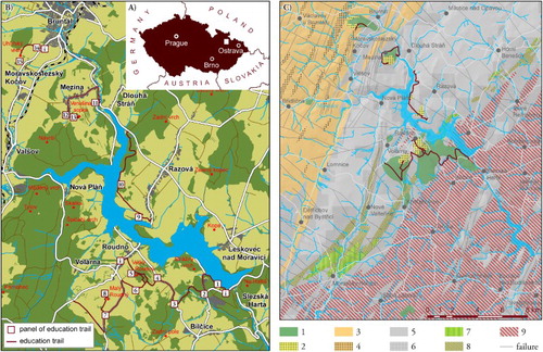
During different phases of the Cenozoic, several volcanoes, which belong to the youngest in the Czech Republic, broke through the Lower Carboniferous flysch rocks in the central part of Nízký Jeseník and formed impressive volcanic forms along the southeastern continuation of the Marginal Sudetic Fault ((b)) (CitationChlupáč, Brzobohatý, Kovanda, & Stráník, 2011).
CitationCajz, Skácelová, Schnabl, and Radoň (2013) recently studied samples of volcanic rocks (diverse compositions of olivine nephelinite to nepheline basanite) from several localities in Nízký Jeseník. They used K/Ar and palaeomagnetic dating in order to determine the phases of volcanic activity. Strombolian-type eruptions started in the Pliocene near Břidličná town. The volcano formed a huge cinder cone and there were most likely lava flows that led to the valley of the Moravice River. During the Early Pleistocene/Gelasian, a huge eruption led to the formation of the massif of Roudný Hill. Vast lava flows of the Roudný volcano covered the surrounding area. The longest lava flow probably extended 13 km to the south, terminating near Červená Hora Mt where small remnants have been preserved to this day (CitationCajz, Skácelová, Schnabl, & Radoň, 2013). However, previous studies considered the lava flows to be products of one volcanic centre (e.g. CitationBarth, 1977; CitationBarth & Kočandrle, 1979).
The north facing, nearly 5 km long, 900 m wide and up to 50 m thick lava flow of the Roudný volcano filled the valley of the Moravice River and caused the damming of the up to 600 m wide riverbed (CitationBarth, 1977; CitationBarth & Zapletal, 1978) over a length of 4 km (CitationCajz, Skácelová, Schnabl, & Radoň, 2013). This event brought about the formation of a temporary lake where tuffaceous sediments deposited in outlying bays. The subhorizontal strata contain pyroclastic material from the Roudný volcano as well as material eroded from older lava flows of the Břidličná volcano mixed with gravitationally redeposited angular conglomerate clasts of sedimentary flysch rocks. Currently, the tuffaceous strata are exposed in several quarries.
The original huge volcano was worn down during the rest of the Quaternary and divided by erosion into two separate elevations: the Velký Roudný Hill (780 m a.s.l.) and the Malý Roudný Hill (771 m a.s.l.). In previous studies, these elevations were considered to be two separate volcanoes (e.g. CitationBarth, 1974, Citation1977). The remnants of lava flows overlying Early Pleistocene river terraces started to be gravitationally released after the re-incision of the Moravice River (CitationHorský, Műller, & Trávníček, 1972).
Minor eruptions of at least two other volcanoes (Venušina sopka, 654 m a.s.l. and Uhlířský vrch, 672 m a.s.l.) occurred in the Early Pleistocene/Calabrian. Both the elevations are formed of volcanic cones whose upper part is pyroclastic. The eruption of Uhlířský vrch was rather calm, whereas the eruption of Venušina sopka was quite strong, as demonstrated by the findings of sizable volcanic bombs (Ø 1 m), xenolithes and scoria (CitationBarth, 1977; CitationCajz, Skácelová, Schnabl, & Radoň, 2013; CitationChlupáč, Brzobohatý, Kovanda, & Stráník, 2011). One of the lava flows of Venušina sopka has been exposed in the quarry near Mezina Village, where pentagonal and hexagonal jointing of basalt is protected as a natural monument. The southern slopes of Uhlířský vrch were exposed thanks to tuff quarries in the nineteenth century.
2. Methods
Information sources for the preparation of particular panels included the combination of published (e.g. CitationBarth & Zapletal, 1978; CitationChlupáč, Brzobohatý, Kovanda, & Stráník, 2011; CitationCzudek, 1988; CitationEliáš, 1962; CitationJanoška, 2001; CitationŠalanský, 2004; CitationZimák, 1995) and unpublished work (mainly archival materials of geological research, drilling profiles, mining documentation, post-mining reclamation reports) summarised by CitationOrdánová (2011). In general, there are three basic types of phenomena: (i) volcanoes, (ii) lava flows and changes of relief induced by them and (iii) tuffaceous sediments. From this wider perspective (), localities presented by the panels of the education trail were selected according to their value along with their accessibility and potential for planning a logical tourist path ((c)).
Table 1. Evaluation of the education trail potential localities. Modified after CitationOrdánová (2011).
Panel design () is unified by (i) frame with title, number, and imprint, (ii) maps of the education trail (one general map at 1:135,000 scale and one detailed map at 1:40,000 scale) and (iii) geological map of the locality and (iv) information box with an explanation of scientific terms used in texts. Another unifying feature is the main colour (CMYK 30-100-90-40) representing both lava and the colour of volcanic features on standard geomorphological maps (CitationDemek & Embleton, 1972).
Figure 2. Education trail panel design and basic features: (a) panel number and name; (b) volcano silhouette and panel frame; (c) overview map of the education trail; (d) detailed map of a part of the education trail; (e) information box with the explanation of the scientific terms used on a panel; and (f) simplified geological map with volcanic features.
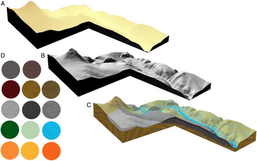
The main feature of all the panels are block diagrams that are based on a digital elevation model (DEM) generated from contours with a 2 m interval in Esri ArcGIS. The DEM with a 4 m × 4 m cell size was visualised with 3× vertical exaggeration using Golden Software Surfer. Two separate layers were exported for each block diagram from Surfer: base heights and shaded relief ((a),(b)). These layers were processed in Adobe Photoshop using various tools (brush colouring; layer effects such as bevel and emboss, glows and shadows; transparency of layers and blending of settings) for the final block diagram ((c)). We used own standardised colours and textures ((d)) of common features like bedrock, water or lava flows. The same method (DEM from ArcGIS – visualisation in Surfer – painting and finishing in Photoshop) was used also for the panoramic maps featured in the introductory panels; the angle of view for each panoramic map is individual according to its location. For the visualisation of changes of the relief induced by volcanic processes, we created a contour image of the assumed landscape form (based on research and terrain data) for each stage prior to DEM generation. The final design of the panels (including text, figures, photographs, block diagrams, profiles, etc.) was created in Adobe InDesign; the original size of each panel is 100 cm × 60 cm.
Figure 3. (a) Input base-heights block diagram layer; (b) input shaded relief block diagram layer; (c) final block diagram with coloured and overlay layers; and (d) used textures and colours palette.
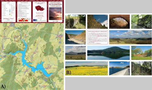
In addition, a tourist map at 1:35,000 scale was created ().
Figure 4. Touristic map (1:35,000) of the education trail: (a) front and (b) reverse side.
3. Results: panels, maps and block diagrams
The total length of the education trail is 25 km. Divided into four parts ((c)), it contains 15 thematic (13 currently completed) and 3 introductory panels ( and ). In order to illustrate the phenomena of the education trail, we present one panoramic map and four panels/localities in this paper (see the Main Map).
Figure 5. Overview of education trail panels: (a) introductory panels with panoramic maps and (b) thematic panels.
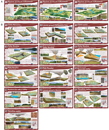
Table 2. List of panels and their content.
3.1. Chřibský lava flow
The Chřibský lava flow is the longest and best investigated lava flow in the region, with an open-cast mine revealing its history through geological profiles. The lava flow was formed by two subsequent effusion processes dated by CitationŠibrava and Havlíček (1980) to 1.46 and 1.28 Ma, respectively. However, other studies (e.g. CitationCajz, Skácelová, Schnabl, & Radoň, 2013; CitationPécskay, Přichystal, Tomek, & Zapletal, 2009) have different dating results. The main feature of the panel is a block diagram of the lava flow showing its extent. In 1998 the base of the lava flow was flooded by the Slezská Harta dam. Several pseudo-3D profiles show the structure of the lava flow with parameters for each lava effusion site. The block diagram and profiles are based on the studies of CitationEliáš (1962) and CitationBarth (1977). Today, the contact between the effusions is visible within the basalt open-cast mine. Nevertheless, the mine is still in operation and thus inaccessible to the public. Pictures and text of the panel also explain different kinds of basalt jointing and its genesis.
3.2. Razovské tuffaceous sediments
The Razovské tufity abandoned quarry is one of the places where tuffaceous sediments are exposed (according to CitationWeissmanová (2004), the outcrop area is c. 0.21 km2). A 12 m thick layer of tuffaceous sediments (partly mixed with debris) were deposited during the existence of a temporary lake created by the damming of the Moravice River valley by the lava flows of the Velký Roudný volcano. The natural dam, whose extent and topographic situation was reconstructed based on drilling and profiles described by CitationBarth and Zapletal (1978), and the eruption of the volcano are presented in the first block diagram, while the present situation with the stratigraphic profile is illustrated in the second block diagram. Tuffaceous sediments have been mined here since the Middle Ages. The inactive quarry with c. 5 m high quarry faces was declared a Natural Monument in 1997 in order to protect both the geology and thermophilic flora of the site (CitationWeissmanová, 2004).
3.3. Velký Roudný volcano
Of the Nízký Jeseník volcanoes, Velký Roudný is the highest and best preserved, topped with a shallow depression considered to be the eroded remains of a crater. Both lava and pyroclastic sediments (e.g. ash, lapilli, scoria and volcanic bombs) are observed on slopes of the hill. The block diagram of the panel shows a simplified scheme of the volcano structure with the conduit, rock layers, craters and lava flows. The reconstruction is based on the geological research by CitationKettner (1952), CitationFrejková (1952) and CitationBarth (1977), and geomorphological mapping by CitationFriedrich (2006). The magma chamber and the process of eruption are described on another panel in more detail.
3.4. Moravice valley and its pre-volcanic course
The course of the Moravice River changed due to lava effusion that had filled the Early Pleistocene valley, damming and forcing the river to incise a new valley to the north-east of the old one. These processes are described in three block diagrams: the first one shows the former valley during the earliest eruptions, the second one shows the dam behind lava flows, and the third one presents the post-volcanic situation prior to Slezská Harta dam construction. The topography of previous stages of landscape evolution, including the extent of the natural dam lake, was reconstructed on the basis of work by CitationBarth and Zapletal (1978).
4. Conclusion
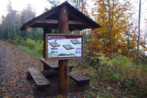
Unlike other components of the landscape, geological and geomorphological changes are often hidden from people's view: not only because of their underground character, but also unimaginable portions of time necessary for the formation of landforms. Panels of the presented education trail are focused on volcanic processes that formed the central part of the Nízký Jeseník Upland millions of years ago. Some of the volcanic landforms are dominant in the contemporary landscape (e.g. Velký and Malý Roudný volcanoes) or they played an important role in landscape formation. However, their significance is not clear to the general public. For this reason, we introduced the geological history mainly in the form of block diagrams that show cross-sections through volcanoes and lava flows, particular stages of relief development or processes leading to the deposition of sediment layers, now exposed in several old quarries. Creation of these panels required the study of various information resources (including unpublished archival materials accessible only with difficulty), their integration and the modelling of previous stages of landscape processes. The data were visualised using a combination of GIS and graphic software to create uncomplicated, but apt illustrations that introduce the present scientific knowledge to a broad public. Located close to the described landforms (), the education trail panels enable an easy comparison of real landscape with the description of its history and evolution. As an important contribution to the educational objectives of the Jeseníky Geopark, the presented education trail also represents a new tourist attraction for the region.
Figure 6. One of the panels of the education trail (photo: D. Friedrich).
Software
Block diagrams and panoramic maps were created using a combination of Esri ArcGIS, Golden Software SURFER and Adobe Photoshop. Maps were created in Esri ArcGIS and adjusted in Adobe InDesign. Panels of the education trail were designed in Adobe InDesign.
Visualisation of Volcanic Relief and Processes: the Nízký Jeseník Upland Educational Trail, Czech Republic.pdf
Download PDF (5 MB)Acknowledgements
The education trail project was created by Daniel Friedrich. The authors would like to thank Monika Hradecká for language editing.
Disclosure statement
No potential conflict of interest was reported by the authors.
ORCID
Jan Miklín http://orcid.org/0000-0002-0125-2539
Additional information
Funding
References
- Amann, M. (2003). Pojďme na to od lesa: Příručka ekologické výchovy a lesní pedagogiky [Let´s start in the forest: A guide to ecological education and forest pedagogy]. Vimperk: Správa NP a CHKO Šumava.
- Barth, V. (1974). Die Basaltvulkane in der Umgebung von Roudno im Nízký Jeseník-Gebirge [The basalt volcanoes around Roudno in the Nizký Jesenik Mts.]. Acta Universitatis Palackianae Olomucensis, 46, 5–15.
- Barth, V. (1977). Čedičové vulkány střední části Nízkého Jeseníku [Bazalt volcanoes in the central part of the Nízký Jeseník Mts]. Časopis pro mineralogii a geologii, 22, 279–291.
- Barth, V., & Kočandrle, J. (1979). Čedičové výskyty u Břidličné, Staré Libavé a Křišťanovic v Nízkém Jeseníku [Basalt occurrence near Břidličná, Stará Libavá and Křišťanovice in Nízký Jeseník]. Acta Universitatis Palackianae Olomucensis, Geography–Geology, 62, 25–53.
- Barth, V., & Zapletal, J. (1978). Geologie razovského pyroklastického komplexu v Nízkém Jeseníku [Geology of the Razová pyroclastic complex in the Nízký Jeseník Mts]. Sborník geologických věd – Journal of Geological Sciences, 32, 97–122.
- Cajz, V., Skácelová, Z., Schnabl, P., & Radoň, M. (2013). Svrchněkenozoický severomoravský vulkanizmus: rekonstrukce činnosti, paleomagnetizmus, geofyzikální obraz, návrh litostratigrafie [Upper Cenozoic volcanic activity in Northern Moravia: Reconstruction, palaeomagnetism, geophysical image, proposal of litostratigraphy]. Zprávy o geologických výzkumech v roce, 2012, 20–25.
- Chlupáč, I., Brzobohatý, R., Kovanda, J., & Stráník, Z. (2011). Geologická minulost České republiky [Geological past of the Czech Republic]. Prague: Academia.
- Czudek, T. (1988). Údolí Nízkého Jeseníku [Valley of Nízký Jeseník]. Prague: Academia.
- DCR. (2010). Trails guidelines and best practices manual. Boston, MA: Department of Conservation and Recreation. Retrieved July 22, 2015, from http://atfiles.org/files/pdf/MAtrailguidelines.pdf
- Demek, J., & Embleton, C. (Eds.). (1972). Guide to medium-scale geomorphological mapping. Brno: IGU Comission on Geomorphological Survey and Mapping.
- Demek, J., & Mackovčin, P. (Eds.) (2006). Zeměpisný lexikon České republiky: hory a nížiny [Geographical lexicon of Czech Republic: Mountains and lowlands]. Brno: Agentura ochrany přírody a krajiny České republiky.
- Eder, F. W., & Patzak, M. (2004). Geoparks – geological attractions: A tool for public education, recreation and sustainable economic development. Episodes, 27, 162–164. Retrieved July 02, 2015, from http://www.episodes.co.in/index.php/epi/article/download/62384/48655
- Eliáš, M. (1962). Čedičová formace Nízkého Jeseníku [Basalt formation of Nízký Jeseník]. In Z. Roth (Ed.), Vysvětlivky k přehledné geologické mapě ČSSR 1: 200 000: M-33-XXIV Olomouc [Comments to the geological map of the Czechoslovak Socialistic Republic 1: 200,000, part M-33-XXIV Olomouc] (pp. 45–51). Prague: Československá akademie věd.
- Frejková, L. (1952). Příspěvek k poznání moravskoslezských sopek Nízkého Jeseníku [Contribution to knowledge of Moravian-Silesian volcanoes of Nízký Jeseník]. Přírodovědecký sborník Ostravského kraje: Čtvrtletník Slezského studijního ústavu pro přírodní vědy, 13, s. 315– s. 334.
- Friedrich, D. (2006). Reliéf Velkého a Malého Roudného: Geomorfologické mapování [Relief of Velký and Malý Roudný: Geomorphological mapping] (Unpublished master thesis). University of Ostrava.
- Gajdoš, P. (2015). Naučné stezky v České republice [Education trails in the Czech Republic]. Retrieved June 13, 2015, from http://www.stezky.unas.cz/index2ns.htm
- Geopark Jeseníky. (2015). Geopark Jeseníky [Jeseníky Geopark]. Retrieved July 14, 2015, from http://www.geoparkjeseniky.cz/
- Harkins, L., & Megalos, M. A. (2005). Recreational forest trails: Plan for success. Raleigh: North Carolina State University. Retrieved July 14, 2015, from http://content.ces.ncsu.edu/recreational-forest-trails-plan-for-success.pdf
- Horský, O., Műller, K., & Trávníček, L. (1972). Průzkum porušení čedičového příkrovu v přehradním místě Slezská Harta geologicko-geofyzikálními methodami [Geological–geophysical research of the disruption of the bazaltic nappe in the Slezská Harta dam site]. Sbor. geol. Věd, Hydrogeol. inž.Geol., 10, 39–57.
- Janoška, M. (2001). Nízký Jeseník očima geologa [Nízký Jeseník by eyes of a geologist]. Olomouc: Palacký University.
- Kettner, R. (1952). Zpráva o geologickém mapování v okolí Horního Benešova a Leskovce v Nízkém Jeseníku [Report on geological mapping in the surroundings of Horní Benešov and Leskovec in Nízký Jeseník mts.]. Věstn. Ústř. Úst. geol., 27, 149–155.
- Lutz, F. E. (1931). Nature trails: An experiment in out-door education. New York, NY: The American Museum of Natural History.
- McKeever, P. J., & Zouros, N. (2005). Geoparks: Celebrating earth heritage, sustaining local communities. Episodes, 28, 274–278. Retrieved June 23, 2015, from http://www.episodes.co.in/index.php/epi/article/viewFile/62344/48622
- McKeever, P. J., Zouros, N., & Patzak, M. (2010). The UNESCO global network of national geoparks. Retrieved June 23, 2015, from: http://www.georgewright.org/271mckeever.pdf
- Ordánová, Š. (2011). Geopark ve střední části Nízkého Jeseníku [Geopark in the middle part of the Nízký Jeseník Mts] (Unpublished master thesis). University of Ostrava.
- Pécskay, Z., Přichystal, A., Tomek, Č., & Zapletal, J. (2009). Nová radiometrická data pro neovulkanity severní Moravy a Slezska [New radiometrics data for neovolcanites of Moravia and Silesia]. In M. Faměra, Z. Dolníček, & T. Lehotský (Eds.), Moravskoslezské paleozoikum 2009 – sborník abstraktů [Moravian–Silesian Paleosoic 2009 – conference proceedings]. Olomouc: Palacký University. Retrieved July 08, 2015, from: http://www.geology.upol.cz/Soubory/2009_Famera_Dolnicek_Lehotsky_Sbornik_Moravske_Paleozoikum.pdf
- Šalanský, K. (2004). Neovulkanity České republiky a jejich geofyzikální projevy [Neovolcanites of the Czech Republic and their geophysical characteristics]. Prague: Czech Geological Survey.
- Šibrava, V., & Havlíček, P. (1980). Radiometric age of Pli-Pleistocene volcanic rocks of the Bohemian Massif. Věstník ÚÚG, 55, 129–139.
- Weissmanová, H. (2004). Chráněná území ČR X.: Ostravsko [Protected areas of the Czech Republic X.: Ostrava region]. Praha: Agentura ochrany přírody a krajiny.
- Zimák, J. (1995). Průvodce ke geologickým exkurzím: Střední a severní Morava, Slezsko [Geological excursion guide: Central and Northern Moravia, Silesia]. Olomouc: University of Palacký.