
ABSTRACT
A 1:18,000-scale geomorphological map of the Lower Calore River alluvial plain (Southern Italy) is here presented. The area strongly suffered the dramatic effects of a destructive flood on 15 October 2015. The presented Map was produced in a GIS using topographic maps dating from 1870, 1909, 1936 and 1955 and 1:10,000-scaled colour orthophotos from 1998. All the maps and aerial photos were georeferenced in the UTM33 WGS84 coordinate system. The detected landforms were manually digitized and checked in the field. A geodatabase containing attributes such as type, age and surface area of each landform was created and progressively updated. The areal and unconventional map legend was designed to provide maximum readability. In the alluvial plain, five orders of river terraces were recognized. They are separated by strongly reshaped, gently sloping, inactive fluvial scarps (FS), less than 1.5 m high. Former channels, now abandoned, were also mapped. The confluence migrated eastward/east-northeastward between 1870 and 1955, followed by a north-northwestward migration between 1955 and 1998. Finally, numerous riverbank failures were observed and mapped along the active FS. A secondary map showing the age of the alluvial plain was also produced and showed that most of the investigated alluvial plain formed between 1909 and 1936. The study also shows the results of channel adjustments experienced by the river in ∼130 years.
1. Introduction
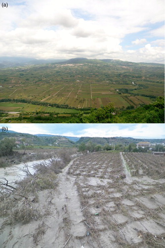
Italian rivers underwent marked channel adjustments in the last century, mainly consisting of incision and narrowing (CitationSurian et al., 2009; CitationSurian & Rinaldi, 2003). In particular, the Calore River (Southern Italy) experienced a mean narrowing of 66% (with a peak of 86%) and an incision of the order of 3–4 m between 1955 and 1998 (CitationMagliulo, Valente, & Cartojan, 2013). Most researchers suggest human disturbances such as gravel mining, river damming, channelization, floodplain alterations and land-cover and land-use changes in the basin as the main causes of medium- and short-term channel adjustments (CitationGregory, 2006; CitationHooke, 2006; CitationPiacentini, Urbano, Sciarra, Schipani, & Miccadei, 2015; CitationSurian et al., 2009; CitationSurian & Rinaldi, 2003). These factors act together with natural control factors, such as climate change (CitationKnox, 1993; CitationRădoane, Obreja, Cristea, & Mihailă, 2013; CitationStarkel, 2002). Generally speaking, channel adjustments are shown by landforms detectable in the surrounding alluvial plain, such as river terraces, abandoned channels (ACs) and inactive fluvial scarps (FS). Geomorphological maps graphically represent the extent, type, age and spatial distribution of these landforms. In modern geomorphological mapping, classical geomorphological maps have been generally replaced by digital, geographical information system (GIS)-based information layers that are linked to attributes and stored in a geodatabase (CitationGuerriero et al., 2013; CitationOtto, Geilhausen, & Gustavsson, 2011; CitationSeijmonsbergen, 2013). In Italy, almost all the new edited geomorphological maps are GIS-based. For example, those produced by Regional and Provincial Cartographic Authorities (e.g. CitationBondesan, 2015; CitationBondesan, Meneghel, Rosselli, & Vitturi, 2004) and by the new planning authority, such as Piani di Assetto del Territorio (e.g. http://www.regione.veneto.it/web/ambiente-e-territorio/pat; accessed 26 October 2015) and Piani Territoriali Provinciali (e.g. http://www.ptrc.it/ita/cartografia-ambiente-veneto-tavolo-coordinamento-ptcp.php; accessed 26 October 2015). In fluvial environments, the use of GIS in geomorphological mapping can facilitate, amongst others, quantifying river form, processes and rates of morphological change and is a key starting point to assess fluvial hazards and risks (CitationNapieralski, Barr, Kamp, & Kervyn, 2013; CitationO'Connor, Jones, & Haluska, 2002). Despite this, few examples of GIS-based geomorphological maps of Italian alluvial plains were found in literature (CitationFurlanetto & Bondesan, 2015; CitationGioia, Sabato, Spalluto, & Tropeano, 2011; CitationPiacentini et al., 2015; CitationRosskopf & Scorpio, 2013; CitationValente & Magliulo, 2012). To contribute to reducing this gap, a GIS-based geomorphological map of the Lower Calore River alluvial plain (Italy) is presented here (see Main Map; ). The map provides data about the type, spatial distribution and age of alluvial plain landforms shaped by channel adjustments experienced by the river over 128 years, with the purpose of obtaining information about the short-term morpho-evolutionary trend of the Calore River in this sector. The Lower Calore River alluvial plain is also intensely developed, as geomorphological land surfaces are exploited for agriculture and sediment extraction particularly where they are very close to the current active channel ((a)). Thus, the economy of the area suffered the disastrous effects of the destructive flood that occurred on 15 October 2015 ((b)). A heavy rainfall event of more than 140 mm in ∼5 h led to an increase in the water level by more than 8 m and caused about €1 billion damages to local agriculture. In areas such as this, an accurate assessment of flood hazard and risk is obviously of great importance. Thus, geomorphological mapping of the alluvial plain, such as the one carried out in this study, can be a fundamental starting point in such assessments (CitationNapieralski et al., 2103).
Figure 1. Location and lithology of the Lower Calore River Basin. (a) slope deposits (Holocene); (b) alluvial deposits (Holocene); (c) pyroclastic deposits (Upper Pleistocene-Holocene); (d) travertine (Upper Pleistocene-Holocene); (e) alluvial deposits (Upper Pleistocene); (f) alluvial deposits (Middle Pleistocene); (g) alluvial fan deposits (Middle Pleistocene); (h) slope deposits (Lower-Middle Pleistocene); (i) terrigenous deposits (Miocene-Pliocene); (l) calcareous rocks (Jurassic-Eocene).
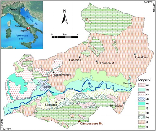
Figure 2. (a) Overview of the central sector of the Lower Calore River alluvial plain. Note the intense exploitation of the plain for agriculture and the proximity of cultivated land to the current active channel; (b) effects of the disastrous flood of 15 October 2015.
2. Study area
The Calore River is the main left tributary of the Volturno River. The total length is approximately 110 km and the mean annual discharge, measured at the confluence into the Volturno River, is about 30 m3/sec. The Calore River basin is about 3050 km2 wide and is located within the axis of the Campanian sector of the Southern Apennines fold-and-thrust belt, which is the result of compressional tectonics mainly active during the Tertiary (CitationPatacca & Scandone, 2007). The valley pattern of the Calore River is strongly controlled by tectonics, as highlighted by the four subsequent segments forming at 90° angles to each other (CitationMagliulo, Russo, & Valente, 2007).
The Lower Calore River corresponds to approximately the last 30 km of the watercourse. The basin is ∼252 km2 wide and is also known as the Telesina Valley. The bedrock mainly consists of Tertiary-aged terrigenous deposits and, subordinately, of calcareous rocks, Jurassic to Eocene in age (). Terrigenous deposits mainly crop out in the northern part of the valley and consist of sandstones, clays and marls of the Molise-Sannio-Lagonegro pelagic basin successions (CitationMostardini & Merlini, 1986). Calcareous rocks crop out at both the far northern sector of the valley, where they consist of Eocene-aged calcarenites and calcilutites, and the southern sector, where they consist of limestone, Jurassic to Cretaceous in age (CitationBergomi, Manfredini, & Martelli, 1975). Such tectonically deformed substratum is unconformably overlain by Quaternary-aged alluvial, slope and pyroclastic deposits. The oldest consist of cemented calcareous breccias, tentatively dated to the Lower-Middle Pleistocene (CitationBergomi et al., 1975; CitationMagliulo, 2005), unconformably overlain by Middle Pleistocene alluvial fan deposits, made up of poorly sorted, subangular calcareous pebbles in a silty-sandy matrix. Alluvial fan deposits are interfingered with fluvial and fluvio-lacustrine sediments of the Calore River, consisting of gravels and sands with silty-clayey interbeddings of Middle Pleistocene age (CitationMagliulo, 2005). On both Quaternary deposits and pre-Quaternary substratum, an Upper Pleistocene grey tuff (‘Campanian Ignimbrite’, ∼39 ka BP; CitationDe Vivo et al., 2001) unconformably rests. In the central-western sector, Campanian Ignimbrite is interbedded in travertine deposits (Upper Pleistocene-Holocene). The lithological succession is completed by Holocene-aged alluvial deposits of the Calore River, which are the substratum of the alluvial plain. They consist of poorly sorted and polygenetic gravels, sands and silty-sands in proximity of the active channel, while silts and silty clays predominate in the remaining portions of the alluvial plain (CitationMagliulo, 2005).
From a geomorphological perspective (CitationMagliulo, 2005), the basin is strongly asymmetric. In the northern sector, the remnant of a glacis and five orders of river terraces are present. The age of these landforms ranges from the Lower or Middle Pleistocene to the Holocene. The southern sector is dominated by the steep slopes of the Monte Camposauro massif and by a thick foothill scree talus, mainly consisting of three generations of telescopically arranged alluvial fans (CitationMagliulo et al., 2007). At the far western sector, terraced landforms shaped in travertine and Campanian Ignimbrite are present. Slopes are frequently affected by severe water-erosion processes (sheet, rill and gully erosion) and mass-erosion processes, both slow (soil creep, solifluction) and rapid (landslides). These latter are both shallow and deep-seated and mainly of slide and flow type. Soil erosion processes mainly affect slopes shaped in the Tertiary-aged terrigenous deposits.
The climate in the Lower Calore River basin is temperate-warm, with annual rainfall of ∼1150 mm, mainly concentrated during autumn and winter (CitationBonfante, Basile, Buonanno, Manna, & Terribile, 2005). The rainiest month is November, while August is the driest. Mean annual temperature is 15.1°C. Land-use is strongly dominated by vineyards and, to a lesser extent, by olive groves, while forests are concentrated on the steepest slopes (mainly those of the Monte Camposauro massif).
3. Methods
The large-scale (1:18,000) geomorphological map presented here (Main Map) is the result of a detailed geomorphological analysis. It consists of air-photo interpretation integrated with a multi-temporal and morphometric analysis of fluvial channels performed in a GIS environment, and of geomorphological field mapping. Several authors note (e.g. CitationGuida, De Pippo, Cestari, Siervo, & Valente, 2009; CitationOtto et al., 2011; CitationSeijmonsbergen, 2013) that a universally accepted legend for GIS-based geomorphological maps still does not exist. All the detected landforms were represented as polygons (CitationGuida et al., 2009; CitationValente & Magliulo, 2012). Classical symbols (e.g. horizontal lines for river terraces) were used only when they enhanced the readability. Different colours were used for different types of landforms (CitationDe Graaff, De Jong, Rupke, & Verhofstad, 1987): green for river terraces, blue for channels, red for scarps and neutral colours for bars. Different shades of the same colour were used to provide information about the age of each landform. Several insets on the main map show enlargements of the most geomorphologically complex sectors of the alluvial plain. Finally, by querying the associated geodatabase, a map indicating the age of different sectors of the alluvial plain was compiled. ‘Warm’ colours (e.g. red, orange and yellow) were used for the younger sectors, while the older sectors were identified by ‘cold’ colours (i.e. green and blue). A different colour was used for the large depositional terrace, here referred to as the ‘ancient terrace’, with a Middle to Upper Holocene age (CitationMagliulo, 2005), that is located just upslope of the younger terraces detected in this study (see inset map in the Main Map).
The multi-temporal and morphometric analysis was performed using Esri ArcView 3.2 and ArcGIS 9.3. Topographic maps, provided by the Italian Geographic Military Institute (IGMI), and orthophotos, provided by Regione Campania authority, were used (). In particular, the analysis was based on: (1) three 1:50,000-scale topographic historical map sheets dated from 1870, 1909 and 1936, respectively; (2) a 1:25,000-scale topographic map dated from 1955 and (3) 1:10,000-nominal scale colour orthophotos dated from 1998 and georeferenced by the Campania Regional authority in the UTM33 WGS84 coordinate system. More recent orthophotos, from 2004, were originally included in the analysis. However, very few geomorphological changes occurred between 1998 and 2004 and mapping all landforms decreased the readability of the map; they were therefore excluded from the analysis.
Table 1. Main data sources.
The topographic maps were scanned at 8 bit, in grey scale, at a resolution of 1200 dpi, saved as tiff files and georeferenced in the same coordinate system using ArcGIS 9.3. Alluvial plain landforms such as active and ACs, river terraces, degraded FS, active bars, riverbank collapses and anthropic landforms (e.g. sediment extraction sites) were manually digitized, starting from the more recent, spatially continuous and best preserved ones. The landforms digitized on the older and smaller scale maps were overlaid on to the 1:10,000 orthophotos to refine their boundaries and position according to changes in tone and/or colour detected on the aerial photos. Their surface area was automatically calculated by the software. Simultaneously, a geodatabase was constantly updated with attributes regarding the type, age and surface area of each landform.
All the detected landforms were then checked in the field. The mapping was carried out at 1:10,000 scale. Particular attention was devoted to the survey of ACs, inactive FS and river terraces. The exact locations of most of these geomorphological features were determined using a global positioning system receiver. This further reduced the positional errors of the landforms mapped on the oldest and less detailed topographic maps. The mapping was carried out taking into account the existing literature concerning methods of geomorphological mapping of the alluvial plains (e.g. CitationBondesan et al., 2004; CitationPiacentini et al., 2015; CitationRinaldi, Surian, Comiti, & Bussettini, 2015; CitationSmith, Paron, & Griffiths, 2011).
4. Results
The geomorphological analysis of the alluvial plain of the Lower Calore River allowed the identification of fluvial landforms, such as river terraces, fluvial erosion scarps, active and ACs and different types of fluvial bars; gravity landforms, such as riverbank failures; and, finally, anthropogenic landforms, such as sediment extraction sites (Main Map).
The alluvial plain of the Lower Calore River is characterized by at least five orders of recent river terraces. The terraces were correlated according to their altitude and age. The largest remnants are those formed between 1909 and 1936. They are particularly well preserved to the northeast of Solopaca and to the south of Amorosi and Telese (see Main Map). Elevations above the present channel vary between 3 and 7 m, the width between ∼12 and ∼640 m and terrace surface areas between 0.003 and 0.5 km2.
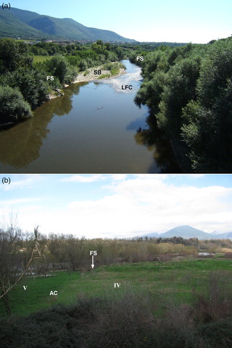
The five orders of river terraces are separated by remnants of FS. The field survey revealed that these scarps are generally strongly weathered and/or reshaped by erosional processes and agricultural practices. The less reshaped FS are those currently bordering the active channel ((a)), which are about 3–4 m high and affected by numerous small bank failures, generally of fall type. In contrast, the remnants of the older scarps are hardly higher than 1.5 m and often gently sloping, especially where shaped into poorly cemented or loose sandy or silty-sandy deposits ((b)).
Figure 3. (a) Sub-vertical FS, covered by arboreal riparian vegetation, that border the active channel of the Calore River. A gravelly side-bar (SB) and the low-flow channel (LFC) are also clearly visible; (b) boundary between remnants of river terraces of the IV order (to the right) and V order (to the left). The boundary is marked by a weathered and reshaped FS, approximately 1 m-high, and by an AC.
The alluvial plain also shows evidence of former active channels, now abandoned. In the field, they look like smooth linear concavities, several tens or even hundreds of metres long ((b)). On colour orthophotos, they often display darker colours than the surrounding land surfaces, probably due to a higher organic matter and/or water content of the topsoil (CitationMarchetti, 2000). The surface area of the ACs ranges from 0.001 to 0.2 km2. Morphometric analysis of the channels () shows that the Lower Calore River underwent a widening between 1870 and 1909, followed by a narrowing that lasted until 1998 (). Channel sinuosity experienced slight variations, consisting of a decrease in the first time period and an increase in the second period. The river also underwent a shortening, except for the period 1936–1955, when the length increased by ∼2 km.
Figure 4. Two-by-two geomorphological sketch maps of the Lower Calore River active channel between 1870 and 1998, showing variations in channel width, position and sinuosity.
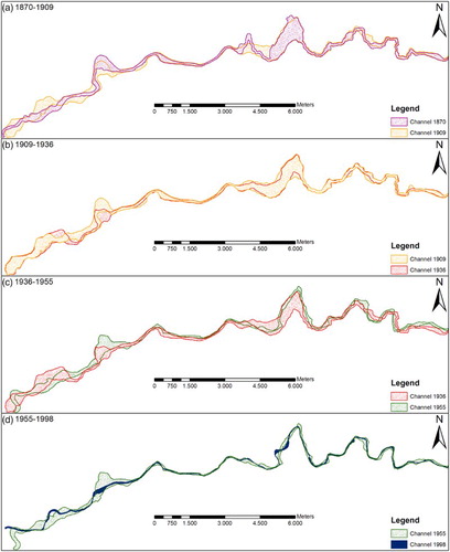
Table 2. Main morphological changes of the Lower Calore River between 1870 and 1998.
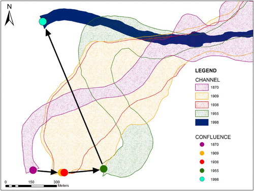
At the river confluence, the spatial distribution of the ACs highlighted several shifts of the confluence into the Volturno River (; ). A first shift occurred between 1870 and 1909, when the confluence migrated east-southeastward by 173 m. Between 1909 and 1936, notwithstanding slight adjustments of the active channel, the location of the confluence remained almost unchanged. Between 1936 and 1955, the confluence moved some 244 m east-northeast. Major shifting occurred between 1955 and 1998 (CitationMagliulo et al., 2013) and consisted of a north-northwestward migration of ∼934 m of the confluence point ( and ).
Figure 5. Geomorphological sketch map showing the migration of the Calore-Volturno confluence between 1870 and 1998. For the sake of readability, only the Calore River channel is shown (Volturno River excluded).
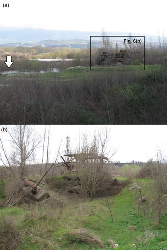
Among the anthropic landforms, two sediment extraction sites were surveyed. The first, located to the northwest of Solopaca, is now abandoned and submerged during flooding (). The second, in the easternmost sector of the study area, is currently active with likely extraction of sediments directly from the riverbed.
Figure 6. (a) Abandoned sediment extraction site to the northwest of Solopaca village. Note, to the left, the emergence of the groundwater table (white arrow). (b) Details of (a).
With regard to the age of the alluvial plain (see inset map in the Main Map), the outer sector had already formed before 1870. For the inner sector (i.e. located next to the current active channel), 40% of the current surface formed between 1909 and 1936, 28% between 1955 and 1998 and 20% between 1936 and 1955; lower percentages were formed in the other time-spans (i.e. <1870 and 1870–1909).
5. Conclusions
The integration of GIS analysis of topographic maps and aerial photos with field survey allowed production of a 1:18,000-scaled geomorphological map of the alluvial plain of the Lower Calore River (Southern Italy, Main Map). The map provides information about the evolutionary trend of the river over ∼130 years ( and ; ). In fact, the spatial distribution and pattern of the ACs in the alluvial plain shows shifts in channels and confluence positions ( and ); the five detected orders of river terraces highlight an overall incision of ∼7 m with intervening phases of deposition and/or lateral planation. Finally, analysis of the morphometric features of the channels highlight an overall but discontinuous narrowing, shortening and increase in sinuosity of the investigated river ().
The map could be a useful tool for many purposes, including assessing flood hazard and risk. This is of paramount importance in an area which has suffered from major floods, as on 15 October 2015. This flood damaged primarily infrastructure and agricultural production, which mainly affects the local economy. Geomorphological characterization of the alluvial plain and an understanding of river processes and the evolutionary trend are fundamental to support a correct land management aimed at reducing the destructive effects of floods.
Software
Esri ArcView 3.2 and ArcGIS 9.3 were used to georeference the maps, digitize landforms and create, update and query the database associated with the layers and, finally, to produce the map.
Geomorphology of the Lower Calore River alluvial plain (southern Italy).pdf
Download PDF (37.1 MB)Acknowledgments
Authors are grateful to Dr Tommaso Piacentini, Dr Aldino Bondesan and Dr Jennifer E. Carrell for the useful comments and suggestions which greatly improved the scientific rigour and readability of the submitted Map and manuscript. Thanks are due also to Dr Bastiaan Notebaert and Dr Mike Smith for the editing work.
Disclosure statement
No potential conflict of interest was reported by the authors.
ORCID
Paolo Magliulo http://orcid.org/0000-0002-8322-731X
Additional information
Funding
Related Research Data
References
- Bergomi, C., Manfredini, M., & Martelli, G. (1975). Note illustrative della Carta Geologica d’Italia alla scala 1:100.000, Foglio 173 (Benevento). Roma: Servizio Geologico d'Italia, 160 pp.
- Bondesan, A. (2015). Carta Geomorfologica della provincia di Treviso, scala 1:50.000. Florence: Provincia di Treviso-Università di Padova. 9788897784647
- Bondesan, A., Meneghel, M., Rosselli, R., & Vitturi, A. (2004). Geomorphological map of the province of Venice, scale 1:50,000. Florence: LAC, 4 sheets, 1 CD-Rom.
- Bonfante, A., Basile, A., Buonanno, M., Manna, P., & Terribile, F. (2005). Un esempio metodologico di utilizzo della modellistica idrologica e delle procedure GIS nella zonazione viticola. Bollettino della Società Italiana della Scienza del Suolo (SISS), 54, 1–2.
- De Graaff, L. W. S., De Jong, M. G. G., Rupke, J., & Verhofstad, J. (1987). A geomorphological mapping system at scale 1:10.000 for mountainous areas (Austria). Zeitschrift für Geomorphologie, 31, 229–242.
- De Vivo, B., Rolandi, G., Gans, P. B., Calvert, A., Bohrson, W. A., Spera, F. J., & Belkin, H. E. (2001). New constraints on the pyroclastic eruptive history of the Campanian volcanic Plain. Mineralogy and Petrology, 73, 47–65. doi:10.1007/s007100170010
- Furlanetto, P., & Bondesan, A. (2015). Geomorphological evolution of the plain between the Livenza and Piave Rivers in the sixteenth and seventeenth centuries inferred by historical maps analysis (Mainland of Venice, Northeastern Italy). Journal of Maps, 11(2), 261–266. doi:10.1080/17445647.2014.947341
- Gioia, D., Sabato, L., Spalluto, L., & Tropeano, M. (2011). Fluvial landforms in relation to the geological setting in the ‘Murge Basse’ karst of Apulia (Bari Metropolitan Area, southern Italy). Journal of Maps, 7, 148–155. doi: 10.4113/jom.2011.1136
- Gregory, K. J. (2006). The human role in changing river channels. Geomorphology, 79, 172–191. doi:10.1016/j.geomorph.2006.06.018
- Guerriero, L., Revellino, P., Coe, J. A., Focareta, M., Grelle, G., Albanese, V., … Guadagno, F. M. (2013). Multi-temporal maps of the Montaguto earth flow in southern Italy from 1954 to 2010. Journal of Maps, 9(1), 135–145. doi:10.1080/17445647.2013.765812
- Guida, D., De Pippo, T., Cestari, A., Siervo, V., & Valente, A. (2009). Applications of the hierarchic GIS-based geomorphological mapping system. In M. Marchetti, & M. Soldati (Eds.), The role of geomorphology in land management, abstract volume (pp. 109–110). 3rd AIGEO National Conference, Modena, September 13–18.
- Hooke, J. M. (2006). Human impacts on fluvial systems in the Mediterranean region. Geomorphology, 79, 311–335. doi:10.1016/j.geomorph.2006.06.036
- Knox, J. C. (1993). Large increases in flood magnitude in response to modest changes in climate. Nature, 361, 430–432. doi: 10.1038/361430a0
- Magliulo, P. (2005). Quaternary deposits and geomorphological evolution of the Telesina Valley (Southern Apennines). Geografia Fisica e Dinamica Quaternaria, 28, 125–146.
- Magliulo, P., Russo, F., & Valente, A. (2007). Tectonic significance of geomorphological features in the Telesina Valley (Campanian Apennines). Bollettino della Società Geologica Italiana (Italian Journal of Geosciences), 126, 397–409.
- Magliulo, P., Valente, A., & Cartojan, E. (2013). Recent geomorphological changes of the middle and lower Calore River (Campania, Southern Italy). Environmental Earth Sciences, 70, 2785–2805. doi:10.1007/s12665-013-2337-8
- Marchetti, M. (2000). Geomorfologia Fluviale. Bologna: Pitagora Editrice.
- Mostardini, F., & Merlini, S. (1986). Appennino centro meridionale. Sezioni geologiche e proposta di modello strutturale. Memorie Società Geologica Italiana, 35, 177–202.
- Napieralski, J., Barr, I., Kamp, U., & Kervyn, M. (2013). Remote sensing and GIS science in geomorphological mapping. In J. Shroder (Editor in Chief), & M. P. Bishop (Ed.), Treatise on geomorphology (pp. 187–227). SanDiego, CA: Academic Press. Vol. 3, Remote Sensing and GIScience in Geomorphology.
- O'Connor, J. E., Jones, M. A., & Haluska, T. L. (2002). Flood plain and channel dynamics of the Quinaultand Queets rivers, Washington, USA. Geomorphology, 51, 313–359. doi:10.1016/S0169-555X(02)00324-0
- Otto, J.-C., Geilhausen, M., & Gustavsson, M. (2011). Cartography: Design, symbolization and visualization of geomorphological maps. In M. J. Smith, P. Paron, & J. Griffiths (Eds.), Geomorphological mapping: A professional handbook of techniques and applications (pp. 253–295). London: Elsevier.
- Patacca, E., & Scandone, P. (2007). Geology of the Southern Apennines. Bollettino della Società Geologica Italiana, 7, 75–119.
- Piacentini, T., Urbano, T., Sciarra, M., Schipani, I., & Miccadei, E. (2015). Geomorphology of the floodplain at the confluence of the Aventino and Sangro rivers (Abruzzo, Central Italy). Journal of Maps. doi:10.1080/17445647.2015.1036139
- Rădoane, M., Obreja, F., Cristea, I., & Mihailă, D. (2013). Changes in the channel-bed level of the eastern Carpathian rivers: Climatic vs. human control over the last 50 years. Geomorphology, 193, 91–111. doi:10.1016/j.geomorph.2013.04.008
- Rinaldi, M., Surian, N., Comiti, F., & Bussettini, M. (2015). A methodological framework for hydromorphological assessment, analysis and monitoring (IDRAIM) aimed at promoting integrated river management. Geomorphology. doi:10.1016/j.geomorph.2015.05.010.
- Rosskopf, C. M., & Scorpio, V. (2013). Geomorphologic map of the Biferno River valley floor system (Molise, Southern Italy). Journal of Maps, 9(1), 106–114. doi:10.1080/17530350.2012.755385
- Seijmonsbergen, A. C. (2013). The modern geomorphological map. In J. Shroder (Editor in Chief), A. D. Switzer, & D. M. Kennedy (Eds.), Treatise on geomorphology (pp. 35–52). San Diego, CA: Academic Press. Vol. 14, Methods in Geomorphology.
- Smith, M. J., Paron, P., & Griffiths, J. S. (2011). Geomorphological mapping, methods and applications ( Developments in earth surface processes, 15). Oxford: Elsevier.
- Starkel, L. (2002). Change in the frequency of extreme events as the indicator of climatic change in the Holocene (in fluvial systems). Quaternary International, 91, 25–32. doi: 10.1016/S1040-6182(01)00099-4
- Surian, N., & Rinaldi, M. (2003). Morphological response to river engineering and management in alluvial channels in Italy. Geomorphology, 50, 307–326. doi:10.1016/S0169-555X(02)00219-2
- Surian, N., Rinaldi, M., Pellegrini, L., Audisio, C., Maraga, F., Teruggi, L., … Ziliani, L. (2009). Channel adjustments in northern and central Italy over the last 200 years. In L. A. James, S. L. Rathburn, & G. R. Whittecar (Eds.), Management and restoration of fluvial systems with broad historical changes and human impacts, geological society of America special paper 451 (pp. 83–95). Boulder: GSA Books Science. doi:10.1130/2009.2451(05).
- Valente, A., & Magliulo, P. (2012). A GIS-based geomorphological mapping of the Calore River alluvial plain in Benevento area (Campania, Italy). Rendiconti Online della Società Geologica Italiana, 21, 1161–1163.