
ABSTRACT
The 1:5000 scale Geological Map of the Fontane talc mineralization (FTM) aims to give new information about the origin and geological structure of an important talc mineralization occurring in the axial sector of the Italian Western Alps. The FTM is hosted within a pre-Carboniferous polymetamorphic complex which was deformed and metamorphosed during both Variscan and Alpine orogenesis, and is part of the Dora-Maira continental crust. Field mapping and underground investigations highlight that the talc bodies (i) never crop out but occur at depth along a well-defined lithostratigraphic association between micaschist, marble and gneiss and (ii) were deformed during different Alpine-related deformation phases (i.e. D1, D2 and D3 syn-metamorphic phases and post-metamorphic extensional faulting). The here defined lithostratigraphic and structural characterization of talc bodies, is an input for further research into the geodynamic context of where talc forms and for new mineral exploration outside the mapped area.
1. Introduction
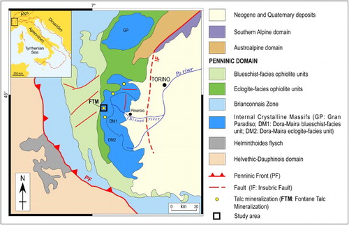
One of the industry-related geological features of the Italian Western Alps is a discontinuous, several kilometre-wide belt of talc mineralizations (throughout the paper we define talc mineralization as a geological body with a significant content of talc). The most important of these mineralizations (and one of the most important in Europe), due to both quantity and quality of the extracted talc, is located in the Germanasca Valley (Italian Western Alps) and is known as the Fontane talc mineralization (FTM hereafter) (CitationGrill, Pagliani, & Sacchi, 1955; CitationPeretti, 1966; CitationSandrone et al., 1990; CitationSandrone & Zucchetti, 1989; CitationSandrone, Trogolo Got, Respino, & Zucchetti, 1987; CitationZucchetti, 1969, Citation1972). The FTM is hosted within a pre-Carboniferous polymetamorphic complex that was deformed and metamorphosed during both Variscan and Alpine orogenesis, and is part of the Dora-Maira continental crust (CitationSandrone, Cadoppi, Sacchi, & Vialon, 1993) ().
Figure 1 . Localization of the FTM in the tectonic map of the Western Alps.
Talc exploitation started in the mid-1800s in the Germanasca Valley and gradually extended into adjacent valleys, until talc production reached over 40,000 tons per year (CitationRidoni, 1938). After the Second World War, talc production progressively decreased and the FTM is now the only site where talc is currently being extracted.
Despite its industrial significance, both the origin and geological structure of the FTM has never been defined in detail, and a published map exists only at small scale (i.e. the Pinerolo sheet of the Geological Map of Italy at 1:100,000 scale; CitationMattirolo, Novarese, Franchi, & Stella, 1913). In this paper, we present a new 1:5000 scale geological map that spans an area of about 8 km2 above the main infrastructure (i.e. tunnels) of both past and current extraction sites, with the aim of further advancing knowledge about geology of the FTM. Since the talc bodies never crop out, we have integrated the main map with geological cross sections that allow identification of their location at depth, as well as defining their geometry and lithostratigraphic association with embedding rocks.
2. Methods
The main map presented in this study is the result of fieldwork carried out at 1:5000 scale. Lithological observations and the collection of structural data were performed both in the field and at underground locations. Data were stored in a geographical information system (GIS) database (Coordinate System WGS 1984 UTM Zone 32N) and represented on a raster topographic map derived from ‘Carta Tecnica Provinciale’ 1:5000 (‘Dai tipi di proprietà della Città Metropolitana di Torino – Servizio Cartografico’, authorization n.105625/2015 on 21 July 2015).
The main map includes (i) three cross sections located in the area where talc is currently being extracted and defined through an integration of field data with borehole data (i.e. data available from companies holding the mining concession over the years) and (ii) a 1:20,000 scale tectonic map wherein geological interpolation, interpretation and generalization of outcrops and structures are given.
3. Regional setting
The FTM is located along the western edge of the Dora-Maira, a slab of paleo-European continental crust which belongs to the Penninic Domain of the Western Alps () (see e.g. CitationBigi et al., 1990; CitationDal Piaz, Bistacchi, & Massironi, 2003). The Dora-Maira (CitationCadoppi et al., 2002; CitationSandrone et al., 1993; CitationVialon, 1966) was involved in Alpine-related E-dipping subduction, W-verging continental collision and deep crust/mantle indentation (see e.g. CitationChopin, Henry, & Michard, 1991; CitationWheeler, 1991), and is now stacked in the axial sector of the Western Alps and tectonically overlain by blueschist-facies and eclogite-facies meta-ophiolite units (i.e. the Queyras Schistes Lustrès Complex and the Monviso Meta-ophiolite Complex, respectively; see e.g. CitationBalestro et al., 2014; CitationFesta, Balestro, Dilek, & Tartarotti, 2015; CitationTricart & Schwartz, 2006).
In its northern sector, the Dora-Maira comprises two main superposed units that, during Alpine orogeny, were metamorphosed under different P–T peak conditions (). The upper one corresponds to an eclogite-facies polymetamorphic complex, which consists of metasediments and Upper Ordovician meta-intrusives (CitationBussy & Cadoppi, 1996) covered by thin Mesozoic carbonate metasediments; the lower one consists of a blueschist-facies Permo-Carboniferous monometamorphic complex (i.e. the Pinerolo Graphitic Complex; CitationBorghi, Cadoppi, Porro, Sacchi, & Sandrone, 1984; CitationSandrone et al., 1993; CitationVialon, 1966). Both complexes contain meta-intrusives of granitic to dioritic composition, which can be related to a late Variscan magmatic event (CitationBussy & Cadoppi, 1996).
The FTM is included within the upper, polymetamorphic complex, which was affected by Variscan-related medium-grade metamorphism and, after the Alpine-related eclogite-facies metamorphism, was pervasively re-equilibrated under blueschist- and greenschist-facies metamorphic conditions (CitationBorghi & Sandrone, 1990; CitationCadoppi, 1990; CitationCadoppi & Tallone, 1992; CitationCamanni, 2010; CitationDamiano, 1997; CitationSandrone et al., 1987, Citation1990).
4. Lithostratigraphy
In the main map, the Dora-Maira consists of a Paleozoic basement and a thin Mesozoic cover.
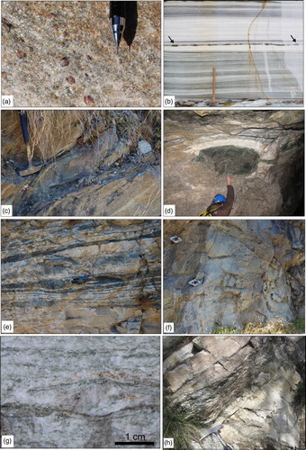
The Paleozoic basement corresponds to a pre-Carboniferous polymetamorphic complex that mainly consists of medium-grained garnet-chloritoid micaschist ((a)). This micaschist locally preserves Variscan-related medium-grade mineral relics, corresponding to garnet porphyroblasts ((a)) and muscovite lepidoblasts. The garnet-chloritoid micaschist embeds layers and bodies of impure marble, metabasite and gneisses. The impure marble is several metres-thick and is characterized by a mylonitic fabric defined by alternating centimetres-thick grey (calcite-rich) and yellow-whitish (dolomite-rich) layers ((b)). It also consists of subordinate chlorite, white mica, tremolite and clinopyroxene (diopside), which likely represents a relic of the Variscan mineral assemblage. The metabasite crops out both as boudinage layers (up to tens of meters-thick) and small boudins (decimetre in size), and occurs within the micaschist ((c)) and marble ((b) and 2(d)). The metabasite, despite its widespread re-equilibration under greenschist-facies conditions, preserves relics of the eclogitic assemblage consisting of garnet, omphacite, white mica (phengite) and rutile. The up to tens of meters-thick gneisses can be distinguished in fine-grained layered gneiss ((e)) and coarse-grained K-feldspar-bearing ones ((f) and 2(g)). The former is characterized by a compositional banding defined by alternating centimetres-thick light grey and dark green layers ((e)), which primarily consist of albite + quartz + garnet + phengite, and epidote + phengite + albite + quartz + Ca-amphibole, respectively. The coarse-grained K-feldspar-bearing ((f) and 2(g)) gneiss also consists of quartz, albite, phengite, epidote and biotite, and is characterized by occurrences of centimetres to decimetres-thick levels of silvery micaschist ((h)), which is made up of quartz and white mica (phengite).
Figure 2 . (a) Medium-grained garnet-chloritoid micaschist with porphyroblasts of centimetric pre-Alpine garnet (road to Rodoretto Village); (b) impure marble with mylonitic fabric defined by a compositional banding of grey (calcite-rich) and yellow-whitish (dolomite-rich) alternating layers. Black arrows indicate a boudinated centimetres-thick layer of metabasite occurring within the marble (Rocca Bianca quarry, just outside the study area); (c) and (d) boudins of metabasite embedded into the micaschist and marble, respectively (road to Rodoretto Village and Gianna mine tunnel); (e) layered gneiss with its characteristic compositional banding (near the bridge on the mouth of the Rodoretto Stream in the Germanasca Stream); (f) outcrop view and (g) detail of the K-feldspar-bearing gneiss (road to Rodoretto Village); (h) decimetres-thick level of silvery micaschist embedded in the K-feldspar-bearing gneiss (Serrevecchio locality).
The Mesozoic cover consists of massive white marbles and overlying calcschists. The former is made up of calcite, with minor dolomite and white mica (phengite), and is locally characterized by occurrences of several centimetres-thick metapelitic layers. The calcschists are fine- to medium-grained and consist of calcite, quartz, white mica (phengite), with minor chlorite and albite. Similar cover successions occur in other sectors along the western edge of the Dora-Maira and have been interpreted as Middle Triassic to Early Jurassic in age (CitationBalestro, Festa, & Tartarotti, 2015; CitationBalestro, Fioraso, & Lombardo, 2011, Citation2013).
5. Structures
Variscan-related structures have been recognized exclusively as microscale relics, whereas Alpine structures are widely exposed at the mesoscale and result from three main syn-metamorphic deformation phases (named D1, D2 and D3).
The D1 developed during the eclogite-facies metamorphism and is responsible for the development of a mylonitic foliation (i.e. the S1; (a)). Symmetric and asymmetric boudins of metabasite occurring within the impure marble, garnet-chloritoid micaschist and layered gneisses, are interpreted to be related to the S1-parallel stretching during D1 simple shear. The D1-related stretching lineation dips at a low angle to the W (CitationBorghi & Sandrone, 1990).
Figure 3 . D2 and D3 structures. (a) S1 mylonitic layering of impure marble fabric deformed by D2 folds (Maiera quarry, near the study area); (b) isoclinal D2 folds with thickened hinges occurring within the garnet-chloritoid micaschist (road to Rodoretto Village); (c) D3 structures folding of S2 foliation within the garnet-chloritoid micaschists (road to Rodoretto Village); (d) Type-3 interference pattern (CitationRamsay, 1967) between D2 and D3 folds and related axial plane foliation (S2) and axial plane (AP3), occurring within the impure marble (ma) and garnet-chloritoid micaschist (ms) (sample from the Gianna mine tunnel).
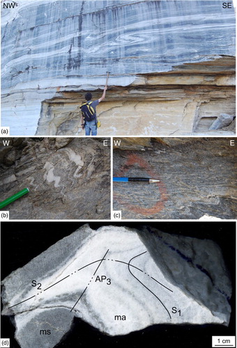
The D2 developed under the early blueschist-facies metamorphic re-equilibration and is defined by isoclinal folds, with thickened hinges and thinned limbs ((a) and 3(b)), characterized by N–S sub-horizontal axes and W-dipping axial planes (). The pre-existing S1 mylonitic fabric is clearly deformed by D2 folds that developed an axial plane foliation (i.e. the S2), which corresponds to the W-dipping main regional foliation (). At the map scale, an example of these structures is the folding of the impure marble body in the central part of the main map (see also cross section (e)–(f)).
Figure 4 . Contoured stereographic projections (equal-area, lower hemisphere) of the D2 and D3 structures. The great circles show the mean orientation. n is the number of data.
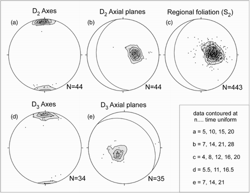
D2 isoclinal folds and their axial plane foliation appear to be gently refolded by D3 folds ((c) and 3(d)), especially in the western part of the main map. D3 folds developed under greenschist-facies metamorphic conditions and are characterized both by tight profiles in the form of crenulation folds ((c)) and open to gentle geometries. D3 axial planes weakly dip towards the NE and D3 axes are on average sub-horizontal with a roughly N–S trend ().
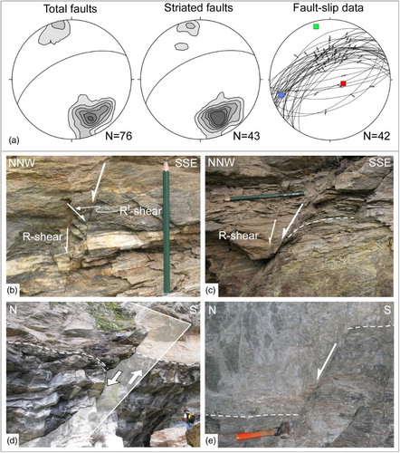
A last significant phase of deformation is a stage of extensional faulting that post-dates the syn-metamorphic structures and has been also described outside the study area (CitationPerrone, Cadoppi, Tallone, & Balestro, 2011; CitationPerrone, Morelli, Cadoppi, Tallone, & Giardino, 2009). Extensional faults are nearly NE–SW striking and NW steeply dipping ((a)), and their displacements range from a minimum of a few centimetres to a maximum of several metres ((b)–(e)). Fault rocks are mostly represented by tectonic breccia that are well exposed close to the Fontane locality and in the northern part of the main map (i.e. the ‘Meison breccias’ of CitationNovarese, 1895, CitationBorghi et al., 1984). At map scale, extensional faults are expressed as NE–SW hectometre- to kilometre-scale fault segments arranged in en-echelon, left-stepping geometrical pattern, and with spacings of several hundreds of metres.
Figure 5 . (a) Contoured stereographic projections (equal-area, lower hemisphere projections) of the extensional faults. The great circles show the mean fault plane orientations. Data contoured at n = 2, 4, 6, 8, 10, 12 times uniform, n is the number of data. The red, blue and green squares represent the maximum (P), intermediate and minimum (T) shortening axes for the average incremental strain solution, respectively; (b) and (c) Riedel shear-sense indicators (R and R′) and inflection of the S2 foliation (dashed white line) along normal fault planes occurring within the garnet-chloritoid micaschist (entrance of the Gianna mine tunnel); (d) Plurimetric displacement of the contact (dashed white line) between the garnet-chloritoid micaschist (above) and impure marbles (below) (E of Fontane Village); (e) pluridecimetric displacement of the contact (dashed white line) between the K-feldspar-bearing gneiss (above) and garnet-chloritoid micaschist (below) (Gianna mine tunnel).
6. Geometry of the FTM
Defining the structure and extent of the FTM is of critical importance both for understanding the origin of the talc and for any industrial operations related to its extraction. Talc is not distributed in continuous horizons but forms isolated bodies embedded within the garnet-chloritoid micaschist and the K-feldspar-bearing gneiss closely associated with the impure marble.
Talc bodies appear to define lenses with a shape similar to that of the boudins of metabasite (see cross section (c)–(d)), suggesting that their early geometry resulted from D1 deformation. These lenses were later deformed during the D2 phase and now outcrop in the form of thickened hinges of rootless folds, and were slightly affected by the D3 that seems to cause minor changes in the dip of the isolated lenses.
Finally, extensional faults that intersect talc bodies at depth appear to be responsible for their dislocations towards the NW with displacements of up to several tens of metres (see cross section (a)–(b)).
7. Conclusions
The 1:5000 scale geological map of the FTM gives new information for interpreting the origin and distribution of talc bodies.
Detailed geological mapping and underground observations highlight that the talc bodies (i) are embedded within a pre-Carboniferous polymetamorphic complex, (ii) occur along a well-defined lithostratigraphic association between micaschist, marble and gneiss and (iii) never occur within the Mesozoic cover.
Structural analysis highlights that the talc bodies were clearly deformed during Alpine-related deformation phases (i.e. the D1, D2 and D3 phases) and, therefore, their genesis predate Alpine tectonics.
These considerations may be useful for future research regarding the origin of the FTM as well as other talc mineralizations occurring along the western edge of the Dora-Maira. Pre-rift tectonics (and associated metasomatic processes?) which affected the paleo-European continental margin likely appear as a geodynamic context wherein talc could be formed. An extensional tectonics model is described for other important talc mineralization, such as the Trimouns Talc Deposit in the Pyrenees (CitationSchärer, de Parseval, Polvé, & de Saint Blanquat, 1999).
Moreover, the here defined lithostratigraphic and structural characterization of the FTM may represent a useful geological model for new mineral explorations outside the map area.
Software
The geological map was digitized using Esri ArcGIS v 9.3.
Geology of the Fontane Talc Mineralization (Germanasca Valley, Italian Western Alps).pdf
Download PDF (32.3 MB)Acknowledgements
We thank E. Casciello, P. Conti and B. Cattoor for their constructive reviews, and R. Orndorff for his editorial handling. G. Codegone and E. Cerino Abdin are acknowledged for their help during fieldwork. Thanks to S. Bonatto, P.A. Donguy and F. Monticelli (Imerys Talc company) for making available information about mining activities.
Disclosure statement
No potential conflict of interest was reported by the authors.
References
- Balestro, G., Festa, A., & Tartarotti, P. (2015). Tectonic significance of different block-in-matrix structures in exhumed convergent plate margins: Examples from oceanic and continental HP rocks in Inner Western Alps (northwest Italy). International Geology Review, 57(5–8), 581–605. doi:10.1080/00206814.2014.943307
- Balestro, G., Fioraso, G., & Lombardo, B. (2011). Geological map of the upper Pellice Valley (Italian Western Alps). Journal of Maps, 7, 634–654. doi:10.4113/jom.2011.1213
- Balestro, G., Fioraso, G., & Lombardo, B. (2013). Geological map of the Monviso massif (Western Alps). Journal of Maps, 9, 623–634. doi:10.1080/17445647.2013.842507
- Balestro, G., Lombardo, B., Vaggelli, G., Borghi, A., Festa, A., & Gattiglio, M. (2014). Tectonostratigraphy of the northern Monviso Meta-ophiolite Complex (Western Alps). Italian Journal of Geosciences, 133(3), 409–426. doi:10.3301/IJG.2014.13
- Bigi, G., Castellarin, A., Coli, M., Dal Piaz, G. V., Sartori, R., Scandone, P., & Vai, G. B. (1990). Structural model of Italy, sheet 1, C.N.R. Firenze: Progetto Finalizzato Geodinamica, Litografia SELCA.
- Borghi, A., Cadoppi, P., Porro, A., Sacchi, R., & Sandrone, R. (1984). Osservazioni geologiche nella Val Germanasca e nella media Val Chisone (Alpi Cozie). Bollettino del Museo Regionale di Scienze Naturali di Torino, 2, 503–530.
- Borghi, A., & Sandrone, R. (1990). Structural and metamorphic constraints to the evolution of a NW sector of the Dora-Maira massif (Western Alps). Memorie della Società Geologica Italiana, 45, 131–141.
- Bussy, F., & Cadoppi, P. (1996). U-Pb zircon dating of granitoids from the Dora-Maira massif (Western Italian Alps). Schweizerische Mineralogische und Petrographische Mitteilungen, 76, 217–233.
- Cadoppi, P. (1990). Geologia del basamento cristallino nel settore settentrionale del Massiccio Dora-Maira (Alpi Occidentali) (Ph.D thesis). University of Turin, Turin, Italy, p. 208.
- Cadoppi, P., Castelletto, M., Sacchi, R., Baggio, P., Carraro, F., & Giraud, V. (2002). Note illustrative della Carta Geologica d'Italia alla scala 1:50.000 – Foglio 154, Susa. Roma: Servizio Geologico d'Italia, p. 127.
- Cadoppi, P., & Tallone, S. (1992). Structural and lithostratigraphic heterogeneity of the northern part of Dora-Maira massif (Western Alps). Atti Ticinesi di Scienze della Terra, 35, 9–18.
- Camanni (2010). Geological-structural analysis and 3D modelling of the Fontane talc mineralization (Germanasca valley, inner cottian alps) (Unpublished MSc thesis). Univ Turin, Italy, p. 126.
- Chopin, C., Henry, C., & Michard, A. (1991). Geology and petrology of the coesite-bearing terrain, Dora Maira massif, Western Alps. European Journal of Mineralogy, 3, 263–292. doi: 10.1127/ejm/3/2/0263
- Dal Piaz, G. V., Bistacchi, A., & Massironi, M. (2003). Geological outline of the Alps. Episodes, 26, 175–180.
- Damiano, A. (1997). Studio geologico delle mineralizzazioni a talco nelle valli Germanasca, Chisone e Pellice (Massiccio Dora-Maira, Alpi Cozie) (Unpublished MSc thesis). Univ Turin, Italy, p. 145.
- Festa, A., Balestro, G., Dilek, Y., & Tartarotti, P. (2015). A Jurassic oceanic core complex in the high-pressure Monviso ophiolite (western Alps, NW Italy). Lithosphere, 7(6), 646–652. doi:10.1130/L458.1
- Grill, E., Pagliani, G., & Sacchi, L. (1955). La genesi del talco della valle della Germanasca (Alpi Cozie). Istituto Lombardo di Scienze e Lettere, 88, 442–490.
- Mattirolo, E., Novarese, V., Franchi, S., & Stella, A. (1913). Carta Geologica d'Italia a scala 1:100.000, foglio 67 Pinerolo. Roma: Litografia Artistica Cartografica.
- Novarese, V. (1895). Sul rilevamento geologico eseguito nel 1894 in valle della Germanasca (Alpi Cozie). Bollettino del Reale Comitato Geologico Italiano, 26, 253–282.
- Peretti, L. (1966). Geologia e genesi dei giacimenti di talco nel Pinerolese. Bollettino Associazione Mineraria Subalpina, 3, 283–306.
- Perrone, G., Cadoppi, P., Tallone, S., & Balestro, G. (2011). Post-collisional tectonics in the Northern Cottian Alps (Italian Western Alps). International Journal of Earth Sciences, 100, 1349–1373. doi:10.1007/s00531-010-0534-1
- Perrone, G., Morelli, M., Cadoppi, P., Tallone, S., & Giardino, M. (2009). A multidisciplinary approach to the study of the fault network in the internal Cottian Alps (Western Alps). Italian Journal of Geosciences, 128, 541–549.
- Ramsay, J. G. (1967). Folding and fracturing of rocks. New York, NY: McGraw-Hill Book Company, p. 560.
- Ridoni, E. (1938). Il talco e la grafite delle Alpi Cozie. L'industria Mineraria d'Italia e d'Oltremare, 16(4–6), 1–23.
- Sandrone, R., Borghi, A., Carosso, G., Morsetti, C., Tagliano, C., & Zucchetti, S. (1990). Geometry of the talc deposit of Fontane, and structural evolution of the area (Dora Maira Massif, Western Alps). Bollettino Associazione Mineraria Subalpina, 27, 45–62.
- Sandrone, R., Cadoppi, P., Sacchi, R., & Vialon, P. (1993). The Dora-Maira massif. In J. F. von Raumer, & F. Neubauer (Eds.), Pre-Mesozoic Geology in the Alps (pp. 317–325). Berlin: Springer-Verlag.
- Sandrone, R., Trogolo Got, D., Respino, D., & Zucchetti, S. (1987). Osservazioni geo-giacimentologiche sulla miniera di talco di Fontane (Val Germanasca, Alpi Cozie). Memorie Scienze Geologiche Padova, 39, 175–186.
- Sandrone, R., & Zucchetti, S. (1989). Geology of the Italian high-quality cosmetic talc from the Pinerolo district (Western Alps). Proceedings of Symposium “Zuffardi’ days”, Cagliari, 1988.
- Schärer, U., de Parseval, Ph., Polvé, M., & de Saint Blanquat, M. (1999). Formation of the Trimouns talc-chlorite deposit (Pyrenees) from persistent hydrothermal activity between 112 and 97 Ma. Terra Nova, 11, 30–37. doi: 10.1046/j.1365-3121.1999.00224.x
- Tricart, P., & Schwartz, S. (2006). A north-south section across the Queyras Schistes lustrés (Piedmont zone, western Alps): Syn-collision refolding of a subduction wedge. Eclogae Geologicae Helvetiae, 99, 429–442. doi: 10.1007/s00015-006-1197-6
- Vialon, P. (1966). Etude géologique du Massif Cristallin Dora-Maira (Alpes Cottiennes internes-Italie). Trav. Lab. Géol. Grenoble, 4, p. 293.
- Wheeler, J. (1991). Structural evolution of a subducted continental sliver: The northern Dora Maira massif, Italian Alps. Journal of the Geological Society, 148, 1101–1113. doi: 10.1144/gsjgs.148.6.1101
- Zucchetti, S. (1969). Osservazioni sui giacimenti di talco della Val Germanasca (Torino) – Nota Preliminare. Bollettino Associazione Mineraria Subalpina, 6, 240–248.
- Zucchetti, S. (1972). Caratteri lito-mineralogici e genetici dei giacimenti di talco della Val Germanasca nelle Alpi Occidentali. Proceedings of the second international symposium on the Mineral Deposits of the Alps (pp. 263–279). Ljubljana, S. Kolenko. (Italia).