
ABSTRACT
We present a photo-geological map for the 185 km2 fault-bounded, Montefalco Basin, Umbria, Central Italy. The basin formed in the Quaternary in response to extensional tectonics dissecting folds and thrusts of the northern Apennines range. To prepare the 1:25,000 geological map, we integrated geological and morphological information obtained through the visual analysis of three sets of aerial photographs of different age, the collection of new field data, and the review of pre-existing surface and sub-surface geological data. We show that systematic interpretation of aerial photographs contributed to improving the geological mapping, providing information not readily available through traditional field mapping. We expect that the new map will be used for different types of geological and geomorphological investigations, including studies of active tectonic, Quaternary morpho-tectonics, sedimentological and stratigraphic analyses, mining and exploration investigations, and the analysis of landslide types, patterns and distribution.
1. Introduction
We present a photo-geological map for the Montefalco Quaternary Basin, Umbria, Central Italy. To prepare the map, we combined the visual interpretation of multiple sets of aerial photographs, with geological and geomorphological field surveys, and a critical review of pre-existing geomorphological (CitationCardinali, Antonini, Reichenbach, & Guzzetti, 2001; CitationGregori, 1988), surface (CitationRegione Umbria, 2014; CitationServizio Geologico d’Italia, 1969), and sub-surface (CitationGe.Mi.Na., 1962) geological information. The approach is commonly used for the production of geomorphological (CitationBucci, Cardinali, & Guzzetti, 2013; CitationBucci, Santangelo, Cardinali, Fiorucci, & Guzzetti, 2016; CitationCardinali et al., 2001; CitationSantangelo, Gioia, Cardinali, Guzzetti, & Schiattarella, 2014) and multi-temporal (CitationGalli, Ardizzone, Cardinali, Guzzetti, & Reichenbach, 2008; CitationGuzzetti, Galli, Reichenbach, Ardizzone, & Cardinali, 2006) landslide inventory maps, and it is more rarely adopted for mapping geological structures and for the production of basin-scale geological and structural maps (CitationBucci et al., 2016; CitationCardinali et al., 2001; CitationCiampalini, Garfagnoli, Antonielli, Del Ventisette, & Moretti, 2012; CitationHenderson & Saintot, 2011; CitationPucci et al., 2014; CitationSvennevig & Guarnieri, 2012). We adopted the approach to map the geology of an area characterized by gentle terrain, where intensive and widespread agriculture limits the number and size of the outcrops, most of which are small (a few square metres) and located along roads (road cuts) or river cuts.
2. Study area
The study area extends for 185 km2 in central Umbria, Italy, and encompasses the fault-bounded, intramontane Montefalco Basin (Main Map, A) that formed during the Quaternary, in response to extensional tectonics dissecting the pre-existing fold-and-thrust belt of the Northern Apennines range. In the area continental sediments crop out, Quaternary in age, that overlay pre-Quaternary marine sediments pertaining to the Umbria–Marche stratigraphic sequence (Cretaceous to Oligocene in age, CitationCresta, Monechi, & Parisi, 1989) and the Marnoso Arenacea Formation (early to middle Miocene in age, CitationRicci Lucchi & Pialli, 1973). The continental sediments of the Montefalco Basin form a basin filling sequence that consists of, from bottom (older) to top (younger), fine-grained (clay, silt, and find sand) lake and fluvial sediments, early Pleistocene in age (Bevagna Unit, BU), overlaid by coarse-grained (gravel and sand) alluvial fan sediments, early Pleistocene in age (Montefalco Unit, MU and Colle del Marchese Unit, CU), covered by younger palustrine (Pianacce Unit, PU), middle-to-late Pleistocene in age, and by alluvial and fluvial deposits (AD), late Pleistocene to Holocene in age (Main Map, 2). Since the upper Pliocene – early Pleistocene (CitationBarchi, Brozzetti, & Lavecchia, 1991, CitationBarchi, 2010), the area was affected by extensional tectonics. Hanging-wall subsidence induced by active normal faults is in competition with regional uplift of 0.5 mm/year, and produces subsiding basins incised by modern rivers (CitationPucci et al., 2014). After the end of the deposition, the continental basin experienced widespread erosion that formed the current landscape, characterized by rounded, asymmetrical, low elevation hills, separated by plains.
Elevation in the area ranges from 198 to 783 m (average = 361, mode = 320, median = 334), with terrain slope between 0° and 64° (average = 9, mode = 6, median = 7). The Puglia River flows to the W and drains the western part of the area into the Tiber River valley. The Attone River flows to the N and drains the central part of the area into the Valle Umbra plain. The eastern part of the area is also drained in the Valle Umbra by a network of minor, immature drainages, mainly flowing to the NE, roughly perpendicular to the southwestern margin of the Valle Umbria plain.
3. Methods
To prepare the 1:25,000 geological map of the Montefalco Quaternary Basin (Main Map), we extracted geological and morphological information through the integration of the visual analysis of three sets of aerial photographs, a new field survey, and a review of pre-existing geomorphological landslide inventory maps (CitationCardinali et al., 2001), and surface (CitationRegione Umbria, 2014; CitationServizio Geologico d’Italia, 1969) and sub-surface (CitationGe.Mi.Na., 1962) geological data.
Through the visual interpretation of the aerial photographs, we obtained photo-lithological and morpho-structural information related to the intersection between different lithological units and topography. This involved the interpretation of three sets of stereoscopic pairs of aerial photographs, including panchromatic (black and white) images taken in 1955 at 1:33,000 and in 1999 at 1:20,000 nominal scales, and colour images taken in 1977 at 1:13,000 nominal scale. The three sets of aerial photographs were studied jointly by two photo-interpreters who used a Galileo SFG 3/B ‘discussion’ stereoscope, with 1.25× and 4× zoom capability, to obtain a preliminary interpretation of the study area, which was then validated by a third interpreter who used a Galileo Siscam Falcon ZII ‘discussion’ stereoscope with a 1.5× to 13.5× continuous zoom. The ‘discussion’ stereoscope allows the simultaneous view of the same stereo-pair by two interpreters, reducing the subjectivity of the interpretation. Adopting a consolidated approach (CitationSantangelo, Marchesini, Bucci, et al., 2015), the photo-lithological and the morpho-structural information was first drawn on transparent plastic sheets placed over the aerial photographs. Next, the information was transferred visually onto a 1:10,000 scale digital topographic base map in a geographical information system (GIS). Visual transfer of the information to the digital base map was aided by recent (2015) high-resolution satellite images available from the Bing© mapping service.
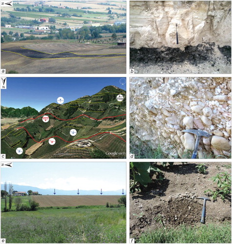
Where layered sediments crop out, single layers or groups of layers intersecting the topography leave distinct visual signatures, that is, ‘bedding traces’ (BT) (CitationSantangelo, Marchesini, Bucci, et al., 2015) visible on the aerial photographs, and in the field. In our study area, distinct BTs were identified where lignite layers crop out interbedded within sand, silt and clay layers. The identification of the BTs was facilitated by the colour contrast between the dark (black) lignite layers and the light (light grey, light brown, and ochre) sand, silt and clay layers ((a) and 1(b)). Other BTs, formed by differential erosion of more and less resistant sediments, were mapped where sand layers or conglomerate banks crop out ((c) and 1(d)).
Figure 1. Landscape view (left column) and outcrop view (right column) of the Bevagna Unit (BU, a, b), of the Montafalco Unit (MU, c, d) and of the Pianacce Unit (PU, e, f). Images (a) and (b) show the striking difference in colours in both the landscape and in the outcrop of the lignite beds contained in the Bevagna Unit, BU. Image (c) shows the significant topographic relief generated by the Montefalco Unit, MU. Yellow dotted lines indicate some of the morphologic discontinuities interpreted as bedding indicators due to the alternation of gravelly, sandy and subordinated silty deposits, mainly dipping toward S–SW (NE), in the upper (lower) part of the relief. The relief is affected by two NW–SE trending normal faults, which separate three distinct domains, characterized by different bedding attitude. Blue symbols indicate bedding attitude obtained by aerial photo-interpretation (CitationMarchesini, Santangelo, Fiorucci, Cardinali, Rossi, & Guzzetti, 2013; CitationMarchesini, Santangelo, Guzzetti, Cardinali & Bucci, 2015; CitationSantangelo, Marchesini, Cardinali, et al., 2015b). Black (red) symbol is for field measurement, dip direction and inclination, of bedding (fault) planes. (d) The imbricates within the conglomerates are evident, the hammer tip indicates the flow direction (from NE to SW). Images (e) and (f) show the flat morphology (indicated by the blue arrows) and the dark brown lithology of the Pianacce unit, PU.
In the field, BTs were mapped using a hand-held laser telemeter with a global positioning system receiver, which provided the coordinate of target points located along the BTs. We used this information to validate the BT obtained from the aerial photographs, and to reduce the mapping errors due to the visual transfer of the information to the base map (CitationSantangelo, Marchesini, Cardinali, et al., 2015). The mapped BTs were used to estimate the attitude of the beddings. On the final map, bedding attitudes are shown in four classes, that is, (i) horizontal bedding [0°–1°), (ii) gently dipping bedding [1°–5°), (iii) moderately dipping bedding [5°–15°), and (iv) dipping bedding [>15°). We exploited this geometric information in the construction of the geological cross sections (Main Map).
Different types of layered sediments exhibit distinct visual and morphometric signatures. To provide a measure of the signature, we performed a morphometric analysis of the terrain elevation ((a)) and slope angle ((b)) for each lithological unit (Main Map, 2) using standard GIS techniques (http://www.qgis.org/). For the morphometric analysis we used the 10 m × 10 m TINITALY/01 Digital Elevation Model (CitationTarquini et al., 2007, Citation 2012), that was also used to produce the contours shown on the Main Map.
Figure 2. Box plots show the distribution of terrain elevation (a) and terrain slope (b) in each photo-geological unit. Legend: Umbria–Marche stratigraphic sequence (UM), Marnoso Arenacea Formation (MA), Bevagna Unit (BU), Montefalco Unit (MU), Colle del Marchese Unit (CU), Calcareous Tufa (CT), Pianacce Unit (PU), Fabbri member (FM), Alluvial, fluvial and fan deposit (AD+AF). Rectangles show 25th (low) and the 75th (high) percentiles, solid lines show 50th percentile, whiskers show 0th (low) and 100th (high) percentiles. Box width is proportional to area of unit.
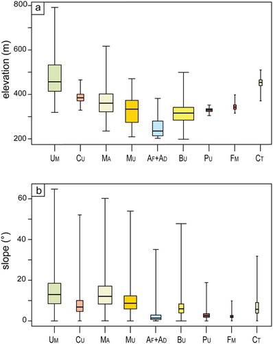
Recognition () and measurement () of the morphometric signatures facilitated the lithological and structural mapping (CitationBucci et al., 2016; CitationCardinali et al., 2001; CitationSantangelo, Marchesini, Bucci, et al., 2015). Where coarse-grained sediments are rhythmically interbedded with fine sediments (Montefalco Unit, MU; Colle del Marchese Unit, CU; Main Map, 2), selective erosion of the fine sediments (fine sand, silt, and clay) exposed the coarse sediments (coarse sand and gravel) producing a typical staircase morphology resulting from the alternation of steeper and gentler slopes formed by morpho-selection processes ((c)). In these sediments, terrain has elevation in the range 275–410 m (25th and 75th percentiles, (a)), and slope in the range 6°–13° (25th and 75th percentiles, (b)).
Where fine-grained sediments predominate (Bevagna Unit, BU), they form rhythmic repetitions of thin and very thin, planar or sub-planar layers or banks of clay, silt and fine sand, with locally interbedded lignite layers. Here, erosion acts evenly and shapes a gentler and more rounded topography, with less evident morphometric (elevation and slope) variations ((a)) due to local, minor lithological differences, or landslides. In these areas, elevation ranges between 290 and 340 m ((a)), and terrain slope between 4° and 8° ((b)).
Where palustrine (Pianacce Unit, PU) and fluvial-to-palustrine (Fabbri member, FM) sediments crop out, they form a smooth topography with elevation in the range 320–335 m ((a)) and terrain slope between 2° and 4° ((b)), with local minor variations at the outer edges of erosion surfaces ((e)). Lastly, alluvial deposits (AD), in the valley bottoms at elevations between 225 and 280 m ((a)), are characterized by a flat, level morphology with terrain slopes less than 3° ((b)).
The different visual appearance of the sediments cropping out in the study area was important for their recognition and mapping through the interpretation of the aerial photographs. The panchromatic photographs were used to identify and map lithological discontinuities and BTs in all the sediments, exploiting the difference in the grey tones resulting from different water content in the sediments, with clay and silt that appeared lighter (less moist) than the darker (more moist) sand.
The colour photographs were particularly useful to detect the lignite layers, which appear black (dark) in the photographs ((a) and 1(b)), and to map their associated BTs. We mapped five lignite layers – L2, L3, L4, L5, and L6, from oldest (lowest) to youngest (highest) – at different heights in the Bevagna Unit, characterizing the stratigraphic sequence of the W part of the basin. We constrained the stratigraphic position and thickness of the lignite layers using point data (i.e. boreholes W119, W128, and W150 on Main Map) obtained from the stratigraphy of past mining exploration wells in the Bastardo area (CitationGe.Mi.Na., 1962), which showed five distinct 1–3-m thick lignite layers in the central part of the Bevagna stratigraphic sequence (L2–L6), and one 5–10 m thick lignite layer at the base of the sequence (L1). We integrated the Ge.Mi.Na. borehole data with the stratigraphy obtained at the intersection points of the Ge.Mi.Na cross sections (G1, G2, and G3, Main Map), which were used to extrapolate at depth the base of the basin, and to constrain the overall thickness of the continental sequence.
Interpretation of the aerial photographs allowed recognition and mapping of geomorphological and tectonic features, including landslides, ancient, and relict alluvial fans, recent and active alluvial fans, recent floodplain deposits, and the outer edges of erosional surfaces (CitationCencetti & Conversini, 2003). The tectonic features are mainly Quaternary faults, which have the surface expression of tectonic lineaments, identified locally due to the alignment of triangular facets (not shown on the Main Map).
We used the field data to validate and integrate the lithological, bedding, tectonics, and geomorphological information obtained from the visual interpretation of the aerial photographs. We mapped field data at 1:10,000 scale on the same topographic base map used to map the photo-geological information. We used Google Earth© for the location and immediate visualization of the information. The field data were then stored for subsequent management and analysis in QGIS®. In the field, we surveyed 132 outcrops obtaining 172 structural (i.e. bedding and fault attitude, kinematic indicators on fault plains) and sedimentological (i.e. pebble imbrications) measurements (Main Map, inset C), whose analysis is beyond the scope of the map, and of the paper.
4. Photo-geological map
The photo-geological map of the Montefalco Quaternary Basin (Main Map) shows at 1:25,000 scale: (a) the pre-Quaternary carbonate and silicoclastic bedrock, (b) the continental sediments of the Montefalco Quaternary Basin (CitationBizzarri et al., 2011), (c) the location of single or groups of BT identified in the continental deposits, due to lignite, sand, and gravel horizons, (d) faults, including normal faults, transtentional faults, and faults whose kinematics remain unclassified, (e) bedding and fault attitude measurements, and (f) pebble imbrication measurements. The map also shows (g) geomorphological features, including shallow and deep-seated landslides, and the outer edges of erosional surfaces. Data obtained in the field and through photo-interpretation are shown separately on the map, using different colours. In addition, the map shows (h) the traces of five geological cross sections, (i) the traces of old geological cross sections from CitationGe.Mi.Na. (1962), and (j) the location of the exploration wells used to prepare the map and the cross sections, also from CitationGe.Mi.Na. (1962).
The map has three insets (Main Map, A, B, C). Inset A, in the upper-right corner of the Main Map shows the geographical location and the regional geological setting of the study area, with five main lithological complexes. Inset B, in the lower left corner of the Main Map, shows two anaglyphs that exemplify the visual signature of photo-lithological and morpho-structural settings in the study area. The anaglyphs were obtained from stereoscopic aerial photographs taken in 1954 at 1:33,000 scale, and in 1977 at 1:15,000 scale, using cyan (left) and magenta (right) colours. Inset C, in the lower-right corner of the Main Map, portrays a map showing the location of the 132 outcrops used as validation points. Two charts summarize statistics of terrain elevation and slope for the eight photo-geological units and members (1), a diagram exemplifying the stratigraphic relationships among the continental sediments in the Montefalco Basin (2), and five geological cross sections and six stratigraphic columns obtained from exploration wells (CitationGe.Mi.Na., 1962) and geological cross sections (3) complete the Main Map.
4.1. Lithological units
We subdivided the bedrock underlying the Pleistocene continental deposits into two litho-structural units (Main Map, A), based on their tectono-stratigraphic relationships, that is, (i) carbonate rocks (limestone, marly limestone, marl) pertaining to the Cretaceous–Miocene Umbria–Marche stratigraphic sequence, UM (CitationCresta et al., 1989) and (ii) silicoclastic rocks (sandstone, marl) pertaining to the Miocene Marnoso Arenacea Formation, MA (CitationRicci Lucchi & Pialli, 1973). The two units have distinctive morphometric signatures () and were mapped separately based on information shown on pre-existing geological maps (CitationRegione Umbria, 2014).
In the continental deposits of the Montefalco Basin, we recognized five photo-lithological units and one member (Main Map), which we have tentatively correlated to the litho-stratigraphic units defined in the literature (CitationRegione Umbria, 2014). From the oldest (lowest) to the youngest (highest), the lithological units comprise: (i) the Bevagna Unit (BU), (ii) the Montefalco Unit (MU), (iii) the Colle del Marchese Unit (CU), (iv) Calcareous Tufa (CT), (v) the Pianacce Unit (PU), and (vi) the Fabbri member (FM), which was not recognized before.
The Bevagna Unit (BU), early Pleistocene in age (CitationRegione Umbria, 2014), represents the lowest (and oldest) portion of the continental Montefalco Basin sequence, and it crops out extensively in the central part of the study area. The unit consists of fine-grained river and lacustrine sediments represented by grey clay, yellow clay, and sandy clay with minor gravels and cobbles. Lignite layers are present in the unit ((a) and 1(b)) (CitationRegione Umbria, 2014). In this unit, bedding attitude is generally horizontal, or slightly inclined, with low gradient monoclines that result in asymmetric relief. The 450 m thick, rhythmic alternation of clay and sandy clay represents a mechanical and hydrogeological anisotropy in the sedimentary sequence that controls the distribution of landslides, which are abundant in the unit, and particularly along dip slopes, exhibiting a landslide pattern typical of Quaternary basins in Central Italy (CitationCardinali et al., 2001; CitationGuzzetti, Cardinali, & Reichenbach, 1996).
The Montefalco Unit (MU), early-to-Middle Pleistocene in age (CitationRegione Umbria, 2014), crops out in the north-westernmost sector of the study area where it covers stratigraphically the Bevagna Unit (BU). The MU is 250-m thick, and consists of coarse-grained, clast-supported gravels in a sandy and subordinately silty matrix, with rounded, locally sub-angular and occasionally flat ((d)) pebbles and cobbles up to 30 cm in maximum length. The clasts in the MU originate from the Mesozoic–Cenozoic carbonates of the Umbria–Marche stratigraphic sequence, and subordinately from sandstones of the Marnoso Arenacea Formation (MA). The presence of flattened, laminated sand, and imbricated pebbles suggests that the MU deposited in an alluvial fluvial environment. The detailed measure of the imbricates compared with data by CitationRegione Umbria (2014) clearly indicates a NE provenance of the flow. Where the MU crops out along the slopes, selective erosion has shaped differently the gravel, sand, and silt deposits, resulting in morphological discontinuities that represent clear markers of the beddings ((c)).
The Colle del Marchese Unit (CU), early-to-middle Pleistocene in age (CitationRegione Umbria, 2014), crops out in the southern part of the study area where it covers stratigraphically the underlying Bevagna Unit, BU. The 20 m thick CU consists of coarse-grained, clast-supported sediments (fine and coarse gravel, laminated sand) in a silty matrix with minor clay (CitationRegione Umbria, 2014). Faint evidence of bedding, laminated sand, pebble imbrication, and poor rounding of pebbles, indicates a proximal, fluvial depositional environment. Clasts in the CU derived from the dismantling of the Mesozoic–Cenozoic carbonates of the Umbria–Marche stratigraphic sequence in the Martani range occur to the W–SW of the study area.
Deposits of Calcareous Tufa (CT), early-to-middle Pleistocene in age (CitationRegione Umbria, 2014), crop out along the SW margin of the Montefalco Basin, where their depositional top formed scattered mesas that locally cap the hills. The 20 m thick unit consists of carbonates precipitated in a river and/or palustrine environment. (Main Map, cross section V).
The Pianacce Unit, middle-to-upper Pleistocene in age (CitationRegione Umbria, 2014), crops out in the central part of the Montefalco Basin. The 2–8 m thick unit consists of brown clay and silty clay with sporadic carbonate clasts deposited in a palustrine environment ((f)) (CitationRegione Umbria, 2014).
The Fabbri member (FM), is recognized as a distinct depositional body, and described for the first time in this contribution. In the pre-existing geological maps (CitationRegione Umbria, 2014), the FM was considered (and mapped as) part of the PU. The FM consists of a matrix-supported deposit of red clay and silty clay with Mesozoic–Cenozoic etherometric carbonate clasts, up to 5 m thick. Interpretation of the aerial photographs allow identification of (i) a fan-shaped deposit with the apex pointing towards the Martani range (identifying the source for the material), (ii) a frontal lobe that degrades towards the N into the palustrine deposits of the PU, in the central part of the Montefalco Basin (see Main Map). The evidence suggests that the FM was an alluvial fan coeval with and connected to the depositional environment of the PU.
The upper Pleistocene–Holocene deposits in the study area comprise alluvial deposits (AD), alluvial fans (AF), and landslides. The landslide deposit (LD) is mapped separately from the source area (LS). The distinction is not made for the shallow landslides.
4.2. Stratigraphic contacts
On the map, we use different line symbols to separate the different stratigraphic contacts (Main Map). Specifically, we identify (and separate) stratigraphic limits between: (i) the Umbria–Marche marine sediments, UM (Cretaceous to Oligocene) and the Marnoso Arenacea Formation MA (Miocene), (ii) the Pleistocene continental deposits of the Montefalco Basin (Pleistocene) and the Cretaceous to Miocene rocks of the Umbria–Marche sequence and of the Marnoso Arenacea Formation; this limit marks the basal unconformity, (iii) the different continental units pertaining to the Montefalco Basin sequence (Pleistocene), and (iv) the Holocene deposits, including alluvial and fluvial deposits (AD), alluvial fans (AF) and landslides (LD, LS, in Main Map) and the other sediments and rocks of various ages that crop out in the study area.
4.3. Bedding traces
The BTs representing lignite layers (black lines) are shown separately from the BTs representing other sediments (green lines). We recognized and mapped 1-3-m thick lignite layers in the Bevagna Unit (BU), located in the western part of the study area, close to Bastardo village (Main Map, cross sections I-I′ and IV-IV′). In the area, past mining investigations identified a further lignite layer close to the stratigraphic base of the BU. The lowest (and thickest) lignite layer does not crop out in the study area, and its position and depth were inferred from the stratigraphy of the exploration wells (CitationGe.Mi.Na., 1962).
4.4. Faults
On the map, we show normal faults, transtentional (oblique slip) faults, and other (unclassified) faults. The faults are arranged into two nearly orthogonal sets. The first set consists of NW–SE-trending, high-angle normal faults ((c)), with 10s–100s m of displacement, that locally control the geometry of the valleys and of the drainage system (CitationCencetti, 1990). Some of the faults are associated with mature fault escarpments, locally marked by triangular facets, and form a regular staircase profile dipping towards the centre of the basin (Main Map). The second set comprises straight, NE–SW fault segments, including normal, transtentional and unclassified faults. No clear indicators exist of cross-cutting relationships between the two fault sets. Similar to other sectors of the Italian Apennines, the NE–SW trending faults could represent the transfer segments of the master NW–SE trending faults. In the western part of the study area, the two fault sets are associated with scattered outcrops of Calcareous Tufa. This may indicate a past circulation of fluids modulated by fault activity (CitationBrogi, Capezzuoli, Buracchi, & Branca, 2012).
4.5. Outer edges of erosion surfaces
The central part of the Montefalco Basin is characterized by a 50 km2 wide, flat morphology ((e)), where the PU crops out (Main Map). Interpretation of the aerial photographs and field surveys revealed the unconformity between the bedding of the PU and the topographic surface, in places exposing the contact with the underlying BU (Main Map). Evidence suggests an erosional origin of the flat landform, which is incised by rivers and streams that left a number of isolated flat areas, whose boundaries are shown as linear features on the Main Map. Following the literature (CitationRegione Umbria, 2014), we refer to this landform as the outer edges of an erosion surface.
5. Use of the map
The Montefalco Quaternary Basin map (Main Map) has a large number of potential uses due to the highly detailed geological, structural, and geomorphological information shown. The lithological and structural information can be used: (i) for comparative local and regional geological studies in Umbria (CitationRegione Umbria, 2014), (ii) as a base map for sedimentological and stratigraphic analyses of the Montefalco Basin (CitationBizzarri et al., 2011), and more generally of Quaternary continental basins in the Apennines (CitationMartini & Sagri, 1993), (iii) to attempt the reconstruction of the Quaternary tectonic evolution of the area, useful in supporting the characterization of active tectonics and seismic hazard, and for seismic micro-zoning (CitationPucci et al., 2014Citation, 2015), (iv) to investigate the post-orogenic evolution of intramontane basins in the Apennines (CitationBucci et al., 2014; CitationBucci, Novellino, Guglielmi, Prosser, & Tavarnelli, 2012), (v) to support regional paleo-geographical analyses and related reconstructions (CitationColtorti & Pieruccini, 1997), and (vi) as an example of the integration of field survey and the analysis of remote sensing imagery to support mining and exploration studies (CitationGe.Mi.Na., 1962).
The landslide information on the map can be used to (i) trigger detailed studies on types, pattern, and distribution of landslides in the study area (CitationGuzzetti et al., 1996), (ii) determine the statistics of landslide size (CitationMalamud, Turcotte, Guzzetti, & Reichenbach, 2004), (iii) investigate the interplay of structural, gravitational and fluvial processes (CitationBentivenga, Capolongo, Palladino, & Piccarretta, 2015), (iv) study the dependency of landslides on faults (CitationBucci et al., 2016) and in combination with environmental (e.g. morphometric, geological, land use) data, and (v) as base map for landslide susceptibility and hazard assessment (CitationGuzzetti et al., 2006; CitationGuzzetti, Carrara, Cardinali, & Reichenbach, 1999; CitationGuzzetti, Reichenbach, Cardinali, Galli, & Ardizzone, 2005).
The fluvial related landforms (outer edge of erosion surfaces, alluvial deposits, and alluvial fans) and the present day river network information can be used as input data (i) to investigate landscape modelling in response to climate and tectonic forcing (CitationSantangelo, Gioia, Cardinali, Guzzetti, & Schiattarella, 2013), (ii) to study Quaternary depositional and erosional events in the study area, (iii) to measure and study river long-profile metrics, knick-zones, and their geomorphological significance, and (iv) to investigate the allometry of old and recent alluvial fans (CitationGuzzetti, Marchetti, & Reichenbach, 1997; CitationViseras, Calvache, Soriac, & Fernández, 2003).
The map is published at 1:25,000 scale, and should not be used to determine the exact lithological, geological, tectonic, geomorphological or stability conditions of specific sites or locations where site-specific investigations are required.
6. Conclusions
Our new photo-geological map for the Montefalco Quaternary Basin (Main Map), central Umbria, Italy, is the result of an integrated approach to geological mapping (CitationBucci et al., 2013) that exploits the visual analysis of aerial photographs, field surveys, and the review of pre-existing geomorphological and surface and sub-surface geological data. Our work confirms the effectiveness of geological mapping techniques based on the visual interpretation of aerial photographs, adopted typically for geomorphological investigations, where sufficient pre-existing geological information exists.
Compared to the literature, the new photo-geological map represents a significant improvement upon earlier mapping because (i) it presents an updated stratigraphy of the Montefalco Basin, with a new Fabbri litho-stratigraphic member (FM) that was recognized, mapped, and described for the first time in this study, (ii) it better constrains the thickness of the continental deposits and the position of lignite layers found in the Bevagna Unit (BU), (iii) it provides new spatially distributed information on the distribution and geometry of the continental deposits filling the Montefalco Basin, and (iv) it documents the coexistence of coeval NE trending oblique slip faults and NW trending normal faults, both responsible for the tectono-stratigraphic evolution and the geometry of the basin. The new cross sections synthesize our results and add new information and detail on the geometry of the geological structures involving the basin terrain. Their construction benefited from the high-resolution mapping, including the integration of a large amount of independent data, which allowed for well constrained stratimetric extrapolation at depth of the surface (and borehole) data.
Our findings open the possibility of using the same workflow for geological and geomorphological mapping of other continental and marine basins where field data are scarce, or difficult to collect, supporting research on active tectonics, paleo-geographical reconstructions, sedimentological and stratigraphic analyses, mining and exploration investigations, and studies of landslide types, patterns, and distribution.
Software
We used (i) Google Earth© (https://www.google.com/earth/) for geo-location of the photo-interpreted data, and for visualization of the outcrops and of geological and geomorphological sites during the fieldwork, (ii) QGIS® (http://www.qgis.org/) to digitally organize and analyse the field data, and to use the remotely sensed satellite imagery through OGS Web Map Services (WMS), and (iii) Adobe® Illustrator® (http://www.adobe.com/products/illustrator/) to assemble the final map for publication and graphical editing.
Photo-Geology of the Montefalco Quaternary Basin, Umbria, Central Italy.pdf
Download PDF (57.2 MB)Acknowledgements
We are grateful to H. Apps, D. Gioia, S. Pucci for their positive and constructive comments, and we thank R. C. Orndorff and M. Smith for the editorial support.
Disclosure statement
No potential conflict of interest was reported by the authors.
Additional information
Funding
Related Research Data
References
- Barchi, M. (2010). The neogene-quaternary evolution of the Northern Apennines: Crustal structure, style of deformation and seismicity. In M. Beltrando, A. Peccerillo, M. Matte, S. Conticelli, & C. Doglioni (Eds.), The geology of Italy, Journal of the Virtual Explorer, Electronic Edition, 36, paper 10.
- Barchi, M., Brozzetti, F., & Lavecchia, G. (1991). Analisi strutturale e geometrica dei bacini della media Valle del Tevere e della Valle Umbra. Bollettino della Società Geologica Italiana, 110, 65–76 ( Italian).
- Bentivenga, M., Capolongo, D., Palladino, G., & Piccarretta, M. (2015). Geomorphological map of the area between Craco and Pisticci (Basilicata, Italy). Journal of Maps, 11(2), 267–277. doi:10.1080/17445647.2014.935501
- Bizzarri, R., Albianelli, A., Argenti, P., Baldanza, A., Colacicchi, R., & Napoleone, G. (2011). The latest continental filling of Valle Umbra (Tiber Basin, Central Italy) dated to one million years ago by magnetostratigraphy. Italian Journal of Quaternary Sciences, 24(1), 51–65.
- Brogi, A., Capezzuoli, E., Buracchi, E., & Branca, M. (2012). Tectonic control on travertine and calcareous tufa deposition in a low-temperature geothermal system (Sarteano, Central Italy). Journal of the Geological Society, London, 169(4), 461–476. doi:10.1144/0016-76492011-137
- Bucci, F., Cardinali, M., & Guzzetti, F. (2013). Structural geomorphology, active faulting and slope deformations in the epicentre area of the MW 7.0, 1857, Southern Italy earthquake. Physics and Chemistry of the Earth, 63, 12–24. doi:10.1016/j.pce.2013.04.005
- Bucci, F., Novellino, R., Guglielmi, P., Prosser, G., & Tavarnelli, E. (2012). Geological map of the northeastern sector of the high agri Valley, Southern Apennines (Basilicata, Italy). Journal of Maps, 8, 282–292. doi:10.1080/17445647.2012.722403
- Bucci, F., Novellino, R., Tavarnelli, E., Prosser, G., Guzzetti, G., Cardinali, M., … Ivana, A. (2014). Frontal collapse during thrust propagation in mountain belts: A case study in the Lucanian Apennines, Southern Italy. Journal of the Geological Society, London, 171, 571–581. doi: 10.1144/jgs2013-103
- Bucci, F., Santangelo, M., Cardinali, M., Fiorucci, F., & Guzzetti, F. (2016). Landslide distribution and size in response to Quaternary fault activity: The Peloritani Range, NE Sicily, Italy. Earth Surface Processes and Landforms. doi:10.1002/esp.3898
- Cardinali, M., Antonini, G., Reichenbach, P., & Guzzetti, F. (2001). Photo-geological and landslide inventory map for the Upper Tiber River basin. CNR, Gruppo Nazionale per la Difesa dalle Catastrofi Idrogeologiche, Publication n. 2116, scale 1:100,000 (Italian).
- Cencetti, C. (1990). Il Villafranchiano della ‘Riva Umbra’ del F. Tevere: Elementi di Geomorfologia e di Neotettonica. Bollettino della Società Geologica Italiana, 109, 337–350 ( Italian).
- Cencetti, C., & Conversini, P. (2003). Slope instability in the Bastardo Basin (Umbria, Central Italy) – The landslide of Barattano. Natural Hazards and Earth System Sciences, 3, 561–568. doi:10.5194/nhess-3-561-2003
- Ciampalini, A., Garfagnoli, F., Antonielli, B., Del Ventisette, C., & Moretti, S. (2012). Photo-lithological map of the southern flank of the Tindouf Basin (Western Sahara). Journal of Maps, 8(4), 453–464. doi:10.1080/17445647.2012.746947
- Coltorti, M., & Pieruccini, P. (1997). The southeaster Tiber basin (Spoleto, Central Italy): Geology and stratigraphy of Plio-Pleistocene sediments. Italian Journal of Quaternary Sciences, 10(2), 159–180.
- Cresta, S., Monechi, S., & Parisi, G. (1989). Stratigrafia del Mesozoico e Cenozoico nell’area umbro-marchigiana. Itinerari geologici sull’Appennino umbro-marchigiano (Italia). Memorie Descrittive della Carta Geologica d’Italia, 39, 1–182 ( Italian).
- Galli, M., Ardizzone, F., Cardinali, M., Guzzetti, F., & Reichenbach, P. (2008). Comparing landslide inventory maps. Geomorphology, 94(3–4), 268–289. doi:10.1016/j.geomorph.2006.09.023
- Ge.Mi.Na. (1962). Ligniti e torbe dell'Italia continentale. Geomineraria nazionale, 1–319 (Italian).
- Gregori, L. (1988). Il Bacino di Bastardo: genesi ed evoluzione nel quadro della tettonica recente. Bollettino della Società Geologica Italiana, 105, 173–184 ( Italian).
- Guzzetti, F., Cardinali, M., & Reichenbach, P. (1996). The influence of structural setting and lithology on landslide type and pattern. Environmental and Engineering Geosciences, 2, 531–555. doi:10.2113/gseegeosci.ii.4.531
- Guzzetti, F., Carrara, A., Cardinali, M., & Reichenbach, P. (1999). Landslide hazard evaluation: A review of current techniques and their application in a multi-scale study, Central Italy. Geomorphology, 31(1–4), 181–216. doi:10.1016/s0169-555x(99)00078-1
- Guzzetti, F., Galli, M., Reichenbach, P., Ardizzone, F., & Cardinali, M. (2006). Landslide hazard assessment in the Collazzone area, Umbria, central Italy. Natural Hazards and Earth System Sciences, 6(1), 115–131. doi:10.5194/nhess-6-115-2006
- Guzzetti, F., Marchetti, M., & Reichenbach, P. (1997). Large alluvial fans in the north-central Po Plain (Northern Italy). Geomorphology, 18(2), 119–136. doi:10.1016/s0169-555x(96)00015-3
- Guzzetti, F., Reichenbach, P., Cardinali, M., Galli, M., & Ardizzone, F. (2005). Probabilistic landslide hazard assessment at the basin scale. Geomorphology, 72(1–4), 272–299. doi:10.1016/j.geomorph.2005.06.002
- Henderson, I. H. C., & Saintot, A. (2011). Regional spatial variations in rockslide distribution from structural geology ranking: An example from Storfjorden, western Norway. In M. Jaboyedoff (Ed.), Slope Tectonics (pp. 351, 79). London: Geological Society Special Publication.
- Malamud, B. D., Turcotte, D. L., Guzzetti, F., & Reichenbach, P. (2004). Landslide inventories and their statistical properties. Earth Surface Processes and Landforms, 29(6), 687–711. doi:10.1002/esp.1064
- Marchesini, I., Santangelo, M., Fiorucci, F., Cardinali, M., Rossi, M., & Guzzetti, F. (2013). A GIS method for obtaining geologic bedding attitude. In C. Margottini, P. Canuti, & K. Sassa (Eds.), Landslide Science and Practice, (Vol. 1, pp. 243–247). Berlin: Springer Berlin Heidelberg. doi:10.1007/978-3-642-31325-7_32
- Marchesini, I., Santangelo, M., Guzzetti, F., Cardinali, M., & Bucci, F. (2015). Assessing the influence of morpho-structural setting on landslide abundance. Georisk: Assessment and Management of Risk for Engineered Systems and Geohazards, 9(4), 261–271.
- Martini, I., & Sagri, M. (1993). Tectono-sedimentary characteristics of late miocene-quaternary extensional basins of the Northern Apennines, Italy. Earth Sciences Reviews, 34, 197–233. doi:10.1016/0012-8252(93)90034-5
- Pucci, S., Mirabella, F., Pazzaglia, F., Barchi, M., Melelli, L., Tuccimei, P., … Saccucci, L. (2014). Interaction between regional and local tectonic forcing along a complex Quaternary extensional basin: Upper Tiber Valley, Northern Apennines, Italy. Quaternary Science Reviews, 102, 111–132. doi:10.1016/j.quascirev.2014.08.009
- Pucci, S., Villani, F., Civico, R., Pantosti, D., Del Carlo, P., Smedile, A. … Gueli, A. (2015). Quaternary geology of the Middle Aterno Valley, 2009 L’Aquila earthquake area (Abruzzi Apennines, Italy). Journal of Maps, 11(5), 689–697. doi:10.1080/17445647.2014.927128
- Regione Umbria. (2014). Cartografia geologica. Retrieved from http://www.regione.umbria.it/paesaggio-urbanistica/cartografia-geologica (Italian).
- Ricci Lucchi, F., & Pialli, G. (1973). Apporti secondari nella Marnoso Arenacea: 1. Torbiditi di conoide e di pianura sottomarina ad est-nordest di Perugia. Bollettino della Società Geologica Italiana, 92, 669–712 ( Italian).
- Santangelo, M., Gioia, D., Cardinali, M., Guzzetti, F., & Schiattarella, M. (2013). Interplay between mass movement and fluvial network organization: An example from southern Apennines, Italy. Geomorphology, 188, 54–67. doi: 10.1016/j.geomorph.2012.12.008
- Santangelo, M., Gioia, D., Cardinali, M., Guzzetti, F., & Schiattarella, M. (2014). Landslide inventory map of the upper Sinni River valley, Southern Italy. Journal of Maps, 1–13. doi:10.1080/17445647.2014.949313
- Santangelo, M., Marchesini, I., Bucci, F., Cardinali, M., Fiorucci, F., & Guzzetti, F. (2015). An approach to reduce mapping errors in the production of landslide inventory maps. Natural Hazards and Earth System Sciences, 15(9), 2111–2126. doi:10.5194/nhess-15-2111-2015
- Santangelo, M., Marchesini, I., Cardinali, M., Fiorucci, F., Rossi, M., Bucci, F., & Guzzetti, F. (2015). A method for the assessment of the influence of bedding on landslide abundance and types. Landslides, 12(2), 295–309. doi:10.1007/s10346-014-0485-x
- Servizio Geologico d’Italia. (1969). Carta Geologica d’Italia, Foglio 131 Foligno. Poligrafica e Cartevalori, Ercolano (Napoli), scale 1:100,000 (Italian).
- Svennevig, K., & Guarnieri, P. (2012). From 3D mapping to 3D modelling: A case study from the Skaergaard intrusion, southern East Greenland. Geological Survey of Denmark and Greenland Bulletin, 26, 57–60.
- Tarquini, S., Isola, I., Favalli, M., Mazzarini, F., Bisson, M., Pareschi, M. T., & Boschi, E. (2007). TINITALY/01: A new Triangular Irregular Network of Italy. Annals of Geophysics, 50, 407–425.
- Tarquini, S., Vinci, S., Favalli, M., Doumaz, F., Fornaciai, A., & Nannipieri, L. (2012). Release of a 10-m-resolution DEM for the Italian territory: Comparison with global-coverage DEMs and anaglyph-mode exploration via the web. Computers & Geosciences, 38, 168–170, doi:10.1016/j.cageo.2011.04.018
- Viseras, C., Calvache, M. L., Soriac, J. M., & Fernández, J. (2003). Differential features of alluvial fans controlled by tectonic or eustatic accommodation space. Examples from the Betic Cordillera, Spain. Geomorphology, 50(1–3), 181–202. doi:10.1016/s0169-555x(02)00214-3