
ABSTRACT
The Crati Graben is a depression of Plio-Holocene age mainly controlled by extensional N–S striking faults and WNW–ESE transcurrent faults, in its northern and southern extremity. It is characterized by high landslide susceptibility due to the particular geo-structural pattern and seismotectonic characters. Landslides involve many villages, infrastructure and food crops, bringing serious economic and social damage. The seismotectonic and landslides Main Map of the Crati Graben, described in this paper, represents an update in detail of the framework of landslide risk areas and shows the main active and recent faults of the Crati Graben. The landslides and the faults, have been identified and classified, originally at detail scale (1:5000) and, then, represented at 1:50,000 scale. The geo-structural and geomorphological data were analysed in a geographic information system. The work has revealed a correlation between the trend of faults with respect to the distribution of landslides and of the historical and instrumental seismicity. The work presents an updated knowledge framework of risk conditions of the study zone, where risk areas related to slope instability are hierarchically classified according to the destructive potential of landslides. This document may be therefore a useful reference in planning and prioritising in the design of interventions for the safety of slopes and waterways.
1. Introduction and geological setting
The Crati Graben (CitationLanzafame & Tortorici, 1981; CitationTansi et al., 2005a; CitationTortorici, 1981) is a Pliocene-Holocene tectonic depression, filled by Middle Pliocene to Holocene marine and continental clastic strata, and structured by N–S trending normal faults. On its western and eastern sides, the graben is bounded by Mesozoic and Palaeozoic crystalline-metamorphic rocks of the ‘Coastal Chain’ and the ‘Sila Massif’ horsts (). Regional NW–SE normal left-lateral transcurrent faults bound the northern and southern end of the Crati Graben. This structure develops on the northern side of Calabrian Arc, an arc-shaped structure of the Mediterranean orogenic belt connecting the Maghrebian and Southern Apennine chains (trending E–W and NW–SE, respectively). It represents an accretionary wedge (CitationAmodio-Morelli et al., 1976; CitationCritelli, Muto, Tripodi, & Perri, 2011, Citation2013; CitationDewey, Helman, Turco, Hutton, & Knott, 1989; CitationDoglioni, 1991; CitationKastens et al., 1988; CitationMalinverno & Ryan, 1986; CitationOgniben, 1973; CitationPatacca & Scandone, 1989; CitationRoyden, Patacca, & Scandone, 1987; CitationSartori, 1990; CitationTortorici, 1982) consisting of Alpine units made up of a series of ophiolite-bearing tectonic units (Liguride complex; CitationOgniben, 1969), and of overlying basement nappes (Calabride complex; CitationOgniben, 1969). The Alpine nappes, during Oligocene-Early Miocene, overthrusted on the Mesozoic carbonate terranes belonging to the Apennine Chain. In the Middle Miocene-Middle Pleistocene time, the Calabrian Arc was affected by a regional NW–SE left-lateral transcurrent fault system which dissected the orogenic belt generating transverse and longitudinal structural highs and basins (CitationDewey et al., 1989; CitationGhisetti & Vezzani, 1981; CitationMuto & Perri, 2002; CitationTansi, Muto, Critelli, & Iovine, 2007; CitationTripodi, Muto, & Critelli, 2013; CitationTurco, Maresca, & Cappadona, 1990; CitationVan Dijk et al., 2000). Since the Pliocene, strike-slip tectonics produced, at the tips of the fault segments, extensional structures: at the SE termination of a regional NW–SE fault (‘Falconara-Carpanzano Fault’ after CitationTansi et al., 2007), a regional transtensional area developed identifyng the Crati Graben (). It is structured by N–S trending normal faults, showing seismogenic activity, as testified both by historical IX-X MCS events (CitationBoschi et al., 1995; CitationBoschi, Guidoboni, Ferrari, Valensise, & Gasperini, 1997; CitationPostpischl, 1985) and by instrumental earthquakes (CitationMoretti, Corea, & Guerra, 1990) (). The Crati basin represents a longitudinal basin with respect to the Calabrian Arc, confined by the Pollino (CitationBousquet, 1971) and the Falconara-Carpanzano faults (CitationTansi et al., 2007; CitationVan Dijk et al., 2000). Superimposition of extensional faults on strike-slip and contractional Neogene structures, in the Paola and Crati Basins, have been documented (CitationArgnani & Trincardi, 1990; CitationMilia, Turco, Pierantoni, & Schettino, 2009; CitationMuto et al., 2015; CitationPepe, Sulli, Bertotti, & Cella, 2010; CitationSpina, Tondi, & Mazzoli, 2011; CitationVan Dijk et al., 2000; CitationVespasiano et al., 2014) as results of relationships between slab retreat and accretionary processes in the eastern Calabrian margin and extensional processes in the western margin (CitationCritelli et al., 2013; CitationCritelli & Le Pera, 1995; CitationDoglioni, 1991; CitationKastens et al., 1988; CitationMuto, Spina, Tripodi, Critelli, & Roda, 2014; CitationZecchin et al., 2012; Citation2015). The early-mid Pleistocene extensional tectonic phase experienced the Crati Basin infill and the uplift of the Coastal Range to the west and the Sila Massif to the east. The sedimentary successions infilling the Paola and Crati Basins are characterized by progressive unconformities which record the migration of the Calabrian block towards the S–E. Well exposed unconformities are evident in the onshore and offshore Plio-Pleistocene sedimentary strata (CitationFabbricatore, Robustelli, & Muto, 2014; CitationZecchin et al., 2015). The rainy seasons of the years 2008–2012 were marked by exceptional weather conditions causing landslide activation and reactivation. The event was particularly severe and destructive enough to cause the Presidency of the Council of Ministers to issue, for the study area, four ordinances for natural disasters. The disasters have damaged large areas of the territory, particularly affecting the road network and private construction, as well as economic activity in the study area and northern Calabria (CitationConforti, Muto, Rago, & Critelli, 2014). The study area is affected by many landslides, large-scale landslides and deep-seated gravitational and tectono-gravitational slope deformations (CitationIovine & Tansi, 1998), the distribution of which is often controlled by the lithology and geo-structural pattern. The aim of this study is the development of a multidisciplinary approach combining geological mapping, macro- and meso-structural lineaments, geomorphological analysis, and the study of the main historical and instrumental earthquakes, in order to define the seismotectonic and landsliding characteristics of an area of high geo-structural hazard, such as the Crati Valley. The results of this approach are summarized in the 1:50,000 scale map of the study area.
Figure 1. Geological sketch-map of the Central Mediterranean area and geological section on bottom (after CitationTansi et al., 2007, modified), with tectonic simplified sketch of study area. The continuous blue line marks the boundary of the study area. The trace of regional cross section A–A’ changes direction from W–E to NW–SE in correspondence of the Crati Graben.
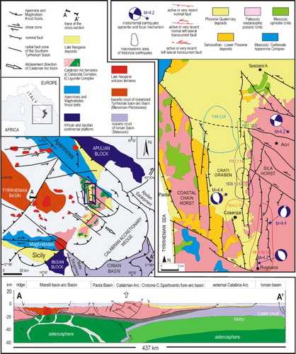
Figure 2. Kinematic scheme of the study area.
2. Methodology
On the map we depict recent and active faults obtained through geo-structural and geomorphological analysis, performed from the macro to the mesoscale. The macro-structural analysis has been carried out by aerial photographic interpretation which led to the identification of morpho-tectonic indicators such as fault scarps and triangular/trapezoidal facets. Other indicators are rectified waterways and morphological steps and saddles aligned along adjacent ridges. Along the faults recognized at the macroscale, we performed meso-structural studies (CitationHancock, 1985) collected at 52 stations located along the main fault zones. The most recent faults have been detailed, closely associated with the morphodynamics recognizable in the current landscape and with the seismotectonic setting of the area. The meso-structural data were collected at measuring stations uniformly distributed along the faults. For each striated fault plane we measured strike, dip and pitch, and so determined the direction of movement. The most representative elements of gravitational and tectono-gravitational origin have been recognized primarily using geomorphological criteria (detection of scarps and trenches along the ridges and on the slopes, the analysis of the shape of the latter and interference with the drainage network, etc.) and multi-temporal analysis of aerial photographs and satellite images followed by field surveys. We also report the outcropping lithologies. The synthesis of the above-mentioned studies led to the mapping (1:10,000). Quaternary faults have been recognized and mapped on the basis of Quaternary deposit displacements and on the morpho-tectonic evidences together with scarps related to cumulative and triangular facets and trapezoidal, as well as the relationships between faults and large landslides (LL) and deep-seated gravitational deformations.
The above data were then digitized and analysed in a geographic information system. The data were geo-referenced in UTM (Universal Transverse Mercator) with WGS84 Datum.
3. Lithostratigraphy
In the study area, the following main tectono-stratigraphic and tectono-metamorphic units () crop out, on which Neogene-Quaternary strata lie unconformably.
Figure 3. Tectonic scheme (not to scale) comprising the structural assemblage of the Calabrian belt.
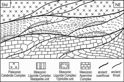
The units are briefly described from bottom to top.
Tectonic units of the Chain
Carbonate-Apennine Complex
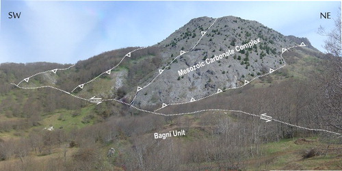
Prevalent Triassic dolostone and metalimestone (Monte Cocuzzo Unit), outcropping in ‘tectonic windows’ along the southern edge of the Coastal Chain horst, and Mesozoic to Langhian succession constituted by phyllites, metalimestone, dolostone and calcarenites and marls, with turbiditic strata (Lungro-Verbicaro Unit) (CitationIannace et al., 2007), outcropping in the north-western extremity of the study area.
Ophiolite Units
Metabasalts and pillow breccia with a Calpionella limestone sequence cover (Malvito Unit) and massive and foliated metabasite and serpentinite, with metapelite and metalimestone cover (Diamante-Terranova Unit; CitationCritelli, 1993). They crop out diffusely along the Coastal Chain (CitationFilice et al., 2015) and in the NE extremity of the map.
Paleozoic metamorphic – plutonic units
A number of tectonic units belonging to the Calabrian Arc – diffusely outcropping along the Coastal Chain and Sila Massif – are constituted, from bottom to top, by:
dominantly foliated slates, black metapelites and metasilts, interbedded with micaschists and porphyroids (Bagni Unit),
milonitic gneiss, micaschists and marbles (Castagna Unit),
high-grade metamorphic rocks (biotite-sillimanite-garnet gneiss), intruded by plutonic bodies (Monte Gariglione-Polia Copanello Unit), and
Intrusive bodies of regional extension with variable composition from gabbro to tonalite, granodiorite and monzogranite intruded by felsic dykes, microgranite and aplite-pegmatite (Sila Batholith).
3.1. Neogene-Quaternary deposits
Neogene transgressive deposits – outcrop along the western and eastern borders of the Coastal Chain – made up of Serravallian conglomerate-arenite, Tortonian mixed arenites (Calcare di Mendicino Formation) passing upwards to clay with shelf turbidites and thin bedded diatomites and marls (CitationLanzafame & Zuffa, 1976; CitationMastandrea et al., 2002; CitationMattei et al., 2002). Messinian deposits consist of evaporite and terrigenous strata and mainly outcrop to the NE margin of the map, in the area comprised between the Rosa River and the Grondo River (). They consist of calcarenite and clayey and arenaceous strata passing to thin laminated limestones alternated with vacuolar limestones. The succession grades upwards into clay with thin laminated gypsum strata, in which are intercalated thick levels of halite. The Messinian succession of the Crati Basin is partially correlated to the evaporite deposits of the Crotone Basin (CitationZecchin et al., 2013a, Citation2013b and references therein) and to the Messinian infill of the Amantea Basin (CitationLonghitano & Nemec, 2005; CitationMattei et al., 2002; CitationMuto & Perri, 2002). Conglomerate–sand–clay succession, unconformably overlies the above-mentioned Miocene units. Middle Pliocene to Middle Pleistocene deposits, made of thick conglomerate–sand–sandstone–lay marine succession (), represent the basin-fill deposits of the Crati Graben (CitationFabbricatore et al., 2014; CitationLanzafame & Tortorici, 1981). The stratigraphic succession of the Crati Basin is generally divided into two sequences. The first unit consists of Lower Pliocene deposits unconformably overlying the bedrock and the Messinian formations, cropping out exclusively in the western margin of the basin. In this zone the Neogene-Quaternary deposits are displaced by N–S trending normal faults with respect to the metamorphic units of the Coastal Chain. The lower sequence consists of conglomerates and sandstones passing upward into silty clays and clays (CitationBurton, 1971; CitationLanzafame & Tortorici, 1981; CitationLanzafame & Zuffa, 1976; CitationSpina et al., 2011; CitationTortorici, 1981). The second unit unconformably lies either on the first unit or directly onto the bedrock in the eastern margin of the basin (CitationFabbricatore et al., 2014). The Pleistocene sequence represents the sedimentary response to the basin subsidence and the uplift of the margins. In this time the Crati Basin shows the tectono-sedimentary architecture of a fault bounded intra-arc depozone cut to the north and south by transversal major faults while, to the east and west, by longitudinal major normal faults. Further, sedimentation proceeds eastwards, causing a diachronous transgression, propagating the progressive onlap on the western Sila Massif slope. The deposits are constituted of conglomerates, sandstones and mixed arenites mostly belonging to deltaic and coastal deposits (CitationCarobene & Damiani, 1985; CitationColella, 1988; CitationColella, De Boer, & Nio, 1987; CitationFabbricatore et al., 2014) and compare to the same coeval successions of other basins bordering the eastern and southern margins of the Sila Massif (CitationCorbi et al., 2009; CitationLonghitano, Chiarella, & Muto, 2014; CitationMuto et al., 2015; CitationZecchin et al., 2012, Citation2013a, Citation2013b, Citation2015). Starting from Middle Pleistocene, northern Calabria experienced a marked uplift (CitationTortorici, 1981; CitationWestaway, 1993) that caused the deformation of the Lower Pleistocene deposits and the accumulation of a 40 m thick succession of fluvial conglomerate well exposed in the western margin of the Crati Basin; a comparable stratigraphic succession is found on the eastern side of the Sila Massif (CitationCorbi et al., 2009; CitationRobustelli et al., 2009). A series of piedmont alluvial fans and marine terraces, are formed in response to the late Pleistocene uplift of the entire Coastal Range-Sila Massif and Crati Valley system. These deposits are carved into the substrate of the older successions of the Crati Basin infill, of the Tyrrhenian margin of the Coastal Range (CitationMuto, Robustelli, Scarciglia, Spina, & Critelli, 2003; CitationRobustelli, Muto, Scarciglia, Spina, & Critelli, 2005) and of the eastern Sila margin (CitationCarobene, 2003; CitationFerranti, Santoro, Mazzella, Monaco, & Morelli, 2009; CitationMolin, Dramis, Lupia, & Palmieri, 2002; CitationRobustelli et al., 2009). Holocene alluvial fan deposits crop out in the Crati River valley and along the subsidiary transverse valleys.
4. Tectonic structures
The Crati Graben is a Pliocene-Holocene tectonic depression, mainly structured by N–S trending normal faults and filled by marine and continental clastic deposits (). On its western and eastern sides, the graben is bounded by Palaeozoic crystalline-metamorphic rocks of the Coastal Chain and the Sila Massif horsts, respectively. Regional NW–SE normal left-lateral faults border the Crati Graben in the southern and northern margins (CitationTansi et al., 2007; CitationVan Dijk et al., 2000). From a morphological perspective the faults are characterized by a remarkable ‘freshness’, by displacements of Quaternary deposits and are represented on the Main Map, together with structural data at the mesoscale.
4.1. N–S normal fault system
Morphologically, these faults are represented by sharp rectilinear escarpments, marked by active alluvial fans, bounding the uplifted footwalls. The mountain fronts reach elevations of about 700 m, and are characterized by 300–400 m high cumulative fault escarpments along which triangular/trapezoidal facets (70–100 m high) are found. An antecedent drainage network flows perpendicular to the fault segments; it is made of deeply entrenched canyons on the uplifted blocks, and of flat valleys on the down-thrown blocks (CitationTansi et al., 2005a; CitationTortorici, Monaco, Tansi, & Cocina, 1995). Along some fault scarps, broken ridges documenting also a transcurrent right-handed component of motion are recognizable.
At the mesoscopic-scale, fault planes strike from N160E to N25E, and dip 60°–80° mostly towards the west. The planes of this fault system are characterized by sub-vertical inclination and dip-slip to oblique slickensides: pitches indicate a lateral component of displacement, progressively evolving from strongly left to moderately right (see the Main Map). The meso-structural data indicate overall a direction of late extension oriented on average WNW–ESE.
4.2. NW–SE transcurrent and normal-transcurrent left-lateral fault system
The faults of the NW–SE-oriented system are characterized by transcurrent and oblique left-lateral kinematics, mainly dip towards NE, and present mean directions N120E (field variability N100E–N140E) and sub-vertical planes (average inclination 70°–80°). Furthermore, vertical displacements of these faults are significantly lower than those of the N–S and extremely variable, as evidenced by triangular facets and/or trapezoidal and by the cumulative fault scarps (height between 0 and 300 m). At the mesoscale, fault planes strike from N120E to N145E, and show sub-vertical dip mostly towards NE in the southern side (Carpanzano-Falconara, in CitationVan Dijk et al., 2000) and dip towards SW to the northern Pollino fault. Planes are characterized by sub-horizontal slickensides documenting left-lateral transcurrent motions, supporting a direction of late compression oriented on average E–W.
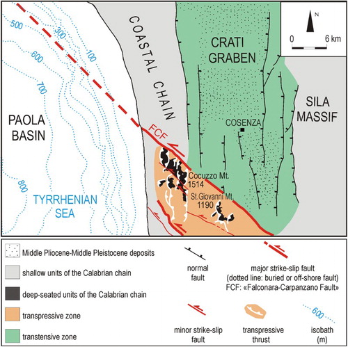
4.3. Transpressive thrusts
The Mt. Cocuzzo and Mt. San Giovanni carbonate outcrops are two transpressional push-ups bordered by left-lateral trascurrent faults, penetrating the overlying Calabrian Terranes (e.g. CitationTansi et al., 2007).
The thrust ramps building the Mt. Cocuzzo push-up depict, as a whole, well-developed flower structures some of which portray positive flower structures ().
Figure 4. Panoramic view, from the south, of the Cocuzzo Mt. push-up (modified after CitationTansi et al., 2007).
At the mesoscopic-scale, transpressive thrust planes strike roughly NNE–SSW, and dip from 45° to 80° towards either E or W. Thrust planes show dip-slip to oblique slickensides, documenting reverse movements and a sub-horizontal σ1-oriented WNW–ESE (CitationTansi et al., 2007).
4.4. Ancient thrusts
In both the Mt. Cocuzzo and the Mt. San Giovanni push-ups, ancient thrusts – characterized by sub-horizontal planes striking E–W to WNW–ESE – were also recognized. These thrusts do not show any morphological evidence, and are documented only at the mesoscale (where they are commonly dislocated by the N–S oriented thrusts which build the push-ups). These planes display reverse dip-slip slickensides, documenting – if tilting is ignored – a N–S oriented sub-horizontal σ1: they can be related to the overthrusts responsible for the Oligocene-Early Miocene building of the chain.
5. Seismotectonics
The Crati Graben corresponds to the epicentral zone of significant instrumental (3 > M > 5, years 1983–2014 – after INGV) and historical earthquakes (Imax up to X MCS; after CitationBoschi et al., 1995). As regards historical seismicity, the area was affected by six earthquakes with Imax = VIII–X MCS: five of them (occurring in 1184, 1767, 1835, 1854, 1870, and 1887) show epicentral areas located along the eastern border of the Crati Graben, and one earthquake (occurring in 1184, characterized by a more uncertain location) along its western border ().
In particular, as regards the epicentres of the main shocks (cf. events of 1835, 1854, and 1870, Imax = X MCS, which were responsible for ∼800 deaths), these are located in the southernmost sector of the map, with a progressive migration towards the south. The axis of elongation of the macroseismic zones related to the above-mentioned earthquakes coincide with the principal (and most recent) N-S faults. As regards the earthquake of 1184, informations on the number of deaths and the epicentral area are very poor, although the fragmentary historical informations refer to a thousand victims (see ).
Table 1. Main historical earthquakes occurred in the study area.
Moreover, the focal mechanisms of 18 October 2001 (M = 4.2), 20 February 1980 and 28 December 2014 earthquakes (both M = 4.4) confirm, on the basis of fault planes solutions, the activity of N–S faults, while the focal mechanism of the 24 April 1996 (M = 4.2) earthquake points to activity of the NW–SE faults.
6. Gravitational and tectono-gravitational phenomena
The study area is characterized by the widespread instability of slopes. These phenomena, of various types and sizes (CitationCruden & Varnes, 1996), are determined by the particular geodynamic context that displays gravitational energy (produced by tectonic uplift occurring in the Calabrian Arc), the degree of fracturing of the rock types involved in the tectonic deformations and the particular structural styles predisposing the slopes to instability.
As a result, the Province of Cosenza, in 2012, signed with the Research Institute for Hydrogeological Protection of the Italian National Research Council (CNR-IRPI) a Convention for mapping the geo-hydrology of risk areas. This study is part of the results of the Convention. The Main Map summarizes the efforts to integrate available databases with original surveying, trying to respect the original classifications. In particular, on the map were distinguished the following groups of gravitational and tectono-gravitational phenomena. Slide, flow, fall, complex, deep-seated gravitational slope deformation, shallow landslide area, deep landslide area, and, in addition, area of erosion.
In addition, landforms were distinguished based on the period of activation as follows:
Landslides activated in the period 2008–2012 that affected residential areas (with more than 200 inhabitants) and roads.
Landslides before 2000 affecting residential areas and roads collected by Basin Authority (BA) of Region of Calabria (Hydrogeological Plan For Soil Protection – PAI – of the Region of Calabria, Italy. CitationAutorità di Bacino della Calabria, 2001). They are differentiated as dormant or active, and distinguished in the same typologies of the above class in addition to Falls and Deep-seated gravitational slope deformations (DGSD).
LL, gravitational and tectono-gravitational slope deformations (after CitationAutorità di Bacino della Calabria, 2001; CitationSorriso-Valvo & Tansi, 1996; CitationTansi, Iovine, & Folino Gallo, 2005b). They are distinguished as Slide, flow, complex, LL, Sackung (SK), and lateral spreading (LS).
Deep-seated gravitational and tectono-gravitational accommodation wedge (Gravity-accommodated structural wedges, GASW, CitationIovine & Tansi, 1998)
Tectono-gravitational trench (CitationIovine & Tansi, 1998; CitationSorriso-Valvo & Tansi, 1996).
The following tables summarize the results of statistical analysis on the different types of the analysed mass movements. In particular, shows the statistical data on the landslides activated in the period 2008–2012, with 2440 landslides in total (area: 27.5 km2), of which the most frequent typology is ‘slide’ (1433), while the more extensive are the ‘landslide areas’, involving both ‘shallow landslide areas’ and ‘medium-deep landslide areas’ (CitationAutorità di Bacino della Calabria, 2001). Of this total, 91.3% of landslides (2228 over 23.88 km2) affects the Crati Graben; these landslides are, on the whole, rather widespread along its two margins, in correspondence with the main faults responsible for the tectonic contact between the Palaeozoic-Mesozoic rocks of Coastal Chain and Sila Massif horsts and the Pliocene-Pleistocene sedimentary deposits filling the Crati Graben. It also evidences the control of faults on the distribution of landslides: 51% (1243) of the landslides originate in the cataclastic bands associated with the main faults, that were localized on their footwall and estimated to be 300 m thick. The landslides occurring along the western edge of the Crati Graben occupy an area about three times greater than the eastern edge (16.88 km2 versus 7.0 km2), although the total number of phenomena are similar (1135 versus1093 landslides).
Table 2. Statistical data on the landslides activated in the period 2008–2012 (total area of the map: 2039.7 km2).
A comparison of the data collected by the BA of the Region of Calabria – relating to information prior to 2001, shows a large number of landslides activated in the period 2008–2012 (1513 for a total area of 15.12 km2) affecting areas classified by BA as dormant landslides. In other cases, some landslides indicated by BA as having significantly increased their surface area (927, 38 %) with recent landslides occurring in areas not surveyed by BA.
shows the statistical data on the LL and gravitational and tectono-gravitational slope deformations: LL, GASW, SK and LS.
Table 3. Statistical data on the LL and gravitational and tectono-gravitational slope deformations (total area of the map: 2039.7 km2).
These phenomena are found along both the western and eastern borders of the Crati Graben, where high relief energy and steep slopes are commonly associated with severe tectonic fracturing, such as deep weathering profiles of crystalline rocks (e.g. CitationBorrelli, Perri, Critelli, & Gullà, 2012, Citation2014; CitationBorrelli, Critelli, Gulla, & Muto, 2015a; CitationBorrelli, Coniglio, Critelli, La Barbera, & Gullà, 2015b). A total sample of 88 phenomena (LL, GASW, SK, and LS) were recognized and depicted on the map involving 200.65 km2 corresponding to 9.85% of the surveyed area. These tipologies of phenomena are generally developed within the pre-Miocene bedrock outcropping in the footwall of the major faults (i.e. Coastal Range) and are bounded by N–S or NW–SE normal faults or transpressive thrust ramps.
7. Conclusions
The Crati Graben is mainly controlled by extensional N–S striking faults and WNW–ESE transcurrent faults at its northern and southern end. The comparison of the data testifies to a correlation between tectonic structures and areas affected by landslides. The recent and active faults were compared with historical and instrumental seismicity, in order to identify the main seismogenic structures. In historical time, numerous severe crustal earthquakes (VIII–X MCS) occurred in the Crati Graben; present seismicity confirms its seismogenic character related to fault activity dominantly into the eastern margin of the basin. The seismological, geo-structural and geomorphological analysis was performed in a geographic information system. In conclusion, we produced an updated knowledge framework of risk conditions of the whole province, where the risk areas are hierarchically classified according to the destructive potential of landslides. The large-scale seismotectonic and landslides map may represent a useful tool for territorial engineering-geological planning and Civil Protection.
Software
The topographic basemap, the landslide inventory map and related layout were drafted using the software open source QGIS. Data collected, using previous geological and geomorphological information, air photo interpretation, topographic maps and field survey, were geo-referenced and digitized and a database containing attributes of the main features observed was created for each mapped landform. Adobe Illustrator CS3/CS4 was used to produce the final layout of the map.
Seismotectonic and landslides of the Crati Graben (Calabrian Arc, Southern Italy).pdf
Download PDF (13 MB)Acknowledgments
The present paper represents the results of a scientific collaboration between the Italian National Research Council – Research Institute for Geo-Hydrological Protection (CNR-IRPI) and the Province of Cosenza. The authors are grateful to Jenny Bernhard, Francesco Dramis and Kurt Katzenstein for their suggestions and comments.
Disclosure statement
No potential conflict of interest was reported by the authors.
Additional information
Funding
References
- Amodio-Morelli, L., Bonardi, G., Colonna, V., Dietrich, D., Giunta, G., Ippolito, F., … Zuppetta, A. (1976). L’arco Calabro-Peloritano nell’orogene appenninico Maghrebide (The Calabrian-Peloritan Arc in the Apennine-Maghrebide orogen). Memorie della Società Geologica Italiana, 17, 1–60.
- Argnani, A., & Trincardi, F. (1990). Paola slope basin: Evidence of regional contraction on the eastern Tyrrhenian margin. Memorie della Società Geologica Italiana, 44, 93–105.
- Autorità di Bacino della Calabria. (2001). Piano Stralcio per l’Assetto Idrogeologico (PAI). Regione Calabria, Catanzaro.
- Borrelli, L., Critelli, S., Gulla, G., & Muto, F. (2015a). Weathering grade and geotectonics of the western-central Mucone River basin (Calabria, Italy). Journal of Maps, 11(4), 606–624. doi: 10.1080/17445647.2014.933719
- Borrelli, L., Coniglio, S., Critelli, S., La Barbera, A., & Gullà, G. (2015b). Weathering grade in granitoid rocks: The San Giovanni in Fiore area (Calabria, Italy). Journal of Maps, 1–16. doi:10.1080/17445647.2015.1010742.
- Borrelli, L., Perri, F., Critelli, S., & Gullà, G. (2012). Minero-petrographical features of weathering profiles in Calabria, southern Italy. Catena, 92, 196–207. doi: 10.1016/j.catena.2012.01.003
- Borrelli, L., Perri, F., Critelli, S., & Gullà, G. (2014). Characterization of granitoid and gneissic weathering profiles of the Mucone river basin (Calabria, southern Italy). Catena, 113, 325–340. doi: 10.1016/j.catena.2013.08.014
- Boschi, E., Ferrari, G., Gasperini, P., Guidoboni, E., Smriglio, G., & Valensise, G. (1995). Catalogo dei forti terremoti in Italia dal 461 A.C. al 1980 (Strong earthquakes in Italy from 461 B.C. to 1980), n. 1 CD-ROM. ING and SGA, Roma, 973 pp.
- Boschi, E., Guidoboni, E., Ferrari, G., Valensise, G., & Gasperini, P. (1997). Catalogo dei forti terremoti in Italia dal 461 A.C. al 1990, vol. 2 (Strong earthquakes in Italy from 461 B.C. to 1990, vol. 2), n. 1 CD-ROM. ING and SGA, Roma, 644 pp.
- Bousquet, J. C. (1971). La tectonique tangentielle des séries calcaires dolomitiques du Nord-Est de l’Apennin Calabro-Lucanien (Italie Meridionale). Geologica Romana, X, 23–51.
- Burton, A. N. (1971). Carta Geologica della Calabria alla scala di 1:25.000. Relazione generale Cassa per il Mezzogiorno. Servizio Bonifiche Roma, 120 pp.
- Carobene, L. (2003). Genesi, età sollevamento ed erosione dei terrazzi marini di Crosia-Calopezzati (costa ionica della Calabria-Italia). Il Quaternario, Italian Journal of Quaternary Science, 16(1), 43–90.
- Carobene L., & Damiani, A. V. (1985). Tettonica e sedimentazione pleistocenica nella media Valle del F. Crati (Calabria). Bollettino della Società Geologica Italiana, 104, 93–114.
- Colella, A. (1988). Pliocene-holocene fan deltas and braid deltas in the Crati Basin, southern Italy: A consequence of varying tectonic conditions. In W. Nemec & R. J. Steel (Eds.), Fan deltas: Sedimentology and tectonic setting (pp. 50–74). London: Blackie and Son.
- Colella, A., De Boer, P. L., & Nio, S. D. (1987). Sedimentology of a marine intermontane Pleistocene Gilbert-type fan-delta complex in the Crati Basin, Calabria, Southern Italy. Sedimentology, 34, 721–736. doi: 10.1111/j.1365-3091.1987.tb00798.x
- Conforti, M., Muto, F., Rago, V., & Critelli, S. (2014). Landslide inventory map of north-eastern Calabria (South Italy). Journal of Maps, 10(1), 90–102. doi: 10.1080/17445647.2013.852142
- Corbi, F., Fubelli, G., Lucà, F., Muto, F., Pelle, T., Robustelli, G., Scarciglia, F., & Dramis, F. (2009). Vertical movements in the Ionian margin of the Sila Massif (Calabria, Italy). Italian Journal of Geosciences, 128(3), 731–738. doi:10.3301/IJG.2009.128.3.731.
- Critelli, S. (1993). Sandstone detrital modes in the Paleogene Liguride Complex, accretionary wedge of the Southern Apennines (Italy). Journal of Sedimentary Petrology, 63, 464–476.
- Critelli, S., & Le Pera, E. (1995). Tectonic evolution of the Southern Apennines thrust-belt (Italy) as reflected in modal compositions of Cenozoic sandstone. The Journal of Geology, 103, 95–105. doi: 10.1086/629725
- Critelli, S., Muto, F., Tripodi, V., & Perri, F. (2011). Relationships between lithospheric flexure, thrust tectonics and stratigraphic sequences in foreland setting: The southern Apennines foreland basin system, Italy. In Schattner, U. (Ed.), New frontiers in tectonic research – at the midst of plate convergence (pp. 121–170). Rijeka: Tech Open Access.
- Critelli, S., Muto, F., Tripodi, V., & Perri, F. (2013). Link between thrust tectonics and sedimentation processes of stratigraphic sequences from the southern Apennines foreland basin system, Italy. Rendiconti Online Società Geologica Italiana, 25, 21–42.
- Cruden D. M., & Varnes, D. J. (1996). Landslide types and processes. In A. K. Turner & R. L. Schuster (Eds.), Landslides: Investigation and mitigation (pp. 36–75). Special Report, 247, Washington, DC: Transportation Research Board, National Research Council, National Academy Press.
- Dewey, J. F., Helman, M. L., Turco, E., Hutton, D. W. H., & Knott, S. D. (1989). Kinematics of the Western Mediterranean. In M. P. Coward, D. Dietrich, & G. Park (Eds.), Alpine tectonics. Geological society of London special publication (vol. 45, pp. 265–283). London: Geological Society of London.
- Doglioni, C. (1991). A proposal of kinematic modelling for W-dipping subductions. Possible applications to the Tyrrhenian–Apennines system. Terra Nova, 3, 423–434. doi: 10.1111/j.1365-3121.1991.tb00172.x
- Fabbricatore, D., Robustelli, G., & Muto, F. (2014). Facies analysis and depositional architecture of shelf-type deltas in the Crati Basin (Calabrian Arc, south Italy). Italian Journal of Geosciences, 133:131–148. doi: 10.3301/IJG.2013.19
- Ferranti, L., Santoro, E., Mazzella, M. E., Monaco, C., & Morelli, D. (2009). Active transpression in the northern Calabria Apennines, southern Italy. Tectonophysics, 476, 226–251. doi: 10.1016/j.tecto.2008.11.010
- Filice, F., Liberi, F., Cirillo, D., Pandolfi, L., Marroni, M., & Piluso, E. (2015). Geology map of the central area of Catena Costiera: Insights into the tectono-metamorphic evolution of the Alpine belt in Northern Calabria. Journal of Maps, 11(1), 114–125. doi: 10.1080/17445647.2014.944877
- Ghisetti, F., & Vezzani, L. (1981). Contribution of structural analysis to understanding the geodynamic evolution of the Calabrian Arc (southern Italy). Journal of Structural Geology, 3, 371–381. doi: 10.1016/0191-8141(81)90037-7
- Hancock, P. L. (1985). Brittle microtectonics: Principles and practice. Journal of Structural Geology, 7, 437–457. doi: 10.1016/0191-8141(85)90048-3
- Iannace, A., Vitale, S., D’Errico, M., Mazzoli, S., Distaso, A., Macaione, E., … Bonardi, G. (2007). The carbonate tectonic units of northern Calabria (Italy): A record of Apulian palaeomargin evolution and Miocene convergence, continental crust subduction, and exhumation of HP-LT rocks. Journal of the Geological Society, London, 164, 1165–1186. doi: 10.1144/0016-76492007-017
- Iovine, G., & Tansi, C. (1998). Gravity-accommodated ‘structural wedges’ along thrust ramps: A kinematic scheme of gravitational evolution. Natural Hazards, 17, 195–224. doi: 10.1023/A:1008078217930
- Kastens, K., Mascle, J., Auroux, C., Bonatti, E., Broglia, C., Channell, J., … Tori, M. (1988). ODP Leg 107 in the Tyrrhenian sea: Insights into passivemargin and back-arc basin evolution. Geological Society of America Bulletin, 100, 1140–1156. doi: 10.1130/0016-7606(1988)100<1140:OLITTS>2.3.CO;2
- Lanzafame, G., & Tortorici, L. (1981). La tettonica recente del Fiume Crati (Calabria). Geografia Fisica e Dinamica Quaternaria, 4, 11–21.
- Lanzafame, G., & Zuffa, G. G. (1976). Geologia e petrografia del Foglio di Bisignano (Bacino del Crati, Calabria). Geologica Romana, 15, 223–270.
- Longhitano, S. G., Chiarella, D., & Muto, F. (2014). Three-dimensional to two-dimensional cross-strata transition in the lower Pleistocene Catanzaro tidal strait transgressive succession (southern Italy). Sedimentology, 61, 2136–2171. doi: 10.1111/sed.12138
- Longhitano, S. G., & Nemec, W. (2005). Statistical analysis of bed-thickness variation in a Tortonian succession of biocalcarenitic tidal dunes, Amantea Basin, Calabria, southern Italy. Sedimentary Geology, 179, 195–224. doi: 10.1016/j.sedgeo.2005.05.006
- Malinverno, A., & Ryan, W. B. F. (1986). Extension in the Tyrrhenian sea and shortening in the apennines as result of arc migration driven by sinking of the lithosphere. Tectonics, 5, 227–245. doi: 10.1029/TC005i002p00227
- Mastandrea, A., Muto, F., Neri, C., Papazzoni, C. A., Perri, E., & Russo, F. (2002). Deep-water coral banks: An example from the ‘Calcare di Mendicino’ (Upper Miocene, Northern Calabria, Italy). Facies, 47, 27–42. doi: 10.1007/BF02667704
- Mattei, M., Cipollari, P., Cosentino, D., Argentieri, A., Rossetti, F., & Speranza, F. (2002). The Miocene tectonic evolution of the southern Tyrrhenian Sea: Stratigraphy, structural and paleomagnetic data from the on-shore Amantea Basin (Calabrian arc, Italy). Basin Research, 14, 147–168. doi: 10.1046/j.1365-2117.2002.00173.x
- Milia, A., Turco, E., Pierantoni, P. P., & Schettino, A. (2009). Four-dimensional tectonostratigraphic evolution of the Southeastern peri-Tyrrhenian basins (Margin of Calabria, Italy). Tectonophysics, 476, 41–56. doi: 10.1016/j.tecto.2009.02.030
- Molin, P., Dramis, F., Lupia, & Palmieri, E. (2002). The Pliocene-Quaternary uplift of the Ionian northern Calabria coastal belt between Corigliano Calabro and Capo Trionto. Studi Geologici Camerti, 135–145, Volume Speciale (Special Issue).
- Moretti, A., Corea, I., & Guerra, I. (1990). Sismicità attuale e sistemi di fratture superficiali in Calabria. Atti del Convegno GNDT, 1, 89–101.
- Muto, F., Critelli, S., Robustelli, G., Tripodi, V., Zecchin, M., Fabbricatore, D., & Perri, F. (2015). A Neogene-Quaternary geotraverse within the northern Calabrian Arc from the foreland peri-Ionian margin to the back-arc Tyrrhenian margin. Geological Field Trips, 7(2.2), 65. doi:10.3301/GFT.2015.04.
- Muto, F., & Perri, E. (2002). Evoluzione tettono-sedimentaria del bacino di Amantea, Calabria occidentale (Tectonic-sedimentary evolution of the Amantea basin, western Calabria). Bollettino della Società Geologica Italiana, 121, 1–19.
- Muto, F., Robustelli, G., Scarciglia, F., Spina, V., & Critelli, S. (2003). Geomorphology, tectonics and sedimentology of Late Quaternary fans between Guardia Piemontese and Paola (Tyrrhenian coast of Calabria, Southern Italy). Il Quaternario, Italian Journal of Quaternary Sciences, 16, 217–229.
- Muto, F., Spina, V., Tripodi, V., Critelli, S., & Roda, C. (2014). Neogene tectonostratigraphic evolution of allochthonous terranes in the eastern Calabrian foreland (southern Italy). Italian Journal of Geosciences, 133, 455–473. doi: 10.3301/IJG.2014.23
- Ogniben, L. (1969). Schema introduttivo alla geologia del confine calabro-lucano (Introductory scheme to the geology of the Calabrian-Lucanian boundary). Memorie della Società Geologica Italiana, 8, 453–763.
- Ogniben, L. (1973). Schema geologico della Calabria in base ai dati odierni. Geologica Romana, 12, 243–585.
- Patacca, E., & Scandone, P. (1989). Post-Tortonian mountain building in the Apennines. The role of the passive sinking of a relic lithospheric slab. In Boriani, A., Bonafede, M., Piccardo, G. B., Vai, G. B. (Eds.), The Lithosphere in Italy. Advances in Earth Science Research. Italian Nature Communication. International Lithosphere Program, Mid-term Conf. (Rome, May 5–6, 1987). Atti Conv. Lincei 80, pp. 157–176.
- Pepe, F., Sulli, A., Bertotti, G., & Cella, F. (2010). Architecture and Neogene to recent evolution of the western Calabrian continentalmargin: An upper plate perspective to the Ionian subduction system, central Mediterranean. Tectonics, 29, TC3007. doi:10.1029/2009TC002599.
- Postpischl, D. (1985). Catalogo dei forti terremoti italiani dall’anno 1000 al 1980 (Catalogue of strong Italian earthquakes from a.D. 1000 to 1980). CNR, Progetto Finalizzato Geodinamica, Graficcop, Bologna, 239 pp.
- Robustelli, G., Lucà, F., Corbi, F., Pelle, T., Dramis, F., Fubelli, G., … Cugliari D. (2009). Alluvial terraces on the Ionian coast of northern Calabria, southern Italy: Implications for tectonic and sea level controls. Geomorphology, 106, 165–179. doi: 10.1016/j.geomorph.2008.12.010
- Robustelli, G., Muto, F., Scarciglia, F., Spina, V., & Critelli, S. (2005). Eustatic and tectonic control on late quaternary alluvial fans along the Tyrrhenian Sea cost of Calabria (South Italy). Quaternary Science Review, 24, 2101–2119. doi: 10.1016/j.quascirev.2004.08.025
- Royden, L., Patacca, E., & Scandone, P. (1987). Segmentation and configuration of subducted lithosphere in Italy: An important control on thrust belt and foredeep basin evolution. Geology, 15, 714–717. doi: 10.1130/0091-7613(1987)15<714:SACOSL>2.0.CO;2
- Sartori, R. (1990). The main results of OPD Leg 107 in the frame of Neogene to Recent geology of peri-Tyrrhenian areas. In: Kastens, K. A., Mascle, J., et al. (Eds.), Proceedings of the Ocean Drilling Program. Scientific Results vol. 107. Ocean Drilling Program, College Station, Texas, pp. 715–730.
- Sorriso-Valvo, M., & Tansi, C. (1996). Grandi frane e deformazioni gravitative profonde di versante della Calabria – Note illustrative per la carta al 250.000. Geografia Fisica e Dinamica Quaternaria, 19, 395–408.
- Spina, V., Tondi, E., & Mazzoli, S. (2011). Complex basin development in a wrench-dominated back-arc area: Tectonic evolution of the Crati Basin, Calabria, Italy. Journal of Geodynamics, 51, 90–109. doi: 10.1016/j.jog.2010.05.003
- Tansi, C., Iovine, G., & Folino Gallo, M. (2005a). Tettonica attiva e recente, e manifestazioni gravitative profonde, lungo il bordo orientale del graben del Fiume Crati (Calabria Settentrionale) (Present and recent tectonics, and deep-gravitational phenomena, along the eastern boundary of the R. Crati graben (Northern Calabria)). Bollettino della Società Geologica Italiana, 124(3), 563–578.
- Tansi, C., Iovine, G., Folino Gallo, M. (2005b). Tettonica attiva e recente, manifestazioni gravitative profonde, lungo il bordo orientale del graben del Fiume Crati (Calabria settentrionale). Bollettino della Società Geologica Italiana, 124(3), 563–578.
- Tansi, C., Muto, F., Critelli, S., & Iovine, G. (2007). Neogene–Quaternary strike-slip tectonics in the central Calabrian Arc (southern Italy). Journal of Geodynamics, 43, 393–414. doi: 10.1016/j.jog.2006.10.006
- Tortorici, L. (1981). Analisi delle deformazioni fragili dei sedimenti postorogeni della Calabria settentrionale. Bollettino della Società Geologica Italiana, 100, 291–308.
- Tortorici, L. (1982). Lineamenti geologico-strutturali dell’Arco Calabro Peloritano (Geologic-structural lineaments of the Calabrian-Peloritan Arc). Societa’ Italiana di Mineralogia e Petrografia, 38, 927–940.
- Tortorici, L., Monaco, C., Tansi, C., & Cocina, O. (1995). Recent and active tectonics in the Calabrian Arc (southern Italy). Tectonophysics, 243, 37–55. doi: 10.1016/0040-1951(94)00190-K
- Tripodi, V., Muto, F., & Critelli, S. (2013). Structural style and tectono-stratigraphic evolution of the Neogene Quaternary Siderno basin, southern Calabrian Arc, Italy. International Geology Review, 55, 468–481. doi: 10.1080/00206814.2012.723859
- Turco, E., Maresca, R., & Cappadona, P. (1990). La tettonica plio-pleistocenica del confine calabro-lucano: modello cinematico (Plio-Pleistocene tectonics at the Calabrian-Lucanian boundary: A kinematic model). Memorie della Società Geologica Italiana, 45, 519–529.
- Van Dijk, J. P., Bello, M., Brancaleoni, G. P., Cantarella, G., Costa, V., Frixa, A., … Zerilli, A. (2000). A regional structural model for the northern sector of the Calabrian Arc (southern Italy). Tectonophysics, 324, 267–320. doi: 10.1016/S0040-1951(00)00139-6
- Vespasiano, G., Apollaro, C., Muto, F., Dotsika, E., De Rosa, R., & Marini, L. (2014). Chemical and isotopic characteristics of the warm and cold waters of the Luigiane Spa near Guardia Piemontese (Calabria, Italy) in a complex faulted geological framework. Applied Geochemistry, 41, 73–78. doi: 10.1016/j.apgeochem.2013.11.014
- Westaway, R. (1993). Quaternary uplift of Southern Italy. Journal of Geophysical Research: Solid Earth, 98, 21.741–21.772. doi: 10.1029/93JB01566
- Zecchin, M., Caffau, M., Civile, D., Critelli, S., Di Stefano, A., Maniscalco, R., … Roda, C. (2012). The Plio-Pleistocene evolution of the Crotone Basin (southern Italy): Interplay between sedimentation, tectonics and Eustasy in the frame of Calabrian Arc migration. Earth-Science Reviews, 115, 273–303. doi: 10.1016/j.earscirev.2012.10.005
- Zecchin, M., Caffau, M., Di Stefano, A., Maniscalco, R., Lenaz, D., Civile, D., … Critelli, S. (2013a). The Messinian succession of the Crotone Basin (southern Italy) II: Facies architecture and stratal surfaces across the Miocene–Pliocene boundary. Marine and Petroleum Geology., 48, 474–492. doi: 10.1016/j.marpetgeo.2013.08.013
- Zecchin, M., Civile, D., Caffau, M., Muto, F., Di Stefano, A., Maniscalco, R., & Critelli, S. (2013b). The Messinian succession of the Crotone Basin (southern Italy) I: Stratigraphic architecture reconstructed by seismic and well data. Marine and Petroleum Geology, 48, 455–473. doi: 10.1016/j.marpetgeo.2013.08.014
- Zecchin, M., Praeg, D., Ceramicola, S., & Muto, F. (2015). Onshore to offshore correlation of regional unconformities in the Plio-Pleistocene sedimentary successions of the Calabrian Arc (central Mediterranean). Earth-Science Reviews, 142, 60–78. doi: 10.1016/j.earscirev.2015.01.006