
ABSTRACT
This work presents a new geomorphological map (1:50,000) of the São Pedro region in southeastern Brazil. It incorporates new information about landform development and updates the classical legend of the Recherche Coopérative Sur Programme 77 that supported the previous map drawn in 1978. According to the new map and associated papers, tectonic structures have controlled the orientation of the streams that have dissected the regional landforms, especially during wetter periods. Under dry conditions, the planing process caused faster escarpment retreat of the São Pedro ridge and gave rise to a glacis and its Pleistocene colluvial sandy cover. The escarpment, glacis, and other regions were dissected during subsequent wet periods, forming the upper Quaternary main fluvial terraced levels of the Piracicaba and Tietê rivers. Finally, this geomorphological arrangement was disturbed by the reactivation of old structures in the current tectonic environment.
1. Introduction
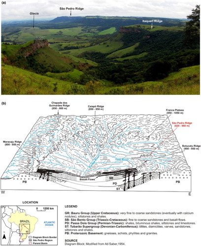
The São Pedro region in southeastern Brazil lies close to the northeastern border of the Paraná Basin, which is a large geotectonic unit of the South America Plate (). It is characterised as a region of cuesta landforms formed at the transition between plateau zones, supported by Eo-Cretaceous basalt flows and large depressions sculpted on Palaeozoic and Mesozoic sedimentary rocks. The landforms of the São Pedro region have been studied since the 1930s and the research has primarily emphasised the erosional factors related to their genesis (e.g. CitationAb’Saber, 1965, Citation1969; CitationQueiroz Neto & Journaux, 1978). However, some studies have highlighted the influence of tectonic activity on the formation of these landforms (e.g. CitationPenteado, 1976; CitationPinheiro, 2014; CitationPinheiro & Queiroz Neto, 2014, Citation2015; CitationSantos & Ladeira, 2006).
Figure 1. (a) Cuesta landforms in the São Pedro region. In the background, São Pedro ridge and a glacis. Source: Pinheiro (Citation2014). (b) Diagram of the Upper Paraná Basin.
Currently, the most important research regarding the São Pedro region is the Geomorphological Map of São Pedro (CitationQueiroz Neto & Journaux, 1978). Supported by the principles of the Recherche Coopérative sur Programme 77 (CitationTricart, 1972), this map was presented at the French–Brazilian Interdisciplinary Conference on the Study and Cartography of Superficial Formations and its Applications in Tropical Regions, which was held in Brazil in 1978. According to this map and its Appendix (CitationDias Ferreira, Coutard, Pellerin, & Queiroz Neto, 1978), the relief of the mapped area is considered primarily a consequence of palaeoenvironmental changes related to four main Quaternary glaciations. Supported by the classical geomorphological models of CitationKing (1956) and CitationBigarella, Mousinho, and Silva (1965), these glaciations are thought to have caused deep weathering and fluvial incisions during wet periods and mechanical erosion with planing during the dry periods. This interpretation is evident in the legend of the map, which divides the landforms and deposits into different climatic domains (i.e. Wet Tropical and Dry Tropical), following the principles of the legend established by CitationTricart (1972).
Since the production of the Geomorphological Map of São Pedro, many studies undertaken subsequently in this region have raised doubt over some of the earlier interpretations expressed on the map. In this context, the aim of this research was to present new information about the development of landforms in the São Pedro region in an updated geomorphological map (Main Map) that synthesises new data and interpretations. Furthermore, improvements and updates to the original French legend used on the previous map are recommended.
2. Geological–geomorphological context of the study area
2.1. The Paraná basin and the regional context of the study area
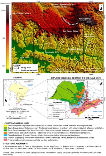
The São Pedro region lies within the Paraná Basin in southeastern Brazil. It comprises a large sedimentation zone with stratigraphic records extending from the Upper Ordovician to the Upper Cretaceous (CitationMilani, 1997) and it is considered a typical intracratonic basin (CitationMilani & Ramos, 1998). Its stratigraphic column presents more than 5000 m of sediments that have been deposited in diverse environments, together with basalt flows and intrusions of acid and basic rocks ().
The study area is in the northeastern region of the Paraná Basin in São Paulo State (southeastern Brazil). It is crossed by large structural alignments () comprising fault zones and long lineament domains. These alignments have influenced the distribution of sedimentation within the basin (i.e. the Tietê Alignment, defined by CitationCoimbra, Brandt Neto, and Petri (1977) and CitationRiccomini (1995)) and they have been fundamental in controlling the development of regional landforms, as in the formation of the two most important morphosculptural units (): the Western Plateau and the Paulista Peripheral Depression (CitationRoss & Moroz, 1997). These alignments control the direction of the principal rivers, which, constrained by the arcing Paraná Basin border, have eroded the periphery of this large basin since the Palaeogene and given rise to the Paulista Peripheral Depression (CitationAb’Saber, 1965, Citation1969; CitationPinheiro, 2014). In the transition between this large basin and the lower depression zone in the upper west of the region, the Western Plateau has been formed from cuesta landforms and it is recognised as one of the best examples ( and ) of this structural relief in the Paraná Basin.
Figure 2. Geological and geomorphological characteristics of the study area.
2.2. The São Pedro region
The long structural alignments that lie close to the São Pedro region () have played an important role in the formation of the main geomorphological components of the northeastern region of the Paraná Basin, as noted above. The most important structure crossing the study area is the Santa Maria–Cabreúva Lineament (NW–SE). This is a long alignment of streams and landforms (CitationPires Neto, 1996), which, in the São Pedro region, has presented normal faults as a consequence of local distension related to sinistral strike-slip faults reactivated in the current tectonic regime (CitationPinheiro, 2014; CitationPinheiro & Queiroz Neto, 2015). According to these authors, these main structures and the secondary lineament domains (NE–SW, E–W, and N–S), as well as the movement of tectonic blocks (uplifting and downlifting), have controlled the landform dissection of the area and its geomorphological development as a whole.
The São Pedro region can be divided into two main parts: the São Pedro ridge, which marks the border of the Western Plateau and the glacis or pediments, which is the piedmont zone extending into the Paulista Peripheral Depression ( and ). The São Pedro ridge has developed on the Lower Cretaceous basalts (CitationRenne et al., 1992; CitationThiede & Vasconcelos, 2010) of the Serra Geral Fm., Lower Cretaceous fine aeolian sandstones (CitationScherer, 1998) of the Botucatu Fm., and sandy to rudaceous deposits of alluvial fans cemented by silica and iron oxides (Itaqueri Formation; CitationAlmeida & Barbosa, 1953; CitationRiccomini, 1997), whose depositional age remains unknown. The glacis is formed by Triassic fine to conglomeratic sandstone of the Pirambóia Fm. capped by Upper Pleistocene colluvial sandy cover (CitationPinheiro & Queiroz Neto, 2015). The average elevation of the ridge top is about 900 m and that of the glacis is around 620 m. These topographic levels are, respectively, the record of the Cristas Médias Planing Surface (Palaeogene) and the Neogênica Planing Surface (Neogene), as defined by CitationDe Martonne (1940).
The origin of the ridge is related to the circumdenudation process of the Paraná Basin margins, caused by large rivers entrenched in old structures (CitationAb’Saber, 1965, Citation1969; CitationPinheiro, 2014). According to CitationPinheiro and Queiroz Neto (2014), a proto-escarpment would have been formed between the Palaeocene and Eocene at the current location of the Piracicaba River valley () and its geomorphological configuration would have been changed by erosion and neotectonic activity, leading to the formation of the São Pedro ridge and its glacis.
2.3. Main processes and associated landforms of the mapped area
The bottom of the São Pedro ridge presents a gentle landscape comprising lower hills and knolls sculpted on basalts (Serra Geral Fm.) and fine to coarse sandstones (Itaqueri Fm.) by streams entrenched along structural lines (NW–SE, NE–SW, and E–W) as faults and large fractures. These rivers have promoted gentle convex-shaped watersheds and wide open valleys in most parts of this sector, with structural breaks (corniche) occurring in the amphitheatres and knickpoints of the main rivers, which are generally associated with variations of the basalt flows. Another typical landform of the São Pedro ridge top are the ruiniform reliefs ((a)) sculpted on ferruginous and siliceous cuirasses (ferricretes and silcretes) of the Itaqueri Fm., which are dominant in the east of the region and maintain their higher topographic levels.
Figure 3. (a) Ruiniform landforms of the São Pedro ridge bottom. (b) Sandy coverture on glacis. (c) Pedra de Torrinha isolated hill. (d) Basalt step in the escarpment. (e) Stone lines in the sandy coverture of the glacis. (f) Slope break in convex-shaped watershed of the glacis. (g) Coarse fluvial sediments of higher fluvial terrace (T1) of the Piracicaba river. (h) Sandy fluvial bar in Piracicaba river tributary. Source: Authors of the photos: Marcos Roberto Pinheiro and Marisa de Souto Matos Fierz.
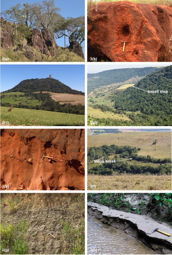
The top of the São Pedro ridge presents a sandy coverture on convex-shaped watersheds ((b)). Its origin remains under debate but current studies (CitationPinheiro, 2014; CitationPinheiro & Queiroz Neto, 2015; CitationPinheiro, Michelon, & Manfredini, 2016) have suggested this coverture is allochthonous and that it was deposited in the Upper Pleistocene under a dry climate. The characteristics of the sediments (sub-rounded to rounded grains with frosted appearance and impact marks) and the absolute age of the coarse levels (stone lines), 17,150 (±2700; point 6) and 12,000 (±1500; point 7) yr BP, are coincident with the Last Glacial Maximum and the Pleistocene–Holocene transition, respectively.
In contrast with the gentle landform at the bottom of the São Pedro ridge, the escarpment presents steeper slopes and higher topographic levels of about 250 m. It is very irregular because of fluvial erosion caused by the right-margin tributaries of the Piracicaba River, especially under Quaternary wet climates. These streams have formed large amphitheatres that are separated by promontories and crests, which, in some cases, have become cut off from the escarpment, giving rise to isolated hills ((c)) supported by more resistant rocks such as basalt or diabase. Into the amphitheatres, the slopes are very steep because of the high frequency of rock falls (gravitational process) and dejection cones, whereas in the front of other parts of the escarpment, the slopes are less steep and present many irregularities and breaks due to lithological variation. In some cases, the differential erosion has formed large steps ((d)), generally supported by basalt or silicified sandstones.
The rapid retreat of the escarpment of the São Pedro ridge, mainly under the dry climates of the Quaternary and Upper Tertiary, enlarged the glacis area (CitationPinheiro & Queiroz Neto, 2014), which initially would have been a gently sloping plain covered by a thin and sandy-to-coarse sedimentary layer. The origin of this sedimentary cover remains unknown. However, considering examples of pediments recorded on the Colorado Plateau – USA (CitationSchmidt, 1989, Citation1996) and in the Ebro Depression – Spain (CitationGutiérrez, Sancho, & Arauzo, 1998), both of which are presently under a semiarid climate, it could be a vestige of escarpment talus deposits or traces of mechanical erosion of the subjacent sandstone (Pirambóia Fm.). This interpretation is in agreement with the absolute dating data presented by CitationPinheiro (2014) and CitationPinheiro and Queiroz Neto (2015). According to these authors, the ages of the coarse levels (stone lines; (e)) of the sedimentary cover on the glacis, which range from 106,900 (±20,250; point 3) to 65,580 (±7650; point 3) yr BP, are coincident with the Würm dry periods.
During the following wet periods, stream competency recovered and the glacis suffered intense fluvial dissection by the main Piracicaba River tributaries, which initially gave rise to V-shaped valleys that evolved into long and narrow floodplains. This fluvial action also promoted convex-shaped watersheds and the formation of structural breaks ((f)) at the most resistant layers of the Pirambóia sandstones.
Under these wetter climatic conditions, geochemical processes were intensified and thus, the pedological cover thickened, pseudo-karstic landforms (closed depressions) formed because of quartz dissolution (geochemical erosion), and dejection cones, talus deposits, and the detrital cover of the glacis were quickly weathered. The thickening of the weathered mantle was not intense in the SE of the region (degraded glacis) as this sector has been dissected much more (), a consequence of the uplifting of the region in relation to the other parts of the glacis, as demonstrated by CitationPinheiro (2014) and CitationPinheiro and Queiroz Neto (2015).
These climatic oscillations also provide the basis for understanding the origin of the fluvial terraces of the main rivers. Intense mechanical erosion in the glacis watersheds under dry periods would have eroded the pedological cover formed in the previous wet period, increasing fluvial sedimentation and raising the base levels of the streams (CitationPinheiro, 2014). The following wetter climate would have promoted increased stream competence and therefore, these alluvial deposits would have been carved by the Piracicaba and Tietê rivers, forming the current different levels of the fluvial terraces ((g)).
This hypothesis was proposed by CitationQueiroz Neto and Journaux (1978) and CitationCoutard, Dias Ferreira, Pellerin, and Queiróz Neto (1978), and is supported by the ages of the coarse sediments of the higher and older Piracicaba terrace level (T1), that is, about 39,300 (±4100; point 2) and 28,930 (±2720; point 5) yr BP (CitationPinheiro, 2014; CitationPinheiro & Queiroz Neto, 2015), which are coincident with the driest periods of the Upper Pleistocene (e.g. CitationBehling & Lichte, 1997; CitationBehling, Lichte, & Miklos, 1998; CitationLedru et al., 1996) in southeastern Brazil. On the other hand, the origin of the lower and younger Piracicaba fluvial terrace (T3) could be related to the climatic oscillations of the Upper Holocene (Little Ice Age?), considering the younger age of the sediments, about 750 (±150; point 1) yr BP; however, this hypothesis needs additional data to be validated. These data and interpretations are in agreement with recent research regarding the fluvial terraces in other sectors of the Piracicaba basin (CitationDias & Perez Filho, 2015; CitationSouza, 2016) and other principal rivers of the Paulista Peripheral Depression (CitationStorani & Perez Filho, 2015).
Finally, it is important to highlight the high frequency of ravines and gullies in the São Pedro region, especially in the glacis and at the watershed between the Piracicaba and Tietê rivers. Some authors have suggested that these gullies and ravines could be related to neotectonic activity (CitationHasui, Facincani, Santos, & Jiménes Rueda, 1995). However, the origin of these erosional forms is probably related to hydrological imbalance within the pedological coverture, intensified by the increase of runoff due to the increase in deforestation, grazing, and agriculture, since the nineteenth century (CitationPinheiro, 2014). Watershed erosion has caused intense fluvial sedimentation, which is evident in the tributaries of the Piracicaba River, considering the large numbers of sandy alluvial fans and bars ((h)) at the mouths of the most eroded fluvial basins.
3. Methods
The map was produced from photogrammetric restitution of panchromatic aerial photographs (IA/SMA, 1:25,000 scale, year 1962), using pocket and mirror stereoscopes. The restitution was performed using Ultraphan film lain over the photographs, which were fixed in groups of three sequential images: one central and two lateral photographs. Moreover, the central and homologue points and the flight strip were marked, as per the method of CitationMarchetti and Garcia (1977).
The overlays were then scanned using a professional A3 scanner, registered and georeferenced using Esri ArcGIS (version 10) with digital base charts as reference (topographic charts 1:50,000 from IBGE – Brazilian Institute of Geography and Statistic), and available as separate vector layers. Finally, the mapping information was checked by field surveys and submitted to the process of cartographic generalisation for integration into the final version of the map at 1:50,000 scale.
In order to determine the chronology of the fluvial deposits and the watershed sedimentary cover, the absolute dating of these sediments was performed using optically stimulated luminescence (OSL). The samples were collected in stainless steel pipes (5.08 × 35 cm; Ø × length) that were introduced into the deposits with the aid of a rubber hammer. The pipes were closed with opaque PVC caps, wrapped in black plastic bags, and sent to Datação, Comércio e Prestação de Serviços Ltda Corporation, which performed the analyses using the single-aliquot regenerative dose protocol. These results were published in CitationPinheiro (2014) and CitationPinheiro and Queiroz Neto (2015) and reproduced in the previous chapter.
The map legend is based upon the Geomorphological Map of São Pedro (CitationQueiroz Neto & Journaux, 1978) and is organised into three sections as proposed by the R.C.P. 77 concerning detailed geomorphological cartography:
The first level corresponds to the hydrography (blue colour) that represents the fluvial system organization and distribution;
The second level is the structural and lithological context, which exposes the lithostratigraphic units and their constitution (each unit has a default colour), as well as the tectonic structures (black colour);
The third level corresponds to the morphogenetic context that represents not only the shape of the landforms but also an interpretation of the formational processes. The structural forms (brown colour) are derived from tectonic and lithological elements. The forms associated with fluvial action (green colour) include aggradation (floodplain, fluvial terraces, backswamps, dejection cones, and point bars) and degradation features (concave and convex breaks, terrace scarps, and shapes of valleys), in addition to the chronology of the terraces of the Tietê and Piracicaba rivers. The pseudo-karstic landforms (closed depressions) originated from geochemical erosion, mainly quartz dissolution. Landforms related to anthropic action are the linear erosional forms (black colour) generated from surficial (ravines) or underground (gullies) concentrated flows of water and hydrological imbalances within the soil. The landslide scars (black colour) are rocky walls at the escarpment front, which are related to gravity, constituting a recent record of block falls and slides. Finally, the polygenic forms (orange colour) correspond to landform patterns whose actual complex morphology (glacis and hillocks supported by cuirasses) is related to different morphogenetic domains: mechanical erosion was predominant under Quaternary stages with a semiarid climate, whilst deep weathering was more important during wet phases.
4. Advances of the current map and of its geomorphological information in relation to the former map
The present geomorphological map (Main Map) includes the following improvements in relation to the former map made in 1978: (1) changes and updates to the legend; (2) enlargement of the area mapped; (3) new chronological information regarding fluvial terraces and colluvial covers; (4) inclusion of tectonic structures; and (5) geomorphological mapping using GIS technology. These improvements are detailed in the following:
Some content in the legend was changed to incorporate current tendencies in geomorphological mapping (i.e. CitationMartins, Fernandez, Isidoro, Jordán, & Zavala, 2016; CitationVillela, Ross, & Manfredini, 2013; CitationViveen, Schoorl, Veldkamp, Balen, & Van Vidal-Romani, 2013) and new information regarding the study area. The main changes comprised the following: (1) inclusion of new morphological elements such as tectonic structures (faults, large fractures, and lineaments), pseudo-karstic forms (closed depressions), and gravitational slope forms (landslide scars); (2) subdivision of the ‘Forms Related to Fluvial Action’ item into ‘Denudational Forms’ and ‘Aggradational Forms’ (this division was performed only to this item because the other items presented only Denudational Forms); (3) the ‘Structural Forms’ were separated from the ‘Lithology and Structure’ item to improve the relation among landforms and associated processes in the legend; (4) the ‘Stratigraphy of Colluviums’ was included in the ‘Lithology and Structure’ item because this is considered the item most appropriate for information about materials (rocks and deposits).
In addition to the inclusion of these new items, a category for ‘Polygenic Forms’ was also created and the ‘Morphogenetic Domains’ category was suppressed. This was because the landforms of the area are products of the different climates of the Quaternary period and the Cenozoic Era as a whole and therefore, it is impracticable to associate each landform to a specific palaeoenvironment.
In relation to the size of the area, the new map covers around 924 km2, which is more than double that of the former map. Thus, the new map not only enhances the details concerning the previous study area, but also provides new information about nearby regions for which geomorphological data were previously unclear.
The sandy coverture is colluvial in most of the glacis (i.e. in the preserved area where fluvial dissection was not so intense) and the São Pedro ridge bottom, and it was deposited in the dry periods of the Upper Pleistocene, as explained in Section 2.3. This hypothesis had been already proposed based on the previous map of CitationQueiroz Neto and Journaux (1978), but the new map establishes updated limits and accurate ages for this coverture, considering the absolute dating data mentioned in Section 2.3. The new map also includes the most recent information regarding the relation between morphogenesis and pedogenesis (CitationDias Ferreira, 1997; CitationFurquim, 2002; CitationFurquim, Coltrinari, Dias Ferreira, Castro, & Pugliese, 2013), considering that the sandy cover in some parts of the glacis is autochthonous (i.e. in the most dissected area).
In the map of 1978, four levels of fluvial terraces of the Piracicaba River were mapped. These fluvial features were interpreted as a consequence of the large Quaternary glaciations: Würm, Riss, Mindel, and a fourth unspecified glacial period in the Lower Quaternary (CitationCoutard et al., 1978; CitationQueiroz Neto & Journaux, 1978). On the other hand, CitationPires Neto (1996) suggested these fluvial terraces could be related to disturbances in the Piracicaba base level due to the reactivation of the tectonic structures that cross the river. CitationPinheiro (2014) and CitationPinheiro and Queiroz Neto (2015) rebutted this hypothesis and considered that the terraces were probably related to environmental changes, as previously proposed by the authors mentioned.
Despite the probable palaeoclimatic origin of the terraces, these latest studies have demonstrated that the terraces are younger than originally supposed by the authors of the earlier map. According to the current research, the fluvial terraces were formed in the Upper Pleistocene by young and short climate cycles (glacial and interglacial oscillations) instead of during long glacial periods. The present map includes these new data but suppresses the highest fluvial terrace mapped in 1978 as it has been destroyed by anthropic activity.
CitationBjornberg (1969) and the geomorphological map of 1978 traced several geologic/tectonic structures in the São Pedro region, despite clear evidence of structural influence on these landforms. To overcome this gap in the understanding concerning the relations between tectonics and landforms within the area, CitationPinheiro (2014) and CitationPinheiro and Queiroz Neto (2015) performed a morphotectonic study of the São Pedro ridge and the Lower Piracicaba River region. They demonstrated that there are many tectonic structures within the region and that they were active in the neotectonic period (the tectonic regime initiated in the Neogene). These researchers have also shown that the structures have not only influenced the formation of landforms, but they have also controlled the uplifting and downlifting of tectonic blocks, causing the dissection of the degraded glacis and an increase in fluvial sedimentation in the subsidence areas, respectively. All the structures were included on the new map.
The original map of 1978 was drawn based on several aerial photographs and the amalgamation of information was accomplished using manual techniques. The new map was also based on aerial photographs; however, it was produced using GIS technology, where the overlay geometries were corrected using modern topographic base maps as reference, so improving the mapping accuracy. The GIS environment also allowed the incorporation of information from other thematic maps and digital elevation models (DEMs). Finally, the digital environment permitted the inclusion of lithostratigraphic units on the map, the representation of which was limited in the classical map of 1978; thereby, improving the understanding of the relationships between materials and landforms.
5. Conclusions
The origin of the landforms of the São Pedro region is related to the genesis of large geomorphological compartments, that is, the Paulista Peripheral Depression and the Western Plateau, during the Cenozoic. In the transition between these units, a typical cuesta landform was formed because of the tectonics, differential erosion, and palaeoenvironmental changes. The tectonic structures (NW–SE, NE–SW, E–W, and N–S) have controlled the orientation of the drainage network, which dissects the region through the Piracicaba River and its tributaries, especially during the wetter periods. Under dry climates, the planing process was predominant, causing a faster retreat of the escarpment of the São Pedro ridge and giving rise to a glacis and its colluvial sandy cover. This escarpment and the glacis were dissected during the following wet periods, forming the upper Quaternary main fluvial terraced levels of the Piracicaba and Tietê rivers. This general geomorphological development was disturbed by the reactivation of old structures in the neotectonic period, because the uplifting of tectonic blocks intensified the dissection of some regions, such as the degraded glacis.
The geomorphological map of the São Pedro ridge and the Lower Piracicaba River region represents an advance over the original Geomorphological Map of São Pedro constructed in 1978, not only because it covers a larger area and improves the organisation of the legend, but because it also includes current understanding of the pedogenesis–morphogenesis relation and tectonics. Furthermore, it also establishes a new proposal for the chronology of the fluvial terraces and deposits that overlay the old planing surfaces.
Software
The maps were produced using Esri ArcGIS 10 and Global Mapper 10.
Geomorphology of the São Pedro Ridge and Lower Piracicaba River Region, southeastern Brazil.zip
Download Zip (119.6 MB)Disclosure statement
No potential conflict of interest was reported by the authors.
ORCiD
Marcos Roberto Pinheiro http://orcid.org/0000-0002-0864-2441
Related Research Data
References
- Ab'Saber, A. N. (1954). A geomorfologia do Estado de São Paulo [Geomorphology of the São Paulo State]. Aspectos geográficos da Terra Bandeirantes, Rio de Janeiro, IBGE, pp. 1–97.
- Ab’Saber, A. N. (1965). Da participação das depressões periféricas e superfícies aplainadas na compartimentação do Planalto Brasileiro (Unpublished Free-docent Thesis). Faculty of Philosophy, Languages and Literature, and Human Sciences. University of São Paulo, Brazil.
- Ab’saber, A. N. (1969). A Depressão Periférica Paulista: um setor das áreas de circundenudação pós-cretácica da bacia do Paraná [Paulista Peripheral Depression: A sector of the Post-Cretaceous circumdenudation regions of the Paraná Basin]. Boletim do Instituto Geografia/USP, 15, 1–15.
- Almeida, F. F. M., & Barbosa, O. (1953). Geologia das quadrículas de Piracicaba e Rio Claro – Estado de São Paulo [Geology of the Piracicaba and Rio Claro Sheets – State of São Paulo]. Boletim da Divisão de Geologia e Mineralogia, 143, 1–96.
- Almeida, F. F. M., Hasui, Y., Ponçano, W. L., Dantas, A. S. L., Carneiro, C. D. R., Melo, M. S., & Bistrichi, C. A. (1981). Mapa Geológico do Estado de São Paulo [Map - 1:500,000 scale]. 2 volumes. São Paulo: Instituto de Pesquisas Tecnológicas.
- Behling, H., & Lichte, M. (1997). Evidence of dry and cold climatic conditions at glacial times in tropical Southeastern Brazil. Quaternary Research, 48(3), 348–358. doi:10.1006/qres.1997.1932
- Behling, H., Lichte, M., & Miklos, A. W. (1998). Evidence of a forest free landscape under dry and cold climatic conditions during the last glacial maximum in the Botucatu region (São Paulo State), southeast Brazil. Quaternary of South America and Antarctic Peninsula, 11, 9–110.
- Bigarella, J. J., Mousinho, M. R., & Silva, J. X. (1965). Pediplanos, pedimentos e seus depósitos correlativos no Brasil [Pediplain, pediments and correlative deposits in Brazil]. Boletim Paranaense de Geografia, Curitiba, SP, 16 and 17, 117–154.
- Bjornberg, A. J. S. (1969). Contribuição ao estudo do cenozóico paulista: tectônica e sedimentologia (Unpublished titular-professor thesis). São Carlos School of Engineering, University of São Paulo, Brazil.
- Coimbra, A. M., Brandt Neto, M., & Petri, S. (1977). O alinhamento estrutural do Tietê [The structural alignment of the Tietê river]. Atas do I Simpósio de Geologia Regional, Sociedade Brasileira de Geologia, Simpósio de Geologia Regional, I, São Paulo, pp. 145–152.
- Coutard, J. P., Dias Ferreira, R. P., Pellerin, J., & Queiróz Neto, J. P. (1978). Excursão à região da Serra de São Pedro e Vale do Piracicaba [Field trip to the São Pedro ridge and valley of the Piracicaba river region]. Colóquio Interdisciplinar Franco-Brasileiro. Estudo e Cartografação de Formações Superficiais e suas Aplicações em Regiões Tropicais. Guia de Excursões. v.2, São Paulo, pp. 45–74.
- De Martonne, E. (1940). Problemes morphologiques du Bresil tropical atlantique [Morphological problems of Tropical Atlantic Brazil]. Annales de Geographie, 49, 1–27 and 106–129. doi: 10.3406/geo.1940.11479
- Dias, R. L., & Perez Filho, A. (2015). Geocronologia de terraços fluviais na bacia hidrográfica do rio Corumbataí-SP a partir de Luminescência Opticamente Estimulada (LOE) [Geochronology of fluvial terraces in Corumbataí-SP river basin using the method Optically Stimulated Luminescence (OSL)]. Revista Brasileira de Geomorfologia, 16, 341–349. http://dx.doi.org/10.20502/rbg.v16i2.644
- Dias Ferreira, R. P. (1997). Solos e Morfogênese em São Pedro (Unpublished Ph.D. Thesis). Department of Geography. Faculty of Philosophy, Languages and Literature, and Human Sciences. University of São Paulo - Brazil.
- Dias Ferreira, R. P., Coutard, J. P., Pellerin, J. Q., & Queiroz Neto, J. P. (1978). Carta Geomorfológica de São Pedro, SP - Memorial Explicativo [Geomorphological chart of São Pedro, SP – Explanatory Text]. Sedimentologia e Pedologia (IGEOG – USP), 12, 1–33.
- Furquim, S. A. C. (2002). Interações entre modelado e solo no transecto espraiado, São Pedro (Unpublished Msc. Dissertation). Department of Geography. Faculty of Philosophy, Languages and Literature, and Human Sciences. University of São Paulo - Brazil.
- Furquim, S. A. C., Coltrinari, L., Dias Ferreira, R. P., Castro, S. S., & Pugliese, G. R. (2013). Lamellae formation processes in tropical soils in southeastern Brazil. Catena (Cremlingen), 107, 15–25. doi:10.1016/j.catena.2013.03.005
- Gutiérrez, M., Sancho, C., & Arauzo, T. (1998). Scarp retreat in semiarid environments from talus flatirons (Ebro Basin, NE Spain). Geomorphology, 25, 111–121. doi:10.1016/S0169-555X(98)00034-8
- Hasui, Y., Facincani, E. M., Santos, M., & Jiménes Rueda, J. R. A. (1995). Aspectos estruturais e neotectônicos na formação de boçorocas na região de São Pedro, SP [Structural and neotectonic aspects on the formation of gullies in the São Pedro region, SP]. Geociências, São Paulo, 14(2), 59–76.
- King, L. C. (1956). A Geomorfologia do Brasil Oriental [Geomorphology of Western Brazil]. Revista Brasileira de Geografia, Rio de Janeiro, 18(2), 147–265.
- Ledru, M. P., Braga, P. I. S., Soubies, F., Fournier, M., Martin, L., Suguio, K., & Turcq, B. (1996). The last 50.000 years in the Neotropics (Southern Brazil): Evolution of vegetation and climate. Palaeogeography, Palaeoclimatology, Palaeoecology, 123, 239–257. doi:10.1016/0031-0182(96)00105-8
- Marchetti, D. A. B., & Garcia, G. J. (1977). Princípios de fotogrametria e fotointerpretação [ Principles of photogrammetry and photointerpretation]. São Paulo: Nobel.
- Martins, F. M. G., Fernandez, H. M., Isidoro, J. M. G. P., Jordán, A., & Zavala, L. (2016). Classification of landforms in Southern Portugal (Ria Formosa Basin). Journal of Maps, 12(3), 422–430. doi:10.1080/17445647.2015.1035346
- Milani, E. J. (1997). Evolução tectono-estratigráfica da Bacia do Paraná e seu relacionamento com a geodinâmica fanerozoica do Gondwana Sul-Ocidental. (Unpublished Ph.D. Thesis). Institute of Geosciences, Federal University of Rio Grande do Sul, Brazil.
- Milani, E. J., & Ramos, V. (1998). Orogenias paleozóicas no domínio ocidental do Gondwana e os ciclos de subsidência da Bacia do Paraná [Palaeozoic orogenies in the western region of Gondwana and subsidence cycles of the Paraná Basin]. Revista Brasileira de Geociências, 28(4), 473–484.
- Penteado, M. M. (1976). Geomorfologia do setor centro-ocidental da Depressão Periférica Paulista [Geomorphology of the western-center region of the Paulista Peripheral Depression]. IGEOG/USP, 22, 1–86.
- Pinheiro, M. R. (2014). Estudo morfotectônico da região da Serra de São Pedro e do Baixo Piracicaba/SP (Unpublished Ph.D. Thesis). Department of Geography. Faculty of Philosophy, Languages and Literature, and Human Sciences. University of São Paulo - Brazil. doi:10.11606/T.8.2014.tde-11052015-170604
- Pinheiro, M. R., Michelon, C. R., & Manfredini, S. (2016). Gênese dos depósitos neocenozóicos do reverso da Serra de São Pedro e evolução da superfície das Cristas Médias – sudeste do Brasil [Origin of the upper Cenozoic deposits of the backslope of the São Pedro ridge and Cristas Médias planing surface development - southeastern Brazil]. Revista Brasileira de Geomorfologia. Manuscript accepted for publication.
- Pinheiro, M. R., & Queiroz Neto, J. P. (2014). Reflexões sobre a gênese da Serra Geral e da Depressão Periférica Paulista: o exemplo da região da Serra de São Pedro e do Baixo Piracicaba, SP [Reflections on the genesis of the Serra Geral and the Paulista Peripheral Depression: The example of the region of São Pedro and the lower Piracicaba river, SP]. Revista do Instituto Geológico, São Paulo, 35 (1), 47–59. doi:10.5935/0100-929X.20140004
- Pinheiro, M. R., & Queiroz Neto, J. P. (2015). Neotectônica e evolução do relevo da região da Serra de São Pedro e do Baixo Piracicaba – Sudeste do Brasil [Neotectonics and landform development of the São Pedro ridge and lower Piracicaba river region/Southeastern Brazil]. Revista Brasileira de Geomorfologia, 16(4), 593–613. doi:10.20502/rbg.v16i4.668
- Pires Neto, A. G. (1996). Estudo Morfotectônico das Bacias Hidrográficas dos Rios Piracicaba, Capivari e Jundiaí e Áreas Adjacentes no Planalto Atlântico e Depressão Periférica (Unpublished Postdoc Report). Institute of Geosciences and Exact Sciences of the São Paulo State University - Brazil. 70p.
- Queiroz Neto, J. P., & Journaux, A. (1978). Carta geomorfológica de São Pedro, SP. [Map - 1:50,000 scale]. Laboratório de Sedimentologia e Pedologia do Departamento de Geografia-FFLCH-USP-Brazil and Centre de Géomorphologie du CNRS-Caen-France. São Paulo: Terrafoto and Institute of Geography of the USP.
- Renne, P. R., Ernesto, M., Pacca, I. G., Coe, R. S., Glen, J. M., Prévot, M., & Perrin, M. (1992). The age of Paraná flood volcanism, rifting of Gondwanaland, and the Jurassic-Cretaceous boundary. Science, 258, 975–979. doi:10.1126/science.258.5084.975
- Riccomini, C. (1995). Tectonismo Gerador e Deformador dos Depósitos Sedimentares Pós-Gondvânicos da Porção Centro-Oriental do Estado de São Paulo e Áreas Vizinhas (Unpublished Free-docent Thesis). Institute of Geosciences. University of São Paulo – Brazil.
- Riccomini, C. (1997). Considerações sobre a posição estratigráfica e tectonismo deformador da formação Itaqueri na porção centro-leste do Estado de São Paulo [Considerations regarding the stratigraphic position and deforming tectonics of the Itaqueri Formation in the western-center region of the State of São Paulo]. Revista do Instituto Geológico, 18, 41–48. doi:10.5935/0100-929X.19970003
- Ross, J. L. S., & Moroz, I. C. (1997). Mapa Geomorfológico do Estado de São Paulo [Map: 1:500,000 scale]. São Paulo: Department of Geography-FFLCH-USP and IPT-FAPESP.
- Santos, M., & Ladeira, F. S. B. (2006). Tectonismo em perfis de alteração na Serra da Itaqueri (SP): análise através de indicadores cinemáticos de falhas [Tectonics on weathered profiles in the Itaqueri Ridge (SP): Analysis through kinematics indicators of faults]. São Paulo, UNESP, Geociências, 25(1), 135–149.
- Scherer, C. M. S. (1998). Análise Estratigráfica e Litológica da Formação Botucatu (Eocretáceo da Bacia do Paraná) no Rio Grande do Sul (Unpublished Ph.D. Thesis). Institute of Geosciences, Federal University of Rio Grande do Sul, Brazil.
- Schmidt, K.-H. (1989). The significance of scarp retreat for Cenozoic landform evolution on the Colorado Plateau, USA. Earth Surface Processes and Landforms, 14, 93–105. doi:10.1002/esp.3290140202
- Schmidt, K.-H. (1996). Talus and pediment flatirons: Indicators of climatic change on scarp slopes on the Colorado Plateau, USA. Zeitschrift für Geomorphologie, 103( Suppl. Bd), 135–158.
- Souza, A. O. (2016). Dinâmica geomorfológica e geocronologia das coberturas superficiais do Ribeirão Araquá, município de São Pedro e Charqueada-SP. (Unpublished Msc. Dissertation). Institute of Geosciences. University of Campinas, Brazil.
- Storani, D. L., & Perez Filho, A. (2015). Novas informações sobre geocronologia em níveis de baixo terraço fluvial do Rio Mogi Guaçu, SP, Brasil [New information on Geochronology in levels of the low river terrace of Rio Mogi Guaçu in São Paulo, Brazil]. Revista Brasileira de Geomorfologia, 16, 191–199. doi:10.20502/rbg.v16i2.656
- Thiede, D. S., & Vasconcelos, P. M. (2010). Paraná flood basalts: Rapid extrusion hypothesis confirmed by new 40Ar/39Ar results. Geology, 38(8), 747–750. doi:10.1130/G30919.1
- Tricart, J. (1972). Normes pour l’établissement de La carte géomorphologique détailée de la France (1/20.000, 1/25.000, 1/50.000) [Rules for the establishment of the detailed geomorphological map of France (1/20,000, 1/25,000, 1/50,000)]. Mémoires et documents - Centre National de la Recherche Scientifique, 12, 37–105.
- Villela, F. N. J., Ross, J. L. S., & Manfredini, S. (2013). Relief-Rock-Soil relationship in the transition of Atlantic Plateau to Peripheral Depression, Sao Paulo, Brazil. Journal of Maps, 1, 1–10. doi:10.1080/17445647.2013.805170
- Viveen, W., Schoorl, J. M., Veldkamp, A., Balen, R. T., & Van Vidal-Romani, J. R. (2013). Fluvial terraces of the northwest Iberian lower Miño River. Journal of Maps, 9(4), 513–522. doi:10.1080/17445647.2013.821096