
ABSTRACT
In this paper, a 1:5000 map of the geomorphic consequences of the 14th–15th October 2015 flash flood is presented. The most severely affected area (about 13 km2) was located at the footslope of Mt. Camposauro (Southern Italy), between the municipalities of Solopaca and Paupisi. In this area high-intensity and very localized cloudbursts of short duration induced hillslope erosion and sediment delivery from the slopes to the Calore River, activating several alluvial fans. The rainstorm lasted 7 h with a maximum recorded rainfall peak of nearly 140 mm in 2 h. The event map resulting from a geological and geomorphological post-event field survey was supported by satellite images and unmanned aerial vehicle image interpretations, respectively taken one day and one week after the event. The flash flood resulted in no casualties but severely affected the local economy, mainly based on agriculture and wine production.
1. Introduction
Flash floods are sudden floods with high peak discharges produced by severe thunderstorms (CitationIAHS, 1974). Such floods are of limited areal extent and may occur in small catchments drained by torrential streams which feed alluvial fans. Despite being a serious natural hazard that affects countries throughout Europe (CitationGaume et al., 2009), flash floods remain a poorly studied natural phenomenon. They may display highly variable magnitudes due to the size of the basins, the concentration times and extent of possible channel filling. These phenomena induce highly erosive flows and impact forces due to the mix of water, soil, boulders, trees and debris, but they also have a very high rate of aggradation due to the deposition of large particles. During such events the basin/fan system may be subject to floods, hyperconcentrated flows and debris flow transport processes (CitationCosta, 1988; CitationNRC, 1996; CitationPierson, 2005; CitationVan Dine, 1985; CitationWilford, Sakals, Innes, Sidle, & Bergerud, 2004).
As these phenomena represent a serious threat for the many communities established on footslopes, several approaches for correctly assessing the risk have been proposed (CitationBerti & Simoni, 2007; CitationBertolo & Bottino, 2008; CitationHurlimann, Copons, & Altimir, 2006; CitationPelletier et al., 2005). At the same time, geological and geomorphological studies at larger scales (1:5000–1:1000) are of the utmost importance (CitationScorpio, Santangelo, & Santo, 2016).
Along the Southern Apennines, piedmont areas made up of coalescent alluvial fans are a common geomorphic unit. The alluvial fans are fed by drainage basins with high slopes, short response times and with a generally low runoff, occurring mainly during the most heavy rainfall periods. Recent studies have dealt with relationships between morphometric attributes of alluvial fans and those of the corresponding upslope basins, showing that this approach can be used effectively to classify alluvial fans with respect to the two dominant flooding mechanisms, namely debris flows and water floods (CitationSantangelo et al., 2012).
In most cases, such foothill areas are highly urbanized, and short but particularly intense rainfall events can produce flash floods with large debris loads, which may be extremely dangerous for the resident population and the urban settlements (Santangelo et al., Citation2011; CitationSanto, Di Crescenzo, Del Prete, & Di Iorio, 2012, Citation2015). Floods generally occur with return periods of several decades, reducing the awareness of local communities regarding current hazard conditions.
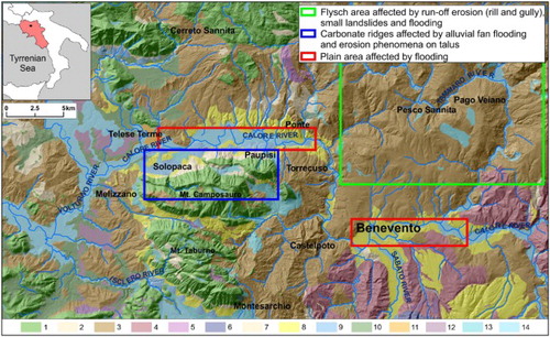
During the night of the 14th October 2015 a flash flood struck the central portion of Campania (Southern Italy), resulting in extensive damage to the towns and villages in an area nearly 200 km2 around Benevento. The event started around 21:00 and ended at about 04:00 the next day. The rainstorm particularly affected the Calore and Tammaro river valleys, where values about 150–250 mm in 7 h were recorded by the regional rain gauges, with a maximum of around 140 mm in 2 h (CitationDe Falco, Forte, Santangelo, & Santo, in press). The geomorphic consequences due to the heavy rainfall can be noted as follows ():
riverine flooding along the Calore river valley (in the surroundings of Ponte and Benevento)
alluvial fan flooding in the footslope area of Mt. Camposauro
widespread run-off erosion and landslides in the Tammaro river area
Figure 1. Area affected by geomorphic consequences due to the flash flood. Keys: 1) Limestones; 2) Clayey Flysch 3) Marly sandy Flysch; 4) Sandstones; 5) Flintstones; 6) Conglomerates; 7) Ancient Breccias; 8) Sandy Conglomerates; 9) Alluvial fans; 10) Tuff; 11) Travertines 12) Pyroclastic soils; 13) Detrital deposits; 14) Alluvial deposits.
This paper deals with the description of the flash flood event in the piedmont area of Mt. Camposauro, where the rainstorm produced widespread run-off landforms and the activation of several alluvial fans. This study aimed at collecting as much information as possible about stratigraphic and geomorphological indicators such as grain size and facies of deposits, flow paths, thickness of eroded and deposited materials and damage, prior to their removal. A post-flood study was therefore carried out both directly in the field and by means of a high resolution remote sensing survey. Indeed, according to CitationGaume and Borga (2008) a post-flood survey is one of the most efficient instruments to gain insights into such events, to collect data useful for depicting the flood scenario and provide suitable methods of analysis and technical solutions for flood prevention and control. Furthermore, they propose a two-step approach based on data collection and data analysis; the first phase is performed following four time-steps (just after the event, after a week, after a month, after a year), while for the second the rainfall data, discharge, runoff and accompanying processes are evaluated, together with a comparison with previous floods.
2. Study area
The area depicted on the Main Map is located on the northern slope of Mt. Camposauro (1390 m a.s.l.). It comprises a morphostructural carbonate ridge, a thick Pleistocene talus consisting of carbonate breccias and three generations of telescopically arranged alluvial fans. It is made of carbonate gravels with a pyroclastic matrix, which passes to Holocene fans and reaches the alluvial plain through five orders of river terraces of the Calore River (CitationCARG, 2010; CitationMagliulo & Cusano, 2016). The Calore River valley between the towns of Telese and Paupisi (see Map1) covers about 3050 km2 and is located within the axis of the Campanian sector of the Southern Apennines fold-and-thrust belt, which is the result of compressional tectonics mainly active during the Tertiary (CitationPatacca & Scandone, 2007).
3. Methods
The purpose of the study was to draw up a map, starting a week after the event, based on geological field surveys, remote sensing acquisition and a final interpretation phase, following guidelines proposed by CitationGaume and Borga (2008). The field work involved an eight-day campaign over an area of nearly 14.5 km2 aimed at documenting the triggered alluvial phenomena and major damage prior to removal of the debris. The overall reactivated fans were surveyed from the more distal lobes to the apexes, producing a digital photographic database of nearly 4000 pictures, simultaneously geolocated using Geosetter software and waypoints taken in the field using a global positioning system receiver.
Satellite orthoimages taken one day after the event by the EROS-B satellite were acquired for an area of nearly 20 km2 from the alluvial fan apexes to the Calore River in the neighborhood of the most damaged area around Paupisi. EROS-B acquires panchromatic images with a spatial resolution of 0.70 m in the spectral range of 0.5–0.9 μm.
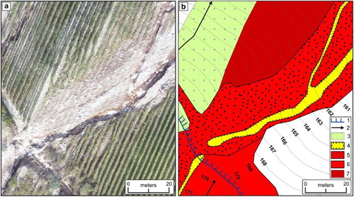
Satellite images were employed for interpreting and mapping some of the major landforms. In particular, it permitted the planning of a fixed-wing unmanned aerial vehicle (UAV) survey for the most severely affected area, on which photo-interpretation was carried out. The survey covered 13 km2, flying at 500 m using a calibrated 14 MP digital camera, producing 823 photographs for 7 overlapping flight lines. This produced a ground sampling distance (GSD) GSD of nearly 0.5 cm for the orthomosaic. Using the high resolution images the boundaries of several landforms were precisely mapped and the thickness of the deposits and their grain sizes estimated (). This was followed by field validation.
Figure 2. (a) High resolution UAV picture and (b) geomorphological interpretation of the landforms: (1) Manmadescarps with downslope erosion; (2) Rill and gully direction; (3) Rill and gully erosion – Land cover: slope plowing; (4) Area affected by downcutting and lateral erosion; (5) Coarse granular debris flow deposit; (6) Debris flow deposit; (7) Channel outflow with gravel deposition.
Furthermore, the orthoimage interpretation highlighted the most severely affected zones both for urban areas and farmland, comprising vineyards and olive groves. Conversely, the low resolution satellite images, focused on the uppermost portion of the basins not present in the UAV survey. All the acquired field data and photo-interpreted landforms were compared with the most recent images provided by Google Earth ©. They were mapped using Esri ArcGIS 10.2 on a 1:5000 topographic map derived from a LiDAR survey (1 m resolution) provided by the Italian Ministry of the Environment. The final layout of the map was edited using Corel Draw X7.
4. Map description
4.1. Map 1 – geomorphological map
The 1:35,000 map shows the geomorphological context of the study area. It represents two main bedrock units, which are the carbonate ridges (A) and the terrigenous flysch hilly area (B). On the right bank of the Calore river the old fluvial terraces (C) crop out, while on the left bank the footslope area (D) is represented, where the main urban area is located. Unit (E) is the alluvial plain of the Calore river. The map gives more details of the alluvial plain and footslope area which are the focus of the present study. The footslope area is formed of wide coalescent alluvial fans which are Middle to Late Pleistocene in age and are crossed by several tectonic fault scarps mainly N70 and N110 oriented. These scarps represent the surface expression of an active extensional system referred to as the Calore river fault (CitationDi Bucci, Massa, & Zuppetta, 2006). Another important fingerprint of this tectonic activity is the presence of several collapse sinkholes which are aligned to the main tectonic directions (CitationSanto, Ascione, Del Prete, Di Crescenzo, & Santangelo, 2011). Tectonics was also responsible for the disarticulation of the footslope area and for the growth of telescopic fan systems. The area is thus characterized by the presence of active and inactive/quiescent fans which can be accurately mapped. In particular, inactive/quiescent portions (lighter yellow), active lobes (dark yellow) and active fans (pink) were distinguished. They were mapped by locating the fan topographic and hydrographic apexes (or intersection points sensu CitationBlair & McPherson, 1994; CitationHooke, 1967). The height of the main channel banks was also evaluated, distinguishing between ‘deeply incised’ (fluvial scarp higher than 5 m) and ‘undissected’ (fluvial scarps lower than 5 m). In the floodplain unit, the inactive (old and recent terraces) and active portions (main channel, ordinary and extraordinary flood area) were distinguished.
This map aims primarily to represent the active and inactive portions of the footslope with respect to fluvial processes and permits rapid recognition of the areas susceptible to erosion, flooding and deposition.
The hydrographic basins feeding the fans are consecutively numbered from east to west and have a maximum elevation between 1000 and 1400 m a.s.l. Catchments 1–6 rest on flysch bedrock, 7 is both on flysch and limestone, while in catchments 8–43 only carbonate formations crop out.
Of all the catchments, three (6, 21 and 37) are characterized by a high hierarchical order, with deeply incised channel beds which flow into the Calore River. The catchments are between 4 and 8 km2, and have concentration times of around 15–30 minutes. The remaining 40 are smaller (less than 1 km2), with shallower channel beds and concentration times of less than 15 minutes (see tab. 1 on the map). They have an ephemeral regime and feed active alluvial fans which, in some cases, are covered by urban areas.
For catchments 6–21, which cover the area affected by the detailed post-flood survey, some morphometric parameters were calculated (see tab. on the map) for both the alluvial fans and the upslope basins. The catchment area is always smaller than 1 km2 and the mean inclinations of feeder channels range between 16° and 36°. Active fans generally have very small areas and the slope presents values ranging from 6° to 19°. Some of these morphometric attributes (feeder channel inclination and fan length) were assessed in order to classify the studied systems in terms of expected depositional processes, following CitationSantangelo et al. (2012), which proved to be debris flow dominated.
4.2. Map 2 – post-event geomorphological map
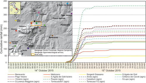
The flash which flood occurred on 14th–15th October 2015 mainly affected the eastern sector of the northern slope of Mt. Camposauro around the town of Paupisi. The rainfall distribution is shown in .
Figure 3. Raingauges and cumulative rainfall from 00:00 on 14th October (2015) to 24:00 on 15th October (2015); the bold lines are the data coming from the Centro Funzionale, Regione Campania; the dotted lines are those from the agrometeorological service.
Map 2 (1:5000) shows the extent of the geomorphic consequences for an area of 14 km2, which involved the activation of 21 basin/fan systems. The footslope area was involved with both run-off erosion and deposition processes. Only in a few cases did small flow-like landslides occur, mainly affecting the local roads. The alluvial plain was mainly affected by riverine flooding, which is not discussed in this paper.
A major geomorphological response to the flash flood was the formation of new-generation rills and gullies all over the piedmont area (see pictures P1 and P2 on the map). These processes involved mainly the quiescent footslope area, outside the main stream channels. An overall affected area of nearly 1 km2 was estimated, which mainly included fallow fields, areas of mixed crop and plowing parallel (contour plowing) and perpendicular (slope plowing) to the relief contour lines. The latter are farming practices of plowing on a slope along its elevation or its slope. The second practice is typically adopted for vineyards, but can be a major cause of soil erosion (see picture P3 on the map). It does not constitute a barrier to runoff, promoting the formation of rills and gullies during heavy rainfall ((a)). It was observed that run-off landform development was mainly dependent on the type of plowing and the pattern of the furrows and man-made terraces, which triggered local downslope erosion, as testified by squares and geometric edges of the affected zones ((b)).
Figure 4. (a) Main features of the run-off landforms in the eastern sector; (b) slope affected by rill erosion; (c) detail of soil removal.
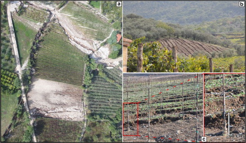
From field survey data, mean soil removal due to sheet and rill erosion was estimated at around 20–30 cm, as shown by the exposed roots of vines and olives ((c)). Indeed, most of the damage was borne by agriculture, which constitutes the main source of income for the area.
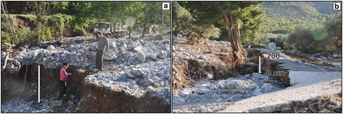
Areal erosion was coupled with linear erosion, mainly concentrated along the main channel of the alluvial fans (yellow portion in Map 2). The event dynamics were complex and developed through an initial stage of deposition, with lobes as high as 1 m, followed by channel erosion/exhumation ((a)). The channels were deepened and enlarged by deepening and lateral erosion and then filled in by debris flow deposits. In particular, the roads played a major role, becoming preferential flow paths and increasing the down-cutting of stream beds as deep as 1.5–2 m ((b)).
Figure 5. Main features of the alluvial fans reactivated in the eastern sector; (a) detail of a depositional and erosional area; (b) deep vertical incision along the roads from the mountain.
The streams of catchments 13, 14 and 21 remained confined within their channel beds as they are highly incised. The others remained confined in the portion between the topographic and hydrographic apexes, while downstream of the hydrographic apex exhibited several geomorphological responses, such as widening, deepening, and avulsion of the channel beds. Debris flow deposits settled along the main channel and all over the lobes and the active fans (Map 2). In general, there is a substantial difference in grain size between the apical sectors, consisting of large blocks of several dm3, and the median and distal sectors, mainly consisting of gravel between 2 and 10 cm in diameter and mud deposition (see pictures P6, P7, P8, P9, P10).
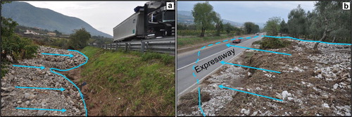
Debris flow propagation resulted in the overflowing of several urban centers and reached the Benevento – Caianello national expressway. The debris flow either stopped against the road embankment ((a)), or invaded both lanes where the road followed cuttings ((b)); traffic was interrupted and restored after several days.
Figure 6. Urban elements conditioning the flow; (a) the fan lobes stopped by the road embankment; (b) fan lobes that invaded the national expressway.
Additionally, the flow was strongly conditioned by the urban setting: it was diverted, slowed down and stopped. In a few cases the flow breached the walls of buildings along the flow path (see pictures P4 and P5 on the map).
Finally, 14.5 km of linear erosion was estimated to have affected 23 ha of fields; overall rill and gully erosion accounted for 100 ha, while debris deposition covered 63 ha of fields. Taken together, this corresponds to a damaged area of more than 180 ha and a loss of €7 million, estimated on the basis of mean agricultural values (CitationBURC, 2014).
5. Discussion and conclusions
The flash flood affecting the northern slope of Mt. Camposauro struck an area of nearly 14 km2. Although it resulted in no casualties, as it happened during the night (1:00–2:00 am), extensive damage was caused to roads, dwellings and fields. The post-event surveys, satellite images and UAV orthomosaic allowed all the erosional and depositional landforms present in the area to be accurately mapped. Nearly all the main roads were affected by debris deposition as much as 1 m deep, which transported cars, trees, electricity poles, etc. In many cases the flow hit roads parallel to the former channels, almost completely destroying them. As for damage to dwellings, only in a few cases were the outside walls of houses breached, resulting in flooding of the ground floors and basements, while doors, windows, stores and fences were commonly destroyed, with the flooding of gardens and yards. In all these cases damage was heavy and not easily repairable. By contrast, the damage caused by the considerable amount of coarse detrital bodies (blocks and gravels) deposited on the fields and the removal of the soil cover was more significant, strongly affecting the local economy, mainly based on agriculture and wine production. In particular, erosion processes affected an area of more than 120 ha, while aggradation covered 63 ha. The overall damaged area exceeding 180 ha and resulted in an economic loss of about €7 million.
The flash flood that affected the Paupisi – Solopaca area is a typical example of how even small stream basins with buried channel beds can be transformed in a few hours into a danger for downslope urban settlements. Indeed, the phenomena which occurred were characterized by high speeds and high water heights as well as considerable sediment transport, capable of inducing severe damage to property and people.
An invaluable tool for post-emergency management was also presented (Map 2). Such tools can greatly enhance hazard mapping for torrential floods and help local stakeholders plan detailed risk mitigation strategies.
Software
All the acquired field data and the photo-interpreted landforms were compared with images provided by Google Earth©. DTM production and map editing were performed using Esri ArcGIS 10.2. The final layout of the map was created using Corel Draw X7 TM.
POST FLASH FLOOD SURVEY: THE OCTOBER 14TH AND 15TH 2015 EVENT IN THE PAUPISI-SOLOPACA AREA (SOUTHERN ITALY).pdf
Download PDF (40.8 MB)Acknowledgements
The authors thank the regional hydrological and agrometeorological services (Centro Funzionale; Centro Agrometeorologico, Regione Campania) for providing the rainfall data and the Ministero dell’Ambiente, della Tutela del Territorio e del Mare for LiDAR data.
Disclosure statement
No potential conflict of interest was reported by the authors.
ORCID
Antonio Santo http://orcid.org/0000-0001-7825-8552
Giovanni Forte http://orcid.org/0000-0002-4127-7917
Melania De Falco http://orcid.org/0000-0002-6904-0946
Related Research Data
References
- Berti, M., & Simoni, A. (2007). Prediction of debris flow inundation areas using empirical mobility relationships. Geomorphology, 90, 144–161. doi:10.1016/j.geomorph.2007.01.014
- Bertolo, P., & Bottino, G. (2008). Debris-flow event in the Frangerello stream-Susa valley (Italy) – calibration of numerical models for the back analysis of the 16 October, 2000 rainstorm. Landslides, 5, 19–30. doi:10.1007/s10346-007-0099-7
- Blair, T. C., & McPherson, J. G. (1994). Alluvial fans and their natural distinction from rivers based on morphology, hydraulic processes, sedimentary processes, and facies. Journal of Sedimentary Research, 64(3a), 450–489. doi:10.1306/D4267DDE-2B26-11D7-8648000102C1865D
- BURC. (2014). Bollettino Ufficiale della Regione Campania n. 18 del 17/03/2014. Retrieved from http://burc.regione.campania.it/eBurcWeb/publicContent/archivio/archivio.iface
- CARG. (2010). Note illustrative della carta geologica d’Italia alla scala 1:50000, Foglio Caserta Est, no. 431, p. 140. Retrieved from http://www.isprambiente.gov.it/Media/carg/note_illustrative/431_Caserta_est.pdf
- Costa, J. E. (1988). Rheologic, geomorphic and sedimentologic differentiation of water floods, hyperconcentrated flows, and debris flows. In R. R. Baker, R. C. Kochel, & C. Patton (Eds.), Flood geomorphology (pp. 113–122). New York, NY: Wiley.
- De Falco, M., Forte, G., Santangelo, N., & Santo, A. (in press). Flash floods in torrential basins: The event of October 14th–15th 2015 in the surroundings of Benevento (southern Italy). Rendiconti Online – Società Geologica Italiana.
- Di Bucci, D., Massa, B., & Zuppetta, A. (2006). Relay ramps in active normal fault zones: A clue to the identification of seismogenic sources (1688 Sannio earthquake, Italy). Geological Society of America Bulletin, 118(3/4), 430–448. doi:10.1130/B25783.1
- Gaume, E., Bain, V., Bernardara, P., Newinger, O., Barbuc, M., Bateman, A., … Viglione, A. (2009). A compilation of data on european flash floods. Journal of Hydrology, 367, 70–78. doi:10.1016/j.jhydrol.2008.12.028
- Gaume, E., & Borga, M. (2008). Post-flooded investigations in upland catchments after major flash floods: Proposal of a methodology and illustrations. Journal of Flood Risk Management, 1, 175–189. doi:10.1111/j.1753-318X.2008.00023.x
- Hooke, R. L. (1967). Processes on arid region alluvial fans. Journal of Geology, 75(4), 438–460. Retrieved from http://www.jstor.org/stable/30085004 doi: 10.1086/627271
- Hurlimann, M., Copons, R., & Altimir, J. (2006). Detailed debris flow hazard assessment in Andorra: A multidisciplinary approach. Geomorphology, 78, 359–372. doi:10.1016/j.geomorph.2006.02.003
- IAHS-UNESCO-WMO (Ed.) (1974, September). Flash floods. Proceedings of the Paris symposium, publication 112.
- Magliulo, P., & Cusano, A. (2016). Geomorphology of the lower calore river alluvial plain (southern Italy). Journal of Maps, 12(5), 1119–1127. doi:10.1080/17445647.2015.1132277
- National Research Council. (1996). Alluvial fan flooding (pp. 1–131). Washington, DC: National Academy Press.
- Patacca, E., & Scandone, P. (2007). Geology of the southern Apennines. Bollettino della Società Geologica Italiana, 7, 75–119.
- Pelletier, J. D., Mayer, L., Pearthree, P. A., House, P. K., Demsey, K. A., Klawon, J. K., … Vincent, K. R. (2005). An integrated approach to flood hazard assessment on alluvial fans using numerical modeling, field mapping and remote sensing. Geological Society of America Bulletin, 117 (9/10), 1167–1180. doi:10.1130/B255440.1
- Pierson, T. C. (2005). Distinguishing between debris flows and floods from field evidence in small watersheds (USGS Fact Sheet 2004-3142), 4 pp. Retrieved from http://pubs.usgs.gov/fs/2004/3142/
- Santangelo, N., Daunis-i-Estadella, J., Di Crescenzo, G., Di Donato, V., Faillace, P., Martin-Fernandez, J. A., … Scorpio, V. (2012). Topographic predictors of susceptibility to alluvial fan flooding, southern Apennines. Earth Surface Processes and Landforms, 37, 803–817. doi:10.1002/esp.3197
- Santangelo, N., Santo, A., Di Crescenzo, G., Foscari, G., Liuzza, V., Sciarrotta S., & Scorpio V. (2011). Flood susceptibility assessment in a highly urbanized alluvial fan: the case study of Sala Consilina (southern Italy). Natural Hazards and Earth System Sciences, 11, 2765–2780. doi:10.5194/nhess-11-2765-2011.
- Santo, A., Ascione, A., Del Prete, S., Di Crescenzo, G., & Santangelo, N. (2011). Collapse sinkholes distribution in the carbonate massifs of central and southern Apennines. Acta Carsologica, 40(1), 95–112. doi:http://dx.doi.org/10.3986/ac.v40i1.31
- Santo, A., Di Crescenzo, G., Del Prete, S., & Di Iorio, L. (2012). The Ischia island flash flood of November 2009 (Italy): Phenomenon analysis and flood hazard. Physics and Chemistry of the Earth, 49, 3–17. doi:10.1016/j.pce.2011.12.004
- Santo, A., Santangelo, N., Di Crescenzo, G., Scorpio, V., De Falco, M., & Chirico, G. B. (2015). Flash flood occurrence and magnitude assessment in an alluvial fan context: The October 2011 event in the southern Apennines. Natural Hazards, 78, 417–442. doi:10.1007/s11069-015-1728-4
- Scorpio, V., Santangelo, N., & Santo, A. (2016). Multiscale map analysis in alluvial fan flood-prone areas. Journal of Maps, 12 (2), 382–393. doi:10.1080/17445647.2015.1027155
- Van Dine, D. F. (1985). Debris flows and debris torrents in the southern Canadian Cordillera. Canadian Geotechnical Journal, 22(1), 44–68. doi:10.1139/t85-006
- Wilford, D. J., Sakals, M. E., Innes, J. L., Sidle, R. C., & Bergerud, W. A. (2004). Recognition of debris flow, debris flood and flood hazard through watershed morphometrics. Landslides, 1, 61–66. doi:10.1007/s10346-003-0002-0