
ABSTRACT
The aim of this study is to present a new morphodynamic map (1:10,000 scale) of a wave-dominated sector of a Mediterranean ria-type coast (NE Sardinia, Italy). The area has been studied since 1995 with respect to its geomorphological and sedimentological processes. Our map is produced using topographic-bathymetric, textural and compositional data collected during different surveys conducted from 1995 to 2014. The Main Map shows forms, processes and deposits of the coastal belt, as well as the main geological outcrops, structural elements and the areal distribution of seagrass, mainly Posidonia oceanica (L.) Delile and Caulerpa prolifera (Forsskaal) Lamouroux. The map is useful for beach management purposes. It is noteworthy that the role of P. oceanica in the littoral area is twofold: (1) acts as a barrier to siliciclastic material from the backshore; and (2) a producer of biogenic/bioclastic sediment. Based on side-scan sonar images, the P. oceanica meadow appears to be threatened by direct mechanical damage caused by boat anchoring and mooring activities. The human impact on dune habitats has also been recognized and is related to pedestrian and vehicular transit, boat storage and infrastructure for bathing.
1. Introduction
We present here a morphodynamic map of a wave-dominated sector of Mediterranean ria-type coastal tract. The study area is located in NE Sardinia (Main Map), between Porto Pozzo and Punta Sardegna, and covers an area of about 35 km2. This system is characterized by a discrete accumulation of terrigenous sediment, creating a wave-dominated delta that is characterized by relatively high exposure to an open-sea swell. The Posidonia oceanica (L.) Delile meadow occurs along the whole studied marine sector. The area has been studied since 1995 (CitationCamin, 1996) with respect to its morpho-sedimentological features (CitationBartole & De Muro, 2012; CitationDe Muro, Kalb, Ibba, Ferraro, & Ferrara, 2010; CitationDe Muro, Pusceddu, & Kalb, 2010; CitationMastronuzzi et al., in press; CitationPusceddu, 2009) by researchers at the universities of Cagliari and Trieste ().
Table 1. Schematic summary of different studies and surveys carried out in the study area.
This coastal zone is of particular importance within the context of beach management, because it represents a complex environment characterized by several geomorphological features with specific dynamics, and is usually affected by human activity (e.g. CitationDe Muro & De Falco, 2015). Knowledge of beach dynamics can help to protect, conserve and manage the coastal zone. To achieve this objective, the geomorphological processes, distribution of sediment and the main human modifications have been highlighted in this study.
Major issues for the management of this coastal environment are linked to anthropic development (e.g. tourist pressure, road networks and related infrastructure). For the marine area, the main issue includes the modification of P. oceanica habitat by trawling and moorings.
The P. oceanica meadow ecosystem is a key coastal habitat, currently included as a priority natural habitat in the EC Directive 92/43/EEC (CitationEC, 1992, July 22). This plays a crucial role in the physical equilibrium of the Mediterranean coast (CitationVacchi, De Falco et al., 2016). The worldwide regression of the P. oceanica meadow ecosystem is one of the most pressing issues in marine environments (CitationBoudouresque, Bernard, Pergent, Shili, & Verlaque, 2009). This is threatened and under stress from many factors, such as direct disturbances that arise from marine activities, and shallow water turbidity caused by increased human pressure on the coastal zone. For this reason, its protection and the monitoring of its conservation status should be assured as part of a coastal management programme.
The main results of this research are summarized in a series of maps: (Main Map) a 1:10,000 morpho-sedimentological representation of the area; (Map 2) a map showing the sedimentary facies at 1:25,000 scale; (Map 3) a topographic and bathymetric profile map (at 1:25,000 scale); and (Map 4) a Side Scan Sonar (SSS) photomosaic and location map of sediment samples (at 1:25,000 scale).
The legend of the Main Map includes 80 terms, and is divided into 12 main sections: (1, 2) lithology and structural elements of the continental area; (3–5) forms, processes and deposits of the continental area; (6–10) forms, processes and deposits of the beach system; (11) topographic and bathymetric features and (12) man-made elements.
2. Study area
2.1. Geographical setting
The study area is located in NE Sardinia (W Mediterranean Sea), within the Bonifacio strait (Main Map). The coastal area, which extends for a total of 8 km, includes three rias (Porto Pozzo, Porto Liscia and Porto Pollo) and three main beaches: Porto Liscia, Porto Pollo and Padula Piatta (). The first beach extends for 3 km, and the second and third for 1 km each. The three beaches have developed, respectively, on W–E, NW–SE and SW–NE axes.
Figure 1. Hydrographic basin of the streams that flow into the three rias (Porto Pozzo, Porto Liscia and Porto Pollo).
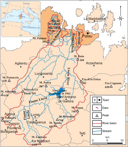
These beaches mainly receive sedimentary input from streams that flow into the three rias:
Riu de lu Calone, Riu Val di Mela and Riu lu Banconi (Porto Pozzo);
Liscia river (Porto Liscia);
Rio Scopa (Porto Puddu).
2.2. Coastal geomorphology
We can categorize the study area within the submerged coasts based on the earliest classification schemes (CitationBartole & De Muro, 2009, Citation2012; CitationDe Muro & Bartole, 2010). Refining the classification, and using the terminology adopted by CitationJohnson (1919), we can therefore categorize the area as a ria based on the role played by changes in sea level during the Quaternary. Meanwhile, if we use the CitationShepard (1963) scheme, we can classify the area as primary coast, resulting mainly from non-marine processes, including drowned river valleys and rocky and deltaic coasts. At the end of the Holocene, the coastline evolved into secondary coast with predominantly processes related to coastal dynamics (swash-aligned), as evidenced by the presence of beachrocks at shoreface depths (CitationCamin, 1996; CitationDe Muro, 1997; CitationDe Muro & Orrù, 1998; CitationVacchi, Marriner et al., 2016). Indeed, from this point onwards, its evolution was mainly controlled by marine processes.
Over the last two millennia, the L’Isuledda tombolo, which now has the tourist name of Porto Pollo, has been shaped by sediment contributions from the Liscia river. The P. oceanica meadow, acting as sediment retention body, has interrupted the dispersion of sediment to the sea. Now wave and tidal processes control the evolution (coastal morphodynamic processes) of this beach system. CitationWright and Thom (1977) introduced the term ‘coastal morphodynamics’, which is defined as ‘the mutual adjustment of topography and fluid dynamics involving sediment transport’.
In particular, according to CitationDavies (1980), who identified coastal types based solely on wave height and tidal range, we can now speak of microtidal wave-dominated beach systems and, more specifically, according to CitationDe Muro, Ibba, and Kalb (2016), of microtidal Mediterranean wave-dominated beach systems controlled by the P. oceanica meadow.
Currently, the Porto Pollo tombolo maintains its arrangement within the scenario of a microtidal wave-dominated Mediterranean beach, where the closing boundary towards the inner-shelf is controlled by the presence of the P. oceanica meadow. This is the result of the convergence of longshore currents and sediment transport into the shadow zone behind the tombolo, a result of wave refraction and diffraction. Using this knowledge, we can assert that the tombolo that the map is based on is a swash-aligned morphology.
The backshore, which is characterized by dunes related to sedimentary contributions and morphodynamics, evolved through a transformation from incipient to foredunes (on the W sector of the Liscia river mouth) and in transgressive dunes (parabolic with blowouts) with Ammophila arenaria (European marram grass) on the E sector of the Liscia river mouth and in the E-most part of the tombolo (CitationHesp, 1999). In this area, the dunes provide a new sediment supply to the beach, but the dune habitats appear to be endangered by human impact related to pedestrian and vehicular transit, boat storage and the settlement of seasonal infrastructure for bathing (e.g. kiosks). These structures also limit the deflation processes and the transport of sediment in the eastern beaches. The hardening of the tombolo, which was caused by the construction of a road between it and the coast, has had an additional impact, because it causes the erosion of the Porto Puddu beaches. In contrast, beaches located in the western sector are stable due to the annual nourishment of sediment from the Liscia river.
2.3. P. oceanica meadow
The ecogeomorphological role of P. oceanica meadow in Mediterranean coastal environments has been investigated by numerous studies (e.g. CitationBatzella et al., 2011; CitationBoudouresque et al., 2012; CitationPusceddu et al., 2011; CitationSimeone, De Muro, & De Falco, 2013; CitationTecchiato, Buosi, Ibba, Ryan, & De Muro, 2016; CitationVacchi, De Falco et al., 2016). P. oceanica meadow occurs along the whole studied coastal sector. In this area, this habitat plays a fundamental role, acting as: a siliciclastic barrier from the backbeach/backshore and a producer of biogenic/bioclastic material. In addition, the meadow attenuates waves and currents from the Strait of Bonifacio and reduces sediment resuspension. It also guarantees the stability of the zones affected by erosion contributing to shoreline stabilization.
2.4. Surf zone morphodynamics
On the W side of the tombolo (Porto Liscia beach), the surf zone extends up to 300 m in front of the Liscia river mouth. Meanwhile, the beaches located on the E side (Porto Pollo and Padula Piatta) are characterized by a surf zone of about 150 m. Four morphodynamic states have been recognized in the studied beaches following CitationWright and Short’s (1984) classification. Porto Liscia ranges from an intermediate (Longshore Bar Trough (LBT), Rhythmic Bar and Beach (RBB), Transverse Bar and Rip (TBR)) to a reflective beach in the W sector; Porto Pollo is classified as a reflective beach; and the Padula Piatta beach varies from intermediate (TBR, Low Tide Terrace (LTT)) in the SW sector to reflective in the NE.
2.5. Geological setting
The Main Map has been produced in a marine-coastal area (Gallura, ) that is mainly constituted of Paleozoic intrusive granitoid rocks belonging to plutons of the Sardinian-Corsican Hercynian batholith (Upper Carboniferous-Permian, CitationCarmignani et al., 2008; CitationVV.AA., 2008). The outcropping rocks are part of a calc-alkaline complex that extends from S Sardinia to N Corsica.
Figure 2. Geological scheme of the study area (CitationVV.AA., 2008).
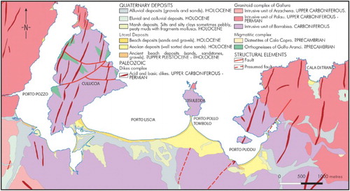
The Hercynian batholith occupies an area of about 6000 km2 in Sardinia, and is mainly located in the E sector, along a NNW–SSE oriented belt. Based on geological, compositional and textural features, the granitoids of the batholith are grouped into three main categories: early syn-tectonic plutons (up to 9% of the batholith), late-tectonic plutons (up to 74%) and post-tectonic plutons.
The first of these plutons, which are of an uncertain age, are composed of rocks with a variable composition (from tonalitic to leucogranitic) that are characterized by a marked foliated texture (e.g. the ‘Barrabisa’ facies).
The monzogranites, characterized by an oriented texture caused by the magmatic flow, are mainly located in N Sardinia and, in particular, Gallura. These belong to the late-tectonic plutons that settled down about 300 million years ago (e.g. the facies ‘M. di la Lescia’ and ‘Lovia Avra’).
The leucogranite, which outcrops in lodes and masses and is attributable to the post-tectonic plutons (<290 M. y.), has compositional homogeneity and a remarkable textural variety. It is also characterized by an isotropic texture and has a medium- (e.g. the facies of ‘Vallicciola’ and ‘Oschiri and San Giorgio’) to fine-grained microgranular facies (e.g. ‘Punta Bozzico’).
On the Main Map, the mapping of the granitoid complex has been drawn according to criteria that have allowed us to distinguish the intrusive units on the basis of compositional and textural homogeneity and spatial distribution.
In the examined area and in its surroundings (from Arzachena to Vignola), four intrusive units, called respectively, ‘Unità intrusiva di Barrabisa, Unità intrusiva di Palau, Unità intrusiva di Porto Rotondo and Unità intrusiva di Arzachena s.s.’, have been recognized. The last of these, which is extremely wide, occupies part of the W sector of Gallura, which also includes the studied area.
In particular, the facies of the ‘Unità di Arzachena’ subunit of ‘Intrusiva di M. Tiana’ is characterized by a monzogranitic facies constituting an intrusive N120-elongated complex (along the Arzachena-Luogosanto-Bassacutena direction).
All the outcrops are covered by soil with gravelly and sandy horizons produced by the in-situ erosion of granite, and by colluvial detritus and only a few alluvial deposits.
A dike complex that is typical of NE Sardinia is also present, and principally oriented NNE–SSW and N–S. It is characterized by a basalt composition, veins of granitic porphyries, masses of microgranites, and aplitic and pegmatitic veins (CitationCarmignani et al., 2001, Citation2008).
The Quaternary lithologies are mainly characterized by Pleistocene and Holocene deposits, with the former made up of terraced alluvial gravel with subordinate sand (upper Pleistocene).
‘Ancient’ beach deposits are present, with a thickness up to 3–4 m, and are made up of sand, sandstones, calcirudites, bivalve gravel, gasteropods with subordinate sandy-silty deposits, and calcilutites (?upper Pleistocene-?Holocene). The Holocene deposits belong to both littoral and alluvial environments (CitationVV.AA., 2008).
In the shoreface area of the Porto Pollo tombolo, sandstones and conglomerates in the facies of the beachrocks crop out. According to previous studies (CitationCamin, 1996; CitationDe Muro, 1997; CitationDe Muro & Orrù, 1998; CitationVacchi, Marriner et al., 2016), their presence, at a depth of shoreface, is due to the Late Holocene sea-level highstand.
3. Methods
The integrated geological, geomorphological, sedimentological and marine-coastal dynamic studies were carried out following the methodological protocols and standards used, tested and developed by the Coastal and Marine Geomorphology Group (CitationBrambilla, van Rooijen, Simeone, Ibba, & DeMuro, 2016; CitationDe Muro, Batzella, De Falco, & Porta, 2010; CitationDe Muro, Kalb, et al., 2010; CitationDe Muro, Kalb, Pusceddu, & Ibba, 2013).
This study was focused on coastal management with dynamic elements (like beach scarps, bars and troughs, deflation surfaces) introduced on a map that generally tends to represent static issues. These items are identified using recent aerial photos and are mapped as static elements.
3.1. Topographic and bathymetric surveys
The digital data for the marine area were acquired using different instruments:
Single beam Echosounder (SB):
ELAC Nautik LAZ 51 with ELAC Nautik LSE 131.
Reson Navisound 215 (frequency 200/33 KHz), with Omnistar 8300HP diferential global positioning system (DGPS) receiver.
Sub Bottom Profiler (SBP) Datasonics CHIRP II.
SSS:
digital recording unit CODA DA200, with tow fish Edgetech DF1000.
analog recording unit EG&G model 260, with tow fish EG&G Model 272.
SSS and SBP data constituted the base data for the initial characterization of the seabed. The seismic facies, identified by CitationBartole and De Muro (2012), have been related to the planimetric data produced by SSS. The sedimentary limits, the bedrock, the presence of seabed forms and the areas colonized by a seagrass ecosystem (mainly P. oceanica meadow and Caulerpa prolifera (Forsskaal) Lamouroux) were also identified (CitationFish & Carr, 1990; CitationPusceddu, 2009).
3.2. Sedimentary facies
Based on these acoustic facies’ maps, sediment sampling areas were identified and 272 sediment samples collected. A Van Veen grab with a 5 dm3 capacity was used for the shoreface and inner-shelf sampling (231 samples and 19 observation points), while 41 sediment samples were collected on the backshore. The grain size distribution was determined following the ASTM international standard methodology, with sieves spaced at ¼ and 1Φ between 2000 μm and 50 μm (CitationWentworth, 1922). The textural sediment classification and the grain size parameters were obtained using the Folk & Ward scale (CitationFolk, 1966; CitationFolk & Ward, 1957) for the backshore-backbeach samples and the Nota scale (CitationNota, 1958) for the shoreface and inner-shelf samples.
The mineralogical and petrographical composition of the sediment for each sample was established under an optical microscope in order to distinguish quartz, feldspars, micas, other minerals, lithoclasts and skeletal grains. The volume percentage of each mineralogical class was recognized using the areal comparison method (CitationLewis & McConchie, 1994).
Several sedimentary facies were identified based on the grain size, mineralogical and petrographical composition of the sediment and the relative abundance of siliciclastic and bioclastic components (CitationDe Falco, De Muro, Batzella, & Cucco, 2011; CitationDe Muro et al., 2016; CitationLecca, De Muro, Cossellu, & Pau, 2005).
4. Results
4.1. Grain size and compositional analysis
Grain size analyses, performed on backshore and backbeach samples, reveal an increase in the average size of the sediment from the shoreline to the berm and a decrease towards the dunes (according to a classical model of shoreline-slope dispersion). Coarse sediment is predominant on the shoreline and on the backshore-backbeach (coarse sand 41%, very coarse sand 26%, gravel 15%; (a)). On the shoreface, the sediment varies mainly from medium sand to mud (medium sand 18%, fine sand 10%, very fine sand 9% and mud 33%).
Figure 3. (a) Textural charts; (b) compositional charts.
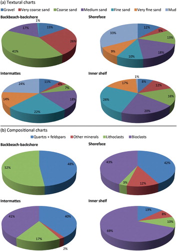
The average sediment grain size decreases from the shoreface towards the upper limit of P. oceanica meadow. The surf zone is characterized by coarse and medium sand, whereas close to the P. oceanica meadow upper limit, mud sediment becomes dominant. The intermattes are mainly composed of sand (22% fine sand and 18% medium sand) and mud (24%; (a)), while the inner-shelf shows a predominance of sandy sediment (26% fine sand, 20% medium sand and 17% very fine sand; (a).
The backshore-backbeach sediment is composed of 52% lithoclasts and 48% quartz + feldspar. The compositional analysis also reveals a progressive enrichment in bioclasts from the shoreface to the inner-shelf, ranging from 0% to 90% (close to the P. oceanica meadow upper limit; (b)). On the inner-shelf, bioclasts become significant in the intermattes (about 41%) and of the lower limit of the meadow (about 70%; (b)).
4.2. Sedimentary facies and benthic habitats
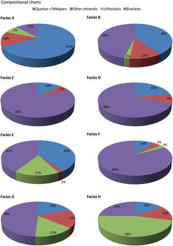
Eight sedimentary facies (A–H) have been described in the study area (Map 2). A siliciclastic-dominated facies, with mainly sandy and gravelly sediment, was identified on the shoreface close to the shoreline (Facies A; and ). The shoreface is also characterized by a mixed bioclastic and siliciclastic facies that is mainly composed of mud (Facies B; Map 2). A mixed bioclastic–siliciclastic facies (Facies C) with gastropods and bivalves has been recognized between the shoreface and the upper limit of P. oceanica meadow ( and ). Sandy mud with bivalves of the shoreface constitutes Facies D (Map 2), which is composed of mud and fine sand that is mainly biogenic. Facies E is characterized by the mixed bioclastic and siliciclastic gravelly-muddy sand of the intermattes. The sediment of P. oceanica meadow’s lower limit is composed of bioclastic detritic (mixed gravelly sand and muddy sand, Facies F; Map 2). In the deepest zones, the sedimentary facies are composed of mixed detritic, bioclastic and siliciclastic gravelly sand (Facies G) and siliciclastic detritic (mainly quartz and lithoclast) sand (Facies H; and ).
Figure 4. Textural charts of the sedimentary facies.
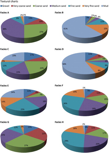
Figure 5. Compositional charts of the sedimentary facies.
Four main benthic habitats and substrate types were identified: (1) an uncolonized sediment substrate; (2) rocky outcrops; (3) P. oceanica meadow; and (4) a sea bottom colonized by C. prolifera. ‘Barren’ substrates dominate the seafloor between the shoreline and the upper limit of the P. oceanica meadow. The rocky substrates are situated near the coastline in the NW and NE sectors of the study area. A continuous meadow of P. oceanica occurs in the depth range –5 to –35 m, whereas the C. prolifera habitat was observed along the shoreline at up to –10 m in the NE sites near the Porto Puddu beaches (Map 2). Based on SSS images, the P. oceanica meadow habitat appears to be threatened by direct mechanical damage caused by boat anchoring and mooring activities, mainly in the sector to the W of L’Isuledda, as marked on the map (Main Map).
5. Discussion
Data collected have allowed us to reconstruct the geomorphological evolution of this beach system, including its backbeach, backshore, shoreface and inner-shelf. According to the classification schemes of the coast, the studied beaches can firstly be categorized as rias based on the role played by changes in the sea level during the Quaternary. The beaches constitute a primary coast, because they are controlled by non-marine processes (including drowned river valleys and rocky and deltaic coasts). Over the last two millennia, the coastline has evolved into secondary coasts (mainly controlled by marine processes), as evidenced by the presence of beachrocks.
The distribution of the sediment has been mapped using grain size and compositional data. The siliciclastic sediment is redistributed along the shoreface between the shoreline and the upper limit of the P. oceanica meadow. A transitional zone, located between the shoreface and the seagrass domain, is characterized by an increase of biogenic and bioclastic sediment mixed with a siliciclastic component. Only a small amount of bioclastic sediment is distributed in the surf zone or backshore. Most of the carbonatic production, which is related to the marine phanerogams, is distributed within the meadow and below its lower limit.
The P. oceanica meadow physically retains sediment arising from rock coast decay and erosion, guaranteeing the integrity of the beach with all its sedimentary bodies (backbeach, backshore and shoreface). The meadow also contains terrigenous sedimentation between the coastline and its upper limit.
The main critical environmental aspects of the area are linked to anthropic developments. In particular, the fluvial inputs of the Liscia river appear to have halved (about 282 of 564 km2) since 1961, when the dam closed.
The hardening of the tombolo, caused by the construction of a road between the coast and L’Isuledda, has had an additional impact (e.g. from the deposition of stone blocks in order to protect the area from the NE waves, and the seasonal rebuilding of the road surface). This structure has caused shoreline retreat of the Porto Puddu beaches (located E of the tombolo), although these erosional effects have been limited by the rearrangement of the beaches. The dispersion of sediment, linked to the westerly wind, has partially compensated for the reduction in sediment transport due to the anthropic stabilization of the tombolo, limiting the erosion of the E beaches. In this sector, the deflation processes are also restricted by the presence of kiosks on the tombolo.
The beaches located in the W sector of the study area (Porto Liscia) are stable due to the annual nourishment of sediment from the Liscia river. On the W side of the tombolo, the beaches are influenced by the turbulent layer of water that washes up on the beach after an incoming wave (swash) on the man-made forms (road and kiosks).
6. Conclusions
This paper provides a detailed 1:10,000 morpho-sedimentological map of a Mediterranean embayed beach system and its related inner-shelf in NE Sardinia. The system is produced by rias and is characterized by a marine phanerogam meadow. This map constitutes an innovative and useful tool for the management of this coastal sector. The knowledge of beach dynamics, the geomorphological processes, distribution of the sediment and the main human modifications provide the scientific baseline to protect, conserve and manage the coastal zone.
Software
The SSS sonograms were conducted using Swan Pro 2.00 and Swan Mosaic1.10 (Communication Technology). Single Beam data from 2006 to 2008 were acquired and manipulated using Reson PDS2000, while the DGPS data were manipulated using GNSS Solutions software.
The textural data were produced using Gradistat software in Microsoft Excel (CitationBlott & Pye, 2001).
The sample data and the SSS data were processed using Autodesk Map 3D to obtain the granolumetric distribution of the sediment and identify the main habitat. The topographic and bathymetric data were then processed with Global Mapper 14 to produce a land-sea digital elevation model.
QGIS software was used to compile the complete database to enable us to identify the geomorphological features and produce the map. The digital cartography was completed using Adobe Illustrator CS5.
Morphodynamics of a Mediterranean microtidal wave-dominated beach: forms, processes and insights for coastal management.pdf
Download PDF (8.8 MB)Acknowledgements
The authors would like to thank ‘Corpo Forestale e di Vigilanza Ambientale CFVA’ and all members of BLON. Palau. Thanks also go to the ‘Coastal and Marine Geomorphology Group’ of Cagliari University and to the staff of ‘Osservatorio Coste E Ambiente Naturale Sottomarino OCEANS’.
Disclosure statement
No potential conflict of interest was reported by the authors.
Related Research Data
References
- Bartole, R., & De Muro, S. (2009). Features and bedforms of the last eustatic cycle in the La Maddalena Archipelago (North Sardinia, Italy) from high-resolution acoustic data. In Proceedings of the “27th IAS Meeting of Sedimentologists”, Alghero (Italy), September 20–23, 2009, Medimond International Proceeding. pp.79–84.
- Bartole, R., & De Muro, S. (2012). Acoustic facies and seabed features of the mixed carbonate-siliciclastic deposits of the last eustatic cycle in the la Maddalena Archipelago (North Sardinia, Italy). Italian Journal of Geosciences, 131(1), 102–122. doi:10.3301/IJG.2011.28
- Batzella, T., Pusceddu, N., Kalb, C., Ferraro, F., Ibba, A., & De Muro, S. (2011). Bars and troughs dynamic and evolution trend of La Cinta beach (San Teodoro OT) – NE Sardinia. Rendiconti Online Della Società Geologica Italiana, 17, 17–23. doi:10.3301/ROL.2011.13
- Blott, S. J., & Pye, K. (2001). GRADISTAT: A grain size distribution and statistics package for the analysis of unconsolidated sediments. Earth Surface Processes and Landforms, 26(11), 1237–1248. doi:10.1002/esp.261
- Boudouresque, C. F., Bernard, G., Bonhomme, P., Charbonnel, E., Diviacco, G., Meinesz, A., … & Tunesi, L. (2012). Protection and conservation of posidonia oceanica meadows. Tunis: RaMoGe and RAC/SPA.
- Boudouresque, C. F., Bernard, G., Pergent, G., Shili, A., & Verlaque, M. (2009). Regression of Mediterranean seagrasses caused by natural processes and anthropogenic disturbances and stress: A critical review. Botanica Marina, 52, 395–418. doi: 10.1515/BOT.2009.057
- Brambilla, W., van Rooijen, A., Simeone, S., Ibba, A., & DeMuro, S. (2016). Field observations, coastal video monitoring and numerical modeling of coastal processes at Poetto Beach, Italy. Journal of Coastal Research, Special Issue, 75, 825–829. doi: 10.2112/SI75-166.1
- Camin, M. (1996). Sedimentologia e geomorfologia della fascia costiera tra Punta Don Diego e la Penisola di Culuccia (Sardegna settentrionale). (Degree thesis). Università degli Studi di Trieste, Trieste.
- Carmignani, L., Oggiano, G., Barca, S., Salvadori, I., Eltrudis, A., Funedda, A., & Pasci, S. (2001). Memorie descrittive dalla Carta Geologica d’Italia – Geologia della Sardegna. Rome: Istituto Poligrafico e Zecca dello Stato.
- Carmignani, L., Oggiano, G., Funedda, A., Conti, P., Pasci, S., & Barca, S. (2008). Geological map of Sardinia – 1:250,000 scale map. Rome: Servizio Geologico d’Italia.
- Davies, J. L. (1980). Geographical variation in coastal development (2nd ed.). New York, NY: Longman.
- De Falco, G., De Muro, S., Batzella, T., & Cucco, A. (2011). Carbonate sedimentation and hydrodynamic pattern on a modern temperate shelf: The strait of Bonifacio (western Mediterranean). Estuarine, Coastal and Shelf Science, 93(1), 14–26. doi:10.1016/j.ecss.2011.03.013
- De Muro, S. (1997). Aspetti geomorfologici e cronologici di paleolinee di riva sommerse oloceniche nella piattaforma prossimale tra Capo Ferro e Capo di Monti Russu (Sardegna nord-orientale, Italia). Memorie della Società Geologica Italiana, 52, 309–322.
- De Muro, S., & Bartole, R. (2010). Morfologie e strutture sedimentarie dell’ultimo ciclo eustatico nei canali dell’Arcipelago di La Maddalena (sardegna settentrionale). In S. De Muro & G. De Falco (Eds.), Manuale per la gestione delle spiagge – Studi, indagini ed esperienze sulle spiagge Sarde e Corse (pp. 59–102). Cagliari: University press – Scienze Costiere e Marine, CUEC.
- De Muro, S., Batzella, T., De Falco, G., & Porta, M. (2010). Sedimentological map of Bonifacio Strait inner shelf. Rendiconti Online Societa Geologica Italiana, 11, 752–753.
- De Muro, S., & De Falco, G. (2015). Handbook of best practices for the study, monitoring and management of Sardinian beaches. Cagliari: University Press – Scienze Costiere e Marine, CUEC Editrice.
- De Muro, S., Ibba, A., & Kalb, C. (2016). Morpho-sedimentology of a Mediterranean microtidal embayed wave dominated beach system and related inner shelf with Posidonia oceanica meadows: The SE Sardinian coast. Journal of Maps, 12(3), 558–572. doi:10.1080/17445647.2015.1051599
- De Muro, S., Kalb, C., Ibba, A., Ferraro, F., & Ferrara, C. (2010). Sedimentary processes, morphodynamics and sedimentological map of “Porto Campana” SCI beaches (Domus de Maria – SW Sardinia). Rendiconti Online Della Società Geologica Italiana, 11, 756–757.
- De Muro, S., Kalb, C., Pusceddu, N., & Ibba, A. (2013). The activity of “Osservatorio Coste E Ambiente Naturale Sottomarino” (OCEANS) and the implementation of a monitoring network and study methodology for sedimentological and morphodynamic processes of Mediterranean microtidal wave-dominated beaches (Sardinia). In L. E. Cipriani (Ed.), Coastal erosion monitoring. A network of regional observatories. Results from ResMar project (pp. 95–109). Firenze: Regione Toscana.
- De Muro, S., & Orrù, P. (1998). Beach-rock's contribution in the study of the modalities of the olocenic sea rising. Post-glacial beach-rocks of the North-East Sardinia [Il contributo delle beach-rock nello studio della risalita del mare olocenico. Le beach-rock post - glaciali della Sardegna nord-orientale]. Alpine and Mediterranean Quaternary, 11(1), 19–39.
- De Muro, S., Pusceddu, N., & Kalb, C. (2010). Sedimentological map of the seafloor between Porto Pozzo Bay and Capo Ferro - NE Sardinia. Rendiconti Online Società Geologica Italiana, 11, 758–759.
- EC. (1992, July 22). Council Directive 92/43/EC on the conservation of natural habitats and of wild fauna and flora. Official Journal of the European Communities, L, 206.
- Fish, J. P., & Carr, H. A. (1990). Sound underwater images: A guide to the generation and interpretation of side scan sonar data. Orleans, MA: Lower Cape Pub.
- Folk, R. L. (1966). A review of grain-size parameters. Sedimentology, 6, 73–93. doi: 10.1111/j.1365-3091.1966.tb01572.x
- Folk, R. L., & Ward, W. (1957). Brazos river bar: A study in the significance of grain size parameters. Journal of Sedimentary Petrology, 27(1), 3–26. doi: 10.1306/74D70646-2B21-11D7-8648000102C1865D
- Hesp, P. (1999). The beach, backshore and beyond. In A. D. Short (Ed.), Handbook of beach and shoreface dynamics (pp. 145–169). Chichester: Wiley and Sons.
- Johnson, J. W. (1919). Shore processes and shoreline development. New York, NY: Wiley.
- Lecca, L., De Muro, S., Cossellu, M., & Pau, M. (2005). I sedimenti terrigeno-carbonatici attuali della piattaforma continentale del Golfo di Cagliari. Il Quaternario (Italian Journal of Quaternary Science), 18(2), 201–221.
- Lewis, D. W., & McConchie, D. (1994). Practical sedimentology. New York, NY: Chapman & Hall.
- Mastronuzzi, G., Aringoli, D., Aucelli, P., Baldassarre, M. A., Bellotti, P., Bini, M., … Valente, A. (in press). The geomorphological map of the Italian coast: From a descriptive to a morphodynamic approach. Geografia Fisica e Dinamica Quaternaria.
- Nota, F. J. G. (1958). Sediments of the western Guiana shelf. Report of the Orinoco Shelf expedition, 2. Wageningen: Veenman & Zones.
- Pusceddu, N. (2009). Caratterizzazione sedimentologica della piattaforma interna dell’Arcipelago di La Maddalena: studio e modellizzazione di tre spiagge campione. (PhD Thesis in Earth Science). Cagliari University, 186.
- Pusceddu, N., Batzella, T., Kalb, C., Ferraro, F., Ibba, A., & De Muro, S. (2011). Short-term evolution of Budoni beach on NE Sardinia. Rendiconti Online Della Società Geologica Italiana, 17, 155–159. doi:10.3301/ROL.2011.45
- Shepard, F. P. (1963). Submarine geology (2nd ed.). New York, NY: Harper & Row.
- Simeone, S., De Muro, S., & De Falco, G. (2013). Seagrass berm deposition on a Mediterranean embayed beach. Estuarine, Coastal and Shelf Science, 135, 171–181. doi:10.1016/j.ecss.2013.10.007
- Tecchiato, S., Buosi C., Ibba, A., Ryan, D. A., & De Muro, S. (2016). A comparison of geomorphic settings, sediment facies and benthic habitats of two carbonate systems of western Mediterranean Sea and south Western Australia: Implications for coastal management. Journal of Coastal Research, Special Issue, 75, 562–566. doi:10.2112/SI75-113.1
- Vacchi, M., De Falco, G., Simeone, S., Montefalcone, M., Morri, C., Ferrari, M., & Bianchi, C. N. (2016). Biogeomorphology of the Mediterranean Posidonia oceanica seagrass meadows. Earth Surface Processes and Landforms. doi:10.1002/esp.3932
- Vacchi, M., Marriner, N., Morhange, C., Spada, G., Fontana, A., & Rovere, A. (2016). Multiproxy assessment of holocene relative sea-level changes in the western Mediterranean: Sea-level variability and improvements in the definition of the isostatic signal. Earth-Science Reviews, 155, 172–197. doi: 10.1016/j.earscirev.2016.02.002
- VV.AA. (2008). Carta Geologica di base della Sardegna – 1:25,000 scale map. Regione Autonoma della Sardegna. Retrieved from http://www.sardegnageoportale.it/argomenti/cartageologica.html
- Wentworth, C. K. (1922). A scale of grade and class terms for clastic sediments. Journal of Geology, 30, 377–392. doi: 10.1086/622910
- Wright, L. D., & Short, A. D. (1984). Morphodynamic variability of surf zones and beaches: A synthesis. Marine Geology, 56, 93–118. doi: 10.1016/0025-3227(84)90008-2
- Wright, L. D., & Thom, B. G. (1977). Coastal depositional landforms: A morphodynamic approach. Progress in Physical Geography, 1, 412–459. doi: 10.1177/030913337700100302