
ABSTRACT
The paper presents complex results of a dataset related to the pseudokarst caves in the area of the Czech Outer Western Carpathians. We collected the data from all 130 discovered and described caves of different types and dimensions in various geomorphic units and lithologies. We mainly focus on the results of the morphometric parameters of the caves as well as of the areas with their entrances. The final map sheet presents the Main Map with the position of the caves, their size category, type, classification of the position within the slope deformation and natural protection status. Moreover, the final map sheet also contains a supplementary map of the distribution of the caves, diagrams of their morphometric parameters, detailed maps of Mraznica and Cyrilka Caves, a graph of overwintering bat species in Cyrilka Cave and structural measurement diagrams. The map is intended to be used as introductory material into the problems of pseudokarst caves.
1. Introduction
The term pseudokarst has recently been used to refer to forms resembling karst morphology, but primarily to those produced by process other than dissolution (CitationHalliday, 2007). A pseudokarst cave is any cave that only originated in insoluble rocks by mechanical forces (CitationPanoš, 2001). Pseudokarst caves are then traditionally distinguished as fissure caves, cave niches, bedding type caves, crevice type caves, talus type caves and combined type caves (CitationVítek, 1983).
A total of 130 pseudokarst caves of various types have been recorded in the easternmost part of Czechia (synonym to the Czech Republic). Pseudokarst caves have so far been investigated as unique cases, without any data summarisation. This paper offers a general overview of the parameters of the caves such as morphometric data, locations in relation to lithology and geomorphic units, relation to slope deformations, inclusion in different classifications and the form of protection. These parameters are visualised on the map, using various cartographic techniques, maps and diagrams.
1.1. Study area
The region is formed by a mountainous area that is a part of the Outer Western Carpathians ((a)). More specifically, it is a broader continuous belt that stretches from Austria, through Czechia and Slovakia to Poland. The Czech part, which covers an area of ca. 7140 km2, consists of flysch rocks, deposited from the Early Cretaceous to the Palaeogene as turbidites in the Tethys Sea (CitationPicha, Stráník, & Krejčí, 2006). The rock sequences are mostly formed by proximal turbidity facies represented by sandstones and conglomerates and distal facies formed by shales or claystones. The rock mass was folded during phases of the Alpine Orogeny in the Palaeogene and the Neogene and the whole structure was thrust northward onto the Miocene sedimentary foredeep and Palaeozoic basement (CitationPicha et al., 2006). The thrust structure makes several nappes (e.g. Silesian and Rača Nappes) very pronounced from the NW to SE, each overlying the preceding one in the stratigraphical superposition. The resulting formations of SW–NE elongated ridges, uplifted and eroded during the Late Neogene-Quaternary (CitationDanišík, Pánek, Matýsek, Dunkl, & Frisch, 2008), have recently been dissected by deeply incised valleys.
Figure 1. (a) Study area within Czechia. (b) Study area – hypsometry, caves, and geomorphic units (1 – Podbeskydská pahorkatina Highland, 2 – Slezské Beskydy Mts, 3 – Jablunkovské mezihoří Highland, 4 – Moravskoslezské Beskydy Mts, 5 – Vsetínské vrchy Hills, 6 – Hostýnské vrchy Hills, 7 – Javorníky Mts, 8 – Vizovická vrchovina Highland, 9 – Chřiby Highland). Only geomorphologic units containing caves are presented.
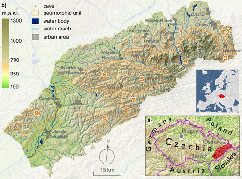
The whole area is traditionally divided into different geomorphic units (CitationDemek & Mackovčin, 2006) ((b)) with the most distinct unit being that of the Moravskoslezské Beskydy Mts and its highest summit the Lysá hora Mt. (1323 m.a.s.l.). This range consists of the more than 3 km thick Godula Formation (Late Cretaceous). Other significant geomorphic units are the Javorníky Mts and the Vsetínské vrchy Hills, both with their highest summits above 1 000 m.a.s.l. Other geomorphic units are formed by lower uplands the elevation of which gradually decreases to the SW.
As a result of the napped structure of the mountain belt, the rock layers of the Silesian Nappe are slightly inclined, mostly to the S, SE or SW, forming asymmetrical monoclinal ridges with steep northward oriented escarpments and gently inclined opposite dip slopes. The geological units of the Rača Nappe are folded, forming symmetrical and isoclinal ridges, sometimes with inverted topography (CitationPánek & Lenart, 2016).
The weak and incoherent flysch rock formations are strongly prone to deep-seated slope deformations (CitationPánek & Lenart, 2016) that are primarily triggered by heavy rains or rapid snowmelts (CitationKrejčí et al., 2002; CitationPánek, Šilhán et al., 2011). Slope deformations of various types are the main geomorphic agent in the area (CitationPánek & Lenart, 2016) to such an extent that they affect particular slopes and entire mountain ridges repeatedly (CitationPánek, Šilhán et al., 2011). In places, whole mountain massifs are gravitationally disintegrated (CitationPánek, Tábořík et al., 2011). As a result of these processes, typical landforms have developed: double-crested ridges, headscarps with exposed rock walls, rocky trenches, huge slide rock blocks, landslide dams with lakes and pseudokarst caves (CitationPánek & Lenart, 2016). It is mainly deep-seated slope deformations that are commonly accompanied by crevice type caves (CitationLenart, Pánek, & Dušek, 2014). Talus type caves are formed in the middle or lower segments of deep-seated slope deformations. Joint and bedding type caves occur only rarely. These two types, which are usually structurally predisposed, only occasionally develop in the headscarp areas of slope deformations.
Being a singular phenomenon in the Silesian Nappe, a small island of Jurassic limestones has been identified in the northern part of the investigated area. The limestones form several isolated hills underlain by flysch rocks. Although several short karst caves have formed in the limestones, the process of gravitational disintegration of the mountain ridges that has produced crevice type caves is more prominent.
1.2. Existing knowledge of the caves in the study area
The pseudokarst caves in the study area have been explored quite recently, although some of them have been known from historic times and they were probably used as storage for milk and cheese by old shepherds (CitationČetyna, 1966). Modern exploration and investigation of these caves started in 1953 when CitationTučník (1953) described the first crevice type cave in the area. The methods of the first research were very primitive. Basic mapping consisted with the use of mining lamps and climbing on hemp ropes without any additional equipment (CitationWagner, Demek, & Stráník, 1990). The first group of cavers was established in the region in 1969. The largest and the deepest caves were mapped by CitationFoldyna (1968), CitationFoldyna and Pavlica (1968) and CitationWagner et al. (1990). The investigation was focused on talus type caves and especially crevice type caves but almost always separately from the investigation of gravitational slope deformations. The research of these two phenomena was interconnected in the new millennium (CitationBaroň, Cílek, & Melichar, 2003; CitationKlimeš et al., 2012; CitationLenart et al., 2014; CitationPánek et al., 2010). Thanks to the existence of the open underground space, there is a unique chance to study the internal structure of landslide bodies from within (CitationBaroň, Bečkovský, & Míča, 2014; CitationLenart et al., 2014; CitationMargielewski & Urban, 2003). Pseudokarst caves have become a source of information on landscape evolution.
There are several recent papers that should be introduced concerning pseudokarst cave investigations. First, a comprehensive overview of pseudokarst caves in the region was provided by CitationWagner et al. (1990). The work is valuable for its accurate maps of the caves. CitationLenart et al. (2014) conducted a regional geomorphic study that interconnects the research of gravitational slope deformations with the research of crevice type caves. Several minor studies deal with this research area as well (CitationBaroň, 2004; CitationBaroň et al., 2003; CitationPánek, Tábořík, & Hradecký, 2007). Some other studies particularly involve issues related to pseudokarst caves (CitationBaroň et al., 2014; CitationKlimeš et al., 2012). An overview of the morphology of crevice type caves was provided by CitationLenart (2015). Also studies conducted outside the study area, but that deal with a similar topic, should be noted. CitationMargielewski and Urban (2003) investigated crevice type caves in relation to the evolution of gravitational slope deformations in the Polish Flysch Carpathians. Later they provided a morphogenetic classification of the caves connected with gravitational slope development (CitationUrban & Margielewski, 2013). Their classification is also used in this paper and constitutes the basis for the diagram accompanying the map.
Generally, the most investigated caves are crevice type caves. Although it is possible to obtain data concerning their dimensions (CitationLenart et al., 2014; CitationWagner et al., 1990), morphology (CitationLenart, 2015), genesis, relation to gravitational slope deformations (CitationLenart et al., 2014), recent evolution (movement) (CitationBaroň et al., 2014; CitationKlimeš et al., 2012), determination of the exact ages of the caves has failed. The only reliable data show the minimal ages of gravitational slope deformations acquired from organic matter deposited in the colluvial parts of gravitationally disrupted slopes. It can be assumed that the crevice type caves evolved in tight connection with slope deformations. CitationUrban et al. (2015) dated calcareous speleothems that rarely occur in the pseudokarst caves of the Polish Flysch Carpathians. The oldest growth of aragonite flowstone dates back to the Upper Vistulian (Upper Pleniglacial; 16 ka 14C cal BP after DCP correction). They believe that most of the caves were formed from the end of the Pleistocene or Early Holocene.
2. Methods
2.1. Data collection
We gathered all available descriptions and notes in order to produce the complete dataset of pseudokarst caves in the study area. Major sources included CitationBaroň (1997), CitationBaroň and Dobeš (2000), CitationHromas (2009), CitationLenart, Wagner, and Škarpich (2013) and CitationWagner et al. (1990). To be able to locate the caves into individual geomorphic units, we used the coordinates of the cave entrances partly obtained by direct field surveying (using a global positioning system receiver), partly from the database of speleological objects (JESO) provided by the Nature Conservation Agency of the Czech Republic (CitationJESO, 2016). All the caves found at Kopce Hill (Vizovická vrchovina Highland) have equal coordinates because their entrances are found too close to each other within an area of 100 m2. Based on preserved descriptions from the existing literature and direct morphological observations, all recognised caves were classified according to their type sensu CitationVítek (1983) as: crevice type, talus type, joint and bedding type caves. Additionally, we added the type ‘artificial cave’ for Čočka Cave, for which it is not entirely clear whether it is a truly natural object (CitationHromas, 2009, p. 540).
Based on the above mentioned literature sources and JESO database, we used the cave dimensions of length and denivelation; the latter is the difference between the highest and the lowest point in the cave, which is the overall vertical extent of the cave. If denivelation was unknown, we used the parameter depth. All values were rounded the nearest metre. The caves were classified according to dimensions as small (up to 7 m in length and denivelation/depth), short (8–30 m in length and denivelation/depth), medium (31–100 m in length and up to 30 m in denivelation/depth) and long (more than 100 m in length or more than 30 m in denivelation/depth). Morphometric parameters including the entrance elevation, slope and aspect were automatically calculated from the Digital Terrain Model of the Czech Republic of the fourth generation (DTM4G) (CitationCUZK, 2013) using Esri ArcGIS software.
Particular geological units were detected from the 1:50,000 geological maps (CitationCGS, 2013), with the geomorphic units from CitationBalatka (1998) and harmonisation of borders to water courses. In accordance with the local geographic terminology, we divided the Hostýnsko-vsetínská hornatina Mts geomorphic unit into the subunits of the Hostýnské vrchy Highland and the Vsetínské vrchy Highland (geomorphic classification according to CitationDemek & Mackovčin, 2006).
The position of a cave within a slope deformation was defined both by the topography observed from the DTM4G and direct field observations. Our findings were transformed according to the morphogenetical classification created by CitationUrban and Margielewski (2013). As the classification was developed for caves in flysch rocks, the caves formed in Jurassic Štramberk Limestones are not included.
The type of cave protection was identified on the basis of the maps of protected areas (CitationAOPK, 2016) and the management plans of the particular natural reserves and natural monuments. Speleological maps were created by the authors. Vertical profiles were made after CitationWagner et al. (1990) and supplemented with the profiles of Slámova sluj Cave, Velká Ondrášova Cave and newly discovered parts of Čertova díra Cave. It should be noted that not all the data of all the caves could be obtained.
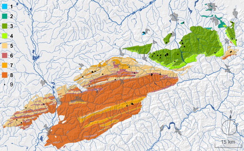
Additionally, we created two graphic attachments in order to supplement the final map. A simplified geological map () was prepared according to a geological map at 1:500,000 scale (CitationCGS, 2014). Based on the DTM4G data, hypsometric curves for each geomorphic unit were supplemented with the positions of cave entrances. Some of the results arising from hypsometric analyses were supplemented and verified by cluster analyses calculated using PermutMatrix 1.9.3 software (CitationCaraux & Pinloche, 2005).
Figure 2. Simplified geological map. 1 – Jurassic carbonates including Štramberk Limestones; 2 – Lower Cretaceous flysch including Upper Těšín Beds of Hradiště Formation; 3 – Upper Cretaceous flysch including Mazák Formation, Godula Formation including Ostravice Sandstones, Middle and Upper Godula Beds, Pustevny Sandstones; 4 – Upper Cretaceous Istebna Formation; 5 – Upper Cretaceous/Palaeogene Soláň Formation including Ráztoka and Lukov Members; 6 – Palaeogene Beloveža Formation; 7 – Palaeogene Zlín Formation including Luhačovice and Rusava Members; 8 – Palaeogene Vsetín Member of Zlín Formation. 1–4: Silesian Nappe, 5–8: Rača Nappe. 9 – cave. Only geological units containing caves are visualised.
We combined various free data sources in order to create the Main Map. The digital terrain model from the Shuttle Radar Topography Mission (SRTM), the current version of which has 1 arc-second resolution, is sufficient for such a map scale. The DTM pixel size is ∼28 m when transformed into the Czech national coordinate system. These elevation data (visualised by a combination of colour hypsometry scale and hillshade layers) were processed using the procedures of Swiss-Style Hill-Shading (CitationBarnes, 2002; CitationJenny & Hurni, 2006). The source material related to water reaches and bodies was the DIBAVOD database containing national water management maps at 1:50,000 scale). Towns, mountains and mountain ranges including their names were adapted from state topographical maps.
3. Results and discussion
3.1. General characteristics of the pseudokarst caves
We identified 130 pseudokarst caves with a total length of 3066 m in the Czech part of the Outer Western Carpathians (). Except for four caves formed in Jurassic limestone, all other caves developed in the Cretaceous to Palaeogene flysch rocks. From the geological point of view, the pseudokarst caves were formed in 14 different rock units (). Most of the caves are found in the mountain ranges of the Czech Flysch Carpathians, that is, the Moravskoslezské Beskydy Mts, where 45 caves were identified. Out of them, 34 caves are small or short, 6 caves are medium and 5 caves are long. Three other long caves developed in the Jurassic Štramberk Limestones of the Podbeskydská pahorkatina Highland and in the Vizovická vrchovina Highland. Moreover, there are only eight medium caves occurring in six geomorphic units different from the Moravskoslezské Beskydy Mts (). Overall, there are 8 long caves, 14 medium caves, 47 short caves and 61 small caves in the area ().
Table 1. Quantity, type and size of the caves in different geomorphic units.
Additionally, the Moravskoslezské Beskydy Mts include most of the caves, with more than 1.2 m of cave passages to km2. However, the same density applies to the Jablunkovské Mezihoří Highland, which is the smallest geomorphic unit in Czechia with an area of only 56 km2.
Concerning the type of caves (), the most abundant are crevice type caves. There are 89 caves of that type, 36 of which in the Moravskoslezské Beskydy Mts. Talus type caves are the most abundant in the Vsetínské vrchy Hills (eight caves), joint type caves prevail in the Chřiby Highland (three caves). In the Javorníky Mts, the most abundant crevice type caves and talus type caves are represented equally (8).
As can be seen in the maps of the caves supplemented with the rose diagrams of measured joint sets, the crevice corridors commonly follow the main directions of joints (CitationLenart et al., 2014). The largest complex crevice type cave systems can be laterally predisposed by strike-slip faults, which may intersect the cave diagonally. Normal faults may also be observed (CitationLenart et al., 2014). The structural data are based on 258 measurements of the joints in Mraznica Cave and 1066 measurements of the joints in Cyrilka Cave, where 100 additional measurements of faults were later carried out.
The crevice type caves are also among the longest and deepest caves. Four crevice type caves reach a significant depth of at least 35 m, but most do not reach 15 m. Four out of the six deepest caves are found in the Moravskoslezské Beskydy Mts, the remaining two caves were formed in the Jurassic Štramberk Limestone.
According to the morphometric analyses (), 53 out of 130 cave entrances (41%) occur between 600 and 799 m.a.s.l. However, 24 entrances (18%) are found above 1000 m.a.s.l., all in the Moravskoslezské Beskydy Mts. Only four entrances lie below 400 m.a.s.l. The mean altitude of the cave entrances in the whole investigated area is 774 m.a.s.l., which is 341 m higher than the mean altitude in all investigated geomorphic units. The highest difference is evident in the Moravskoslezské Beskydy Mts, Slezské Beskydy Mts and Vizovická vrchovina Highland, where it is around 300 m.
Table 2. Morphometric parameters of the caves in different geomorphic units.
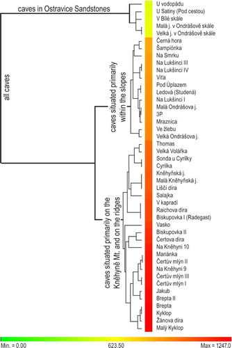
Hypsometric curves () show the distribution of cave entrances in particular geomorphic units. Most of the caves are distributed randomly in various elevation zones, which are predisposed by particular natural conditions in different areas. However, in the case of some units, the caves are distributed in clusters. In the Slezské Beskydy Mts or the Jablunkovské mezihoří Highland, this feature is probably caused by an overall small population of caves where most of them are situated in the same small area, mainly in the culmination parts of the units. A special case is that of the Moravskoslezské Beskydy Mts where a sufficient number of caves are divided into three isolated clusters. The cluster analyses () revealed the first cluster includes five caves developed in Ostravice Sandstone are a rather low elevation. The second cluster is represented by the caves situated primarily within the slopes. The third cluster is composed of caves situated primarily within the culmination area of the Kněhyně Mt., where the caves are also almost at the highest elevation in Czechia (Kyklop, Malý Kyklop and Žánova díra Caves: 1240 m.a.s.l.), and on other ridges.
Figure 3. Hypsometric curves of the geomorphic units with the distribution of cave entrances. The size of the symbol for caves is proportional to the number of caves.
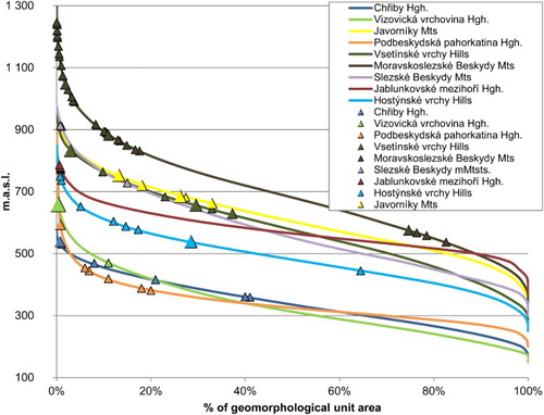
Figure 4. Cluster analysis of the elevations of individual caves situated in the Moravskoslezské Beskydy Mts. Parameters of analyses were as follows. Rows: Objective function R = 0.887; Sum of all pairwise distances of neighbouring rows (path length): S = 710.0; Linkage rule: Single linkage; Tree Seriation rule: Multiple-fragment heuristic (MF). Dissimilarity: Euclidean distance.
Concerning the slope at the cave entrances, most of the caves (45, i.e. 35%) were formed in slopes with a moderate inclination 21–25°. However, 22 caves (17%) developed in steep slopes with more than 30° inclination. 48 caves (37%) developed in slopes of southern orientation, 22 out of which are in the Moravskoslezské Beskydy Mts, where the caves dominate on east oriented slopes as well.
Ninety-three out of the 130 caves are, by their genesis, connected with the evolution of gravitational slope deformations. We split 89 of these caves into three categories according to the morphogenetic classification made by CitationUrban and Margielewski (2013) as a result of which 25 caves belong to the initial type, 17 to the intermediate type and 47 to the subsequent type. Although the population of the intermediate caves is the smallest, the sum of their length is the highest (1140 m). The overall length of the subsequent caves is 1027 m, while the overall length of the initial caves only reaches 506 m. The remaining four caves formed in the Jurassic Štramberk Limestone are not included in the analyses because the classification was developed for caves formed in flysch rocks.
Forty-seven caves in the area have recently been included in the system of targeted natural protection (20 in national natural reserves, 27 in natural monuments). Another 34 caves belong to protected areas, where the subject of protection does not cover caves. The pseudokarst caves of the Outer Western Carpathians belong to the important habitats for overwintering bats of several endangered species. As an example of their quantity, we provide the data from Cyrilka Cave on the Main Map. Note the dramatic growth of Rhinolophus hipposideros abundance.
3.2. Maps
The Main Map was prepared as a wall map of A1 paper size (841×594 mm). We used black as the background colour to symbolise the underground character of the presented features. The topographical base of the map consists of a hillshade model in greyscale combined with a green to brown continuous hypsometric scale, with the borders of the study area blended into the background black colour. Water reaches and bodies are drawn with a non-saturated dark blue colour, while towns use grey hachure areal symbols. To achieve a strong visual contrast between the background and thematic features, we used bright colours for the latter.
The Main Map, at 1:150,000 scale, shows the distribution of known pseudokarst caves within the study area. The caves are marked with point symbols with various visual variables showing the characteristics of the caves. First, the shape of the point symbol is used to distinguish the type of cave. Second, the size of the symbols represents the size of cave; four categories are used, while, another additional point symbol (placed within the main symbol) represents the position within the slope deformation. The colour of cave label represents the form of cave protection; black is used for unprotected caves, brown for caves lying within a nature reserve but not being the target feature of the reserve, and green for caves protected as a target feature within the nature reserve. Because of the spatial distribution of the caves, which are mainly clustered within certain mountain massifs, detailed insets were used for three localities and the position of some symbols had to be strongly generalised in order to avoid overlapping symbols. Nevertheless, we tried to preserve the mutual relative positions of the caves. Similarly, the placement of labels was challenging as nearly all the labels had to be placed or adjusted manually. In order to achieve clear identification of labelled features, non-traditional positioning of labels using various angles had to be applied.
As an example of the morphology of the caves, there are two detailed maps of Mraznica and Cyrilka Caves with scales of ca. 1:200 and 1:300. These maps include both the plan view and cross-sections of the caves and they are accompanied by rose diagrams of joints and faults measured in the caves. These two caves are typical and important representatives of crevice type caves in the area. The Cyrilka cave is the longest in the region, the Mraznica cave is the most recently discovered. Both the caves are mapped in detail.
The distribution of the caves within the geomorphological units is shown in a minor map (ca. 1:750,000) combining choropleth (density of cave length, m/km2) and pie chart (size according to the total number of the caves, divisions according to the types of the caves).
On the map, information on the caves is supplemented with cross-sections of the four deepest caves (1:700 scale), photographs, graph showing the results of overwintering bats between the years 1976–2015, and diagrams of the position of caves and morphometric parameters: one showing the elevation of cave entrance, slope and type of cave according to the geological units (geological units are arranged according to their age, from the oldest to youngest), the other showing the elevation and orientation of the caves.
4. Conclusion
The pseudokarst caves belong to the common geomorphic phenomena of the Outer Western Carpathians. We summarised the data of all 130 hitherto explored caves formed in Cretaceous to Palaeogene flysch rocks as well as in Jurassic limestones. We classified the caves according to their relation to the geological and geomorphic units, size, type, location, relation to the gravitational slope deformation and degree of natural protection. The highest population of caves is observed in thick-bedded flysch lithologies, especially in the Moravskoslezské Beskydy Mts.
In total, there are 8 long caves, 14 medium caves, 47 short caves and 61 small caves in the study area. The most abundant are crevice type caves (89). 41% of all the cave entrances are found between 600 and 799 m.a.s.l., whereas 18% are above 1000 m.a.s.l. The mean altitude of the cave entrances in the whole investigated area lies 341 m higher than the mean altitude of all the studied geomorphic units. 35% of the caves were formed in slopes with a moderate inclination of 21–25°, another 17% developed in steep slopes with more than 30° inclination. 37% of the caves developed in slopes of southern orientation.
Eighty-nine out of 93 caves developed in relation to gravitational slope deformations were analysed according to their morphogenesis. Twenty-five caves belong to the initial type, 17 to the intermediate type and 47 to the subsequent type. Forty-seven caves are under targeted protection, another 34 are included in protected areas where the subject of protection does not cover the caves.
The pseudokarst caves of the Outer Western Carpathians are important geomorphic features of the region with a specific genesis, evolution and morphology. Moreover, they are important as habitats for the endangered species of overwintering bats. The presented map summarises a large amount of data from various published and unpublished sources. As maps (CitationMiklín, 2012; CitationMiklín & Macháček, 2016) and other cartographic works (CitationMiklín & Lenart, 2016) can be considered ideal mediums to transfer scientific knowledge to the general public, we believe the map can be used as introductory material into the problems of pseudokarst caves.
Software
Data layers used in the creation of the main map were processed in ESRI ArcGIS (version 10.2.1) software. Detail maps of Cyrilka and Mraznica Caves were originally drawn in CorelDraw using results of field mapping; these data were imported and further adjusted in Adobe Illustrator (version CS6). Rose diagrams of the directions of joints and faults (results of terrain mapping) were created in Stereonet v. 9.3.2 software (CitationAllmendinger, Cardozo, & Fisher, 2013; CitationCardozo & Allmendinger, 2013) and further adjusted in Adobe Illustrator. Using the data obtained from the analysis in ArcGIS software, diagrams of morphometric parameters were created by means of ggplot2 plugin (CitationWickham, 2013) for R software and further adjusted in Adobe Illustrator. Partial map layers exported from ArcGIS were finalised in Adobe InDesign software (version CS6) together with, for example, pictures, map of caves and diagrams. We also used Adobe Photoshop (version CS6) for adjustments of some map layers (terrain and hillshade) and photographs.
Pseudokarst Caves of the Outer Western Carpathians, Czechia.zip
Download Zip (15.8 MB)Acknowledgements
The authors would like to thank Monika Hradecká for language editing, and Michal Břežný for assistance with the preparation of diagrams.
Disclosure statement
No potential conflict of interest was reported by the authors.
ORCID
Jan Miklín http://orcid.org/0000-0002-0125-2539
Additional information
Funding
Related Research Data
References
- Allmendinger, R. W., Cardozo, N. C., & Fisher, D. (2013). Structural geology algorithms: Vectors & tensors. Cambridge: Cambridge University Press.
- AOPK. (2016). Mapomat. Retrieved January 15, 2016, from: http://mapy.nature.cz/
- Balatka, B. (1998). Geomorphological units of the Czech Republic. Retrieved March 15, 2016, from http://geoportal.cuzk.cz/Geoprohlizec/default.aspx?wmcid=9590
- Barnes, D. (2002). Using ArcMap to enhance topographic presentation. Cartographic Perspectives, 42, 5–11.
- Baroň, I. (1997). Kobylské ďůry [Kobylské caves]. Zpravodaj okresního vlastivědného muzea ve Vsetíně, 37–42.
- Baroň, I. (2004). Hluboká svahová deformace na Kopcích u Lidečka: výsledky inventarizačního a geofyzikálního průzkumu [Deep seated gravitational deformation on the Kopce hill near Lidečko: Results of inventory and geophysical analysis]. Geol vyzk Mor Slez. v r., 2003, 82–87.
- Baroň, I., Bečkovský, D., & Míča, L. (2014). Application of infrared thermography for mapping open fractures in deep-seated rockslides and unstable cliffs. Landslides, 11, 15–27. doi:10.1007/s10346-012-0367-z
- Baroň, I., Cílek, V., & Melichar, R. (2003). Pseudokrasové jeskyně jako indikátory svahových pohybů [Pseudokarst caves as an indicators of slope movements]. Geol vyzk Mor Slez v r., 2002, 84–87.
- Baroň, I., & Dobeš, P. (2000). Výsledky speleologických výzkumů na Kopcích u Lidečka [Results of speleological research on the Kopce hill near Lidečko]. Speleofórum, 10, 5–11.
- Caraux, G., & Pinloche, S. (2005). PermutMatrix: a graphical environment to arrange gene expression profiles in optimal linear order. Bioinformatics, 21, 1280–1281. doi:10.1093/bioinformatics/bti141
- Cardozo, N., & Allmendinger, R. W. (2013). Spherical projections with OSXStereonet. Computers & Geosciences, 51, 193–205. doi:10.1016/j.cageo.2012.07.021
- CGS. (2013). Geological map 1:50,000. Retrieved February 12, 2016, from http://mapy.geology.cz/geocr_50/
- CGS. (2014). Geological map 1: 500,000. Retrieved May 18, 2016, from http://mapy.geology.cz/geovedni_mapy500/
- CUZK. (2013). Digital terrain model of the Czech Republic of the 4th generation (DMR 4G). Retrieved May 5, 2016 from http://geoportal.cuzk.cz/(S(bieq4ip4qd5zlyceotym4gob))/Default.aspx?lng=EN&mode=TextMeta&side=vyskopis&metadataID=CZ-CUZK-DMR4G-V&mapid=8&menu=301
- Četyna, B. (1966). Radhošť v minulosti a přítomnosti: Kulturně-historický přehled [Radhošť in the past and present: cultural-historical overview]. Nový Jičín: Vlastivědný ústav.
- Danišík, M., Pánek, T., Matýsek, D., Dunkl, I., & Frisch, W. (2008). Apatite fission track and (U-Th)/He dating of teschenite intrusions gives time constraints on accretionary processes and development of planation surfaces in the Outer Western Carpathians. Zeitschrift für Geomorphologie, 52, 273–289.
- Demek, J., & Mackovčin, P. (Eds.). (2006). Zeměpisný lexikon České republiky: hory a nížiny [Geographical lexicon of Czech Republic: Mountains and Lowlands]. Brno: Agentura ochrany přírody a krajiny České republiky.
- Foldyna, J. (1968). Pseudokras v goduslkých vrstvách dílčího příkrovu godulského (Moravskoslezské Beskydy) [Pseudokarst in the Godula beds of Godula rock formation (Moravian-Silesian Beskyds)]. Sborník vědeckých prací VŠB v Ostravě, řada hornicko-geologická, 14, 83–103.
- Foldyna, J., & Pavlica, J. (1968). Pseudokras masívu Lysé hory a Kněhyně [Pseudokarst of the Lysá hora Mt. and the Kněhyně Mt.]. Sborník vědeckých prací VŠB v Ostravě, řada hornicko-geologická, 14, 69–82.
- Halliday, W. R. (2007). Pseudokarst in the 21st century. Journal of Cave and Karst Studies, 69, 103–113.
- Hromas, J. (Ed.). (2009). Jeskyně [The caves]. In P. Mackovčin & M. Sedlaček (Eds.), Chráněná území České republiky [Protected landscape areas of the Czech republic]. (pp. 56–58). Praha: AOPK ČR and EkoCentrum Brno.
- Jenny, B., & Hurni, L. (2006). Swiss-style colour relief shading modulated by elevationand by exposure to illumination. The Cartographic Journal, 43, 198–207. doi:10.1179/000870406X158164
- JESO. (2016). Unified register of speleological objects. Retrieved May 1, 2016, from: http://jeso.nature.cz/
- Klimeš, J., Rowberry, M. D., Blahůt, J., Briestenský, M., Hartwich, F., Košťák, B., … Štěpančíková, P. (2012). The monitoring of slow-moving landslides and assessment of stabilisation measures using an optical–mechanical crack gauge. Landslides, 9, 407–415. doi:10.1007/s10346-011-0306-4
- Krejčí, O., Baroň, I., Bíl, M., Jurová, Z., Hubatka, F., & Kirchner, K. (2002). Slope movements in the Flysch Carpathians of Eastern Czech Republic triggered by extreme rainfalls in 1997: A case study. Physics and Chemistry of the Earth, 27, 1567–1576.
- Lenart, J. (2015). Morphological patterns of crevice-type caves in sedimentary rocks of the Outer Western Carpathians (Czech Republic). Journal of Cave and Karst Studies, 77(3), 165–176. doi:10.4311/2014ES0113
- Lenart, J., Pánek, T., & Dušek, R. (2014). Genesis, types and evolution of crevice-type caves in the Flysch Belt of the Western Carpathians (Czech republic). Geomorphology, 204, 459–476. doi:10.1016/j.geomorph.2013.08.025
- Lenart, J., Wagner, J., & Škarpich, V. (2013). Objevy rozsedlinových jeskyní ve flyši Karpat mezi roky 1997 a 2012 [Discoveries of crevice-type caves in the Flysch Carpathians between years 1997 and 2012]. Speleofórum, 32, 34–37.
- Margielewski, W., & Urban, J. (2003). Crevice-type caves as initial forms of rock landslide development in the Flysch Carpathians. Geomorphology, 54, 325–338. doi:10.1016/S0169-555X(02)00375-6
- Miklín, J. (2012). Atlas of Pálava protected landscape area. Journal of Maps, 8, 492–498. doi:10.1080/17445647.2012.749002
- Miklín, J., & Lenart, J. (2016). Visualisation of volcanic relief and processes: The Nízký Jeseník upland educational trail, Czech Republic. Journal of Maps, 12, 1104–1111. doi:10.1080/17445647.2015.1127859
- Miklín, J., & Macháček, P. (2016). Birds of Lednické rybníky Fishponds (Czech Republic). Journal of Maps. doi:10.1080/17445647.2016.1195297
- Pánek, T., & Lenart, J. (2016). Landslide landscape of the Moravskoslezské Beskydy mountains and their surroundings. In T. Pánek & J. Hradecký (Eds.), Landscapes and landforms of the Czech Republic (pp. 347–359). Berlin: Springer. doi:10.1007/978-3-319-27537-6
- Pánek, T., Margielewski, W., Tábořík, P., Urban, J., Hradecký, J., & Szura, C. (2010). Gravitationally induced caves and other discontinuities detected by 2D electrical resistivity tomography: Case studies from the polish Flysch Carpathians. Geomorphology, 123, 165–180. doi:10.1016/j.geomorph.2010.07.008
- Pánek, T., Šilhán, K., Tábořík, P., Hradecký, J., Smolková, V., Lenart, J., … Pazdur, A. (2011). Catastrophic slope failure and its origins: Case of the May 2010 Girová Mountain flow-like rockslide (Czech Republic). Geomorphology, 130, 352–364. doi:10.1016/j.geomorph.2011.04.020
- Pánek, T., Tábořík, P., & Hradecký, J. (2007). Gravitační rozpad hřbetu Čertova mlýna (Moravskoslezské Beskydy) [Gravitational break-up of the Čertův mlyn ridge (Moravskoslezské Beskydy Mts.)]. Geol. výzk. Mor. Slez. v r., 2006, 124–129.
- Pánek, T., Tábořík, P., Klimeš, J., Komárková, V., Hradecký, J., & Šťastný, M. (2011). Deep-seated gravitational slope deformations in the highest parts of the Czech Flysch Carpathians: Evolutionary model based on kinematic analysis, electrical imaging and trenching. Geomorphology, 129, 92–112. doi:10.1016/j.geomorph.2011.01.016
- Panoš, V. (2001). Karsologická a speleologická terminologie [Karsological and speleological terminology]. Žilina: Knižné centrum.
- Picha, F. J., Stráník, Z., & Krejčí, O. (2006). Geology and hydrocarbon resources of the Outer Western Carpathians and their foreland, Czech Republic. In J. Golonka & F. J. Picha (Eds.), The Carpathians and their foreland: Geology and hydrocarbon resources (pp. 49–175). Tulsa: The American Association of Petroleum Geologists.
- Tučník, D. (1953). Radhošťské jeskyně (Pukliny na Poustevnách na hoře Radhošti) [The caves of Radhošť (The fissures in the Pustevny on the Radhošť Mt.)]. Československy kras, 6, 185–186.
- Urban, J., & Margielewski, W. (2013). Types of non-karst caves in Polish Outer Carpathians – historical review and perspectives. In M. Filippi & P. Bosák (Eds.), Proceedings 16th international congress of speleology (pp. 314–319). Praha: Czech Speleological Society.
- Urban, J., Margielewski, W., Hercman, H., Žák, K., Zernitska, V., Pawlak, J., … Schejbal-Chwastek, M. (2015). Dating of speleothems in non-karst caves – methodological aspects and practical application, Polish Outer Carpathians case study. Zeitschrift fűr Geomorphologie, 59, 185–210.
- Vítek, J. (1983). Classification of pseudokarst forms in Czechoslovakia. International Journal of Speleology, 13, 1–18.
- Wagner, J., Demek, J., & Stráník, J. (1990). Jeskyně Moravskoslezských Beskyd a okolí [Caves of Moravskoslezské Beskydy mts. and its surroundings]. Praha: Česká speleologická společnost.
- Wickham, H. (2013). Ggplot2: Elegant graphics for data analysis (Use R!). New York, NY: Springer.