
ABSTRACT
We present a 1:350,000 high-resolution magnetic anomaly map of Calabria (Southern Italy), obtained by merging the results from two low-altitude aeromagnetic surveys performed in southern and northern Calabria. Magnetic anomalies of Calabria are of low intensity, and mostly range from 11 to –9 nT. Northern Calabria is characterized by positive anomalies in the Tyrrhenian margin (Coastal Chain) that turn into negative values moving eastward in the Sila Massif. Southern Calabria is characterized by slightly positive anomaly values, interrupted by a null magnetic anomaly corridor roughly corresponding to the eastern margin of the Gioia Tauro basin. Finally, anomaly values turn systematically negative in the Messina Straits. Due to the unprecedented resolution (low flying height, spatial sampling along the flight line of ∼5 m and 1–2 km flight line spacing), the new map highlights, in detail, the geometry and setting of the upper crustal features. As Calabria is one of the most seismically active regions in Italy, hit by several high-magnitude earthquakes in recent centuries, the interpretation of this new map will hopefully contribute to new insights into the crustal geological setting, location and dimension of the main seismogenic sources.
1. Introduction
Magnetic surveying is a geophysical method focused on the mapping of the magnetic field produced by rocks of the Earth’s crust. It allows to infer location, shape and depth of crustal magnetic sources and, combined with geologic information, it can yield an unprecedented geological interpretation of the target area. With respect to the measurement carried on land, airborne magnetic measurements have the advantage of being rapid, of covering areas otherwise difficult to access (e.g. rugged and/or inaccessible volcanic areas; CitationPaoletti et al., 2005, Citation2016), and of being much less disturbed by ground-level sources (both natural and anthropogenic). Aeromagnetic surveys are largely applied in subsurface exploration (ore and oil exploration), environmental and ground-water investigation, and geological mapping. Moreover, recent works from the western US, Australia, Antarctica and Southern Italy show that high-resolution magnetic surveys can provide new insights on the crustal setting, highlighting previously unrecognized upper crust fault geometry (CitationAitken & Betts, 2009; CitationBlakely et al., 2000; CitationChiappini, Ferraccioli, Bozzo, & Damaske, 2002; CitationDentith, Clark, & Featherstone, 2009; CitationGrauch, Hudson, & Minor, 2001; CitationGrauch & Hudson, 2007; CitationHudson, Grauch, & Minor, 2008; CitationMinelli et al., 2016).
Calabria (Southern Italy) is one of the most seismically active regions of Italy as witnessed by the occurrence of several destructive earthquakes (M 6–7) in recent centuries (CitationGalli, Scionti, & Spina, 2007). Although Pleistocene tectonics and fault activity in Calabria are well documented (CitationAntonioli et al., 2006, Citation2009; CitationCatalano, De Guidi, Monaco, Tortorici, & Tortorici, 2003, Citation2008; CitationCifelli, Rossetti, & Mattei, 2007; CitationFerranti et al., 2006; CitationGalli & Scionti, 2006; CitationMonaco & Tortorici, 2000; CitationWestaway, 1993), their role during destructive historical earthquakes is debated and the characteristics, location, and orientation of the causative sources are still a matter of discussion.
In this context, the contribution of new measurements, involving different techniques, can contribute to new insights into the geological setting, location and dimension of seismogenic sources of this region.
In this paper, we present a 1:350,000 high-resolution low-altitude magnetic anomaly map of Calabria. The full map has been produced by merging the magnetic map of southern Calabria, presented by CitationMinelli et al. (2016), with an unpublished survey carried out in northern Calabria.
The same area had already been investigated by both a ground-level survey (CitationChiappini et al., 2000) and an aeromagnetic survey (CitationAgip SpA Italia, 1981; re-evaluated by CitationCaratori Tontini, Stefanelli, Giori, Faggioni, & Carmisciano, 2004) that covered the entire Italian peninsula and surrounding seas. However, in both cases the resolution of the maps did not allow further understanding of the geological setting at a local scale. On the other hand, the map reported in the present paper has been performed at high resolution (spatial sampling along the flight line of ∼5 m, 1–2 km spacing between lines) and low altitude with respect to the previous surveys. In addition, the acquisition was performed in a drape mode to account for the high topographic variations of the region and to optimize the magnetic signal sampling.
2. Geological setting
Calabria is located above a subduction zone active since at least Oligocene times in a general setting of convergence between African and Eurasian plates. Since Middle-Late Miocene (Serravallian) times, extensional deformation took place in Calabria creating on-shore (Crati Valley, S. Eufemia plain, Mesima and Gioia Tauro basins) and offshore basins bounded by extensional normal faults. Extensional tectonics continuing in Plio-Pleistocene up to Present-day times constitute the main shaping factor of the Calabrian landscape. The normal faults, N–S and NE–SW striking, form a unique normal fault system running more or less continuously along the Tyrrhenian side of Calabria. Few transversal structures dissect this system. In the last 1 Ma, strong uplift rates were measured (CitationFaccenna et al., 2011). Several active faults have been recognized in the field and some of them have been inferred as responsible for destructive earthquakes (CitationCatalano et al., 2008; CitationGalli & Bosi, 2002, Citation2003; CitationGalli & Peronace, 2015; CitationMonaco & Tortorici, 2000).
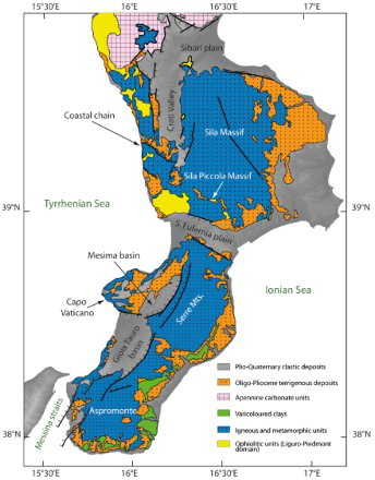
From the geological perspective (), Calabria consists of Hercynian igneous and metamorphic rocks, covered by mid–late Miocene to Pleistocene terrigenous marine successions. The Hercynian basement is inferred to tectonically overlie scattered patches of the Liguride units (Jurassic to Early Cretaceous ophiolitic units of Tethyan oceanic lithosphere), outcropping in northern Calabria along the Coastal Chain and in the Sila Piccola Massif (CitationAmodio Morelli et al., 1976; CitationBonardi, Cavazza, Perrone, & Rossi, 2001; CitationHeymes, Bouillin, Pêcher, Monié, & Compagnoni, 2008; CitationRossetti et al., 2001, Citation2004).
Figure 1. Schematic geological map of Calabria (redrawn from CitationVignaroli, Minelli, Rossetti, Balestrieri, & Faccenna, 2012).
Both scattered magnetic measurements of the Hercynian basement (CitationDe Ritis et al., 2010) and systematic magnetic analyses of the Miocene–Pleistocene marine clays (CitationCifelli et al., 2007; CitationMattei et al., 1999, Citation2002; CitationMacrì, Speranza, & Capraro, 2014) revealed very low magnetic susceptibility values in the order of 1–2 × 10⁻⁴ SI.
3. Methods
The high-resolution low-altitude aeromagnetic survey covers a large part of the Calabria Peninsula encompassing an area of about 13,000 km2, including both onshore and offshore sectors. Measurements were performed by a magnetometer towed by a helicopter. Due to the large extent of the investigated area, the survey was acquired in two stages at different times over south and north Calabria (S and N surveys hereafter).
The flight plan was designed such that the flight lines of the two surveys do not overlap and the data sampling continues in a regular way when passing from the S to N survey thus avoiding abrupt changes in resolution and the need to interpolate at the boundary. Both areas were sampled through N80° oriented aeromagnetic profiles (see lower inset of the Main Map), namely at high angle with respect to the expected trend of the regional normal faults.
The S survey, extending from the eastern side of the Peloritani Mountains (Sicily) to the Capo Vaticano promontory (Calabria), was performed during September–October 2013. Ninety-three survey lines, for a total length of more than 5000 km, were flown at 1 km line spacing. The deterioration of weather conditions along with the elevation of the Central Aspromonte Massif prevented the completion of the planned flight as the overall flight time of the contract was exceeded. Due to these circumstances, the area corresponding to the top of the Aspromonte Massif and the tie lines were left out from the survey (see lower inset of the Main Map). The results and interpretation of the S survey are reported in CitationMinelli et al. (2016).
The unpublished N survey, extending northward from the Capo Vaticano promontory, fully encompasses the Sant’ Eufemia plain and the Crati Valley and to the north ends toward the Sibari plain. The eastern boundary of the N survey area is represented by the Sila Massif. This survey was performed in September–October 2014, and consists of 94 survey lines and 2 tie lines for a total flight length of about 7200 km. In addition, practical considerations prevented completion at the planned 1 km spacing and so, in some areas, the measurements were performed at 2 km spacing.
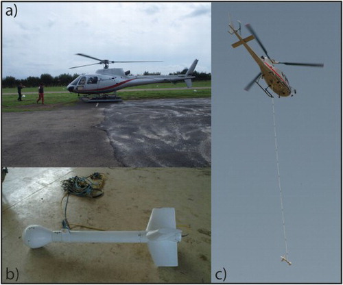
Offshore, both surveys were flown at a constant flight altitude of 1000 feet (about 270 m) above sea level, whereas in onshore areas the flight lines were performed with a terrain clearance of ca. 300 m. The magnetic measurements were performed at a sampling rate of 10 Hz through a cesium optical pumped magnetometer located in a towed aerodynamic housing suspended using a 30 m cable from the helicopter barycentric hook (). Precise positioning was achieved using a differential global positioning system receiver and the ground clearance was measured using both laser and radar altimeters. For the measurement of the time varying external magnetic field, two base stations (one for each data set) have been set in the Peloritani mountains at 38°8′ N–15°30′ E and in the Crati Valley at 39°23′ N–16°11′ E for the S and N survey, respectively (see lower inset of the Main Map). Data from the base stations have been used to correct the magnetic diurnal variation from the measured aeromagnetic data which were thus reduced to the 2013.73 and 2014.72 geomagnetic epochs for S and N surveys, respectively. Although reduced to two different geomagnetic epochs, no significant offset between the two datasets was observed. This allowed to join the two reduced datasets to be joined as a unique database for later operations such as magnetic anomaly computation, gridding and leveling. The main advantage of performing all the calibration procedures on a unique database is that the result is not affected by edge effects at the boundary between the two surveys. The reliability of this approach has been checked by comparing our result with the merged map obtained using the GridKnit™ package of the Oasis-Montaj tool, which removes offsets or trends and stitches the two grids together. We verified that the two maps, merged by using the two methodologies described above, show only negligible differences.
Figure 2. Instrumental equipment adopted during the surveys: (a) Eurocopter AS-350 B1, (b) the aerodynamic housing containing the cesium optical pumped magnetometer, and (c) the flight configuration during the acquisition surveys with the aerodynamic housing suspended through a towed cable below the helicopter.
The magnetic anomalies were obtained after the removal of the main component of the Earth’s Magnetic Field by subtracting the Geomagnetic Reference Field 11 model (IGRF11; CitationFinlay et al., 2010) from each survey point. Since the tie lines are not available for both surveys, we used micro-leveling to correct leveling errors. This numerical procedure consists in applying a directional cosine filter along the line direction and a high-pass butterworth filter at a cutoff wavelength tuned to the line spacing. The reliability of this approach has been checked by producing a N survey anomaly map (for which tie lines are available) corrected with the conventional tie line leveling and by comparing it with the micro-leveling corrected N map. The two maps show negligible differences in anomaly localization and values.
The full magnetic anomaly map has been finally reported to an altitude of 1000 m. This choice represents a compromise between the need of a map at regional scale not affected by high-frequency disturbances and the need to keep a sufficiently high resolution. The data continuation at 1000 m has been achieved through the Compudrape™ package of the Oasis-Montaj tool (CitationPaterson, Reford, & Kwan, 1990). Data are continued, through a flat surface approximation, to parallel surfaces above the measurement height and the field at the chosen level is obtained through interpolations along the vertical direction. This operation, removing the high-frequency contributions to the magnetic signal, provides a final map on which the geometry and settings of the main upper crustal features are clearly revealed.
The final magnetic anomaly map, shown on the Main Map, uses the UTM projection with the WGS84 map datum and central meridian of 15°E (zone 33 N). Data gridding has been performed using a minimum curvature algorithm, with a grid cell size of 250 m and a blanking distance of 2 km.
4. Results
The magnetic anomaly map (Main Map) shows intensity values mostly ranging between 11 and –9 nT and an mean value of –1.6 nT over the whole survey area. The overall low intensity and the wavelength of the observed magnetic anomalies are consistent with the weak magnetization of exposed crystalline and sedimentary rocks (CitationCifelli et al., 2007; CitationDe Ritis et al., 2010; CitationMacrì et al., 2014; CitationMattei et al., 1999, Citation2002). In turn, the weak magnetic anomaly values in the investigated area are in agreement with results of previous magnetic surveys of the same region (CitationAgip SpA Italia, 1981; CitationCaratori Tontini et al., 2004; CitationChiappini et al., 2000).
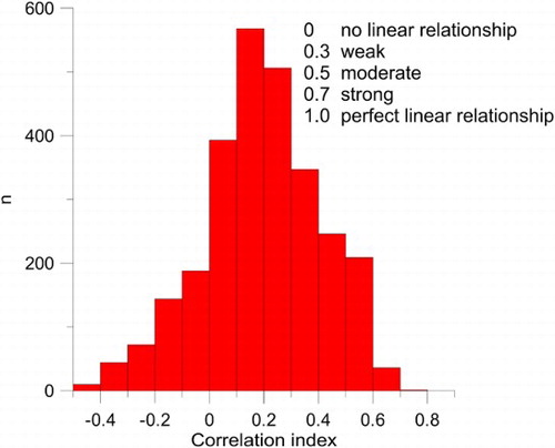
No correlation has been found between the magnetic pattern and the topography of the region. This has been verified by comparing the measured magnetic anomaly map with a synthetic field obtained by magnetizing the topography. The effect of the topography on the measured data has been quantified by calculating the correlation coefficient on circles of radius 15 km centered on the same pixel of the two maps. The histogram of the computed correlation is shown in . The presence of a peak at a low correlation (∼0.1) and the very few counts for high values of the correlation coefficient indicate that the measured anomalies are not biased by topographic effects and that they mainly arise from the geological setting of the crustal rocks at depth.
Figure 3. Histogram of the correlation between measured anomalies and a synthetic field obtained by magnetizing the topography.
In northern Calabria, the magnetic anomaly map is characterized by a 5–20 nT continuous anomaly, NNW–SSE oriented, along the Coastal Chain. Anomaly values progressively decrease moving eastward, reaching a minimum (–15 nT) at the western border of the Sila Massif (see Main Map). The positive values detected along the Tyrrhenian margin are due to the exposure, as well as to the probable occurrence at shallow depths, of ophiolites and metabasites in the Coastal Chain (CitationRossetti, Goffé, Monié, Faccenna, & Vignaroli, 2004). The higher magnetic susceptibility value of basic igneous rocks, exposed only in northern Calabria, with respect to the tectonically overlying crystalline and sedimentary rocks, could explain the occurrence of positive magnetic anomalies, reaching values of 20 nT, in this area.
The maximum anomaly value of 32 nT is found in the middle of the map at coordinates 16°30′ E–39°39′ N along an anomaly pattern trending WNW–ESE. Such high anomalies could be due to the metagabbros and metabasites exposed in the Sila Piccola Massif (CitationRossetti et al., 2001, Citation2004). This metamorphosed ophiolitic sequence, similar to that exposed in the Coastal Chain, represents an oceanic-derived complex related to the Liguride unit and exhumed along a detachment fault during post-orogenic extensional tectonics (CitationRossetti et al., 2001).
In southern Calabria, the main magnetic feature is a NE–SW elongated positive anomaly of 2–11 nT straddling both the Tyrrhenian margin and the ranges of Aspromonte and Serre, that has been interpreted by CitationMinelli et al. (2016) as being due to an unexposed ophiolitic nappe. The comparison of the magnetic anomaly map with the geological map reported in suggests that this long anomaly, crossing the entire southern Calabria, straddles the surface expression of the Serre and Cittanova faults (CitationGalli et al., 2007). The magnetic anomaly intensity gradually decreases moving from the Tyrrhenian coast to the Gioia Tauro-Mesima basins, and then rises again moving further east to the Serre-Aspromonte Mts. This anomaly pattern indicates a deepening of the buried magnetic layer moving towards the east, that is, toward the Serre and Cittanova faults (CitationGalli et al., 2007), both actively lowering the Paleozoic basement eastward and inferred as responsible of the 1783 seismic sequence (CitationGalli & Bosi, 2002; CitationJacques, Monaco, Tapponnier, Tortorici, & Winter, 2001). Further interpretation of the anomaly map of Southern Calabria is presented in CitationMinelli et al. (2016). Moving further south, the lowest magnetic anomalies are found in the Messina Straits, characterized by a remarkable negative pattern with values up to –34 nT. The magnetic minimum of the Messina Straits could be related to the lack of the ophiolitic nappe at depth, as well as to the long wavelength part of the intense dipolar anomaly of Etna volcano, located SW of the survey area (CitationD’Ajello Caracciolo et al., 2014).
We note that in southern Calabria, the main magnetic anomalies are SW–NE oriented, whereas in the northern sector the main anomaly direction is about NNW–SSE. Such trends are both consistent with the location and orientation of the main active faults of Calabria, identified through other methods (CitationCatalano et al., 2008; CitationFaccenna et al., 2011; CitationGalli & Peronace, 2015; CitationMonaco & Tortorici, 2000).
We are confident that the data continuation at an altitude of 1000 m yields reliable results even though there are 2000 m mountains in the survey area. Indeed magnetic modeling of the S survey indicates that the magnetic pattern is generated by a crustal layer located within 3 km depth (CitationMinelli et al., 2016). In the N area, the detected anomalies are plausibly due to the occurrence of ophiolitic rocks at shallow depth (CitationRossetti et al., 2004). Such evidence, together with the lack of correlation between magnetic anomalies and the topography of the region, suggests that the magnetic pattern depicted on the map is due to sources seated well below 1000 m.
The new aeromagnetic anomaly map of Calabria shown in this paper may represent a valid tool to unravel the geological and tectonic setting characterized, since the late Miocene, by the activity of several extensional faults. Since some of these faults are currently active, future interpretations of the aeromagnetic anomaly map of Calabria (complementing that of CitationMinelli et al., 2016) will hopefully support the active fault location and orientation, thus contributing to improve seismic hazard assessment.
5. Conclusions
This paper presents a new, high-resolution low-altitude aeromagnetic anomaly map of Calabria, Southern Italy. Aeromagnetic data were acquired by the Airborne Geophysics Science Team of Istituto Nazionale di Geofisica e Vulcanologia. The aeromagnetic residuals of southern Calabria previously reported by CitationMinelli et al. (2016) are merged in a unique 1:350,000 scale map with the unpublished survey data set gathered in northern Calabria. Thanks to the high resolution (spatial sampling along the flight line of ∼5 m, 1–2 km of flight line spacing), the low altitude, and the drape mode, with a terrain clearance of ca. 300 m on land in approaching relief, this work allows an unprecedented view of the magnetic features of Calabria. The occurrence of elongated positive low-intensity anomalies (trending NE–SW in Southern Calabria and NNW–SSE in Northern Calabria) is documented. The low-intensity anomaly steps already observed across the main faults of southern Calabria by CitationMinelli et al. (2016) indicate that the approach through high-resolution low-altitude aeromagnetic surveys is appropriate to detect crustal discontinuities in areas characterized by low susceptibility rocks. Indeed the subtle magnetic features shown in our map are neither visible in the previous aeromagnetic maps gathered at lower resolution (CitationCaratori Tontini et al., 2004), nor in magnetic anomaly maps obtained from ground measurements (CitationChiappini et al., 2000).
From this perspective, our map represents a valuable tool which complements the geological and geophysical evidence available in one of the most seismically active regions of the Mediterranean area. We are confident that future analyses and interpretations of this map will yield new insights on the local tectonics and seismogenic fault location.
Software
Geosoft-Oasis Montaj has been used for data processing and to produce the magnetic anomaly map. The final map has been composed by Adobe Illustrator CS2.
High-resolution aeromagnetic survey of Calabria (southern Italy.pdf
Download PDF (30.1 MB)Acknowledgements
We thank the referees P. Galli, V. Paoletti and C.P.J.M. van Elzakker for providing thoughtful reviews of the manuscript and map.
Disclosure statement
No potential conflict of interest was reported by the authors.
Additional information
Funding
Related Research Data
References
- AGIP SpA Italia. (1981). Carta Magnetica-Anomalie del Campo magnetico residuo, scala 1:500,000. San Donato Milanese, Italy.
- Aitken, A. R. A., & Betts, P. G. (2009). Multi-scale integrated structural and aeromagnetic analysis to guide tectonic models: An example from the eastern Musgrave Province, Central Australia. Tectonophysics, 476, 418–435. doi: 10.1016/j.tecto.2009.07.007
- Amodio Morelli, L., Bonardi, G., Colonna, V., Dietrich, D., Giunta, G., Ippolito, F., … Zuppetta, A. (1976). L'Arco Calabro-Peloritano nell'orogene Appenninico-Maghrebide. Memorie: Società Geologica Italiana, 17, 1–60.
- Antonioli, F., Ferranti, L., Fontana, A., Amorosi, A., Bondesan, A., Braitenberg, C., … Stocchi, P. (2009). Holocene relative sea-level changes and vertical movements along the Italian and Istrian coastlines. Quaternary International, 206, 102–133. doi: 10.1016/j.quaint.2008.11.008
- Antonioli, F., Ferranti, L., Lambeck, K., Kershaw, S., Verrubbi, V., & Dai Pra, G. (2006). Late Pleistocene to Holocene record of changing uplift rates in southern Calabria and north-eastern Sicily (Southern Italy, Central Mediterranean Sea). Tectonophysics, 422, 23–40. doi: 10.1016/j.tecto.2006.05.003
- Blakely, R. J., Wells, R. E., Tolan, T. L., Beeson, M. H., Trehu, A. M., & Liberty, L.M. (2000). New aeromagnetic data reveal large strike-slip (?) faults in the northern Willamette Valley, Oregon. Geological Society American Bulletin, 112(7), 1225–1233. doi: 10.1130/0016-7606(2000)112<1225:NADRLS>2.0.CO;2
- Bonardi, G., Cavazza, W., Perrone, V., & Rossi, S. (2001). Calabria-Peloritani Terrane and Northern Ionian Sea. In G. B. Vai & J. P. Martini (Eds.), Anatomy of an Orogen: The Apennines and the adjacent Mediterranean basins (pp. 287–306). Norwell, MA: Kluwer Academic.
- Caratori Tontini, F., Stefanelli, P., Giori, I., Faggioni, O., & Carmisciano, C. (2004). The revised aeromagnetic anomaly map of Italy. Annals of Geophysics, 47, 1547–1555.
- Catalano, S., De Guidi, G., Monaco, C., Tortorici, G., & Tortorici, L. (2003). Long-term behaviour of the late quaternary normal faults in the straits of Messina area (Calabrian Arc): Structural and morphological constraints. Quaternary International, 101–102, 81–91. doi: 10.1016/S1040-6182(02)00091-5
- Catalano, S., De Guidi, G., Romagnoli, G., Torrisi, S., Tortorici, G., & Tortorici, L. (2008). The migration of plate boundaries in SE Sicily: Influence on the large-scale kinematic model of the African promontory in Southern Italy. Tectonophysics, 449, 41–62. doi:10.1016/j.tecto.2007.12.003.
- Chiappini, M., Ferraccioli, F., Bozzo, E., & Damaske, D. (2002). Regional compilation and analysis of aeromagnetic anomalies for the transantarctic mountains – Ross Sea sector of the Antarctic. Tectonophysics, 347, 121–137. doi: 10.1016/S0040-1951(01)00241-4
- Chiappini, M., Meloni, A., Boschi, E., Faggioni, O., Beverini, N., Carmisciano, C., & Marson, I. (2000). Shaded relief total field magnetic anomaly map of Italy and surrounding marine areas at sea level. Annali de Geofisica, 43, 983–989.
- Cifelli, F., Rossetti, F., & Mattei, M. (2007). The architecture of brittle postorogenic extension: Results from an integrated structural and paleomagnetic study in north Calabria (Southern Italy). Geological Society of America, 119, 221–239. doi:10.1130/B25900.1.
- D’Ajello Caracciolo, F., Nicolosi, I., Carluccio, R., Chiappini, S., De Ritis, R., Giuntini, A., … Chiappini, M. (2014). High resolution aeromagnetic anomaly map of Mount Etna volcano, Southern Italy. Journal of Volcanology and Geothermal Research, 277, 36–40. doi: 10.1016/j.jvolgeores.2014.03.008
- Dentith, M., Clark, D., & Featherstone, W. (2009). Aeromagnetic mapping of precambrian geological structures that controlled the 1968 Meckering earthquake (Ms 6.8): Implications for intraplate seismicity in Western Australia. Tecnonophysics, 475, 544–553. doi: 10.1016/j.tecto.2009.07.001
- De Ritis, R., Dominici, R., Ventura, G., Chiappini, M., Speranza, F., De Rosa, R., … Sonnino, M. (2010). A buried volcano in the Calabrian Arc (Italy) revealed by high-resolution aeromagnetic data. Journal of Geophysical Research, 115, B11101. doi: 10.1029/2009JB007171
- Faccenna, C., Molin, P., Orecchio, B., Olivetti, V., Bellier, O., Funiciello, F., … Billi, A. (2011). Topography of the Calabria subduction zone (Southern Italy): Clues for the origin of Mt. Etna. Tectonics, 30. doi:10.1029/2010TC002694.
- Ferranti, L., Antonioli, F., Mauz, B., Amorosi, A., Dai Pra, G., Mastronuzzi, G., … Verrubbi, V. (2006). Markers of the last interglacial sea level high stand along the coast of Italy: Tectonic implications. Quaternary International, 145–146, 30–54. doi: 10.1016/j.quaint.2005.07.009
- Finlay, C. C., Maus, S., Beggan, C. D., Hamoudi, M., Lowes, F. J., Olsen, N., & Thébault, E. (2010). Evaluation of candidate geomagnetic field models for IGRF-11. Earth Planet Space, 62, 787–804. doi: 10.5047/eps.2010.11.005
- Galli, P., & Bosi, V. (2002). Paleoseismology along the Cittanova fault. Implications for seismotectonics and earthquake recurrence in Calabria (Southern Italy). Journal of Geophysical Research, 107(B3). doi:10.1029/2001JB000234.
- Galli, P., & Bosi, V. (2003). Catastrophic 1638 earthquakes in Calabria (Southern Italy): New insight from paleoseismological investigation. Journal of Geophysical Research, 108(B1). doi:10.1029/2002JB01713.
- Galli, P., & Scionti, V. (2006). Two unknown M > 6 historical earthquakes revealed by palaeoseismological and archival researches in eastern Calabria (Southern Italy): Seismotectonic implications. Terra Nova, 18, 44–49. doi:10.1111/j.1365-3121.2005.00658.x.
- Galli, P., Scionti, V., & Spina, V. (2007). New paleoseismic data from the lakes and serre faults (Calabria, Southern Italy). Seismotectonic implication. Bollettino della Società geologica italiana, 126, 347–364.
- Galli, P. A. C., & Peronace, E. (2015). Low slip rates and multimillennial return times for Mw 7 earthquake faults in southern Calabria (Italy). Geophysical Research Letters, 42, 5258–5265. doi:10.1002/2015GL064062.
- Grauch, V. J. S., & Hudson, M. R. (2007). Guides to understanding the aeromagnetic expression of faults in sedimentary basins: Lessons learned from the central Rio Grande rift, New Mexico. Geosphere, 3(6), 596–623. doi:10.1130/GES00128.1.
- Grauch, V. J. S., Hudson, M. R., & Minor, S. A. (2001). Aeromagnetic expression of faults that offset basin fill, Albuquerque basin, New Mexico. Geophysics, 66(3), 707–720. doi: 10.1190/1.1444961
- Heymes, T., Bouillin, J. P., Pêcher, A., Monié, P., & Compagnoni, R. (2008). Middle Oligocene extension in the Mediterranean Calabro–Peloritan belt (Southern Italy): Insights from the aspromonte nappes-pile. Tectonics, 27, TC2006. doi:10.1029/2007TC002157.
- Hudson, M. R., Grauch, V. J. S., & Minor, S. A. (2008). Rock magnetic characterization of faulted sediments with associated magnetic anomalies in the Albuquerque basin, Rio Grande rift, New Mexico. Geological Society of America Bulletin, 120(5–6), 641–658. doi: 10.1130/B26213.1
- Jacques, E., Monaco, C., Tapponnier, P., Tortorici, L., & Winter, T. (2001). Faulting and earthquake triggering during the 1783 Calabria seismic sequence. Geophysical Journal International, 147, 499–516. doi: 10.1046/j.0956-540x.2001.01518.x
- Macrì, P., Speranza, F., & Capraro, L. (2014). Magnetic fabric of Plio-Pleistocene sediments from the Crotone fore-arc basin: Insights on the recent tectonic evolution of the Calabrian Arc (Italy). Journal of Geodynamics, 81, 67–79. doi: 10.1016/j.jog.2014.07.002
- Mattei, M., Cipollari, P., Cosentino, D., Argentieri, A., Rossetti, F., & Speranza, F. (2002). The Miocene tectonic evolution of the Southern Tyrrhenian Sea: Stratigraphy, structural and paleomagnetic data from the on-shore Amantea basin (Calabrian Arc, Italy). Basin Research, 14, 147–168. doi: 10.1046/j.1365-2117.2002.00173.x
- Mattei, M., Speranza, F., Argenteri, A., Rossetti, F., Sagnotti, L., & Funiciello, R. (1999). Extensional tectonics in the Amantea basin (Calabria, Italy): A comparison between structural and magnetic anisotropy data. Tectonophysics, 307, 33–49. doi: 10.1016/S0040-1951(99)00117-1
- Minelli, L., Vecchio, A., Speranza, F., Nicolosi, I., D’Ajello Caracciolo, F., Chiappini, S., … Chiappini, M. (2016). Aeromagnetic investigation of southern Calabria and the Messina Straits (Italy): Tracking seismogenic sources of 1783 and 1908 earthquakes. Journal of Geophysical Research: Solid Earth, 121, 1297–1315. doi:10.1002/2015JB012305.
- Monaco, C., & Tortorici, L. (2000). Active faulting in the Calabrian arc and eastern Sicily. J. Geodyn., 29, 407–424. doi: 10.1016/S0264-3707(99)00052-6
- Paoletti, V., Gruber, S., Varley, N., D'Antonio, M., Supper, R., & Motschka, K. (2016). Insights into the structure and surface geology of Isla Socorro, Mexico from airborne magnetic and gamma-ray surveys. Surveys in Geophysics, 37, 601–623. doi:10.1007/s10712-015-9352-0.
- Paoletti, V., Supper, R., Chiappini, M., Fedi, M., Florio, G., & Rapolla, A. (2005). Aeromagnetic survey of the Somma-Vesuvius volcanic area. Annals of Geophysics, 48(2), 199–213.
- Paterson, N., Reford, S. W., & Kwan, K. C. H. (1990). Continuation of magnetic data between arbitrary surfaces: Advances and applications. Proceedings of the Society of Exploration Geophysicists, Sixtieth Annual International Meeting, San Francisco, Expanded Abstracts, pp. 666–669.
- Rossetti, F., Faccenna, C., Goffeé, B., Monié, P., Argentieri, A., Funiciello, R., & Mattei, M. (2001). Alpine structural and metamorphic signature of the Sila Piccola Massif Nappe stack (Calabria, Italy): Insights for the tectonic evolution of the calabrian Arc. Tectonics, 20, 112–133. doi: 10.1029/2000TC900027
- Rossetti, F., Goffé, B., Monié, P., Faccenna, C., & Vignaroli, G. (2004). Alpine orogenic P-T-t-deformation history of the Catena Costiera area and surrounding regions (Calabrian Arc, Southern Italy): The nappe edifice of north Calabria revised with insights on the Tyrrhenian-Apennine system formation. Tectonics, 23. doi:10.1029/2003TC001560.
- Vignaroli, G., Minelli, L., Rossetti, F., Balestrieri, M. L., & Faccenna, C. (2012). Miocene thrusting in the eastern Sila Massif: Implication for the evolution of the Calabria-Peloritani orogenic wedge (Southern Italy). Tectonophysics, 538–540, 105–119. doi:10.1016/j.tecto.2012.03.011.
- Westaway, R. (1993). Quaternary uplift of Southern Italy. Journal of Geophysical Research, 98, 21741–21772. doi: 10.1029/93JB01566