
ABSTRACT
This paper presents a geomorphological map of Mount Ararat/Ağri Daği in Eastern Anatolia (Turkey). Mount Ararat/Ağri Daği is a volcanic complex covered by a unique ice cap in the Near East. The massif is the result of multiple volcanic phases, and present day landforms are the result of subsequent and overlapping glacial, periglacial, and slope processes. The geomorphological mapping of Mount Ararat/Ağri Daği was firstly performed on the basis of desktop studies, by applying remote-sensing investigations using high-resolution satellite imagery (PLEIADES and SPOT images). A preliminary draft of the map was crosschecked and validated in the field as part of an interdisciplinary campaign carried out in the 2014 summer season. All the collected data suggest that the Mount Ararat/Ağri Daği glaciation played a crucial role in the evolution of the landscape and that even today glaciers are significant features in this area. Currently, ice bodies cover 7.28 km2 and include peculiar glacier types. Among these are three well-developed debris-covered glaciers, flowing down along the flanks of the volcano.
1. Introduction
Mount Ararat/Ağri Daği is an ice-capped dormant compound volcano (according to the classification of Citationde Silva & Lindsay, 2015) and represents one of the most important glacierized areas in the Near East (CitationWilliams & Ferrigno, 1991), representing a significant water resource for the surrounding land (CitationSarıkaya, 2012). It is located in Eastern Anatolia (Turkey), near the borders with Iran, Armenia, and Azerbaijan.
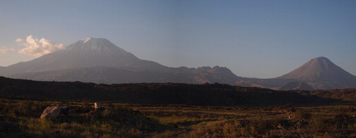
It consists of two main volcanic cones: the Greater Ararat (Buyuk Ağrı), the highest peak in Turkey and in the Armenian plateau with an elevation of 5137 m a.s.l, and the Little Ararat (Kucuk Ağri), with an elevation of 3896 m a.s.l. (). It is one of Turkey’s national parks and named ‘Ağrı Dağı Milli Parki’.
Figure 1. The Ararat/Ağri Daği volcanic complex consists of two distinct peaks: on the left, the Buyuk Ağrı (Greater Ararat, 5137 m a.s.l); on the right, the Kucuk Ağri (Lesser Ararat, 3896 m a.s.l.) (picture courtesy of R. Avanzinelli, 2014).
The mountain is known worldwide as Mt Ararat; however, none of the indigenous peoples have traditionally referred to the mountain by that name: its Turkish name is Ağrı Dağı, whereas the traditional Armenian name is Masis. The mountain has been perceived as the traditional resting place of Noah’s Ark and is also the main national symbol of Armenia. The first recorded ascent was performed in 1859 by Friedrich Parrot and Khachatur Abovian (CitationParrot, 1859).
The ice cap is well known since medieval times (CitationBerlitz, 1987), but preliminary descriptions on glaciers and glaciation were only published in the 1850s (CitationAbich, 1847; CitationParrot, 1859). In the 1950s, CitationImhof (1956) and CitationBlumenthal (1958) published quite detailed descriptions of the volcano; in spite of this general interest, few geological studies have since been undertaken (CitationKarakhanian et al., 2002; CitationNotsu, Fujitani, Ui, Matsuda, & Ercan, 1995; CitationSimkin & Siebert, 1994; CitationYilmaz, Güner, & Saroğlu, 1998). The recent availability of satellite images has permitted detailed descriptions of the ice cap and the reconstruction of its recent and past evolution (CitationÇiner, 2004; CitationKurter & Sungur, 1980; CitationKurter 1991; CitationSarıkaya, 2012; CitationSarıkaya, Çiner, & Zreda, 2011; CitationYavaşli, Tucker, & Melocik, 2015). Notwithstanding the economic, tourist, and cultural value of the region, to the best of our knowledge, no previous detailed field glaciological and geomorphological investigations have been conducted and high-resolution identification and description of the ice bodies are not available. For this reason, the main purposes of this work are (i) to produce the first 1:20,000 geomorphological map of the summit area of Mount Ararat (about 200 km2), giving particular emphasis to the glacial and periglacial landforms and (ii) to accomplish a high-resolution survey of the glaciers located here.
2. Study site
Mount Ararat is a polygenetic, compound volcano (massif). It consists of about 1150 km3 of mainly basaltic, andesitic, and dacitic lavas, and of minor dacitic and rhyolitic pyroclastic debris (CitationYilmaz et al., 1998), is the largest volcanic edifice within the region. It consists of two major volcanic cones: while Little Ararat is a steep, conical stratovolcano, Greater Ararat shows a more complex shape, derived from the building and partial destruction of a compound edifice studded by a series of basaltic andesite to andesite cinder cones and dacite lava domes (CitationSimkin & Siebert, 1994).
The two volcanoes are the surface expression of the intense magmatic activity of the collisional area of the Eastern Anatolia Accretionary Complex (CitationKeskin, 2003). The structural setting of the volcano has not been fully described. CitationDewey, Hempton, Kidd, Saroglu, and Sengor (1986) and CitationKocyigit, Yilmaz, Adamia, and Kuloshvili (2001) suggested that the Mount lies in a complex pull-apart graben related to a dextral, NW–SE system of strike-slip faults. In a more recent study, CitationKarakhanian et al., (2002) suggested that the massif is located along the NW flank of a large pull-apart basin. Conversely, CitationYilmaz et al. (1998) proposed that the Ararat/Ağri Daği volcano is developing along an extension zone formed between two en echelon segments of a sinistral strike-slip fault system. Numerous parasitic cones and lava domes have been built by flank eruptions along a horsetail splay fault system cutting through the two main edifices, (CitationKarakhanian et al., 2002), with most of these peripheral vents being distributed on the southern flanks of Greater Ararat.
The period of the last activity phase is not completely clear. Volcanic activity is documented for the Late Pleistocene (CitationNotsu et al., 1995); in particular, the dating of the youngest lavas gives an age of ca. 20,000 years BP (CitationYilmaz et al., 1998). A more recent phase of activity dates back to the 5th millennium BP (CitationSimkin & Siebert, 1994; CitationKarakhanian et al., 2002). Finally, a phreatic explosion associated with the possible generation of a pyroclastic flow (or a landslide-generated debris flow) occurred in 1840 from a radial fissure on the upper north flank of Mount Ararat, (Ahora Gorge; CitationKarakhanian et al., 2002) possibly associated with a regional earthquake of magnitude 7.4 that caused severe damage and numerous casualties. Up to 10,000 people in the Mount Ararat region died in the earthquake, including 1900 villagers in the village of Akory who were killed by a gigantic landslide and subsequent debris flow (see CitationHaroutiunian, 2005; CitationKarakhanian et al., 2002, Citation2004).
CitationYilmaz et al. (1998) produced the first simplified geological map of the area, recognizing four major stages of the volcanic evolution: a pre-cone phase, a cone-building phase, a climatic phase, and a flank eruption phase. The first period was characterized by the extrusion of a few basaltic lava flows and by a series of large pyroclastic eruptions, erupted from NNW–SSE trending extensional fissures. In the second stage, volcanic activity was concentrated in a smaller area, building the nucleus of Greater Ararat; in this phase the activity was characterized by lava and pyroclastic flows of andesitic and dacitic composition, which built the basal part of the present edifice. In the climatic phase, extended flows of andesitic and basaltic lavas were released both from central vents and from fissures along the flanks of the volcano, building the present peak of Greater Ararat above the pre-existing volcanic pile. The cone of Little Ararat possibly started to grow during this phase. In the last stage of evolution, a number of parasitic cones, domes and eruptive fractures developed on the flanks of Mount Ararat possibly along the N–S-trending horsetail splay fault system described by CitationKarakhanian et al., (2002). The field survey generally confirmed the predominance of effusive products (lava flows, lava coulees) and associated structures over pyroclastic products. The general rubbly appearance of the volcanic deposits is in fact mainly related to the blocky nature of the surface morphology of the main lava flows, characterized by surfaces completely covered by decimetric to metric, poorly vesicular blocks, and by extended, sometimes dozens of meters thick, clastic lateral and frontal levees.
The climate of this area is semi-arid; it is greatly influenced by the continental effect of the Anatolian plateau and it shows a great variability of temperature and rainfall regimes throughout the year. The average annual precipitation (1970–2006) at Dogubeyazıt (20 km southwest of the study area, 1725 m a.s.l.) is 326 mm (CitationSarikaya, 2012), although the actual precipitation amount in the area is probably slightly higher, due to the orographic effect. The mean annual air temperature at Dogubeyazıt is ca. 9°C, with a summer average of 21°C and a winter average around −3.5°C (CitationSarikaya, 2012). The assessment of long-term (1970–2009) climate trends in the region reveal a general increase in measured air temperatures over the last three decades, but no significant change in precipitation (CitationSarikaya, 2012).
3. Previous geomorphological and glaciological studies
Very few field data on the glaciation of Mount Ararat/Ağri Daği are available. The first studies about local glaciers were reported by CitationImhof (1956) and CitationBlumenthal (1958). These authors observed that there were 11 outlet glaciers emerging from a summit ice cap that covered about 10 km2; these results are in accordance with the findings of CitationHughes (2014). At that time, it was found that the present glaciers on the summit of Ararat extended as low as 3900 and 4200 m a.s.l. on the north and south-facing slopes, respectively. A more detailed quantification of the glacierized area was proposed by CitationKurter (1991) on the basis of Landsat satellite imagery interpretation. Moreover, CitationSarıkaya (2012) and CitationSarikaya and Tekeli (2014), in the remote-sensing-based inventory of Turkish glaciers, analyzed the recession of the Mount Ararat/Ağri Daği’s ice cap, highlighting that the total surface area has diminished from 7.98 ± 0.80 km2 in 1976 to 5.66 ± 0.57 km2 in 2011. These values are in agreement with data discussed by CitationYavaşli et al. (2015).
Regarding glacial and periglacial landforms, the only available study is that of CitationBlumenthal (1958), reported by CitationÇiner (2004), who estimated a Pleistocene snow line at ca. 3000 m a.s.l.; this would result in an ice cap of ca. 100 km2. However, this author did not report any clear evidence of glacial deposits along the flanks of the volcano, due to the absence of confining ridges to control glaciers, an insufficient debris load of the ice tongues to build moraine, and burial of glacial landforms under subsequent basalt flows. Only CitationBirman (1968) reported the observation of possible glacial deposits at an altitude of ca. 300 m below the 1958 glacier snout. He found two moraines, derived from valley glaciers of Pleistocene (possibly last glacial maximum (LGM) in age) down-valley from Lake Balik Golu. The higher moraine was found at an altitude of about 2200 m a.s.l. and the lower one at about 1800 m. The lower moraine occurs about 15 km downstream from Lake Balik Golu. Both moraines are about 30 m high (CitationBirman, 1968). If we take into consideration evidence of local and regional glacial advances in the Pleistocene, few studies describe the extent of glaciers on the Mount Ararat/Ağri Daği. CitationÇiner (2004), CitationSarikaya et al. (2011), CitationSarikaya and Çiner (2014), and CitationAkçar et al. (2015) reported evidence for wide Pleistocene glaciations in the Taurus Mountains, on the northern-facing slopes of the Eastern Black Sea Mountains, on the Mounts Erciyes and Süphan, and on Mount Ararat/Ağri Daği; for the LGM they identified a mean snow line altitude at ca. 2500 m a.s.l. in each locality, a part of the Mount Ararat/Ağri Daği, where it is located at ca. 3000 m a.s.l. No data on glacier extent is available for the cold phases preceding the LGM; this fact is in marked contrast with evidence from other Mediterranean regions (Greece, the Balkans, central and southern Italy, Iberia, and the Atlas). CitationHughes and Woodard (2016) interpreted this as consequence of drier climatic conditions in the Mid-Pleistocene cold stages than in the LGM, possibly related to an inability of the westerly sourced depressions to penetrate with significant effects into the far eastern Mediterranean.
4. Methods
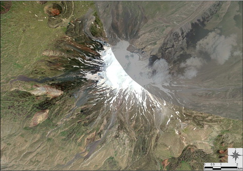
To map the main geomorphological features of Mount Ararat/Ağri Daği, we coupled remote-sensing investigations with field observations, these latter performed as part of the Ararat 2014 Expedition, coordinated by the Scientific Committee of the Italian Alpine Club (CAI). In this paper, we have mostly considered the glacial and periglacial, water-related, and gravitative landforms. Concerning the volcanic landscape, we have considered only the main features, as complete geomorphological mapping of the volcano would require an extensive and detailed field survey and radiometric dating and petrographic characterization of each lava flow. Consequently, we have classified the bedrock as undifferentiated basalt flow, and performed a more detailed description of the other geomorphological units. Exceptions to this are some volcanic units characterized by the presence of poorly eroded, clear, prominent morphologies associated with lava flows (block lava flow, lava coulees, and marginal levees) and to lava emission (domes, scoria cones, and emission vents) mainly distributed on the southern flanks of Greater Ararat. The field survey of landscape features was not possible on the North Eastern flank of the volcano (i.e. along the Ahora Gorge, near the Armenian boundary) due to governmental restrictions to this area (for further details on the area surveyed, see ). The map has been prepared at 1:20,000 scale, in order to include the whole area of Greater Ararat, ranging from ca. 2000 m a.s.l. to the summit (5137 m a.s.l.).
Figure 2. Satellite imagery (Google Earth™) of the Mount Ararat/Ağri Daği, indicating the area directly surveyed in the field. The shadowed area was not investigated due to the restricted access policy operated by the Turkish government.
As commonly attested in arid and semi-arid regions (CitationZerboni, Perego, & Cremaschi, 2015), due to the almost complete absence of arboreal vegetation and with a scarce herbaceous coverage restricted to lower elevations, the morphological features can be investigated using satellite images in the visible spectrum. High-resolution images are the most suitable for recognizing and mapping geomorphological units: we chose to detect landforms on PLEIADES (spatial resolution: 0.5 m), SPOT 7 (1.5 m), and Google Earth™ (∼2 m) imagery. Our geomorphological analyses also took advantage of the use of digital elevation models (DEMs), which allowed better evaluation of both complexity and geometry of the landscape and the computation of 100 m spaced contour lines (vertical interval). We used ASTER Global DEM (30 m spatial resolution) for a general analysis of the area and a SPOT7 DEM (3 m spatial resolution) for detailed analysis of the glacierized areas.
To assess the potential error affecting the mapping of glacier limits, we applied the method developed by CitationVögtle and Schilling (1999) and recently proposed, among the others, for Alpine (CitationDiolaiuti, Bocchiola, D’Agata, & Smiraglia, 2012; CitationDiolaiuti, Bocchiola, Vagliasindi, D’Agata, & Smiraglia, 2012; CitationSmiraglia et al., 2015) and Karakoram glaciers (CitationMinora et al., 2016). The area precision for each glacier was evaluated by buffering the glacier perimeter using an area of uncertainty as half the resolution of the image pixel (in our case ca. 2 m). The precision of the whole glacier coverage was assessed by taking the root of the squared sum of all the buffer areas. Thanks to the high resolution of satellite imagery and accurate manual mapping, glacier area data featured an error <±1%. Exceptions occur in the case of debris-covered glaciers (CitationKirkbride, 2011; CitationSmiraglia & Diolaiuti, 2011). The presence of supraglacial debris, in fact, makes glacier mapping more difficult and increases uncertainty in detecting and mapping glacier limits. In such conditions, the calculated data featured an error <±10% (CitationSmiraglia et al., 2015). To reduce the error, we also considered the glacier outlines acquired by differential global positioning system devices in the field during the 2014 mission.
The toponyms applied in this paper and on the map are those commonly used by the people living in the region and are derived from their local tradition; some other terms were reported in CitationBlumenthal (1958) to identify some areas. Unfortunately, an official topographic map of the region is not available. The legend adopted on the geomorphological map mostly relies on the guidelines proposed by the Italian Environmental Agency (CitationBrancaccio et al., 1994; CitationD’Orefice & Graciotti, 2015), but some changes have been added to solve graphical problems and those related to the chosen scale.
5. Geomorphological units
5.1. Glacial and periglacial landforms and deposits
The main geomorphological features we investigated on Mount Ararat/Ağri Daği are the glacial and periglacial forms and deposits (see the Main Map). The glacierized area at the summit of the volcano () can be classified as an ice cap (CitationWilliams & Ferrigno, 1991); however, we identified four main ice bodies flowing downward from the summit plateau. One of these is a debris-free double-tongued glacier (no local name is available), located on the Western flank of the volcano. The other three ice bodies correspond to the Parrot Glacier, on the Northeast flank, the Cehemmen Glacier, which flows in Ahora Gorge along the Northeastern flank of the mountain, and the Parachute Glacier (name suggested by a local guide) on the Southwest side of the mountain, near to the main climbing path ( and ). These glaciers are characterized by a thick (i.e. from our field investigations >20 cm) debris cover, which strongly influences surface melting and ice body evolution (CitationAzzoni et al., 2016; CitationDiolaiuti, D’Agata, Meazza, Zanutta, & Smiraglia, 2009; CitationØstrem, 1959). Moreover, this thick supraglacial debris cover has historically prevented accurate mapping of the glacier boundary; in fact, without a field survey, on medium-resolution satellite imagery it is very difficult to detect the exact limits of the debris-covered tongues with respect to the rock debris nearby. Our field surveys performed in 2014 have allowed us, for the first time, to detect and map the actual debris-covered glacier snouts. Coupling remote-sensing investigations (mainly based on 2010 Google EarthTM data) with 2014 field surveys we estimated a glacier coverage of ca. 7.28 ± 0.03 km2 including 1.82 ± 0.01 km2 of debris-covered ice surface. By comparing this value with the one reported by previous authors who studied these glaciers from satellite imagery only (i.e. CitationSarıkaya, 2012; CitationYavaşli et al., 2015) we found their data was affected by general underestimation; in fact, these authors reported a glacier surface of ca. 5.66 ± 0.57 km2 in 2011, and this smaller value can be due to the incomplete detection of debris-covered ice sectors.
Figure 3. The summit ice cap of the Buyuk Ağrı from the Western Plateau. The glacier ice, during the field campaign, was covered by fresh snow and firn.
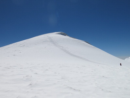
Figure 4. (a) Parachute Glacier, located near the ascent route of the peak and (b) the terminus of Parrot Glacier. In both debris-covered glaciers the debris thickness is more than 1 m and prevents the surface glacial ice melting.
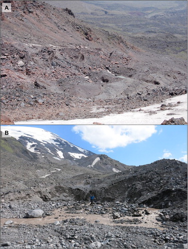
Figure 5. The upper basin of Parrot Glacier presents bare ice and a debris-covered tongue. Lateral moraine ridges are clearly visible at both sides of the glacier (indicated by the arrows).
As evident on the Main Map, the summit ice cap consists of two separated flat areas, the Western Plateau, located under the summit at about 4700 m a.s.l., and the Heyelani Plateau, located on the Northern side of the glacierized area at 4300 m a.s.l. The ice cap features a regular topography, without wide crevassed areas; in fact, crevasses are mainly located in areas that are at the junction between the ice cap and the four glacier tongues.
During our field surveys (18–28 July 2014), the glacier ice at elevations higher than 4200 m a.s.l. was observed to be covered by firn and fresh snow. The snow depth ranged from 5 to 10 cm near the Ağri Daği summit up to 100 cm on the Western Plateau. The pattern of snow coverage is be driven by wind fluxes that are mainly SW-oriented in the winter season and N–NE-oriented in summer (CitationSarikaya & Çiner, 2014). Analyzing the satellite images collected about one month later (PLEIADES acquired on the 12th August 2014) we observed the largest part of the glacier ice being snow free, thus suggesting that intense snow melting occurred after our field surveys. A non-negligible coverage of dust and fine debris is visible on the glacier ice from the satellite imagery, thus impacting on the surface albedo. Moreover, supraglacial sparse dust and fine debris strongly influences (i.e. increases) the ice melting rate (CitationAzzoni et al., 2016). The snow line showed an irregular geometry mainly due to the strong wind effects. The resulting snowfields were mainly located in depressions and cavities and newly deglaciated valleys. Their occurrence and persistence during the ablation season mostly depends on snowfall intensity and summer air temperature. The analysis of several satellite images also revealed the presence of snow fields in the warmest months, so suggesting their classification as semi-permanent ().
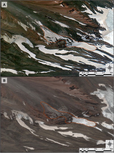
Figure 6. The snowfields of the mountain are classified as semi-permanent, due to their discontinuous presence during the summer season. For instance, we may consider the situation of this snowfield in (a) summer 2010 as from Google Earth™ satellite images, and its evolution at (b) the end of the 2014 ablation period (PLEIADES satellite imagery).
The analyses of high-resolution satellite imagery allowed the detection of an ice-related landform located along the Ahora Gorge, defined as the Cehennem Glacier. The origin of Ahora Gorge, a very deep valley, is not completely clear; on the one hand, CitationKarakhanian et al. (2002) suggest it derived from a phreatic explosion, which occurred on 2 July 1840. On the other hand, local tradition reports this eruption triggered a large landslide, which formed Ahora Gorge. Following these hypotheses, we may infer that after these catastrophic events, a glacier tongue advanced from the ice cap along Ahora Gorge. Moreover, possibly due to ongoing climate warming, the terminus area is now going to split from the ice cap, forming a long debris-covered body of dead-ice. The Cehennem Glacier along Ahora Gorge reaches the lowest elevation of ca. 2000 m a.s.l. In spite of the actual reduction phase experienced by the Ararat glaciation (CitationSarıkaya, 2012), numerous crevasses are located in the upper part of the Parrot Glacier, Cehennem Glacier, and Parachute Glacier tongues, where the steep flanks of the volcano are connected with its summit; this fact suggests the occurrence of dynamic glacial processes.
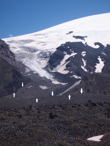
The field survey also permitted detection of the main moraine ridges along the flanks of the volcanic complex: their recognition is not always easy due to the intense slope and fluvial processes, which greatly contributed to shape the original morphology and dismantling glacial deposits (CitationPelfini & Bollati, 2014). No dating is available for these moraines, but their altitude (i.e. 3400–3800 m a.s.l.) and position is compatible with the Little Ice Age. In fact, CitationBirman (1968) identified some deposits that he dated back to this phase. As stated above, in many cases the moraine ridges are strongly eroded by active slope and fluvial processes, which has led to the complete collapse of some ridges. This has occurred mostly with frontal moraine systems, but occasionally involves lateral moraines (). On the basis of the topographic relief and the analysis of moraine locations, we detected evidence for at least eight main ice bodies that flowed along the Ararat/Ağri Daği Mount flanks, presumably during the Little Ice Age. At present, only four glaciers flow down-valley from the ice cap.
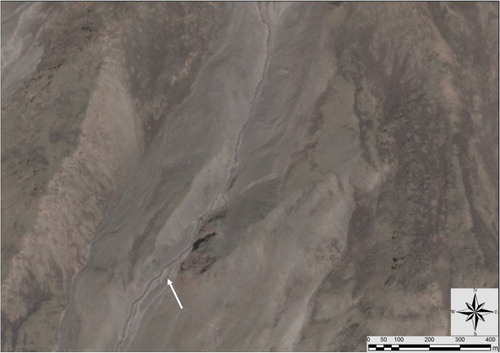
Figure 7. PLEIADES satellite imagery of a lateral moraine of one of the unnamed ice flows along the flank of Mount Ararat/Ağri Daği. The inner flanks of the moraine are cut by a glacial stream (white arrow).
5.2. Gravitative forms and deposits
Slope processes driven by gravity are active along the flanks of Mount Ararat/Ağri Daği, in particular in the Ahora Gorge area (see the Main Map). This is mainly due to the steepness of the volcano slopes, the irregular precipitation regime, the possible contribution of snow avalanches, and the instability of the unconsolidated blocky lava flows. These features are described as active slopes and, to better discriminate these areas, the principal escarpment edges are also reported. The discrimination between active debris cones and active debris flow fans is not possible due to the lack of direct field analysis: for this reason, these two features are represented in the same category. Moreover, stabilized slopes are limited due to the scarcity of vegetation that helps in fixing the unconsolidated substratum.
5.3. Water-related landforms and deposits
The hydrographic network of Mount Ararat/Ağri Daği shows a radial pattern according to the stratovolcano shape and geometry. The main streams are restricted to lower elevations, whereas ephemeral fluvial traces are numerous at higher elevations. According to the field survey, we observed that the majority of the streams feature a sporadic regime and are mainly fed by ice and snow melt. These streams alternate between temporary drought phases during cold periods and increased discharge during the ablation season; moreover, even during the night, streams showed decreased loads. Due to the permeability of the bedrock, some streams are ephemeral and the running waters infiltrate into the blocky bedrock. Fluvial activity is more evident at lower elevations (between ca. 3000 and 3500 m a.s.l.), where more gentle slopes are present and decreased water turbulence forms braided streams. Nevertheless, some active fluvial cuts, with metric-depth gullies, are present outside the area represented, where the lithology of the substratum passes from lava flows to more erodible pyroclastic deposits.
6. Conclusion
Our first overview on the main geomorphological features of Mount Ararat/Ağri Daği highlights that most of the geomorphological processes shaping the landscape are still active. At the highest elevation (i.e. >4000 m a.s.l.) ice-related processes prevail; this zone features wide glacier coverage and a large recently deglaciated area. At middle elevations (from 3000 to 4000 m a.s.l.), gravitational processes (mass wasting) and running water become the most important and evident shaping processes, whereas at the lowest elevations (<3000 m a.s.l.) water-related processes (mainly due to channelized water) act as the principal role in shaping the landscape.
Well-preserved morphologies related to volcanic activity are present particularly in the southern sector of the mapped area, possibly rejuvenated by the activity along a secondary fault system (horsetail splay fault system) during the final phase of activity of the volcanic massif.
The map presented here also highlights the importance of glaciers and ice bodies in shaping the landscape at low latitudes and in a semi-arid system. Coupling remote-sensing investigations with field survey we were able to measure a total glacier coverage of ca. 7.28 ± 0.03 km2, including 1.82 ± 0.01 km2 of debris-covered ice surface. Comparing our measurements with those reported by previous authors, mapped solely on the basis of satellite imagery (CitationSarıkaya, 2012; CitationYavaşli et al., 2015), we note that they have underestimated the true extent of glacial coverage of the volcano. Their estimation of ca. 5.66 ± 0.57 km2 (in 2011) possibly suffered the incomplete detection of debris-covered ice sectors.
In summary, this work presents the first geomorphological map of Mount Ararat/Ağri Daği and reports the first detailed quantification of the present glaciation, which relies on both field and satellite analyses. Moreover, we also provide the first description of three, previously unknown, debris-covered glaciers located in this area, which cover 25% of the total ice surface.
Software
Esri ArcGIS 8.3 was used to produce the geomorphological map of Mount Ararat (and specifically the remote-sensing analysis), development and production of the DEM, drafting of the geomorphological units, and final map layout. Google EarthTM was used for further ground controls of the limits between geomorphological units.
GEOMORPHOLOGY OF MOUNT ARARAT/AĞRI DAĞI (AĞRI DAĞI MILLI PARKI, EASTERN ANATOLIA, TURKEY).pdf
Download PDF (19.5 MB)Acknowledgements
This geomorphological map was produced as part of the activities of the 2014 ARARAT Expedition, organized by the Central Scientific Committee of the Italian Alpine Club (CSC-CAI); researchers from the University of Milano, University of Milano-Bicocca, Politecnico of Milano, University of Florence, University of Pisa, personnel from the Environmental Protection Agency (ARPA-Lombardia, Centro Nivometeorologico Bormio), and from the Medical Commission of the Italian Alpine Club who were part to the expedition. RSA, RC, EM, and CAG took part in the expedition. The authors are grateful to all the people who participated in the field campaign; in particular, we would like to acknowledge Giulia Enrione and Luigi Vanoni for medical support, Andrea Franzetti, Riccardo Avanzinelli, Simone Tommasini, Daniele Bocchiola, and Burhan Cevarun for help with field activities. The Pleiades and SPOT data were provided by the European Space Agency (ESA, project: Geomorphological mapping and recent glacier evolution of the Mount Ararat volcanic complex through SPOT and PLEIADES images; ID-32011). We thank the Editor C.R. Stokes and the reviewers J. Abraham, P. Hughes, and S. Mills for useful comments that helped to improve the clarity of the manuscript.
Disclosure statement
No potential conflict of interest was reported by the authors.
ORCID
Roberto Sergio Azzoni http://orcid.org/0000-0002-5931-486X
Andrea Zerboni http://orcid.org/0000-0002-6844-8528
Manuela Pelfini http://orcid.org/0000-0002-3258-1511
Carlo Alberto Garzonio http://orcid.org/0000-0002-2689-8192
Raffaello Cioni http://orcid.org/0000-0002-2526-9095
Claudio Smiraglia http://orcid.org/0000-0001-6635-2074
Guglielmina Adele Diolaiuti http://orcid.org/0000-0002-3883-9309
Additional information
Funding
Related Research Data
References
- Abich, G. (1847). Geological news of a journey to Ararat and particularly the collapse of the valley of Aguri in 1840. Montsberichte under die Verhandlungen der Gesseslschaft fur Erkunde zu Berlin Neue Folge. 4, 28–62.
- Akçar, N., Yavuz, V., Yesilyurt, S., Ivy-Ochs, S., Reber, R., Bayrakdar, C., … Schluchter, C. (2015). Synchronous last glacial maximum across the Anatolian peninsula 2015. Geological Society, Special Publications. doi:10.1144/SP433.7
- Azzoni, R. S., Senese, A., Zerboni, A., Maugeri, M., Smiraglia, C., & Diolaiuti, G. A. (2016). Estimating ice albedo from fine debris cover quantified by a semi-automatic method: The case study of forni glacier, Italian alps. The Cryosphere, 10, 665–679. doi: 10.5194/tc-10-665-2016
- Berlitz, C. (1987). The lost ship of Noah. New York, NY: Putnam Press. 167 pp.
- Birman, J. H. (1968). Glacial reconnaissance in Turkey. Geological Society of America Bulletin, 79(8), 1009–1026. doi: 10.1130/0016-7606(1968)79[1009:GRIT]2.0.CO;2
- Blumenthal, M. M. (1958). From Mount Ağrı to Kaçkar Mountains. Die Alpen, 34, 125–137.
- Brancaccio, L., Castiglioni, G. B., Chiarini, E., Cortemiglia, G., D’orefice, M., Dramis, F., … Pellegrini, G. B. (1994). Carta Geomorfologica d’Italia - 1:50˙000 - Guida al rilevamento, Servizio Geologico Nazionale, Quaderni serie III, 4, Istituto Poligrafico dello Stato.
- Çiner, A. (2004). Turkish glaciers and glacial deposits. In J. Ehlers & P. L. Gibbard (Eds.), Quaternary glaciations – Extent and chronology. Part I: Europe (pp. 419–129). Amsterdam: Elsevier.
- De Silva, S., & Lindsay, J. M. (2015). Chapter 15 – Primary volcanic landforms. In H. Sigurdsson (Ed.), The encyclopedia of volcanoes (2nd ed., pp. 273–297). Amsterdam: Academic.
- Dewey, J. F., Hempton, M. R., Kidd, W. S. F., Saroglu, F., & Sengor, A. M. C. (1986). Shortening of continental lithosphere: The neotectonics of Eastern Anatolia – A young collision zone. In M. P. Coward & A. C. Riea (Eds.), Collision tectonics (19 pp). London: Geological Society Special Publications.
- Diolaiuti, G., Bocchiola, D., D’Agata, C., & Smiraglia, C. (2012). Evidence of climate change impact upon glaciers’ recession within the Italian Alps: The case of Lombardy glaciers. Theoretical and Applied Climatology, 109(3–4), 429–445. doi: 10.1007/s00704-012-0589-y
- Diolaiuti, G., Bocchiola, D., Vagliasindi, M., D’Agata, C., & Smiraglia, C. (2012). The 1975–2005 glacier changes in Aosta Valley (Italy) and the relations with climate evolution. Progress in Physical Geography, 36(6), 764–785. doi: 10.1177/0309133312456413
- Diolaiuti, G., D’Agata, C., Meazza, A., Zanutta, A., & Smiraglia, C. (2009). Recent (1975–2003) changes in the Miage debris-covered glacier tongue (Mont Blanc, Italy) from analysis of aerial photos and maps. Geografia Fisica e Dinamica Quaternaria, 32, 117–127.
- D’Orefice, M., & Graciotti, R. (2015). Rilevamento geomorfologico e cartografia: realizzazione, lettura, interpretazione. Dario Flaccovio eds, 360 pp. Palermo: Dario Flaccovio.
- Haroutiunian, R. A. (2005). Катастрофическое извержение вулкана Арарат 2 июля 1840 года [ Catastrophic eruption of volcano Ararat on 2 July, 1840]. Proceedings: Earth Sciences (in Russian). Armenian National Academy of Sciences, 58(1), 27–35.
- Hughes, P. D. (2014). Little Ice Age glaciers in the Mediterranean mountains. Méditerranée, 122, 63–79. doi: 10.4000/mediterranee.7146
- Hughes, P. D., & Woodward, J. C. (2016). Quaternary glaciation in the Mediterranean mountains. Geological Society, London, Special Publications, 433. doi:10.1144/SP433.14
- Imhof, E. (1956). The Ararat. Die Alpen, 32, 1–14.
- Karakhanian, A., Djrbashian, R., Trifonov, V., Philip, H., Arakelian, S., & Avagian, A. (2002). Holocene-historical volcanism and active faults as natural risk factors for Armenia and adjacent countries. Journal of Volcanology and Geothermal Research, 113, 319–344. doi: 10.1016/S0377-0273(01)00264-5
- Karakhanian, A. S., Trifonov, V. G., Philip, H., Avagyan, A., Hessami, K., Jamali, F., … Adilkhanyan, A. (2004). Active faulting and natural hazards in Armenia, Eastern Turkey and North-Western Iran. Tectonophysics, 380, 189–219. doi:10.1016/j.tecto.2003.09.020
- Keskin, M. (2003). Magma generation by slab steepening and breakoff beneath a subduction-accretion complex: An alternative model for collision-related volcanism in Eastern Anatolia, Turkey. Geophysical Research Letters, 30, 8046. doi: 10.1029/2003GL018019
- Kirkbride, M. (2011). Debris-covered glaciers. In V. P. Singh, P. Singh, & U. K. Haritashya (Eds.), Encyclopedia of snow, ice and glaciers (pp. 190–192). Dordrecht: Springer.
- Kocyigit, A., Yilmaz, A., Adamia, S., & Kuloshvili, S. (2001). Neotectonics of East Anatolian Plateau (Turkey) and Lesser Caucasus: Implication for transition from thrusting to strike-slip faulting. Geodinamica Acta, 14, 177–195. doi: 10.1080/09853111.2001.11432443
- Kurter, A. (1991). Glaciers of Middle East and Africa-glaciers of Turkey. In R. S. Williams & J. G. Ferrigno (Eds.), Satellite image Atlas of the World. USGS Professional Paper 1386-G1.
- Kurter, A., & Sungur, K. (1980). Present glaciation in Turkey. International Association of Hydrological Sciences Publications, 126, 155–160.
- Minora, U., Bocchiola, D., D’Agata, C., Maragno, D., Mayer, C., Lambrecht, A., … Diolaiuti, G. A. (2016). Glacier area stability in the Central Karakoram National Park (Pakistan) in 2001–2010: The “Karakoram Anomaly” in the spotlight. Progress Physical Geography. doi:10.1177/0309133316643926
- Notsu, K., Fujitani, T., Ui, T., Matsuda, J., & Ercan, T. (1995). Geochemical features of collision-related volcanic rocks in central and eastern Anatolia, Turkey. Turkey Research, 64, 171–191.
- Østrem, G. (1959). Ice melting under a thin layer of moraine and the existence of ice in moraine ridges. Geografiska Annaler, 41, 228–230.
- Parrot, F. (1859). Journey to Ararat. NewYork, NY: Harper and Brothers. 389 pp.
- Pelfini, M., & Bollati, I. (2014). Landforms and geomorphosites ongoing changes: Concepts and implications for geoheritage promotion. Quaestiones Geographicae, 33(1), 131–143. doi: 10.2478/quageo-2014-0009
- Sarikaya, M. A., & Çiner, A. (2014). Late quaternary glaciations in the eastern Mediterranean. In P. D. Hughes & J. C. Woodward (Eds.), Quaternary glaciation in the Mediterranean mountains (p. 433). Amsterdam: Elsevier.
- Sarikaya, M. A., & Tekeli, A. E. (2014). Satellite inventory of glaciers in Turkey. In J. S. Kargel, G. J. Leonard, M. P. Bishop, A. Kääbm, & B. H. Raup (Eds.), Global land ice measurements from space (pp. 465–480). Berlin: Springer.
- Sarıkaya, M. A. (2012). Recession of the ice cap on Mount Ağrı (Ararat), Turkey, from 1976 to 2011 and its climatic significance. Journal of Asian Earth Sciences, 46, 190–194. doi: 10.1016/j.jseaes.2011.12.009
- Sarıkaya, M. A., Çiner, A., & Zreda, M. (2011). Quaternary glaciations of Turkey. In J. Ehlers, P. L. Gibbard, & P. D. Hughes (Eds.), Developments in quaternary science (Vol. 15, pp. 393–403). Amsterdam: Elsevier.
- Simkin, T., & Siebert, L. (1994). Volcanoes of the world (2nd ed.). Tucson: Geoscience Press in Association with the Smithsonian Institution Global Volcanism Program.
- Smiraglia, C., Azzoni, R. S., D’Agata, C., Maragno, D., Fugazza, D., & Diolaiuti, G. A. (2015). The evolution of the Italian glaciers from the previous data base to the New Italian inventory. Preliminary considerations and results. Geografia Fisica e Dinamica Quaternaria, 38(1), 79–87. doi:10.4461/GFDQ.2015.38.08
- Smiraglia, C., & Diolaiuti, G. A. (2011). Epiglacial morphologies. In V. P. Singh, P. Singh, & U. K. Haritashya (Eds.), Encyclopedia of snow, ice and glaciers (pp. 262–268). Dordrecht: Springer.
- Vogtle, T., & Schilling, K. (1999). Digitizing maps. In H. P. Bähr & T. Vögtle (Eds.), GIS for environmental monitoring (pp. 201–216). Stuttgart: Schweizerbart.
- Williams, R. S., & Ferrigno, J. G. (1991). Glaciers of the Middle East and Africa. In: R. S. Williams & J. G. Ferrigno (Eds.), Satellite image Atlas of the world. USGS Professional Paper 1386-G.
- Yavaşli, D. D., Tucker, C. J., & Melocik, K. A. (2015). Change in the glacier extent in Turkey during the Landsat Era. Remote Sensing of Environment, 163, 32–41. doi: 10.1016/j.rse.2015.03.002
- Yilmaz, Y., Güner, Y., & Saroğlu, F. (1998). Geology of the quaternary volcanic centres of the east Anatolia. Journal of Volcanology and Geothermal Research, 85, 173–210. doi: 10.1016/S0377-0273(98)00055-9
- Zerboni, A., Perego, A., & Cremaschi, M. (2015). Geomorphological map of the Tadrart Acacus Massif and the Erg Uan Kasa (Libyan central Sahara). Journal of Maps, 11(15), 772–787. doi: 10.1080/17445647.2014.955891