
ABSTRACT
This project involved the construction of a surficial (Quaternary) geologic map of part of McLean County, Illinois. The Saybrook 7.5-minute Quadrangle (scale 1:24,000) was the focus area. The quadrangle largely covers rural agricultural land, but also contains the small town of Saybrook. Multiple, major episodes of glaciation over the past 1,200,000 years have controlled the regional geologic history. The most recent (Wisconsin Episode) glaciation almost exclusively shaped the observed surficial geologic and geomorphic features in the quadrangle. Field observations, USDA soil survey data, private water well data, sparse stratigraphic borehole information, and LIDAR elevation data were used to construct the map. Computational methodologies included ACD Systems Canvas™ and Adobe Acrobat™ software. The surficial geologic map includes four lithostratigraphic units. In stratigraphic order (from oldest to youngest) are the Delavan Member, Tiskilwa Formation, Batestown Member, Lemont Formation, Henry Formation, and Cahokia Formation.
1. Introduction
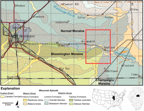
This research aims to assist in the overall understanding of the surficial geology of glacial deposits in east-central Illinois. A surficial geologic map was created to characterize and describe Quaternary-age deposits in the Saybrook Quadrangle (Main Map). This mapping is part of a broader, collective effort by the Illinois State Geological Survey to complete detailed mapping of surficial geology of Illinois at a 1:24,000 scale. This mapping provides a basis upon which other derivative geologic maps can be developed for more specific (applied) purposes, such as for the assessment of groundwater or mineral resources, or mitigation of natural hazards. The Saybrook Quadrangle has endured a complex geologic (surficial) history that included the formation of three separate, but overlapping morainal systems (Bloomington, Champaign, and Normal) in the quadrangle (), each of which marks the maximum extent and retreat of the Wisconsin Episode Laurentide Ice Sheet.
Figure 1. Surficial geology of eastern McLean County, including the Saybrook Quadrangle, which is outlined in red (modified from CitationStiff, 2000). Red stippled pattern delineates end moraines. The moraines found in the Saybrook quadrangle (Bloomington, Champaign, and Normal) are labeled.
The Saybrook Quadrangle is located in southeast McLean County, Illinois, about 25 miles east of the City of Bloomington. It occupies the area between 44°22′30″ and 44°30′00″ north latitude and 88°30′00″ and 88°37′30″ west longitude. The quadrangle is comprised of rural agricultural land, but does contain a small town that bears the same name. The area serves as the headwaters for two south-flowing major drainage systems: Sangamon River and Salt Creek. Land surface elevations in the quadrangle are some of the highest in the glaciated part of the state, ranging from 750 to 950 feet (230–290 m) above mean sea level.
2. Geologic setting
McLean County and surrounding area are located in the Bloomington Ridged Plain physiographic region of Illinois (CitationLeighton, Ekblaw, & Horberg, 1948), characterized by low, broad, morainal ridges separated by wide, flat lacustrine plans. Tills, specifically those classified to the Tiskilwa and Lemont Formations, form moraines that mark the maximum southern extent of the Wisconsin Episode ice advances in Illinois (e.g. CitationCurry, Grimley, & McKay, 2011; CitationHansel & Johnson, 1996; CitationHansel & McKay, 2010; CitationLineback, 1979; CitationWillman & Frye, 1970). In the Saybrook Quadrangle, the Bloomington Moraine is largely made up of tills of the Tiskilwa Formation, while the Normal and Champaign Moraines are composed of the Batestown Member Till. Deglacial and postglacial deposits classified to the Henry Formation (Mackinaw and Batavia facies), Cahokia Formation, and Peoria Silt are also exposed at the land surface in the quadrangle. These units include deposits of glacial outwash along the larger valleys, alluvial sand, silt and clay in the modern river valleys, and thin deposits (<3 feet or <1 m thick) of windblown silt (loess) that discontinuously covers the land surface.
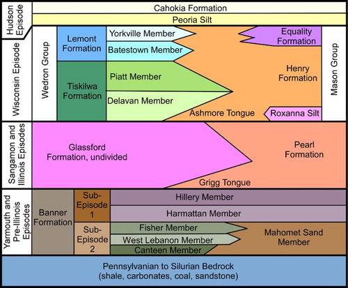
In the Saybrook Quadrangle, glacial and interglacial deposits of the Illinois and pre-Illinois Episodes are encountered in the subsurface. These primarily include tills of the Glasford and Banner Formations and outwash sand and gravel of the Pearl and Banner Formations (Kempton, Johnson, Heigold, & Cartwright, Citation1991; CitationSoller, Price, Kempton, & Berg, 1999; CitationStumpf, 2014; CitationStumpf & Atkinson, 2015). A generalized stratigraphy of Quaternary sediments in east-central Illinois, modified after CitationStumpf and Atkinson (2015), is shown in . Pennsylvanian-age bedrock underlies the unconsolidated glacial, interglacial, and postglacial sediments in the quadrangle, 200–350 feet (60–105 m) below the land surface. The bedrock geology includes sedimentary lithologies of the McLeansboro Group (Mattoon, Bond, and Shelburn-Potaka Formations), and the Carbondale Formation, mainly composed of shale, siltstone, limestone and coal (CitationKolata, 2005).
Figure 2. Generalized lithostratigraphy of Quaternary-age sediments in east-central Illinois showing the relationships of till units and intertonguing outwash, preglacial, and postglacial deposits (modified from CitationStumpf & Atkinson, 2015).
3. Methodology
The first step in creating this surficial map was to create a preliminary draft of the surficial geology based on U.S. Department of Agriculture soil survey data for McLean County (CitationCollman, Cochran, & Werner, 2004) supplied to the authors in a geographical information system (GIS) shapefile showing soil polygons from the Natural Resources Conservation Service. The shapefile, including individual soil polygons published at a scale of 1:12,000, was imported into Esri’s ArcGIS™ Version 10.2 software, and then analyzed to compile a map of soil parent materials for the Saybrook Quadrangle.
Because many of the soil types include loess in their upper horizons (A, B, and C), within 6 feet of the land surface, the parent materials classes do not include the underlying materials, which are often till. As part of this analysis, it was necessary to determine the loess thickness. A loess cover <5 feet (<1.5 m) thick was not mappable, and therefore in these areas the underlying parent material was recorded.
For much of the quadrangle, the soil parent material classes were easily translated into geology lithostratigraphic units of CitationHansel and Johnson (1996). Assigning specific lithostratigraphic units to the till was more difficult. The two different tills present in the quadrangle could not be differentiated solely from soil data. The geology logs submitted during the drilling of water wells that are archived at the Illinois State Geological Survey (ISGS) and Illinois State Water Survey were examined to help differentiate the till units, as well as determine the loess thickness. More than 100 water wells have been drilled in the Saybrook Quadrangle. In parts of the quadrangle where soil descriptions were inadequate and water well log data were unavailable or lacked detail to determine the soil parent material, the geologic unit assigned was by comparison with the neighboring parent materials and consideration of the local geology and geomorphology.
Categorized and hillshaded grids of the land surface high-resolution LIDAR elevation data obtained from the ISGS (CitationILHMP, 2012) were used to further delineate the geologic units based on the mapping of landforms and inferences made about the geomorphology. These data were helpful in delineating the extent of moraines and till plains that are coincidental with geologic map boundaries. Field verification was then completed to validate these interpretations.
The placement of contacts was adjusted following fieldwork using traditional geologic mapping methodologies. Additional information about the surface and subsurface geology was obtained from outcrops exposed along streambanks, and vertical cuts along railways and road. Most outcrops were mapped along the Sangamon River and its tributaries, where differentiations between modern alluvial deposits and glacial deposits could be made. The location of some water well locations was also verified in the field.
4. Results and conclusions
The completed surficial geologic map of Saybrook Quadrangle shows the surficial geology overlain on the USGS topographic map of the quadrangle. The geomorphology of the Saybrook Quadrangle is a result of the Wisconsin Episode glaciation events which occurred between ∼23,000 and 14,600 years before present time. The active interval of the last major glaciation is termed the Michigan Subepisode and is divided into phases (CitationCurry et al., 2011; CitationHansel & Johnson, 1996; CitationHansel & McKay, 2010) that represent glacially derived deposits of the Wedron and Mason Group, sediments found in the quadrangle and throughout the glaciated areas of the Great Lakes Region. Deposits from two phases of this subepisode, the Shelby Phase and the Putnam Phase (CitationCurry et al., 2011), are found in the quadrangle. The Shelby Phase is the second overall glacial advance of the Wisconsin Episode, but the first to reach this far south into east-central Illinois.
The Shelby Phase occurred between 22,000 and 18,000 years before present time (CitationCurry et al., 2011; CitationHansel & McKay, 2010), and is responsible for the deposition of the Tiskilwa Formation in the quadrangle. The Tiskilwa Formation is the oldest sequence of diamicton (till) of the Wedron Group. The Tiskilwa Formation can be differentiated into at least two subunits (CitationHansel & Johnson, 1996), of which the Delavan Member is mapped in the quadrangle. The Delavan Member is found at the land surface between the Bloomington and Champaign Moraines in the southern end of the quadrangle. The southern margin of the Bloomington Moraine delineates the contact between the Delevan Member and till of the undivided Tiskilwa Formation which composes the moraine. The till of the Bloomington Moraine, mapped in the southwest of the quadrangle, is largely a calcareous diamicton containing lenses of gravel, sand, silt, and clay, and is distinguishable from other tills by its distinctive pinkish gray color.
Following the Shelby Phase, and lasting until around 17,000 years ago, was the Putman Phase (CitationCurry et al., 2011; CitationHansel & McKay, 2010) glacial advance and retreat events that deposited till of the Batestown Member, Lemont Formation. The till is the predominant surficial geologic unit in the quadrangle. The Batestown Member Till composes the Normal and Champaign Moraines (), and forms the highest topographic features in the quadrangle. The till unit includes a gray, calcareous diamicton containing discontinuous lenses and beds of gravel, sand, silt, and clay. The Batestown Member Till is differentiated due to its medium texture (loam), gray color, and interbedded meltwater sediments. Glaciers during the Putnam Phase were the last advance this far south. Later glacial advances only reached the northern and eastern parts of McLean County. These glaciers deposited the Yorkville Member Till of the Lemont Formation.
Deposits of the Henry Formation, classified to the Mason Group, are found throughout the Quadrangle, especially along the Sangamon River. The Henry Formation includes stratified deposits of sand and gravel (glacial outwash) that was deposited along the margin of retreating ice lobes. Course, stratified sand and gravel are the most commonly found, and these deposits are composed of lithologically similar material found in the sand and gravel fractions of the Tiskilwa and Batestown tills. These glaciofluvial sediments were deposited in channels that served as pathways for glacial meltwater to drain from the ice margins, likely when the ice stagnated and melted back from terminal positions at the Bloomington and Normal Moraines. Paleozoic carbonate makes up the dominant pebble lithology of these deposits, although many other types of sedimentary rocks, as well as some igneous and metamorphic gravel lithologies, are present.
The youngest sediments mapped in the quadrangle are classified to the Cahokia Formation, which includes the modern sandy alluvial deposits found along rivers and streams. The alluvium includes occurrences of clay, silt, and gravel, and forms the floodplain adjacent to the Sangamon River. It may also include small deposits of slopewash at the base of steeper slopes, and material on the floodplain that has been modified by human activities.
Software
Once all of the soil polygons were satisfactorily assigned to geologic units, the map was imported into ACD Systems International Incorporated Canvas 15™ for further drafting and refinement. This included combining polygons classified to the same lithostratigraphic unit and making edits to unit boundaries. The final version of the surficial geologic map was delivered to the U.S. Geological Survey in Portable Document Format (PDF) with geospatial extensions (GeoPDF®). The geology was exported as a PDF file from Canvas, and the geology was overlain by the 2012 USGS digital topographic base map of the Saybrook IL Quadrangle (CitationUSGS, 2012) using Adobe Acrobat Pro™.
SURFICIAL GEOLOGY OF THE SAYBROOK 7.5 MINUTE QUADRANGLE, MCLEAN COUNTY, ILLINOIS, USA.pdf
Download PDF (4.3 MB)Disclosure statement
No potential conflict of interest was reported by the authors.
Additional information
Funding
Related Research Data
References
- Collman, R. D., Cochran, C. C., & Werner, S. E. (2004). Soil survey of McLean County. Illinois: United States Department of Agriculture. 421 p. Retrieved from http://www.nrcs.usda.gov/Internet/FSE_MANUSCRIPTS/illinois/IL113/0/McLean_IL.pdf
- Curry, B. B., Grimley, D. A., & McKay, E. D. (2011). Quaternary glaciations in Illinois (chapter 37). In J. Ehlers, P. L. Gibbard, & P. D. Hughes (Eds.), Quaternary glaciations – Extent and chronology a closer look. Developments in quaternary science, v. 15 (pp. 467–487). Amsterdam: Elsevier. Retrieved from http://www.sciencedirect.com/science/article/pii/B9780444534477000362
- Hansel, A. K., & Johnson, H. W. (1996). Wedron and Mason Groups: Lithostratigraphic reclassification of deposits of the Wisconsin Episode, Lake Michigan Lobe area: Illinois State Geological Survey. Bulletin 104, 116 p. Retrieved from http://hdl.handle.net/2142/43938
- Hansel, A. K., & McKay, E. D. (2010). Quaternary period. In D. R. Kolata & C. Nimz (Eds.), Geology of Illinois: Champaign, IL, University of Illinois at Urbana-Champaign, Illinois State Geological Survey (pp. 216–247). Urbana, IL: Illinois State Geological Survey.
- Illinois Height Modernization Program (ILHMP). (2012). Illinois State Geological Survey, and Illinois Department of Transportation, 2012. Illinois Height Modernization Program (ILHMP): LiDAR data: Illinois State Geological Survey. Retrieved May 10, 2016, from http://clearinghouse.isgs.illinois.edu/data/elevation/illinois-height-modernization-ilhmp-LIDAR-data
- Kempton, J. P., Johnson, W. H., Heigold, P. C., & Cartwright, K. (1991). Mahomet Bedrock Valley in east-central Illinois; topography, glacial drift stratigraphy, and hydrogeology. Geological Society of America Special Papers, 258, 91–124.
- Kolata, D. R. (2005). Bedrock geology of Illinois: Illinois State Geological Survey. Illinois Map 14, scale 1:500,000.
- Leighton, M. M., Ekblaw, G. E., & Horberg, L. (1948). Physiographic divisions of Illinois: Illinois State Geological Survey. Report of Investigations 129. 19 p. Retrieved from https://archive.org/details/physiographicdiv129leig
- Lineback, J. A. (1979). The status of the Illinoian glacial stage. In L. R. Follmer, E. D. McKay, J. A. Lineback, & D. L. Gross (Eds.), Wisconsinan, Sangamonian, and Illinoian stratigraphy in central Illinois: Illinois State Geological Survey, Guidebook 13 (pp. 69–78). Retrieved from https://archive.org/details/wisconsinansanga1994foll
- Soller, D. R., Price, S. D., Kempton, J. P., & Berg, R. C. (1999). Three-dimensional geologic maps of Quaternary sediments in east-central Illinois: United States Geological Survey. Geologic Investigations Series Map I-2669, 3 sheets. Retrieved from http://pubs.usgs.gov/imap/i-2669/
- Stiff, B. J. (2000). Surficial deposits of Illinois: Illinois State Geological Survey. Open File Series 2000-7, scale 1:500,000. Retrieved from http://isgs.illinois.edu/sites/isgs/files/maps/statewide/ofs2000-07.pdf
- Stumpf, A. J. (2014). Surficial geology of Rantoul Quadrangle, Champaign County, Illinois: Illinois State Geological Survey, USGS-STATEMAP contract report, 3 sheets, scale 1:24,000. Retrieved from https://www.isgs.illinois.edu/sites/isgs/files/maps/isgs-quads/rantoul_sg_map2.pdf
- Stumpf, A. J., & Atkinson, L. A. (2015). Geologic cross sections across the Mahomet Bedrock Valley, Champaign, Ford, McLean, Piatt, and Vermilion Counties, Illinois: Illinois State Geological Survey, Illinois Map IMAP 19, scale 1:48,000. Retrieved from http://isgs.illinois.edu/sites/isgs/files/maps/regional/mahomet_aquifer_cs_IMap19.pdf
- United States Geological Survey (USGS). (2012). 20120808, USGS US Topo 7.5-minute map for Saybrook, IL 2012: USGS – National Geospatial Technical Operations Center (NGTOC): Rolla, MO and Denver, CO. Retrieved from https://prd-tnm.s3.amazonaws.com/StagedProducts/Maps/USTopo/1/14710/5016784.pdf
- Willman, H. B., & Frye, J. C. (1970). Pleistocene stratigraphy of Illinois. Illinois State Geological Survey. Bulletin 94, 204 p. Retrieved from https://www.ideals.illinois.edu/handle/2142/43629