
 ?Mathematical formulae have been encoded as MathML and are displayed in this HTML version using MathJax in order to improve their display. Uncheck the box to turn MathJax off. This feature requires Javascript. Click on a formula to zoom.
ABSTRACT
The mapping of landforms in the Gulf of Naples is fundamental to understanding the recent evolution of this perithyrrenian basin controlled by several systems of Quaternary faults and characterised by the presence of the Campi Flegrei and Somma Vesuvius volcanoes. In this paper a 1:85,000 map of the recent evolution of the Gulf of Naples coasts is presented. This cartographic product has been obtained using a compilation of previously published geoarchaeological coastal studies integrated with new field data. The morphogenetic map suggests a differential evolution of various coastal stretches over the past 2000 years driven not only by measured vertical ground movements and eustatic sea-level rise (of 1 m) but also by eruptions of Mt. Vesuvius, in particular the Plinian eruption of 79 AD and the subsequent reworking of it’s products, as well as by the erosive action of the sea.
1. Introduction
Geoarchaeology aims to understand the human-environment relationship within an evolving environment (CitationBravi, Fuscaldo, Guarino, & Schiattarella, 2003), in order to reconstruct – in a specific area and period – the connection between the history of human settlement and culture and environmental changes (CitationBarker & Bintcliff, 1999).
Coastal geoarchaeology, in particular, can use archaeological remains as constraints on the age of ancient shorelines and on the position of ancient sea levels (CitationMorhange & Marriner, 2015; CitationVacchi et al., 2016); conversely, geological evidence provides paleogeographic and paleoenvironmental guidance useful to archaeological interpretations (CitationAnzidei et al., 2011; CitationAuriemma & Solinas, 2009). Along Mediterranean shores, numerous evidence near the coasts, such as production structures, town structures, landing places, and ports are recognisable and sometimes well-preserved. Some artefacts that are today submerged can provide important information to reconstruct the ancient coastal landscape (CitationAntonioli et al., 2007; CitationCaputo & Pieri, 1976; CitationFlemming, 1969; CitationFurlani et al., 2013; CitationLambeck, Anzidei, Antonioli, Benini, & Esposito, 2004; CitationMarriner, Morhange, & Doumet-Serhal, 2006; CitationMorhange & Pirazzoli, 2005; CitationPirazzoli, 1987; CitationRovere, Stocchi, & Vacchi, 2016; CitationScicchitano, Antonioli, Berlinghieri, Dutton, & Monaco, 2008).
Coastlines and geomorphological features such as cliffs, shorelines and sandbars, lagoons, estuaries, etc. are known to be among the most dynamic elements of the physical landscape. Such dynamics are directly related to the coastal processes that belong to endogenic factors (tectonics, isostasy, and volcanism) and surface processes (erosion, transport and sedimentation). Over the short term, seasonal and catastrophic meteo-marine events and human impacts can directly interfere with coastal changes. Over the long term, however, climate changes are the main factor influencing coastal evolution due to relative sea-level rises (CitationAnzidei et al., 2014; CitationAucelli et al., 2016c; CitationBrancaccio et al., 1991; CitationDi Paola, Aucelli, Benassai, & Rodríguez, 2014; CitationLambeck et al., 2011; CitationPappone, Alberico, Amato, Aucelli, & Di Paola, 2011; CitationPappone et al., 2012; CitationShennan, Long, & Horton, 2015,) along with volcanism, tectonic and volcano-tectonic movements (CitationAntonioli & Silenzi, 2007; CitationMorhange, Marriner, Laborel, Todesco, & Oberlin, 2006; CitationSantangelo et al., 2017).
Finally, in recent centuries, human impact on coasts and river basins have caused modifications of the sensitive Mediterranean coastal environment (CitationAmato et al., 2012, Citation2013). The interaction of coastal processes and human impacts determines the overall evolutionary trend of coastlines (CitationAlberico et al., 2012).
The Gulf of Naples is an example of the continued interaction between humans and volcanoes, as this area was densely inhabited since Greek times. As described by Strabo, the beauty of the Gulf led the construction of many villas and gardens along the whole coastal area during the Greek–Roman age. The archaeological remains of these structures are now submerged or buried by the volcanic products of Vesuvius and have inspired this research, aimed at reconstructing the Roman landscape and studying the phenomena that have influenced it’s evolution.
The purpose is to present a map representing the coastal change that has occurred since Roman times along the coasts of the Gulf of Naples, by means of geomorphological and geophysical surveys carried out at several submerged geoarchaeological sites of Roman time, taking into account the coastline position during the Last Glacial Maximum (LGM) and during the last interglacial period (MIS 5).
2. Geological and geomorphological setting
The Gulf of Naples is a NE-trending set of faults globally shaping a half graben characterised by thick volcanic units erupted from the Campi Flegrei and Vesuvius volcanoes (CitationAucelli, Brancaccio, & Cinque, in press, ; CitationMilia, Torrente, Russo, & Zuppetta, 2003). The structure of the Gulf of Naples is controlled by numerous Quaternary fault systems, NE–SW trending SE-dipping and NW–SE trending SW dipping, linked to the last stages of the opening of the Tyrrhenian Sea (CitationFedele et al., 2015; CitationMilia, 2010). Between the Middle and Upper Pleistocene, the fault systems were responsible for the development of the half-graben of the Gulf of Naples and Sorrento Peninsula fault block ridge (CitationMilia & Torrente, 2003).
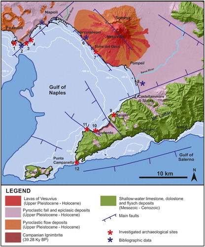
Figure 1. Geological sketchmap of Gulf of Naples.
This extensional basin covers about 1000 km2 and has the typical physiographic features of a passive continental margin, with its continental shelf slope (between −140 and −180 m of depth) and basin (CitationAiello et al., 2001; CitationMilia & Torrente, 1999).
The Gulf of Naples, characterised by both monogenic volcanoes and other volcanic and pyroclastic rocks, is bordered to the south by the carbonate succession of the Sorrento Peninsula, to the north by the Campi Flegrei volcanic area and to the east by the Vesuvian coast (; CitationBonardi, d’Argenio, & Perrone, 1988; CitationFedele et al., 2015; CitationIannace et al., 2015; CitationSantacroce & Sbrana, 2003).
The Campi Flegrei volcanic district includes Procida island and several submarine vents and monogenic volcanos (CitationPassaro et al., 2016) mostly made of pyroclastic rocks, such as Nisida island (3.92 ky BP, CitationFedele et al., 2015) in the western part of the city of Naples. The Campanian Ignimbrite (CI; 39.28 ky BP, CitationDe Vivo et al., 2001) and the Neapolitan Yellow tuff (NYT 15.3 ky BP; CitationDeino, Orsi, de Vita, & Piochi, 2004) eruptions were the two largest caldera-collapse events of Campi Flegrei volcano. These eruptions emitted large volumes of magma that mantled extensive parts of city of Naples and reached the Sorrento Peninsula. This volcanic area is still active as testified by the recent eruption of Monte Nuovo in 1538 AD (CitationDi Vito et al., in press; CitationGuidoboni & Ciuccarelli, 2011).
The Somma – Vesuvius is a 1281 m-high stratovolcano, composed of the older volcano Mt. Somma and the younger cone Mt. Vesuvius, formed from the caldera collapses produced by the three main Plinian eruptions (CitationSantacroce et al., 2008). The most famous of these eruptions is the 79 AD eruption that caused the burial of the Roman towns of Pompeii, Herculaneum, and Stabiae.
These two large volcanic complexes are separated by two alluvial plains: the Sebeto and Sarno plains, mainly formed of pyroclastic fall deposits related to upper Pleistocene to Holocene volcanic activity, and alluvial deposits.
The present morphology of the gulf basin and it’s coasts has been influenced by the interaction between tectonics, volcanism and sea-level fluctuations that have greatly contributed to it’s evolution during the Quaternary cycle (CitationBruno et al., 2003; CitationCinque et al., 1997; CitationMilia & Torrente, 1999, Citation2003, Citation2007).
3. Data and methods
The main coastal changes during the Holocene were evaluated by means of geoarchaeological surveys on several submerged archaeological sites (CitationMattei, 2016, ), conducted using two methods: integrated geophysical and morpho-bathymetric surveys by means of a marine drone (CitationGiordano, Mattei, Parente, Peluso, & Santamaria, 2016).
Figure 2. Positon of the archaeo-sites studied and zoomed maps of the navigation plan carried out at each site.
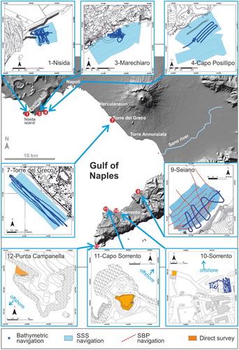
Where possible, an integrated geophysical survey has been carried out using a seismo – stratigraphic system, a side scan sonar (SSS) morphological system and single beam echosounder bathymetric system. In the other cases, we have used the MicroVeGA drone, used to carry out surveys in very shallow water (CitationGiordano, Mattei, Parente, Peluso, & Santamaria, 2015).
A seismo-stratigraphic survey (sub-bottom profiler, SBP) was undertaken off the Seiano (Sorrento Peninisula, site 9 in ) pocket beach (CitationAucelli et al., 2016a, Citation2016b). In four other cases, seismo-stratigraphic profiles previously acquired were interpreted. This acoustic system is useful for detecting thin stratifications below the seabed as well as structures or artefacts buried ((C)) by marine sediments (CitationMattei & Giordano, 2015). The D-Seismic system is high-resolution and discriminates facies in the order of 25–30 cm.
Figure 3. Archaeological targets deriving from geophysical surveys: A) SSS target of a foundation of the Termae Gymnasium at Torre del Greco, site 7; B) SSS target of a pila composing the pier at Nisida port, site 1; SBP targets of a buried pila and a rock at Seiano villa, site 9.
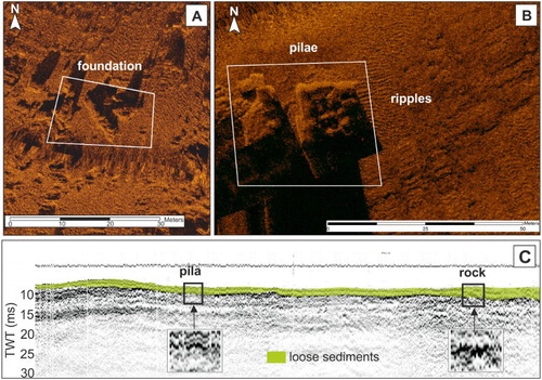
The SSS morphological system is a GeoAcoustics dual-frequency (114/410 kHz) system (MOD259) and was used for acoustic mapping of the seabed. Sonograph interpretation by means of backscatter analysis was applied to clearly discerning all significant targets, defining their nature and dimensions ((A) and (B), CitationGiordano, 2010).
The bathymetric system used at six archaeo-sites was an Omex Sonar Lite Single Beam Echo Sounder (SBES) optimised for shallow water that measures the depth at centimetric precision.
The global positioning system (GPS) receiver used in all marine surveys was a Trimble DSM 232 GPS, with decimetric precision.
Finally, the MicroVeGA drone (used at five archaeo-sites) is an unmanned surface vehicle (USV) conceived, designed and built to operate in shallow-water areas (0–20 m), where a traditional boat is poorly manoeuvrable. Such as drone, engineered by the DIST research group at the Parthenope University of Naples, is a small and ultra-light catamaran with a draught of several centimetres, suitable for performing surveys up to the shoreline (CitationGiordano et al., 2016). The payload of the MicroVeGA includes: (1) microcomputer; (2) differential GPS system and SBES; (3) integrated system for attitude control; (4) obstacle-detection system (SIROS1) with temperature control system; and (5) video acquisition system (both above and below sea level).
Moreover, at all sites studied, several direct surveys were carried out by a scuba driver in order to perform a clear interpretation of the archaeological markers and the correction of indirect data (CitationLambeck et al., 2004). lists the survey techniques adopted and the related data obtained.
Table 1. Survey techniques and related geoarchaeological data measured in the 8 archaeo-sites in .
The Main map reconstructs the coastline evolution of the Gulf of Naples over the last 2000 years, but also includes the approximate positons of the coastline during the last interglacial sea-level highstand (MIS 5) and the last glacial sea-level lowstand (LGM) as well as the maximum marine ingression in the plains during the Holocene. The geographic information has been grouped as follows:
Geological legend including the main lithostratigraphic complexes;
Type of coast including the main geomorphological types;
Archaeological landscape including the main Roman settlements, the Roman streets and the Fontis Augustei Acquaeductum;
MIS 5 sea-level markers and coastline;
LGM coastline;
Holocene main coastal changes, including the coastline position during the maximum ingression (CitationCinque, 1991; CitationIrollo, 2005), the archaeological sea-level markers, the vertical ground movements (VGM) measured at each archaeo-site (Aucelli et al., Citation2016a, Citation2016c; CitationCinque, 1991; CitationCinque & Irollo, 2008; CitationCinque et al., 2011; CitationRomano et al., 2013), the horizontal movements of the coastline over the last 2000 years, a Valentin diagram summarising the main evolutionary steps of each coastal sector.
Finally, in each coastal sector the first century AD coastline has been reconstructed. In the case of the Vesuvius coast and Sarno plain, the position of the coastline predates the 79 AD eruption.
In order to better demonstrate the evolution of the coastline over the last 2000 years, a 3D view of three sectors (Posillipo – Napoli, box I on the map; Vesuvius and Sarno plain, box II on the map; Piano di Sorrento – Sorrento Peninsula, box III on the map) have been added as boundary information. The 3D views were obtained by interpolating the Light Detection and Ranging (LIDAR) data provided by the Ministry of Environment (0–200 m asl).
3.1. Geological legend
The main lithostratigraphic complexes have been represented by means of a polygonal geographic information system (GIS) layer () and have been organised as below:
Shallow-water limestone and dolostone and flysch deposits of Mesozoic and Cenozoic age are represented in green;
Pyroclastic fall, alluvial and slope deposits of the Upper Pleistocene – Holocene time-span related to the eruptive vents are represented in violet;
Pyroclastic flows deposits of Campi Flegrei and Vesuvius volcanos (Upper Pleistocene – Holocene) are represented in orange;
CI (39.28 ky BP, CitationDe Vivo et al., 2001);
Lavas of Vesuvius related to the recent effusive activity (CitationSantacroce & Sbrana, 2003).
3.2. Type of coast
Depending on the geological characteristics, the coasts of the Gulf of Naples were divided in to five coastal stretches: Posillipo volcanic high coast, Chiaia and Sebeto coastal plains, Vesuvius volcanic high coast, Sarno coastal plain, Sorrento Peninsula high coast.
The coastal sectors, shaped over the last 2000 years by non-marine processes as river deposition, volcanic activity, tectonics and volcano-tectonic movements, are represented by a polyline GIS layer and have been divided as follows:
Low coasts, including the Chiaia – Sebeto and Sarno coastal plains;
Volcanic coasts, including the Posillipo and Vesuvius high coasts (this type represents coastal sectors of active volcanos mainly made of pyroclastic rocks and controlled by ground movements of volcanic origin);
High coasts with alternating pocket beaches, including the Sorrento Peninsula and Capri coasts.
3.3. Archaeological landscape
The anthropogenic landscape of the Roman period is represented on the map by the following layers, obtained from historical maps and reconstructions (CitationJohannowsky, 1953, Citation1985; CitationKeenan-Jones, 2010):
main Roman settlements as a polygonal layer,
Roman streets and the Fontis Augustei Acquaeductum as polyline layers.
3.4. MIS 5 seal level markers and coastline
The MIS 5 coastline position on the map (CitationSantangelo et al., 2017) coincides with the Marine Isotope Sub-stage (MIS) 5.5, dated to between 132 and 116 ky (CitationShackleton, Sánchez-Goñi, Pailler, & Lancelot, 2003). The elevation of the MIS 5 sea-level markers (CitationFerranti & Antonioli, 2007; CitationFerranti et al., 2006, Citation2010) demonstrates a general subsiding pattern in the study area during this period, induced by regional tectonics and secondarily by soil compaction, with localised exceptional vertical ground movement related to volcanic processes.
3.5. LGM coastline
The coastline position during the last glacial period (60–15 ky) was influenced not only by marine regression but also by the CI eruption (39.28 ky BP, CitationDe Vivo et al., 2001), an extreme event that strongly modified the palaeolandscape. The pyroclastic flow of this eruption mantled the whole Gulf with deposits tens of metres thick, as demonstrated by the stratigraphic record in the plains (CitationAprile, Toccaceli, & Sbrana, 2004; CitationRomano, Santo, & Voltaggio, 1994) and by seismic profiles in the offshore area (CitationMilia & Torrente, 1999). The LGM coastline positon, approximately coincides with the shelf break, between 140–180 m deep, demonstrating that the subsiding trend of the Gulf continued during this period (CitationMilia & Torrente, 2007).
3.6. Holocene main coastal changes
The results of a series of geoarchaeological surveys performed on several submerged archaeological sites was integrated with bibliographic data (Aucelli et al., Citation2016a, Citation2016c; CitationCinque, 1991; CitationCinque & Irollo, 2008; CitationRomano et al., 2013; CitationVogel & Märker, 2010), in order to increase the control points and to obtain the Holocene landscape evolution of the study area.
Non-invasive prospecting techniques have been used to investigate height underwater archaeological sites for the identification of the remains of man-made structures, as well as for a three-dimensional reconstruction of geomorphological and stratigraphic features linked to ancient positions and shapes of the coastline. All steps of the analysis were recorded within a GIS project structured in modules that managed both planning and processing data of the surveys (CitationMattei, 2010).
3.6.1. Coastline positon during the maximum ingression
The coastline positon during the maximum marine ingression related to the Holocene sea-level highstand (5.8 ky BP) was reconstructed in the coastal plain of Sebeto (CitationIrollo, 2005) and Sarno (CitationCinque, 1991), by interpreting several stratigraphic records.
3.6.2. Archaeological sea-level markers
The archaeological sea-level markers studied in each archaeo-site () is represented on the map by a point symbol, classified as pier (including the quays), fishpond, building, breakwater, and archaeo-stratigraphic markers (such as buried beachface deposits). On the left part of the map, a photo of each archaeo-marker studied with the measurement of the first century sea level was represented in a table.
Table 2. Sea-level markers studied in the 12 archaeo-sites.
3.6.3. First century AD coastline
The production of morphological data has allowed the precise evaluation of coastal evolution over the last 2000 years and the Roman coastline position (Aucelli et al., Citation2016a, Citation2016c; CitationCinque, 1991; CitationCinque & Irollo, 2008; CitationIrollo, 2005; CitationRomano et al., 2013), as well as a 3D reconstruction of the emerged and submerged landscape. This output for all archaeo-sites using the high precision bathymetric survey, was integrated with a digital terrain model of the adjacent coastal stretches obtained by processing coastal LIDAR data provided by the Italian Ministry of the Environment in March 2013. On the map, we have reconstructed the 3D morphology of three coastal sectors, derived from the LIDAR data, and the position of the Roman coastline derived from the bathymetric data.
3.6.4. Vertical ground movements
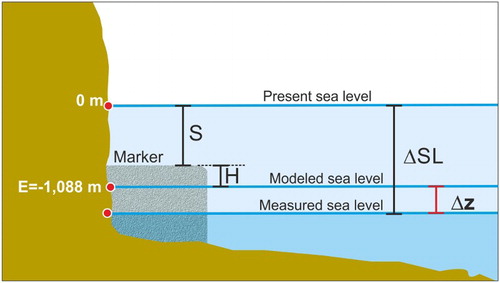
The submersion of all archaeological markers (S) was calculated by correcting the measurement taken by the SBES with respect to the tide and atmospheric pressure (CitationLeoni & Dai Pra, 1997), in order to evaluate the submersion with respect to the present mean sea level. This value was then added to the functional height (H) or depth at the time of the building (CitationAuriemma & Solinas, 2009) – in order to obtain the relative sea-level rise over the last 2000 years (ΔSL).
Finally, the vertical ground movement () affecting the archaeological site studied was calculated as:where ΔSL is the sea-level change (m) over the last 2.0 ky; E is the value (m) of the eustatic curve taken from Lambeck et al. (Citation2011: 1.088 m) in .
Figure 4. Calculation method of relative sea-level rise over the last 2000 years (ΔSL) and the VGM, both measured for each archeao-site.
On the map, the circles at the archaeological sites represent the measured VGM, the colour defines the direction and the dimension defines the amount.
3.6.5. Horizontal movements of coastline
The late Holocene evolution of each coastal sector inferred from geoarchaeological data was the target of this work. Moreover, coastline evolution over the last 2000 years was achieved by the evaluation of ΔSL, namely sea-level rise due to the eustatic effect added to sea-level oscillation due to vertical ground movement affecting each coastal stretch. In the case of a high coast, we positioned the hypothetical ancient coastline of a specific coastal stretch on the isobath corresponding to the value of ΔSL evaluated at all archaeo-sites studied in the sector, and then we evaluated the horizontal variation. In the case of a low coast, the coastline positon was obtained by interpreting published stratigraphic data or by interpreting seismic profiles (as in the case of the Seiano pocket beach).
The bathymetric measurements taken at all archaeological sites were integrated with the multibeam bathymetric map provided by Servizio Difesa Suolo – Regione Campania, CARG project.
On the map, the horizontal arrows quantify the horizontal movements of the various sectors, and the colour defines the main forcing.
3.6.6. Valentin diagram
A graphic summary of the effects of endogenous and exogenous factors on the coasts evolution is given by the Valentin Diagram (Citation1952), which consists of two graduated axes (expressing the average rates of the processes) that, crossing the zero point, become four semi-axes and define four quadrants ().
Figure 5. Schema of the octants of Valentin diagram.
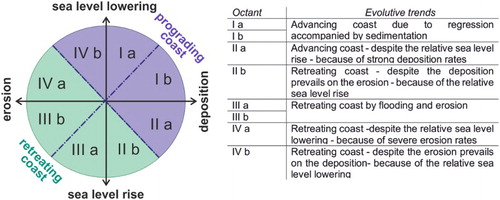
The vertical axis is the change in relative sea level, namely the algebraic sum of the absolute rate of change in the average sea level and the rhythm of VGM.
The horizontal axis is the prevailing morphodynamic trend of the coastal stretch, linked to the alternating periods of erosion and deposition.
On the map, a sketch of this diagram was constructed for each coastal sector, summarising the main steps of coastal evolution over the last 2000 years; the colour of the circles defines the age of the steps.
4. Discussion and conclusions
The landscape evolution map of the coasts of the Gulf of Naples has the aim of representing the relative sea-level changes and modification of coastal landscape that has occurred since the Roman period, by means of a geoarchaeological study of several submerged archaeological sites, but also coastline evolution between the last interglacial sea-level highstand and the last glacial sea-level lowstand. In addition, the maximum marine ingression in the two coastal plains during the Holocene has been marked with the approximate positon of the coastline at that time.
The coast of the Gulf of Naples over the last 2000 years has had a diverse evolution depending on outcropping lithology and VGM, as well as the arrival of primary or secondary pyroclastic flows on some coastal stretches, as in the case of the 79 AD eruption of Vesuvius.
In the map presented here, the evolution of the coastal landscape in each coastal sector has been reconstructed by evaluating the VGM that has occurred over the last 2000 years, of volcano-tectonic origin (connected to the activity of Campi Flegrei and the eruption of Vesuvius in 79 AD) or due to regional tectonic forcing.
The Neapolitan coastal sector has been affected by a subsiding trend that has led to the submersion of the Posillipo coastal sector because of eustasy and of regional tectonic phenomena (CitationRomano et al., 2013).
The Vesuvian coast has been greatly affected by volcano-tectonic VGM and has been strongly modified by the effects of the Plinian eruption of Vesuvius in 79 AD (CitationCinque & Irollo, 2008).
In the Sebeto and Sarno coastal plain a subsiding trend, partially due to regional tectonics and the compaction of loose sediments, was compensated by substantial clastic contributions related to the emplacement and reworking of pyroclastic products of the Vesuvius volcano (CitationIrollo, 2005; CitationVogel & Märker, 2010 and references therein).
Finally, the Sorrento Peninsula is a tectonically stable sector with submerging coasts, although some stretches of coastline have been modified by flooding following the 79 AD Vesuvius eruption (Aucelli et al., Citation2016a, Citation2016c).
We must highlight the fundamental role that the Plinian eruption of Vesuvius in 79 AD has played in the modification of the south-eastern coastal landscape of the Gulf. In fact, both pyroclastic flows, and the subsequent floods, have caused abrupt coastal advance of several hundred metres, not only in the Vesuvius coastal sector but also in some pocket beaches of the Sorrento Peninsula.
In this map we summarise these results and in particular:
The horizontal arrows quantify the horizontal movements of the various sectors, and the colour defines the main forcing.
The circles on the archaeological sites represent the measured VGM, the colour defines the direction.
The schematic Valentin diagrams summarise the main evolutionary steps of the various coastal areas, the colour of circles define the age of the steps.
In conclusion, this map by offering geological, geomorphological and archaeological data may represent a state-of-the-art for scientists working in these fields. This product is a useful cartographic tool to understand the coastal changes over the investigated time-span and related main causes. Therefore, it represents the first level of information for scientists that want to investigate the relationship between human and coastal environments in the past. It also provides much information, such as VGM and relative sea-level rise that can be used for studies on coastal trend predictions, as well as the impacts of climate change.
Software
The main data layers were created using Esri ArcGIS: lithostratigraphic complexes, coastal types, coastlines, geoarchaeological data. The Spatial Analyst extension was used to interpolate the bathymetric data and to create the shaded relief of the base map, deriving from the mosaic of 5×5 m DTM provided from Campania Region. The final layout in A1 format was produced using CorelDRAW.
Late Holocene landscape evolution of the Gulf of Naples (Italy) inferred from geoarchaeological data.pdf
Download PDF (34.2 MB)Acknowledgements
The authors sincerely thank Professor Francesco Giordano for his invaluable help during the marine surveys and interpretations of geophysical data, Dott. Mario Russo and Dott. Michele Stefanile for the archaeological interpretations. Sincere thanks are also due to Francesco Peluso, Luigi De Luca and Alberto Giordano of the Marine Geophysics Laboratory of DIST – Uniparthenope for their support during the marine surveys. The coastal LIDAR data used in this paper were kindly provided by the Ministry of the Environment in March 2013. Finally, we thank the reviewers for the critical remarks that improved both the paper and the map.
Disclosure statement
No potential conflict of interest was reported by the authors.
ORCID
Gaia Mattei http://orcid.org/0000-0003-4582-3265
Additional information
Funding
Related Research Data
References
- Aiello, G., Budillon, V., Cristofalo, G., D’Argenio, B., De Alteriis, G., De Lauro, M., … Tonielli, R. (2001). Marine geology and morphobathymetry in the Gulf of Naples (South-Eastern Tyrrhenian sea, Italy). In F. M. Faranda, G. Letterio, & G. Spezie (Eds.), Mediterranean ecosystems: Structures and processes (pp. 1–8). Milan: Springer Science & Business Media.
- Alberico, I., Amato, V., Aucelli, P. P. C., Di Paola, G., Pappone, G., & Rosskopf, C. M. (2012). Historical and recent changes of the Sele River coastal plain (Southern Italy): Natural variations and human pressures. Rendiconti Fisici dell'Accademia dei Lincei, 23, 3–12. doi:10.1007/s12210-011-0156-y
- Amato, V., Aucelli, P. P. C., Ciampo, G., Cinque, A., Di Donato, V., Pappone, G., … Ermolli, E. R. (2013). Relative sea level changes and paleogeographical evolution of the southern Sele plain (Italy) during the Holocene. Quaternary International, 288, 112–128.
- Amato, V., Aucelli, P. P. C., D’Argenio, B., Da Prato, S., Ferraro, L., Pappone, G., … Russo Ermolli, E. (2012). Holocene environmental evolution of the coastal sector in front of the Poseidonia-Paestum archaeological area (Sele plain, southern Italy). Rendiconti Fisici dell’Accademia dei Lincei, 23(1), 45–59.
- Antonioli, F., Anzidei, M., Lambeck, K., Auriemma, R., Gaddi, D., Furlani, S., … Surace, L. (2007). Sea level change during the Holocene in Sardinia and in the North-Eastern Adriatic (Central Mediterranean sea) from archaeological and geomorphological data. Quaternary Science Reviews, 26, 2463–2486.
- Antonioli, F., & Silenzi, S. (2007). Variazioni relative del livello del mare e vulnerabilità delle pianure costiere italiane. Quaderni della Società Geologica Italiana, 2, 1–29.
- Anzidei, M., Antonioli, F., Benini, A., Lambeck, K., Sivan, D., Serpelloni, E., & Stocchi, P. (2011). Sea level change and vertical land movements since the last two millennia along the coasts of southwestern Turkey and Israel. Quaternary International, 232(1), 13–20.
- Anzidei, M., Lambeck, K., Antonioli, F., Furlani, S., Mastronuzzi, G., Serpelloni, E., & Vannucci, G. (2014). Coastal structure, sea-level changes and vertical motion of the land in the Mediterranean. Geological Society, London, Special Publications, 388(1), 453–479.
- Aprile, F., Toccaceli, R. M., & Sbrana, A. (2004). Il ruolo dei depositi piroclastici nell’analisi cronostratigrafica dei terreni quaternari del sottosuolo della Piana Campana. Intaliana Journal of Quaternary Science, 17, 547–554.
- Aucelli, P., Brancaccio, L., & Cinque, A. (in press). Vesuvius and Campi Flegrei volcanoes. Activity, landforms and impact on settlements. In M. Soldati & M. Marchetti (Eds.), Landscapes and landforms of Italy. Cham, Switzerland: Springer International Publishing. ISBN 978-3-319-26194-8.
- Aucelli, P., Cinque, A., Giordano, F., & Mattei, G. (2016a). A Geoarchaeological survey of the marine extension of the roman archaeological site Villa del Pezzolo, Vico Equense, on the Sorrento Peninsula, Italy. Geoarchaeology, 31(3), 244–252.
- Aucelli, P., Cinque, A., Mattei, G., & Pappone, G. (2016b). Historical sea level changes and effects on the coasts of Sorrento Peninsula (Gulf of Naples): New constrains from recent geoarchaeological investigations. Palaeogeography, Palaeoclimatology, Palaeoecology, 463, 112–125.
- Aucelli, P. P. C., Di Paola, G., Incontri, P., Rizzo, A., Vilardo, G., Benassai, G., … Pappone, G. (2016c). Coastal inundation risk assessment due to subsidence and sea level rise in a Mediterranean alluvial plain (Volturno coastal plain – Southern Italy). Coastal and Shelf Science, in press. doi:10.1016/j.ecss.2016.06.017
- Auriemma, R., & Solinas, E. (2009). Archaeological remains as sea level change markers: A review. Quaternary International, 206, 134–146.
- Barker, G., & Bintcliff, J. (1999). Geoarchaeology in Mediterranean landscape archaeology: Concluding comments. In P. H. Leveau, F. Trément, K. Walsh, G. Barker (Eds.), Environmental reconstruction in mediterranean landscape archaeology (Graeme Barker, David Mattingly (Eds.)). The Archaeology of mediterranean landscapes (Vol. 2, pp. 207–210). Oxford: Oxbow Books.
- Bonardi, G., d’Argenio, B., & Perrone, V. (1988). Geological map of Southern Apennines. Memorie - Società Geologica Italiana, 41.
- Brancaccio, L., Cinque, A., Romano, P., Rosskopf, C., Russo, F., Santangelo, N., & Santo, A. (1991). Geomorphology and neotectonic evolution of a sector of the Tyrrhenian flank of the southern Apennines (region of Naples, Italy). Zeitschrift für Geomorphologie, (82), 47–58.
- Bravi, S., Fuscaldo, M., Guarino, P. M., & Schiattarella, M. (2003). Evoluzione sedimentaria olocenica dell'area dell'antico porto di Cumae (Campi Flegrei). C. Albore Livadie e F. Ortolani (a cura di)‘Variazioni climaticoambientali e impatto sull’uomo nell’area circum-mediterranea durante l’Olocene’. CUEBC, Territorio storico e ambiente, 3, 23–64.
- Bruno, P. P. G., Rapolla, A., & Di Fiore, V. 2003. Structural setting of the Gulf of Naples (Italy) seismic reflection data: Implications for Campanian volcanism. Tectonophysics, 372(3), 193–213.
- Caputo, M., & Pieri, L. (1976). Eustatic variation in the last 2000 years in the Mediterranean. Journal of Geophysical Research, 81, 5787–5790.
- Cinque, A. (1991). La trasgressione versiliana nella Piana del Sarno (Campania). Geografia Fisica e Dinamica Quaternaria, 14, 63–71.
- Cinque, A., Aucelli, P. P. C., Brancaccio, L., Mele, R., Milia, A., Robustelli, G., … Sgambati, D. (1997). Volcanism, tectonics and recent geomorphological change in the Bay of Napoli. 4th Int. Conf. on Geomorph. - Italy 1997, Guide for the excursion, Suppl. Geogr. Fis. Din. Quat., suppl III, t. 2, 123–141.
- Cinque, A., & Irollo, G. (2008). La paleogeografia dell’antica Herculaneum e le fluttuazioni, di origine bradisismica, della sua linea di costa, Atti del Convegno Internazionale Nuove Ricerche Archeologiche nell’area Vesuviana (Scavi 2003–2006) a cura di Pietro Giovanni Guzzo e Maria Paola Guidobaldi, Roma, pp. 425–438.
- Cinque, A., Irollo, G., Romano, P., Ruello, M. R., Amato, L., & Giampaola, D. (2011). Ground movements and sea level changes in urban areas: 5000 years of geological and archaeological record from Naples (Southern Italy). Quaternary International, 232(1), 45–55.
- Deino, A. L., Orsi, G., de Vita, S., & Piochi, M. (2004). The age of Neapolitan Yellow Tuff caldera forming erupition (Campi Flegrei caldera, Italy) ossessed by ₄₀Ar/₃₉Ar dating method. Journal of Volcanology and Geothermal Research, 133, 157–170.
- Di Paola, G., Aucelli, P. P. C., Benassai, G., & Rodríguez, G. (2014). Coastal vulnerability to wave storms of Sele littoral plain (southern Italy). Natural Hazards, 71, 1795–1819. doi:10.1007/s11069-013-0980-8
- Di Vito, M. A., Acocella, V., Aiello, G., Barra, D., Battaglia, M., Carandente, A., … Scandone, R. (in press). Magma transfer at Campi Flegrei caldera (Italy) before the 1538 AD eruption. Scientific Reports, 6, 32245. doi:10.1038/srep32245
- De Vivo, B., Rolandi, G., Gans, P. B., Calvert, A., Bohrson, W. A., Spera, F. J., & Belkin, H. E. (2001). New constraints on the pyroclastic eruptive history of the Campanian volcanic Plain (Italy). Mineralogy and Petrology, 73(1–3), 47–65.
- Fedele, L., Morra, V., Perrotta, A., Scarpati, C., Putignano, M. L., Orrù, P., … Conforti, A. (2015). Note illustrative della Carta Geologica d'Italia alla scala 1:50.000, foglio 465 Isola di Procida. ISPRA.
- Ferranti, L., & Antonioli, F. (2007). Misure del solco tirreniano (MIS 5.5) nell’isola di Capri: Valutazione di attività tettonica durante il Pleistocene superiore. Il Quaternario, 20(2), 125–136.
- Ferranti, L., Antonioli, F., Anzidei, M., Monaco, C., & Stocchi, P. (2010). The timescale and spatial extent of vertical tectonic motions in Italy: Insights from relative sea-level changes studies. Journal of the Virtual Explorer, 36, (Paper 30). doi:10.3809/jvirtex.2010.00255.
- Ferranti, L., Antonioli, F., Mauz, B., Amorosi, A., Dai Pra, G., Mastronuzzi, G., … Verrubbi, V. (2006). Markers of the last interglacial sea-level high stand along the coast of Italy: Tectonic implications. Quaternary International, 145-146, 30–54.
- Flemming, N. C. (1969). Archaeological evidence for eustatic change of sea level and earth movements in the Western Mediterranean during the last 2,000 years. Geological Society of America Special Papers, 109, 1–98.
- Furlani, S., Antonioli, F., Biolchi, S., Gambin, T., Gauci, R., Presti, V. L., … Sulli, A. (2013). Holocene sea level change in Malta. Quaternary International, 288, 146–157.
- Giordano, F. (2010). Metodi Geofisici per l’Archeologia Subacquea. ISBN 978-88-89821-72-5, Editrice Gaia, 80.
- Giordano, F., Mattei, G., Parente, C., Peluso, F., & Santamaria, R. (2015). MicroVega (micro vessel for geodetics application): A marine drone for the acquisition of bathymetric data for GIS applications. ISPRS-International Archives of the Photogrammetry, Remote Sensing and Spatial Information Sciences, XL-5/W5, 123–130.
- Giordano, F., Mattei, G., Parente, C., Peluso, F., & Santamaria, R. (2016). Integrating sensors into a marine drone for bathymetric 3D surveys in shallow waters. Sensors, 16(1), 41.
- Guidoboni, E., & Ciuccarelli, C. (2011). The Campi Flegrei caldera: Historical revision and new data on seismic crises, bradyseisms, the Monte Nuovo eruption and ensuing earthquakes (twelfth century 1582 AD). Bulletin of volcanology, 73(6), 655–677.
- Iannace, A., Merola, D., Perrone, V., Amato, A., Cinque, A., Santacroce, R., … D'Argenio, B. (2015). Note Illustrative della Carta Geologica d'Italia alla scala 1:50.000 fogli 466–485 Sorrento-Termini.
- Irollo, G. (2005). L’evoluzione olocenica della fascia costiera tra Neapolis e Stabiae (Campania) sulla base di dati geologici ed archeologici. Tesi di Dottorato in Scienze della Terra, XVIII ciclo. Università degli Studi di Napoli Federico II. Retrieved from http://www.fedoa.unina.it.
- Johannowsky, W. (1953). Contributi alla topografia della Campania antica. Rendiconti dell’Accademia di Archeologia, Lettere e Belle Arti di Napoli, 1953, 3–66.
- Johannowsky, W. (1985). L’assetto del territorio, in Napoli Antica, Catalogo della Mostra, Napoli, pp. 333–340.
- Keenan-Jones, D. (2010). The Aqua Augusta and control of water resources in the Bay of Naples. ACS 31 Proceedings.
- Lambeck, K., Antonioli, F., Anzidei, M., Ferranti, L., Leoni, G., Scicchitano, G., & Silenzi, S. (2011). Sea level change along the Italian coast during the Holocene and projections for the future. Quaternary International, 232, 250–257.
- Lambeck, K., Anzidei, M., Antonioli, F., Benini, A., & Esposito, E. (2004). Sea level in Roman time in the central mediterranean and implications for modern sea level rise. Earth and Planetary Science Letters, 224, 563–575.
- Leoni, G., & Dai Pra, G. (1997). Variazioni del livello del mare nel tardo olocene, ultimi 2500 anni, lungo la costa del Lazio in base ad indicatori geo-archeologici: interazioni fra neotettonica, eustatismo e clima. ENEA, Unità comunicazione e informazione.
- Marriner, N., Morhange, C., & Doumet-Serhal, C. (2006). Geoarchaeology of Sidon's ancient harbours, Phoenicia. Journal of Archaeological Science, 33(11), 1514–1535.
- Mattei, G. (2010). Il GIS nella gestione dei dati di indagini geofisiche in archeologia. In: F. Giordano (Ed.), Metodi Geofisici per l’Archeologia Subacquea (pp.79–87). Editrice Gaia.
- Mattei, G. (2016). Ricostruzione del paesaggio costiero in epoca Romana nel Golfo di Napoli: valutazione e interpretazione sulla base di indagini geoarcheologiche integrate (PhD Thesis).
- Mattei, G., & Giordano, F. (2015). Integrated geophysical research of Bourbonic shipwrecks sunk in the Gulf of Naples in 1799. Journal of Archaeological Science, 1, 64–72.
- Milia, A. (2010). The stratigraphic signature of volcanism off Campi Flegrei (Bay of Naples, Italy). Geological Society of America Special Papers, 464, 155–170.
- Milia, A., & Torrente, M. M. (1999). Tectonics and stratigraphic architecture of a peri-Tyrrhenian half-graben (Gulf of Naples, Italy). Tectonophysics, 315(1), 301–318.
- Milia, A., & Torrente, M. M. (2003). Late-Quaternary volcanism and transtensional tectonics in the Gulf of Naples, Campanian continental margin, Italy. Mineralogy and Petrology, 79, 49–65.
- Milia, A., & Torrente, M. M. (2007). The influence of paleogeographic setting and crustal subsidence on the architecture of ignimbrites in the Gulf of Naples (Italy). Earth and Planetary Science Letters, 263(3), 192–206.
- Milia, A., Torrente, M. M., Russo, M., & Zuppetta, A. (2003). Tectonics and crustal structure of the Campania continental margin: Relationships with volcanism. Mineralogy and Petrology, 79, 33–47.
- Morhange, C., & Marriner, N. (2015). Archaeological and biological relative sea-level indicators. In I. Shennan, A. J. Long, P. Benjamin, B. P. Horton (Eds.), Handbook of Sea-Level Research (pp. 146–156). Oxford: John Wiley & Sons.
- Morhange, C., Marriner, N., Laborel, J., Todesco, M., & Oberlin, C. (2006). Rapid sea-level movements and noneruptive crustal deformations in the Phlegrean fields caldera, Italy. Geology, 34, 93–96.
- Morhange, C., & Pirazzoli, P. A. (2005). Mid-Holocene emergence of southern Tunisian coasts. Marine Geology, 220(1), 205–213.
- Pappone, G., Alberico, I., Amato, V., Aucelli, P. P. C., & Di Paola, G. (2011). Recent evolution and the present-day conditions of the Campanian Coastal plains (South Italy): The case history of the Sele River Coastal plain. Costal Processes II, The Built Environment, 149, 23–36. ISSN: 1743-3509. doi:10.2495/CP110021
- Pappone, G., Aucelli, P. P. C., Aberico, I., Amato, V., Antonioli, F., Cesarano, M., … Pelosi, N. (2012). Relative sea-level rise and marine erosion and inundation in the Sele river coastal plain (Southern Italy): Scenarios for the next century. Rendiconti Fisici dell'Accademia dei Lincei, 23, 121–129. doi:10.1007/s12210-012-0166-4
- Passaro, S., Tamburrino, S., Vallefuoco, M., Gherardi, S., Sacchi, M., & Ventura, G. (2016). High-resolution morpho-bathymetry of the Gulf of Naples, Eastern Tyrrhenian Sea. Journal of Maps, 12(sup1), 203–210.
- Pirazzoli, P. A. (1987). Sea level variations in the NW mediterranean during roman times. Science, 194, 519–521.
- Romano, P., Di Vito, M. A., Giampaola, D., Cinque, A., Bartoli, C., Boenzi, G., … Liuzza, V. (2013). Intersection of exogenous, endogenous and anthropogenic factors in the Holocene landscape: A study of the Naples coastline during the last 6000 years. Quaternary International, 303, 107–119.
- Romano, P., Santo, A., & Voltaggio, M. (1994). L’evoluzione geomorfologica della pianura del F. Volturno (Campania) durante il tardo Quaternario (Pleistocene medio-superiore - Olocene). Alpine and Mediterranean Quaternary, 7(1), 41–56.
- Rovere, A., Stocchi, P., & Vacchi, M. (2016). Eustatic and relative sea level changes. Current Climate Change Reports 2(4), 221–231.
- Santacroce, R., Cioni, R., Marianelli, P., Sbrana, A., Sulpizio, R., Zanchetta, G., … Joron, J. L. (2008). Age and whole rock–glass compositions of proximal pyroclastics from the major explosive eruptions of Somma-Vesuvius: A review as a tool for distal tephrostratigraphy. Journal of Volcanology and Geothermal Research, 177(1), 1–18.
- Santacroce, R., & Sbrana, A. (2003). Carta Geologica del Vesuvio - Scala 1.15.000, Progetto CARG, Carta Geologica d’Italia, S.EL.CA., Firenze.
- Santangelo, N. Romano, P., Ascione, A., & Rosso Ermolli, E. (2017). Quaternary evolution of the Southern Apennines coastal plains. Geologica Carpathica. doi:10.1515/geoca-2017-0004
- Scicchitano, G., Antonioli, F., Berlinghieri, E. F. C., Dutton, A., & Monaco, C. (2008). Submerged archaeological sites along the Ionian coast of Southeastern Sicily (Italy) and implications for the holocene relative sea-level change. Quaternary Research, 70(1), 26–39.
- Shackleton, N. J., Sánchez-Goñi, M. F., Pailler, D., & Lancelot, Y. (2003). Marine isotope substage 5e and the Eemian interglacial. Global and Planetary Change, 36(3), 151–155.
- Shennan, I., Long, A. J., & Horton, B. P. (Eds.) (2015). Handbook of sea-level research. Oxford: John Wiley & Sons.
- Simeone, M., & Masucci, P. (2009). Analisi geoarcheologiche nell’Area Marina Protetta Parco Sommerso di Gaiola (Golfo di Napoli). Alpine and Mediterranean Quaternary, 22(1), 25–32.
- Vacchi, M., Marriner, N., Morhange, C., Spada, G., Fontana, A., & Rovere, A. (2016). Multiproxy assessment of Holocene relative sea-level changes in the Western Mediterranean: Sea-level variability and improvements in the definition of the Isostatic signal. Earth-Science Reviews, 155, 172–197.
- Valentin, H. (1952). – Die Künsten der Erde. Petermanns Geographische Mitteilungen, 246, 1–118.
- Vogel, S., & Märker, M. (2010). Reconstructing the Roman topography and environmental features of the Sarno River Plain (Italy) before the AD 79 eruption of Somma–Vesuvius. Geomorphology, 115(1), 67–77.