
ABSTRACT
Here we present a map of dune habitats (in accordance with Directive 92/43/EEC, MD 20 January 1999) developed from a long-term survey of dune vegetation in the Migliarino San Rossore Massaciuccoli Regional Park, northern Tuscany, Italy. The 1:7500 map covers a total area of about 394 ha, was created in the geographical information system environment for print and digital versions. The aim of this work, in addition to outlining the current vegetation landscape in the printable map, is to monitor changes in dune habitats on the digital version. Phenomena such as coastal erosion and human pressure can be monitored in order to identify appropriate management tools for mitigating or eliminating disturbance factors. The shape and spatial coverage of habitats, identified by previous vegetation surveys in the field, were drawn on the basis of orthophotos using MapInfo®. The study reveals numerous highly significant habitats in terms of conservation, which are often significantly altered in terms of their distribution and surface area due to human activities and coastal erosion.
1. Introduction
Sandy coastal ecosystems occupy the transition zone between marine and sedimentary terrestrial environments, and are susceptible to constant changes in their morphological structure and vegetation landscape (CitationBrown & McLachlan, 2002; CitationCosta, Cordazzo, & Seeliger, 1996; CitationHesp, 1991; CitationMaun, 2009). These ecosystems show considerable biodiversity, in terms of plant species and communities, often along a well-defined zone, provided that they have not undergone excessive change (CitationAcosta, Ercole, Stanisci, De Patta Pillar, & Blasi, 2007; CitationPrisco, Acosta, & Ercole, 2012). The beaches and dune habitats of these ecosystems are particularly fragile and vulnerable environments as a result of the dual threat posed by continued coastal erosion and anthropogenic pressure (CitationCori, 1999; CitationDoody, 2013; CitationMartìnez, Psuty, & Lubke, 2004; CitationSchlacher et al., 2008), and due to their specific ecosystem functions they are thus particularly worthy of attention and protection (CitationProvoost, Ampe, Bonte, Cosyns, & Hoffmann, 2004; CitationVan der Maarel, 2003; CitationVan der Meulen & Udo de Haes, 1996). Detailed mapping of these plant communities is thus of great importance for monitoring and managing these environments.
Italy has a coastline of about 7500 km, of which approximately 37% is rocky coasts and 63% sandy (CitationISPRA, 2011). The sandy coasts are characterized by a great diversity of habitats of high natural and environmental interest (CitationBiondi et al., 2012; CitationMacchia, Pranzini, & Tomei, 2005; CitationPignatti, 1993). However, 56.2% of the Italian peninsular has been transformed by urbanization and over 22% of coasts have been affected by permanent soil consumption (CitationISPRA, 2016; CitationLegambiente, 2015). Coastal erosion is another factor that affects around 45% of sandy coasts (CitationFerretti, Barsanti, Delbono, & Furia, 2003; CitationValpreda & Simeoni, 2003).
In most cases, human pressure and coastal erosion act synergistically, making these habitats highly vulnerable and threatened, as has been recognized by the international community (CitationCarranza, Acosta, Stanisci, Pirone, & Ciaschetti, 2008; CitationDoody, 2013).
The coastal sector of the Regional Park of Migliarino San Rossore Massaciuccoli (Tuscany, Italy) is of particular interest. With a total length of about 30 km, this protected area has stretches of coastline in progradation, some in erosion, and others in balance, and the entire coastline is affected very differently by human pressure.
Previous studies on vegetation traits in this area have described the main psammophilous plant communities and highlighted their distribution and conservation status (CitationArrigoni, 1990; CitationBertacchi & Lombardi, 2014; CitationBertacchi, Lombardi, & Bocci, 2009; CitationBertacchi, Zuffi, & Lombardi, 2016; CitationSani & Tomei, 2006; CitationSani, Monacci, Trimarchi, & Tomei, 2010; CitationTomei, Bertacchi, Sani, & Consiglio, 2004). However, except for two vegetation maps of two areas of the park, but not specifically of dune areas (CitationSani et al., 2010; CitationTomei et al., 2004), or partial technical mapping of some areas of the park (http://www.parcosanrossore.org/), detailed mapping of the dune vegetation landscape of this area has never been carried out. The creation of a diachronic aerial orthophotography database (GEOSCOPIO, Tuscan regional government) and the subsequent use of the large-scale orthophotos in a geographical information system (GIS), has led to the production of a detailed thematic map.
2. Area of study
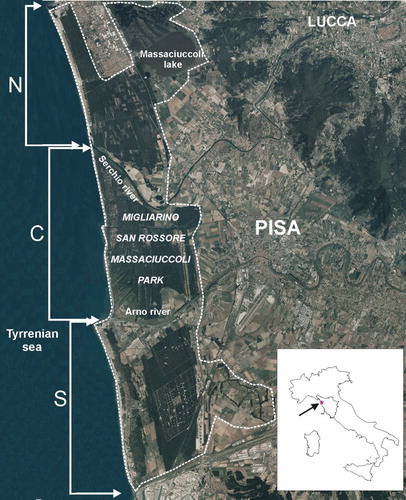
The Migliarino San Rossore Massaciuccoli park (Tuscany, Pisa) lies between 43° 51′ 36″ – 43° 35′ 25″ N and 10° 14′ 26″ – 10° 21′ 11″ E) (). It was established in 1979 in order to safeguard around 23,150 ha of dunes, mesophilous and xerophilous forests, wetlands and agro-forestry landscape, along approximately 30 km of coast. In 2004, the park was designated by UNESCO a Biosphere Reserve (http://www.parcosanrossore.org).
Figure 1. The study area and the three sectors of the investigated coast.
Although only constituting a fraction of the surface area of the park (about 394 ha, 1.7% of the total area), the recent dune bands represent an area of extraordinary richness in terms of unique habitats and endemic plants. At the same time, however, there is strong anthropogenic pressure, linked to seaside tourism and the presence of urban settlements, and on some stretches significant erosion (CitationGNRAC, 2006).
In order to characterize the climate, temperature and precipitation data were used from a weather station located at the eastern edge of the park (San Piero a Grado, Pisa). Annual average rainfall for the ten-year period from 1997 to 2007 was 773 mm, with the highest rainfall recorded in the autumn, and an annual average temperature of 14.4° C, with maximum values close to 30°C. The area exhibits a period of summer drought and water shortages from June to September. According to the bioclimatic classification of CitationRivas-Martinez and Rivas-Saenz (2015), the area has a Mediterranean macrobioclimate, with an upper meso-Mediterranean thermotype and a lower sub-humid ombrotype.
The coastline of the park can be divided into three different sectors in relation to coastal dynamics and anthropization ():
The northern sector (N), about 8 km long is subject to protective restrictions but freely accessible to the public and with a low level of urbanization. The coastline is prograding (approximately 140 m since 1954).
The central sector (C), about 11 km long is subject to protective restrictions and closed to the public. The coastline is undergoing rapid erosion (approximately 180 m since 1954).
The southern sector (S), about 11 km long, is open to the public with partial protective restrictions. The coastline is essentially in equilibrium and mostly highly urbanized in the areas behind the beaches (CitationBini, Casarosa, & Ribolini, 2008; http://www.regione.toscana.it/-/geoscopio-wms; http://www.parcosanrossore.org).
3. Methodology
The study concerned the area between the shoreline and the inner boundary of the maritime fixed dune in contact with other land cover types (i.e. inner woodlands, wetlands, agricultural and urban areas). The landward extent of the dune varies between 20 and 300 m depending on the sectors studied.
The study consisted of three stages:
Photo-interpretation of the vegetation landscape and vegetation surveys – The vegetation coverage and edges were initially assessed through an analysis of aerial 1:2000 orthophotos provided by the WMS Geoscope Service of the regional administration (2013) (http://www502.regione.toscana.it/geoscopio/ortofoto.html). Over time, over 250 phytosociological surveys have been carried out on identified dune vegetation. The study of the plant communities was performed according to the Zurich-Montpellier School, adopting the abundance–dominance indices proposed by CitationBraun-Blanquet (1964). The analysis and description of the coenoses takes account of the latest methodological acquisitions (CitationBiondi, 2011; CitationBiondi et al., 2014; CitationGéhu & Rivas-Martínez, 1981) in accordance with the International Code of Phytosociological Nomenclature (CitationWeber, Moravec, & Theurillat, 2000).
Detection of habitats – On the basis of previous field surveys (CitationBertacchi & Lombardi, 2014; CitationBertacchi et al., 2009, Citation2016; CitationSani et al., 2010; CitationTomei et al., 2004) and 2016 field updating, the vegetation was typified by the categories described by the Habitats Directive (Directive 92/43/EEC, MD 20 January 1999) (CitationBiondi et al., 2012; CitationCarranza et al., 2008; CitationEuropean Commission DG Environment, 2013). For the purposes of mapping and subsequent processing of the data gathered, the following habitats were considered ‘key’ features of psammophilous vegetation: 1210 Annual vegetation of drift lines; 2110 Embryonic dunes; 2120 White dunes; 2210, 2230, 2240 Crucianellion fixed dunes and Malcomietalia and Brachypodetalia dune grasslands; 2250 Coastal dunes with Juniperus spp. Habitats 9340 Quercus ilex and Quercus rotundifolia forests and 2270 Wooded dunes with Pinus pinea and/or Pinus pinaster were mapped as a single type. The three habitats 2210, 2230 and 2240 were also mapped as a single type, since they are part of a single mosaic they cannot be clearly separated from each other. Habitat 6420 Mediterranean tall humid herb grasslands and H7210 Calcareous fens, although not exactly distributed in the context of dune habitats, occur in humid dune slacks within the dune field, and were also mapped. In addition to natural habitat types, we also mapped ‘no habitat’ types: anthropic aphytoic area, that is, areas devoid of vegetation due to the permanent bathing establishments, parking areas, access roads, trampled paths and areas of sandy shores occupied on a seasonal basis and associated with bathing by tourists and locals.
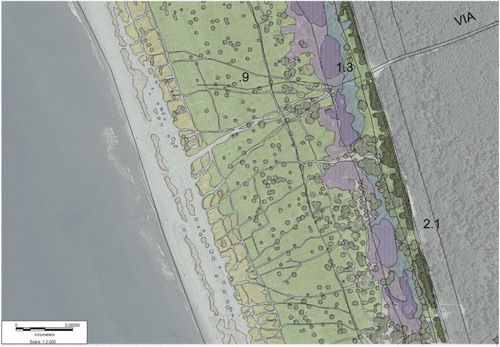
Mapping of habitat data – On the basis of high resolution and geo-referenced 1:2000 orthophotos (year 2013, and after field updating), overlaid onto the official 1:10,000 Regional Technical Map, assigning each digitized area to a specific phytosociological community and, consequently, to a specific habitat, the map of the coastal habitats was created using MapInfo 10.5® (). The final map layout was produced using CorelDraw X3 13.0®. Although the final map layout is 1:7500, the level of detail refers to the GIS processing at a scale of 1:2000. Due to the cartographic representation on a single sheet, in the final layout of the map, the central sector C was divided into two sub-sectors C1 and C2. The two shorelines of 1954 and 2013 were extrapolated from the aerial photos of the respective years. The entire stretch of the coastal resort of Marina di Pisa, consisting of an urban development up to the seashore, was excluded from the analysis.
Figure 2. Example of overlap of mapping (thematic layers) on the topographic map and orthophoto layers.
4. Results
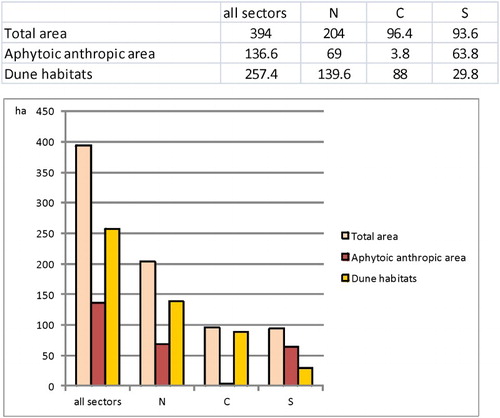
Analysis of the data relating to the surfaces of the different types of land cover mapped shows how the anthropic aphytoic area is, with a coverage of ca 136 ha, equal to 34.6% of the total investigated area. However, the land cover is distributed differently depending on the stretch of coast examined. In the north (N), of a total of 204 ha of total dune area, 69 ha are anthropic (31.8%); in the central sector, of a total of around 96.4 ha, only 3.8 are anthropic (3.9%); in the southern sector, 63.8 ha (68.1%) out of a total of 93.6 are anthropic. Surfaces occupied by the dune habitats decrease considerably moving from north to south: 139.6, 88 and 29.8 ha for the N, C and S sectors, respectively (). Despite being difficult to measure as a result of daily and seasonal fluctuations, the natural aphytoic zone (the portion of the Earth’s surface located between the shoreline and the annual vegetation of drift lines), occupies an overall area of around 30 ha.
Figure 3. Surface area (ha) relating to land cover of the investigated area.
In the strip pertaining to the sandy shore and dune environment, the field surveys revealed a large vegetational grouping, characterized by a total of 21 associations and sub-associations in addition to other phytocenotic elements ascribable to other syntaxonomic groups. The associations identified in the study area represent a phytocenotic grouping which is representative of the sedimentary coasts of the Tyrrhenian (CitationAcosta & Ercole, 2015; CitationArrigoni, 1990; CitationBertacchi & Lombardi, 2014; CitationBertacchi et al., 2009; CitationSani & Tomei, 2006; CitationVagge & Biondi, 1999). In line with European Directive 92/43, 11 different habitats were identified, three of which are of EU Interest (*), plus one ecotonal type (). On the basis of these data, the Map of Dune Habitats of the M.S.M Regional Park (Main Map) was created.
Table 1. Phytosociological communities (alliance, associations, sub-associations, facies, variants, groupings) identified in the investigated area and related habitats.
H1210 Annual vegetation of drift lines: The characteristic association of this habitat is Salsolo kali-Cakiletum maritimae (Costa & Manzanet 1981 corr. Rivas-Martínez et al. 2002) which is present in all of the three stretches of the coast mapped, though with the lowest value of the strictly psammophilous habitats. This habitat usually covers very limited areas in the dune zonation (CitationBiondi et al., 2014), and here coverage values vary considerably within the three sectors, decreasing from north to south, with low values in sector C (1.5 ha) and very low values in sector S (0.7 ha) ().
Figure 4. Surface area (ha) of the habitats of the investigated area.
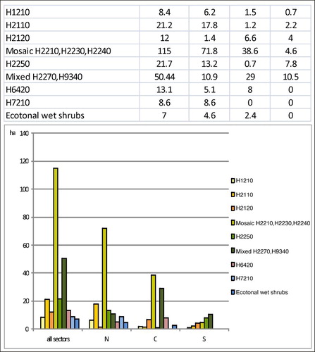
H2110 Embryonic shifting dunes: Characterized by the associations Echinophoro spinosae-Elymetum farcti Gehu 1988 and Elymo farcti-Spartinetum junceae (CitationVagge & Biondi 1999), in addition to some variants. This habitat shows high total coverage values, although with a discontinuous distribution, since it is only present without interruption in sector N (17.8 ha). In sector C (with respect to total percentage coverage of psammophilous vegetation), it is almost absent (1.2 ha, ca 1.3% of all dune habitats in this sector) ().
H2120 Shifting dunes along the shoreline with Ammophila arenaria (white dunes): Characterized by the associations Echinophoro spinosae-Ammophiletum arundinaceae (Géhu, Rivas-Martinez, R.Tx. 1992), with its sub-associations and facies, this habitat covers a very small area and shows a high degree of fragmentation in sector N (1.4 ha) (; Main Map). In sector C the habitat is extensive and without interruption, at least up to where erosion is not relevant (6.6 ha) (; Main Map). In sector S it shows higher coverage values in terms of the total percentage coverage of psammophilous vegetation in this sector (4 ha, ca 13% of dune habitats in this sector) ().
H2210 Crucianellion maritimae fixed beach dunes; H2230 Malcolmietalia dune grasslands; H2240 Brachypodietalia dune grasslands with annuals: These three habitats are barely separable from a cartographic perspective, given their natural admixture on the surfaces of the consolidated dunes, which is why they are included under the single cartographic theme. Characterized by three associations: Pycnomono rutifolii-Seseletum tortuosi (CitationArrigoni 1990), Sileno coloratae-Vulpietum membranaceae (Pignatti 1953; Géhu & Scoppola 1994) and Helichryso stoechadis-Cistetum eriocephali (Biondi 1999), this mosaic has the highest total coverage values (115 ha), and is particularly extensive in sector N (71.8 ha) ().
H2250* Coastal dunes with Juniperus spp.: This habitat is characterized by two associations, Asparago acutifolii-Juniperetum macrocarpae (R. et R. Molinier 1955; De Bolos 1962) and, to a lesser extent, Spartio juncei-Juniperetum macrocarpae (CitationVagge & Biondi 1999). This habitat has the highest coverage values in the retrodunal expanses of sector N (13.2 ha), and is also well represented, despite the anthropization, in sector S, albeit with a much lower occurrence than in the coverage of N (7.8 ha). It is almost non-existent and only accounts for some micro populations in the central sector C (0.7 ha) ().
H2270* Wooded dunes with Pinus pinea and/or Pinus pinaster and H9340: Quercus ilex and Quercus rotundifolia forests. Considering these two habitats in one mapping unit, they are represented by the mosaic of forest communities included in the Quercion ilicis Br. Bl. Ex (Molinier 1934) alliance. These mainly represent the inner framework behind the dunes of psammophilous coastal communities. Cartographically they were recognized up to the inner edge of the fixed dune.
H6420 Mediterranean tall humid herb grasslands of the Molinio-Holoschoenion: The characteristic association is Schoeno nigricantis-Erianthetum ravennae (Pignatti 1953) and its subassociations. Although it is not exactly a dune habitat (due to its strictly hygrophilous nature), this habitat is often present in the sandy depressions between the mosaic of habitats H2210, 2230, 2240 and habitat 2250, 2270 and 9340. In our study area, this habitat is only present in the N and C sectors with 5.1 and 8 ha, respectively ().
H7210* Calcareous fens with Cladium mariscus and species of the Caricion davallianae (in humid dune slacks): Phragmitetum australis (Gams 1927) and Cladietum marisci (Allorge 1922; Zobrist 1935) characterize this habitat. These are two markedly hydro-hygrophilous associations which are present exclusively in N, mixed with H2210 habitats, 2230 2240, H2250, H6420 in depressions behind the dunes (; Main Map).
Ecotonal wet shrubs in humid dune slacks: Small nucleus of mixed hygrophilous microwoods of Alnus glutinosa, Amorpha fruticosa, Populus sp.pl., Periploca graeca grow with very small surfaces in sectors N and C, around habitat H7210.
5. Discussion and conclusions
A breakdown of the data for the three sectors, characterized by different geomorphological and anthropic dynamics, shows that habitat distribution and surface area are significantly different ( and ; Main Map). This fact, on the basis of the investigations carried out to date (CitationBertacchi & Lombardi, 2014; CitationBertacchi et al., 2009, Citation2016), can be attributed both to the above-mentioned prograding and/or eroding coastline and to anthropogenic pressure.
The northern sector is characterized by three (two very broad, one extremely narrow) stretches of beach where there are no psammophilous habitats (; Main Map). These correspond to two areas subject to complete, permanent anthropic occupation and a pedestrian path. While habitats 2110, 2210/2230/2240 and 2250 occur along the entire stretch of coastline, and are interrupted only where permanently occupied anthropic areas exist, habitats 1210 and 2120 arise less frequently (Main Map, N sector). Habitat 1210 can be easily accounted for by the seasonal occupation by bathers and by the clean-up operations associated with them, which result in the total eradication of the habitat, as already described for sector S (CitationBertacchi & Lombardi, 2014; CitationBertacchi et al., 2009).
Habitat 2120 occurs less frequently and in a more fragmented manner than the neighbouring habitats. The fragmentation is probably connected with a high degree of trampling, and with the very large number of accessways to the beach and to the anthropic wear of the dune (research in progress). This anthropic wear is often parallel to the coastline, that is, on the summit of the dune relief that coincides with the habitat (; Main Map).
The central sector exhibits particular characteristics. These include the severe depletion of habitat 2250 which is only present at certain points along the entire sector, the almost total absence of H2110 and the exclusive presence of H1210 in a third of the sector that coincides with the stretch close to the mouth of the River Arno and protected by fences, where it is almost completely devoid of habitats, H1210, H2120 and the H2210 H2230, H2240 mosaic (, Main Map, C2). This can be interpreted as a consequence of severe erosion which has affected this sector for almost a century (CitationBini et al., 2008) with the habitats responding in different ways to the erosion (CitationBertacchi et al., 2016).
The southern sector (Main Map, S) exhibits an overall significant impoverishment affecting the psammophilous habitats, which visibly coincides with the historical exploitation of the beaches and the areas behind used for bathing purposes. Overall, all of the habitats are severely compromised, with the exception of 2250. This latter habitat, by establishing itself on consolidated dune, was recorded with a frequency of slightly over 50% of the observed cases. In this sector, the distribution of other psammophilous habitats is linked to the consolidated Juniperus dune, where such habitats often then form mosaics of microhabitats (CitationBertacchi & Lombardi, 2014; CitationBertacchi et al., 2009) (; Main Map, S).
The different presence of habitats due to the impact of anthropic pressure is clearly related to the different ways this is expressed and where it occurs. Where the anthropic impact is permanent (bathing facilities, buildings, car parks, etc.), all habitats have disappeared without distinction. Where the action is temporary, habitats 1210 and 2120 seem to be the most vulnerable (CitationBertacchi & Lombardi, 2014; CitationBertacchi et al., 2009). These results are in line with other studies in the literature (CitationErcole, Acosta, & Blasi, 2007; CitationLomba, Alves, & Honrado, 2008; CitationLucrezi, Saayman, & van der Merwe, 2014; CitationMartins, Neto, Gutierres, & Costa, 2014; CitationSantoro, Jucker, Carboni, & Acosta, 2012). The ‘natural’ alteration factor coastal erosion, is selective towards those species and plant communities that are not able to ‘follow’ the erosion process inwards. However, when the amount of erosion is significant, in terms of the retraction speed of the coast line, all the habitats have been eliminated (CitationBertacchi et al., 2016; CitationCiccarelli, 2014; CitationDoody, 2013; CitationFeagin, Sherman, & Grant, 2005; CitationSchlacher et al., 2008)
Although mapping tools are frequently used in environmental studies in coastal areas (CitationAcosta, Carranza, & Izzi, 2005; CitationISPRA, 2009; CitationTomasella et al., 2007; CitationVagge, Corradi, Ferrari, Balduzzi, & Mariotti, 2007), in the scientific literature in Italy little research has been published on the vegetation or habitat cartography of dune environments. Except for the cartographic work (1:5000) on dune vegetation by CitationPedrotti, Orsomando, and Cortini Pedrotti (1975), other thematic maps of coastal areas have almost always been carried out at smaller scales and, consequently, have few details with regard to the typology mapped (CitationArrigoni, Nardi, & Raffaelli, 1985; CitationTomei et al., 2004; CitationGuarino, Minissale, & Sciandrello, 2008). On the other hand, psammophilous plant communities/habitats always involve limited areas and linear landscape traits. In addition, the geomorphological mapping basemaps for sandy systems are often out-dated and at small-scale. Consequently, before the advent of digital technology, the large-scale cartographic reproduction of these environments was difficult. Today, the combined use of field surveys, aerial/satellite photos, LIDAR technology and GIS, provides a snapshot at any given time of the land occupied by plant communities or habitats, which are naturally subject to diachronic spatial fluctuations, owing to the natural instability of sedimentary coastal environments, and of following their dynamics over time (CitationAcosta et al., 2005; CitationBalduzzi, Bozzano, Corradi, Mariotti, & Vagge, 2006; CitationBertacchi & Lombardi, 2014; CitationCurr, Koh, Edwards, Williams, & Davies, 2000; CitationHöfle & Rutzinger, 2011; CitationMalavasi, Santoro, Cutini, Acosta, & Carranza, 2013). Thus, the data obtained and the map created provide a detailed contribution to the distribution of dune vegetation of the Park S. Rossore Migliarino Massaciuccoli and paint a fairly accurate picture of the vegetational landscape.
The digital version of this map, produced in MapInfo®, is in use at the Laboratory of Geobotany and Applied Botany, D.A.F.E, University of Pisa and will soon be available at the Migliarino San Rossore Regional Park. This work also represents a new contribution to the mapping of large-scale linear environments such as coastal areas, with a view to unifying the map surveys related to the Italian coast, and could provide a valuable tool for managing the entire coastline.
Software
The map was produced using MapInfo 10.5®. The final map layout was undertaken using CorelDraw X3 13.0®. The topographic layer is from the Tuscany Regional Geo-referenced data (GEOSCOPIO, http://www502.regione.toscana.it/geoscopio/cartoteca.html), using Gauss-Boaga plane coordinates – Roma 1940 [EPSG 3003]: Technical Map 1:10,000 – Sheets n° 260150, 260160, 272040, 272080, 272120, 272160, 283040. The orthophotographic layer is from WMS Geoscope Service of the Tuscany Region (Ortophotos 1:2000, year 2013; Ortophotos 1:10,000, year 1954) (http://www502.regione.toscana.it/geoscopio/ortofoto.html).
Dune habitats of the Migliarino – San Rossore – Massaciuccoli Regional Park (Tuscany – Italy).pdf
Download PDF (4.2 MB)Acknowledgements
The authors would like to thank the management and staff of the Migliarino San Rossore Massaciuccoli Regional Park, and T. Lombardi, C. Catassi, L. Vecci, G. Bocci, M. Zuffi for their support.
Disclosure statement
No potential conflict of interest was reported by the authors.
ORCID
Andrea Bertacchi http://orcid.org/0000-0002-3276-3876
Additional information
Funding
Related Research Data
References
- Acosta, A. T. R., Carranza, M. L., & Izzi, F. (2005). Combining land cover mapping with coastal dune vegetation analyses. Applied Vegetation Science, 8(2), 133–138. doi:10.1111/j.1654-109X.2005.tb00638.x
- Acosta, A. T. R., & Ercole, S. (Eds.). (2015). Gli habitat delle coste sabbiose italiane: ecologia e problematiche di conservazione. ISPRA, Serie Rapporti, 215/2015. Roma: Ispra.
- Acosta, A. T. R., Ercole, S., Stanisci, A., De Patta Pillar, V., & Blasi, C. (2007). Coastal vegetation zonation and dune morphology in some Mediterranean ecosystems. Journal of Coastal Reserach, 23(6), 1518–1524. doi:10.2112/05-0589.1
- Arrigoni, P. V. (1990). Flora e vegetazione della Macchia Lucchese di Viareggio (Toscana). Webbia, 44(1), 1–62. doi: 10.1080/00837792.1990.10670465
- Arrigoni, P. V., Nardi, E., & Raffaelli, M. (1985). La vegetazione del Parco Naturale della Maremma (Toscana). Dipartimento di Biologia Vegetale. Firenze: Università degli Studi di Firenze.
- Balduzzi, I., Bozzano, A., Corradi, N., Mariotti, L. M., & Vagge, I. (2006). The evolution of the dune fields of Platamona-Marritza (Northern Sardinia) using remote sensing and aerial imagery. Chemistry and Ecology, 22(1), 371–381. doi:10.1080/02757540600670620
- Bertacchi, A., & Lombardi, T. (2014). Diachronic analysis (1954–2010) of transformations of the dune habitat in a stretch of the Northern Tyrrhenian Coast (Italy). Plant Biosystems, 148(1–2), 227–236. doi:10.1080/11263504.2013.788572
- Bertacchi, A., Lombardi, T., & Bocci, G. (2009). Il paesaggio vegetale dell’ambiente dunale di Calambrone nel litorale pisano (Toscana settentrionale). Informatore Botanico Italiano, 41(2), 281–292.
- Bertacchi, A., Zuffi, M., & Lombardi, T. (2016). Foredune psammophilous communities and coastal erosion in a stretch of the Ligurian sea (Tuscany, Italy). Rendiconti Scienze Fisiche Accademia Lincei. doi:10.1007/s12210-016-0543-5
- Bini, M., Casarosa, N., & Ribolini, A. (2008). L’evoluzione diacronica della linea di riva del litorale pisano (1938–2004) sulla base del confronto di immagini aeree georeferenziate. Atti Società Toscana di Scienze Naturali, Memorie, Serie A, 113, 1–12.
- Biondi, E. (2011). Phytosociology today: Methodological and conceptual evolution. Plant Biosystems, 145(Suppl. 1), 19–29. doi: 10.1080/11263504.2011.602748
- Biondi, E., Blasi, C., Allegrezza, M., Anzellotti, I., Azzella, M. M., Carli, E., … Zivkovic, L. (2014). Plant communities of Italy: The Vegetation Prodrome. Plant Biosystems, 148(4), 728–814. doi: 10.1080/11263504.2014.948527
- Biondi, E., Burrascano, S., Casavecchia, S., Copiz, R., Del Vico, E., Galdenzi, D., … Blasi, C. (2012). Diagnosis and syntaxonomic interpretation of Annex I Habitats (Dir. 92/43/EEC) in Italy at the alliance level. Plant Sociology, 49(1), 5–37. doi:10.7338/pls2012491/01
- Braun-Blanquet, J. (1964). Pflanzensoziologie. Grundzüge der Vegetationskunde (3rd ed.). Wien: Springer.
- Brown, A. C., & McLachlan, A. (2002). Sandy shore ecosystems and the threats facing them: Some predictions for the year 2025. Environmental Conservation, 29, 62–77. doi: 10.1017/S037689290200005X
- Carranza, M. L., Acosta, A., Stanisci, A., Pirone, G. F., & Ciaschetti, G. P. (2008). Ecosystem classification and EU habitat distribution assessment in sandy coastal environments. The central Italy case. Environmental Monitoring and Assessment, 140(1), 99–107. doi:10.1007/s10661-007-9851-7
- Ciccarelli, D. (2014). Mediterranean coastal sand dune vegetation: Influence of natural and anthropogenic factors. Environmental Management, 54, 194–204. doi:10.1007/s00267-014-0290-2
- Cori, B. (1999). Spatial dynamics of Mediterranean coastal regions. Journal of Coastal Conservation, 5, 105–112. doi: 10.1007/BF02802747
- Costa, C. S. B., Cordazzo, C. V., & Seeliger, U. (1996). Shore disturbance and dune plant distribution. Journal of Coastal Research, 12(1), 133–140.
- Curr, R. H. F., Koh, A., Edwards, E., Williams, A. T., & Davies, P. (2000). Assessing anthropogenic impact on Mediterranean sand dunes from aerial digital photography. Journal of Coastal Conservation, 6, 15–22. doi: 10.1007/BF02730463
- Doody, J. P. (2013). Sand dune conservation, management and restoration. Heidelberg: Springer.
- Ercole, S., Acosta, A., & Blasi, C. (2007). Stato delle conoscenze e alterazioni indotte dal disturbo sulle fitocenosi delle coste sabbiose laziali. Fitosociologia, 44(1), 105–110.
- European Commission. (2013). Interpretation manual of European Union Habitats. EUR 28 DG Environment, Nature ENV B.3. Retrieved June 2015, from http://ec.europa.eu/environment/nature/legislation/habitatsdirective/docs/Int_Manual_EU28.pdf
- Feagin, R. A., Sherman, D. J., & Grant, W. E. (2005). Coastal erosion, global sea-level rise, and the loss of sand dune plant habitats. Frontiers in Ecology and the Environment, 3(7), 359–364. doi:10.1890/1540-9295(2005)003[0359:CEGSRA]2.0.CO;2
- Ferretti, O., Barsanti, M., Delbono, I., & Furia, S. (2003). Elementi di gestione costiera – Parte II Erosione Costiera: Lo stato dei litorali italiani. Roma: ENEA RT/2003/43/CLIM.
- Géhu, J. M., & Rivas-Martínez, S. (1981). Notions fondamentales de phytosociologie. In H. Dierschke (Ed.), Syntaxonomie (pp. 5–53). Vaduz: BerIntern Symposium IV-V.Cramer.
- GNRAC (2006). Lo stato dei litorali italiani. Studi Costieri. 10. E. Pranzini (Ed.), Firenze: Dipartimento di Scienze della Terra, Università di Firenze.
- Guarino, R., Minissale, P., & Sciandrello, S. (2008). La biodiversità vegetale e relativa cartografia del pS.I.C. ‘Torre Manfria’ (Gela – CL). Quaderni di Botanica Ambientale e Applicata, 19, 37–66.
- Hesp, P. A. (1991). Ecological processes and plant adaptations on coastal dunes. Journal of Arid Environments, 21, 165–191.
- Höfle, B., & Rutzinger, M. (2011). Topographic airborne LiDAR in geomorphology: A technological perspective. Zeitschrift für Geomorphologie, 55(2), 1–29. doi: 10.1127/0372-8854/2011/0055S2-0043
- ISPRA. (2009). Gli habitat in Carta della Natura. Schede descrittive degli habitat per la cartografia alla scala 1:50.000. Manuali e linee guida 49/2009. Roma: Author.
- ISPRA. (2011). Stato dell’ambiente. Mare e ambiente costiero (Report). Retrieved July 2013, from http://www.isprambiente.gov.it/files/pubblicazioni/statoambiente/tematiche2011/
- ISPRA. (2016). Consumo di suolo, dinamiche territoriali e servizi ecosistemici (Report). Retrieved June 2016, from http://www.isprambiente.gov.it/it/pubblicazioni/rapporti/consumo-di-suolo-dinamiche-territoriali-e-servizi-ecosistemici-edizione-2016
- Lega Ambiente. (2015). Salviamo le coste italiane (Report). Retrieved June 2015, from http://www.legambiente.it/contenuti/dossier/salviamo-le-coste-italiane-stop-consumo-di-suolo%20
- Lomba, A., Alves, P., & Honrado, J. (2008). Endemic sand dune vegetation of the northwest Iberian peninsula: Diversity, dynamics, and significance for bioindication and monitoring of coastal landscapes. Journal of Coastal Research, 24(2B), 113–121. doi: 10.2112/05-0610.1
- Lucrezi, S., Saayman, M., & van der Merwe, P. (2014). Influence of infrastructure development on the vegetation community structure of coastal dunes: Jeffreys Bay, South Africa. Journal of Coastal Conservation, 18, 193–211. doi:10.1007/s11852-014-0307-2
- Macchia, U., Pranzini, E., & Tomei, P. E. (2005). Le dune costiere in Italia. Pisa: Felici.
- Malavasi, M., Santoro, R., Cutini, M., Acosta, A. T. R., & Carranza, M. L. (2013). What has happened to coastal dunes in the last half century? A multitemporal coastal landscape analysis in Central Italy. Landscape and Urban Planning, 119, 54–63. doi:10.1016/j.landurbplan.2013.06.012
- Martìnez, M. L., Psuty, N. P., & Lubke, R. A. (2004). A perspective on coastal dunes. In M. L. Martìnez & N. P. Psuty (Eds.), Coastal dunes. Ecology and conservation (pp. 3–10). Heidelberg: Springer.
- Martins, M., Neto, C., Gutierres, F., & Costa, J. C. (2014). Bioindicators of erosive dynamics in beach and dune systems in the Portuguese mainland coast. Documents Phytosociologiques; Série, 3(1), 325–337.
- Maun, M. A. (2009). The biology of coastal sand dunes. Oxford: Oxford University Press.
- Pedrotti, F., Orsomando, E., & Cortini Pedrotti, C. (1975). Carta della vegetazione del Lago di Burano e della duna di Capalbio (Grosseto). Firenze: LAC.
- Pignatti, S. (1993). Dry coastal ecosystems of Italy. In E. Van Der Maarel (Ed.), Dry coastal ecosystems. Polar regions and Europe (pp. 379–390). Ecosystems of the world 2A, Amsterdam: Elsevier.
- Prisco, I., Acosta, A. T. R., & Ercole, S. (2012). An overview of the Italian coastal dune EU habitats. Annali di Botanica, 2, 39–48. doi:10.4462/annbotrm-9340
- Provoost, S., Ampe, C., Bonte, D., Cosyns, E., & Hoffmann, M. (2004). Ecology, management and monitoring of grey dunes in Flanders. Journal of Coastal Conservation, 10, 33–42. doi: 10.1652/1400-0350(2004)010[0033:EMAMOG]2.0.CO;2
- Rivas-Martìnez, S., & Rivas-Saenz, S. (2015). Globalbioclimatics. Retrieved July 2015, from http://www.bioclimatics.org
- Sani, A., Monacci, F., Trimarchi, S., & Tomei, P. E. (2010). La vegetazione della tenuta di migliarino. Pisa: ETS.
- Sani, A., & Tomei, P. E. (2006). La vegetazione psammofila del litorale di San Rossore (Toscana settentrionale) e la sua importanza conservazionistica. Parlatorea, 8, 99–119.
- Santoro, R., Jucker, T., Carboni, M., & Acosta, A. T. R. (2012). Patterns of plant community assembly in invaded and non-invaded communities along a natural environmental gradient. Journal of Vegetation Science, 23(3), 483–494. doi:10.1111/j.1654-1103.2011.01372.x
- Schlacher, T. A., Schoeman, D. S., Dugan, J., Lastra, M., Jones, A., Scapini, F., & McLachlan, A. (2008). Sandy beach ecosystems: Key features, sampling issues, management challenges and climate change impacts. Marine Ecology, 29, 70–90. doi:10.1111/j.1439-0485.2007.00204.x
- Tomasella, M., Vidali, M., Oriolo, G., Poldini, L., Comin, S., & Giorgi, R. (2007). Valutazione della qualità degli habitat della costa sedimentaria (Laguna di Marano e Grado) e della costa a falesie (Costiera triestina): applicazione del metodoEsAmbI. Fitosociologia, 44(1), 17–31.
- Tomei, P. E., Bertacchi, A., Sani, A., & Consiglio, M. O. (2004). La vegetazione della Tenuta di San Rossore. Note esplicative alla Carta della vegetazione di San Rossore 1:10.000. Pisa: Pacini.
- Vagge, I., & Biondi, E. (1999). La vegetazione delle coste sabbiose del Tirreno settentrionale italiano. Fitosociologia, 36(2), 61–96.
- Vagge, I., Corradi, N., Ferrari, M., Balduzzi, I., & Mariotti, L. M. (2007). Aspetti vegetazionali e morfosedimentologici dei campi dunari di Platamona-Marritiza con particolare riguardo all’area di Marina di Sorso (sardegna settentrionale). Fitosociologia, 44(1), 33–48.
- Valpreda, E., & Simeoni, U. (2003). Assessment of coastal erosion susceptibility at the national scale: The Italian case. Journal of Coastal Conservation, 9, 43–48. doi:10.1652/1400-0350(2003)009[0043:AOCESA]2.0.CO;2
- Van der Maarel, E. (2003). Some remarks on the functions of European coastal ecosystems. Phytocoenologia, 33, 187–202. doi: 10.1127/0340-269X/2003/0033-0187
- Van der Meulen, F., & Udo de Haes, H. A. (1996). Nature conservation and integrated coastal zone management in Europe: Present and future. Landscape and Urban Plannning, 34, 401–410. doi: 10.1016/0169-2046(95)00234-0
- Weber, H. E., Moravec, J., & Theurillat, J. P. (2000). International Code of Phytosociological Nomenclature (3rd ed.). Journal of Vegetation Science, 11, 739–768. doi: 10.2307/3236580