
ABSTRACT
A 1:5700 scale map of the recently deglaciated foreland of Skaftafellsjökull, Iceland as it appeared in 2007, depicts a typical active temperate glacial landsystem with a clear pattern of sequentially changing push moraine morphologies, including remarkable hairpin-shaped moraines, indicative of spatial and temporal variability in process-form regimes in glacier sub-marginal settings. Similar to other Icelandic glacier forelands, this demonstrates that the piedmont glacier lobes of the region have developed strong longitudinal crevassing and well-developed ice-marginal pecten during their historical recession from the Little Ice Age maximum moraines, likely driven by extending ice flow and poorly drained sub-marginal conditions typical of the uncovering of overdeepenings. Additionally, the localized development of a linear tract of kame and kettle topography is interpreted as the geomorphic and sedimentary signature of thrust stacked and gradually melting debris-rich glacier ice, a feature hitherto unrecognized in the Icelandic active temperate lobe landsystem signature.
1. Introduction
The aim of the mapping project presented here was to assess, at the scale of 1:5700 (Main Map), the spatial distribution of post-Little Ice Age glacial sediment–landform associations on the Skaftafellsjökull foreland (), southern Iceland and to thereby test the hypothesis that the active temperate piedmont lobes of the southern Vatnajökull and Öræfajökull ice caps have produced similar landsystem signatures that record temporally changing, climatically and topographically controlled glacial process-form regimes (cf. CitationChandler, Evans, & Roberts, 2016; CitationChandler, Evans, Roberts, Ewertowski, & Clayton, 2015; CitationEvans & Orton, 2014; CitationEvans, Ewertowski, & Orton, 2015; CitationJónsson et al., 2016). More specifically, the occurrence on these glacier forelands of widespread sawtooth moraines with unusually long limbs/crevasse infills (; CitationEvans et al., 2015; CitationEvans, Nelson, & Webb, 2010; CitationPrice, 1970) has been linked to the intensive development of longitudinal crevassing in lobate snouts, operating only over the most recent decades of ice recession and hence apparently linked to extending ice flow and poorly drained sub-marginal conditions. Such conditions appear to have prevailed since recession into prominent overdeepenings (CitationCook & Swift, 2012) located behind overridden moraine arcs and are therefore likely to dominate for several decades into the future if ice recession continues at its present rate (cf. CitationBennett, Evans, Carbonneau, & Twigg, 2010; CitationChandler et al., 2015, Citation2016; CitationEvans et al., 2015; Phillips, Finlayson, Bradwell, Everest, & Jones, Citation2014; CitationPhillips, Finlayson, & Jones, 2013).
Figure 1. Aerial view of the Skaftafellsjökull snout and foreland in 2012 showing the more recent push moraines and their sawtooth planform and localized superimposition. The superimposition of numerous moraines dating from the 1960s through the 1990s and culminating in the early mid-1990s readvance, are visible in the middle of the image. Also well illustrated in this view is the radial crevassing and pecten of the glacier margin.

2. Mðods of map production
The Skaftafellsjökull snout and its foreland were mapped using colour aerial photographs taken by the Airborne Research and Survey Facility (ARSF) of the Natural Environment Research Council UK in 2007. Coordinates for ground control points (GCP) were collected in September 2013 using dGPS over the glacier foreland (27 points) and on the surrounding hill summits (24 points). Twenty-six points were used as GCP to establish absolute orientation for the generation of an orthophotograph and digital elevation model (DEM). Internal error for this GCP in 3D space was 0.73 m (x-error = 0.23 m; y-error = 0.29 m, z-error = 0.63 m). A further 25 points were utilized as independent checkpoints to assess the errors. The error in 3D space based on these 23 checkpoints was 0.85 m (x-error = 0.32; y-error = 0.46 m; z-error = 0.65 m). A total of four photographs were orthorectified and mosaicked using Agisoft Photoscan Professional Edition. Mapping was then undertaken on a coloured ink film overlain on the orthophotograph and involved the simultaneous interpretation of surface materials and landforms based on ground truth fieldwork in the summers of 2012–2014 and the desk top viewing of stereoscopic images. The orthophotograph processing and contour generation were both performed in ESRI ArcGIS. Contours were overlain on the surficial geology and geomorphology and are spaced differently according to the general topography so that the more subdued terrain of the glacier foreland was contour spaced at 5-m intervals below 200 m a.s.l. and the higher relief mountain sides at the lateral margins of the glacier at 20 m intervals above 200 m a.s.l. The mountain sides are depicted by the orthophotograph image and have not been mapped, as they contain no glacial deposits but comprise instead bedrock outcrops and minor areas of scree and other colluvium. The same approach is taken with the glacier surface, which is represented by the orthophotograph in order to depict ice structures such as crevasses and debris bands. The map overlay containing the base data was manually digitized on a large format Cal-Comp tablet digitizer using MapData vector digitizing software. The digitized vector files for the base data were converted from MapData format into ArcInfo ‘generate’ format for importing into Adobe Illustrator. The map is at a scale of 1:5700 when printed on an A1 sheet.
3. History of glacier recession
The Icelandic south coast glaciers have been predominantly undergoing recession since the early 1900s, shortly after reaching their Little Ice Age maximum limits at around 1870–1890 AD, although the 1960s–1990s were decades of slower recession, with some glaciers undergoing significant readvances (; CitationBoulton, 1986; CitationBradwell, Sigurðsson, & Everest, 2013; CitationHannesdóttir, Björnsson, Pálsson, Aðalgeirsdóttir, & Guðmundsson, 2015). Overall, the active temperate nature of these glaciers (cf. CitationEvans & Twigg, 2002) is manifest in short annual readvances during overall recession in response to the winter period of reduced ablation, giving rise to the emplacement of inset sequences of push moraines (CitationBoulton, 1986; CitationChandler et al., 2015, Citation2016). In terms of general recession, Icelandic glaciers are thought to be particularly sensitive to inter-annual variations in summer average air temperatures to which they have a very rapid response time (CitationBjörnsson et al., 2013; CitationBjörnsson & Pálsson, 2008; CitationBradwell, 2004; CitationBradwell et al., 2013; CitationChandler et al., 2016; CitationSigurðsson, Jónsson, & Jóhannesson, 2007). Hence landforms such as push moraines are produced on an annual, possibly even sub-annual basis (CitationChandler et al., 2015, Citation2016; CitationEvans & Twigg, 2002; CitationKrüger, 1995, Citation1996; CitationPrice, 1970; CitationSharp, 1984). Additionally, the post-Little Ice Age glacier recession pattern has been interrupted by some more substantial advances in response to climate triggers. Most notable was an early to mid-1990s readvance, which appears to correspond with a positive North Atlantic Oscillation (NAO) index (CitationBradwell, Dugmore, & Sugden, 2006). This period from 1989 to 1994 was characterized by more storms tracking across Iceland, bringing greater precipitation and therefore higher rates of snow accumulation. As a result, a number of south Vatnajökull outlet glaciers, including Skaftafellsjökull but at a slightly later date of 1995–1998, readvanced and maintained a quasi-stationary ice front for around five years (cf. CitationBennett & Evans, 2012; CitationBradwell et al., 2006; CitationEvans, Shand, & Petrie, 2009). Although this resulted in the construction of a composite push moraine similar to those of other glacier forelands (CitationEvans, 2003, Citation2005, Citation2013; CitationEvans & Hiemstra, 2005; CitationKrüger, 1993), Skaftafellsjökull’s margin remained relatively stable between the 1960s and 1990s () and this resulted in the push moraines of that period being very closely spaced and locally superimposed, with the 1990s readvance signature being recorded by its superimposition on an already complex moraine assemblage ().
Figure 2. Variations since 1931 of the non-surge-type margins of the Vatnajökull South Region glaciers, using data from Veðurstofa Íslands (Icelandic Meteorological Office) and the Icelandic Glaciological Society. Data compilation by Ben Chandler.
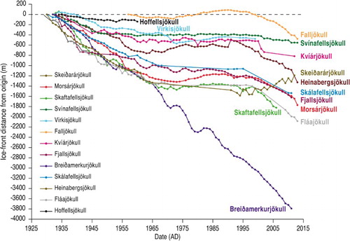
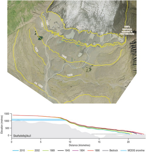
Ages on moraines and hence on the snout recession history at Skaftafellsjökull have been determined by lichenometric dating and historical documentation and are summarized in . CitationÞórarinsson (1956) identified the positions of the glacier snout in 1904, based upon the survey of the Danish Geodetic Survey, in 1945, based on the US Army Air Force (USAAF) aerial photography, and in 1954 at the time of his field observations. Ages for specific moraines were derived by CitationThompson and Jones (1986) and CitationThompson (1988) using lichenometry, from which former ice margins were identified for 1870 (the Little Ice Age maximum), 1930, 1934, 1935, 1939, 1945, 1953, 1958 and 1969. At the time of the CitationThompson and Jones (1986) study the glacier was undergoing a readvance and its 1984 position was the same as that of 1969. More recent snout recession (1996–2000) has been documented by CitationMarren (2002) and related to proglacial outwash channel changes. He identifies a significant moraine dating to the 1995–1998 readvance, inside of which the snout has thinned and constructed annual recessional push moraines on a foreland that is becoming increasingly flooded by proglacial/supraglacial lakes. Snout thinning from 1890 to 2010 AD and the initial uncovering of a shallow overdeepening, in which the proglacial/supraglacial lakes are beginning to pond, is illustrated by CitationHannesdóttir et al. (2015) and reproduced in . The area and volume changes of Skaftafellsjökull are calculated in their study from a series of DEMs compiled from glacial geomorphology, historical photographs, maps, aerial images, dGPS measurements and Lidar data.
Figure 3. The post-Little Ice Age positions of Skaftafellsjökull. Upper panel shows selected ice-marginal positions depicted on the 2007 aerial imagery (NERC ARSF orthophotograph) and derived from aerial photographs dating to 1954, 1965 and 1980 in combination with maps compiled by CitationÞórarinsson (1956), CitationThompson and Jones (1986) and CitationThompson (1988). Lower panel shows the longitudinal profiles for the snout over the period 1890–2010 with each time slice positioned over the subglacial topography (grey). This also shows the average equilibrium line altitude (ELA) as a light blue horizontal line (modified from CitationHannesdóttir et al., 2015).
4. Glacial geomorphology and surficial geology
Only two surficial geology map units, till and glacifluvial deposits are identified on the glacier foreland on the 1:5700 scale map (Main Map), both of which are colour-coded and associated with specific landforms and geomorphic process-form regimes, the landforms being depicted using symbology. These landform and sediment mapping classifications follow the protocol established for previous Icelandic glacier foreland maps (CitationBennett et al., 2010; CitationChandler et al., 2015; CitationEvans et al., 2009; CitationEvans & Orton, 2014; CitationEvans & Twigg, 2002; CitationHowarth & Welch, 1969a, Citation1969b).
4.1. Till and moraines and associated features
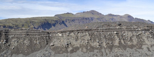
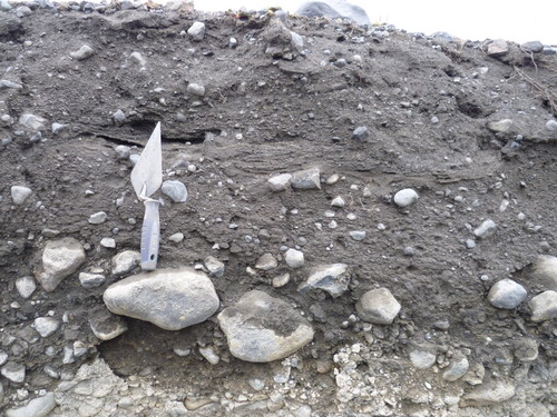
The till and moraines surficial geology map unit is characterized by features typical of recently deglaciated forelands in southern Iceland, such as densely spaced push moraines and associated flutings. In detail, the push moraines are sawtooth in planform and are draped over three broad and relatively smoothed arcuate ridges, which are clearly identifiable on the DEM of the foreland (Main Map inset). The smoothing of these ridges is a product of glacier overriding, as indicated by the occurrence on their surfaces of streamlined subglacial till bedforms or flutings and subtle drumlins. Such smoothed arcuate ridges have previously been classified as ‘overridden moraines’ in Iceland glacier foreland maps where they are demonstrably cored by till (CitationEvans et al., 2009, Citation2015; CitationEvans & Orton, 2014, CitationEvans, Archer, & Wilson, 1999; CitationKrüger, 1994) but they can also contain cores of glacifluvial sediment that were prograded as ice-contact outwash fans prior to glacier overriding (CitationBoulton, 1987). Exposures through the smoothed ridges on the Skaftafellsjökull foreland reveal glacifluvial outwash overlain by multiple subglacial tills (; CitationEvans et al., submitted). They are therefore classified here as ‘overridden moraine/fan complexes’. During the most recent stages of post-Little Ice Age glacier recession the relatively higher relief of the exposed overridden moraine/fan complexes has effectively channelled proglacial outwash into linear sandar (see Section 4.2).
Figure 4. A 4-m high exposure through one of the overridden moraine/fan complexes on the middle Skaftafellsjökull foreland, displaying boulder-rich glacifluvial outwash (lower unit) overlain by subglacial tills (darker upper units) which thicken into push moraines. Dashed lines indicate boundaries between units (see CitationEvans et al., submitted for details on the sedimentology of the foreland).
The push moraines are commonly around 1–5 m high and broadly arcuate in planform, even though in detail their crests are commonly crenulated or sawtooth in planform (). Sawtooth planforms are common around the Icelandic south coast glacier margins and particularly well developed on those parts of forelands that have been deglaciated over the last 50 years (CitationChandler et al., 2015, Citation2016; CitationEvans et al., 2015; CitationPrice, 1970). This distinct planform reflects the morphology of the glacier snout, specifically where snouts are indented by radial crevasses or pecten so that the glacier margin not only bulldozes or pushes up proglacial deposits but also loads underlying, saturated till and thereby forces it to squeeze up into the pecten (CitationPrice, 1970). This process of crevasse squeeze ridge formation can operate also glacier sub-marginally to form networks of ridges that are orientated obliquely to push moraine crests and sub-parallel to glacier flow direction, the latter characteristic allowing their differentiation from flutings. The most extensive examples of such features have been mapped on the foreland of Fláajökull by CitationEvans et al. (2015), where they are classified separately from push moraine ridges as crevasse fills and are associated with till eskers. At Skaftafellsjökull the pecten infills are more closely associated with extremely sawtooth (hairpin-shaped) push moraine ridges and/or are orientated in such a way as to closely resemble the long arms of hairpins, hence they are mapped as moraine ridges. Closer field inspection may reveal that some of these ridges, like those at Fláajökull, are indeed crevasse fills or till eskers; these landforms, togðer with squeezed push moraines (CitationPrice, 1970), occupy positions on a form continuum that is associated with till squeezing and bulldozing in glacier sub-marginal to marginal locations.
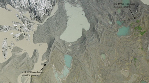
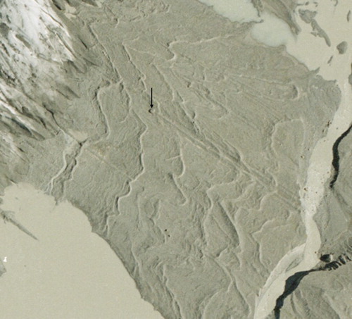
Figure 5. Aerial photograph (NERC ARSF 2007 orthophotograph) extract showing closely spaced and extensively overprinted sawtooth push moraines on the inner foreland. The closely spaced ridge complex comprising the mid-1990s readvance moraine (arrowed) extends across the middle to top right of the image. The post-1965 moraines extend across the lower half of the image.
The flutings (or flutes) on the foreland are typically tens of metres in length, predominantly composed of subglacially deformed till and commonly associated with lodged stoss-boulders (). In plan form the flutings are arranged in arcuate sets between push moraines, each set slightly offset from one another. This records the slight ice flow directional changes at the glacier snout from year to year. However, some larger flutings can be traced precisely through several push moraines (), indicating that ice flow direction changed little between subsequent years.
Figure 6. Aerial photograph (NERC ARSF 2007 orthophotograph) extract showing sawtooth moraines on the recently exposed foreland togðer with well-developed flutings that include a clear stoss boulder/fluting pair at the image centre. Stoss boulder is arrowed.
The till that comprises the moraines and flutings is characterized by multiple units of matrix-supported diamicton each up to 1.2 m thick and displaying either massive, fissile or pseudo-stratified structure (; CitationEvans et al., submitted). The more restricted pseudo-stratified outcrops are potentially the rare products of melt-out from supercooled glacier ice, a notable feature of the Icelandic south coast glacier lobes (CitationCook et al., 2010; CitationCook, Graham, Swift, Midgeley, & Adam, 2011; CitationCook, Knight, Richard, Robinson, & Adam, 2007; CitationCook, Swift, Graham, & Midgley, 2011; CitationRoberts et al., 2002), but predominantly the diamictons display features that are diagnostic of a subglacial traction till genesis such as fissility, compaction and reasonably strong clast macrofabrics (CitationEvans, 2000, Citation2017; CitationEvans et al., submitted; CitationEvans, Phillips, Hiemstra, & Auton, 2006; CitationEvans, Roberts, & Evans, 2016; CitationJónsson et al., 2016).
Figure 7. Typical stratigraphic sequence through the till and moraines surficial map unit, showing fissile, matrix-supported diamictons (subglacial traction tills) separated by a pseudo-stratified diamicton interpreted as a potential melt-out till (see CitationEvans et al., submitted for details).
4.2. Glacifluvial deposits and landforms
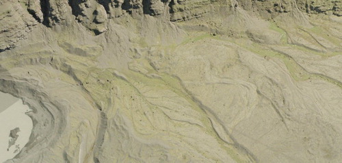
Typical of the Icelandic south coast glacier lobes, coarse-grained gravels and sands or glacifluvial deposits on the foreland are contained within two dominant sediment–landform assemblages (e.g. CitationMaizels, 1993; CitationMarren, 2002, Citation2005; CitationPrice, 1969). Firstly, proglacial outwash accumulated to form sandur fans beyond the Little Ice Age maximum moraines, where meltwater flow was unimpeded by local morainic topography and coalesced with the more extensive jökulhlaup-fed sandur of neighbouring Skeiðarárjökull. Secondly, a series of linear sandar occur within the confines of the Little Ice Age maximum limit, where the arcuate ridges of the overridden moraine/fan complexes have directed proglacial meltwater in topographically confined corridors. Additionally, large quantities of glacifluvial sediment are contained within kame terraces along the lower mountain slopes of Varða on the eastern foreland (), where glacier snout oscillations have constructed small push moraines composed of glacifluvial outwash on the terrace edges. In places the kame terraces have been modified and/or overprinted by paraglacial fans derived from reworked morainic and terrace debris.
Figure 8. Aerial photograph (NERC ARSF 2007 orthophotograph) extract showing the kame terraces located beneath the bedrock cliffs of Varða on the east side of the foreland.
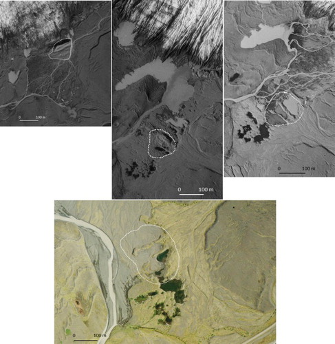
A small but prominent area of kame and kettle topography occurs within the linear sandur on the east-central foreland () where part of the glacier snout has been buried by outwash and hence has been melting out to form expansive water-filled kettle holes since the 1950s. Aerial photographs reveal that this kame and kettle terrain has gradually evolved into a linear assemblage that is aligned ice-flow parallel, which is unusual for Iceland’s active temperate piedmont lobes because such localized kame and kettle topography is more usually demonstrably the product of shallow snout burial by laterally draining outwash or expanding englacial esker tunnel fills (CitationBennett et al., 2010; CitationBennett & Evans, 2012; CitationEvans et al., 2009, Citation2015; CitationEvans & Twigg, 2002; CitationPrice, 1969, Citation1971; CitationStorrar, Evans, Stokes, & Ewertowski, 2015). It also contains a sequence of transverse moraine ridges which are unlike those of the push moraines on the adjacent till uplands in that they appear to have been gradually pitted and reduced in volume over time. Moreover, the ice-marginal zone in 1954 was dominated by a composite/thrust moraine with conspicuous melt-out pits on its distal ridges (). The spatial distribution of the kame and kettle topography clearly demarcates an elongate ice-filled depression within which debris-charged glacier ice has been thrust and gradually melted-out to form a complex of constructional ridges and controlled moraine (sensu CitationEvans, 2009). This is unusual for active temperate glaciers and hence this landform assemblage potentially represents a zone of glacier-sub-marginal supercooling located in an elongate depression or possible tunnel valley.
Figure 9. Aerial photograph extracts (Landmælingar Islands 1954–1980 and NERC ARSF 2007 orthophotograph) of approximately the same area of the foreland and demonstrating the temporal evolution of the linear tract of kame and kettle topography thought to lie over a subglacial tunnel valley. Note the evolution of transverse moraine ridges which are aligned with, but are unlike those of, the push moraines on the adjacent till uplands: (a) in 1954 shows a composite/thrust moraine (outlined) being constructed at the snout with conspicuous melt-out pits on its distal ridges. This likely shows the thrusting of buried glacier ice because extensive melt-out pits occur in the outwash beyond the moraine; (b) 1965 shows the isolation of the thrust moraine (outlined) and associated controlled moraine ridges in the middle of extensive kame and kettle topography; (c) 1980 shows the expansion and coalescence of kettle holes, further isolating the remains of the thrust/controlled ridges (outlined); (d) 2007 shows the more subdued topography created by advanced melt-out and kettle hole infilling and drainage. Note that recent outwash surfaces have been constructed from the landforms. Area of former thrust/controlled ridges outlined.
5. Landform zonation and implications for spatial and temporal changes on active temperate glacier forelands
The glacial landsystem represented by the Skaftafellsjökull foreland is typical of the Icelandic south coast active temperate piedmont lobes wherein widespread basal melting and deformation of water-soaked till produces flutings and sub-marginal till squeezing and pecten/radial crevasse infilling produces sawtooth or hairpin-shaped moraines. The most characteristic process-form regime of these active temperate glaciers is that of recessional annual push moraine construction in response to seasonal temperature fluctuations, with the tendency of the glacier snout to commonly display winter advances even when in overall recession (CitationBoulton, 1986; CitationChandler et al., 2015, Citation2016; CitationEvans & Twigg, 2002; CitationKrüger, 1995). Composite push moraine complexes, recording periods of positive mass balance when glacier margins are subject to relative stability, are also common. The large volumes of meltwater produced by active temperate glaciers also gives rise to substantial glacifluvial landform-sediment associations, such as sandur fans, linear sandar and kame terraces, so that it is common to see isolated remnants or ‘islands’ of the former subglacial bedforms, tills and associated push moraines lying within sandar or separating the corridors of linear sandar.
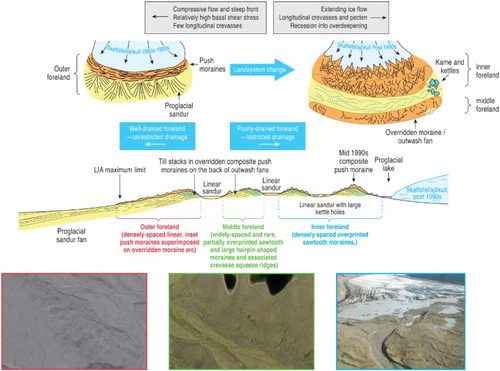
Within these active temperate glacial landsystems it is possible to further identify zones which appear to document spatial and temporal change in process-form regimes over historical timescales (cf. CitationEvans, 2013; CitationEvans et al., 2015; CitationEvans & Orton, 2014; CitationKrüger, 1994). At Skaftafellsjökull, the foreland that has been exposed since the beginning of the twentið century displays a distinct set of landform patterns or zones that can be related to changing glacier margin dynamics and associated landform development through time (). The larger scale morphology of the foreland comprises drumlin- and fluting-covered overridden moraines or outwash (sandur) fans, which occur as three major arcs across the foreland and are overprinted by the recessional push moraines of the post-Little Ice Age period. These later push moraines vary in morphological detail and thereby define three general zones: (1) the outer foreland contains closely spaced and largely straight-crested moraines deposited in the 1880s–1920s. Meltwater streams formed unconfined outwash fans that emanated from breaks in the moraine ridges; (2) the middle foreland contains widely spaced and rare, partially overprinted hairpin-shaped moraines with very long limbs produced by till squeezing into crevasses, indicating that the glacier snout had developed extensive radial crevasses; (3) the inner foreland contains densely spaced, heavily overprinted sawtooth moraines and includes the early mid-1990s composite push moraine. Once the glacier snout had retreated to the middle foreland the meltwater streams started to develop snout-parallel linear tracts of outwash (sandar) as a result of the topographic control exerted by the overridden moraine arcs. The streams therefore drained into one major outlet, which is now occupied by the Skaftafellsá. Within this tripartite zonation lies the localized kame and kettle topography of the east-central foreland, which we speculate is related to the development and thrusting of supercooled glacier ice located over a subglacial tunnel valley.
Figure 10. Conceptual model depicting the zonation of the landsystem at Skaftafellsjökull and its relation to the temporal and spatial changes in glacier marginal conditions and topography. Aerial photograph extracts show the details of the landforms in each zone.
6. Conclusion
The glacial landsystem represented by the deglaciated foreland of Skaftafellsjökull is typical of the Icelandic south coast active temperate piedmont lobes but contains evidence of landform zonation, specifically in the form of changing push moraine morphology, which records spatial and temporal change in process-form regimes over historical timescales. Such process-form regime changes have been identified also in other foreland landsystem signatures in the region and hence it appears that they are a further diagnostic characteristic of the active temperate glacial landsystem and reflect the localized interplay of glacier snout morphology/structure and topography.
Similar to other south Iceland glacier forelands, the overridden moraine/fan complexes demarcate the locations of former composite push moraine construction over ice-contact fans, with multiple till units being emplaced by glacier marginal till thickening during periods of glacier stillstand (cf. CitationEvans et al. 2016; CitationEvans & Hiemstra, 2005). These features were overridden and fluted by the glacier during its advance to the Little Ice Age maximum but were not significantly modified and hence, during later ice recession, they exerted a topographic control on the routing of glacial meltwater and the deposition of glacifluvial outwash in snout-parallel linear sandar tracts.
Changing morphologies of recessional push moraines produced since the Little Ice Age maximum define three general zones indicative of changing process-form regimes over historical timescales. The outer foreland with its closely spaced and largely straight-crested moraines and unconfined outwash fans contrasts markedly with the middle foreland and its widely spaced and rare, partially overprinted hairpin-shaped moraines and linear sandar and the inner foreland and its densely spaced, heavily overprinted sawtooth moraines. This zonation indicates that the piedmont glacier lobe developed strong longitudinal crevassing and well-developed ice-marginal pecten during its historical recession, likely driven by extending ice flow and poorly drained sub-marginal conditions typical of the uncovering of overdeepenings. Based upon the analyses of CitationHannesdóttir et al. (2015) on the snout morphologies and subglacial topographies of the region’s piedmont lobes, it is apparent that this landform zonation is indicative of initial recession into bedrock overdeepenings and it will likely be superceded by the development of glacilacustrine depo-centres and more rapid snout recession rates. Also related to the occurrence of overdeepenings is the localized development of supercooled glacier ice and its geomorphic and sedimentary signature, which we propose is well represented at Skaftafellsjökull and worthy of continued monitoring in order to improve our ability to identify supercooling in palaeoglaciological reconstructions.
Software
Aerial photographs were orthorectified and mosaicked using Agisoft Photoscan Professional Edition. Orthophotograph processing and contour generation were both performed in ESRI ArcGIS. The map overlay containing the base data was manually digitized on a large format Cal-Comp tablet digitizer using MapData vector digitizing software. The digitized vector files for the base data were converted from MapData format into ArcInfo ‘generate’ format for importing into Adobe Illustrator.
Map design
The map follows the protocol for mapping surficial deposits in Iceland and hence has a colour coding and symbology scheme that follows previous Iceland landsystems papers. It is designed to portray the areal extent of surficial glacial and glacially related materials by colour coding areas mapped from aerial photography. Glacial landforms are represented over this colour coding using line symbols. The relationship between topography and sediments and landforms is portrayed by overlaying the contours derived from photogrammetry.
Skaftafellsjökull, Iceland: Glacial geomorphology recording glacier recession since the Little Ice age.pdf
Download PDF (45.1 MB)Acknowledgements
Aerial photographs taken in 2007 were provided by the NERC Airborne Remote Sensing Facility, UK. A research permit to undertake fieldwork at Skaftafellsjökull was provided by Regina Hreinsdóttir on behalf of Skaftafell National Park. Ben Chandler compiled based upon data from Veðurstofa Íslands (Icelandic Meteorological Office) and the Icelandic Glaciological Society.
Disclosure statement
No potential conflict of interest was reported by the authors.
ORCID
Marek Ewertowski http://orcid.org/0000-0002-0422-2327
Additional information
Funding
Related Research Data
References
- Bennett, G. L., & Evans, D. J. A. (2012). Glacier retreat and landform production on an overdeepened glacier foreland: The debris-charged glacial landsystem at Kvíárjökull, Iceland. Earth Surface Processes and Landforms, 37, 1584–1602. doi: 10.1002/esp.3259
- Bennett, G. L., Evans, D. J. A., Carbonneau, P., & Twigg, D. R. (2010). Evolution of a debris-charged glacier landsystem, Kvíárjökull, Iceland. Journal of Maps, 6, 40–67. doi: 10.4113/jom.2010.1114
- Björnsson, H., & Pálsson, F. (2008). Icelandic glaciers. Jokull, 58, 365–386.
- Björnsson, H., Pálsson, F., Guðmundsson, S., Magnússon, E., Aðalsgeirsdóttir, G., Jóhannesson, T., … Thorsteinsson, T. (2013). Contribution of Icelandic ice caps to sea level rise: Trends and variability since the Little Ice Age. Geophysical Research Letters, 40, 1546–1550. doi: 10.1002/grl.50278
- Boulton, G. S. (1986). Push moraines and glacier contact fans in marine and terrestrial environments. Sedimentology, 33, 677–698. doi: 10.1111/j.1365-3091.1986.tb01969.x
- Boulton, G. S. (1987). A theory of drumlin formation by subglacial deformation. In J. Rose, & J. Menzies (Eds.), Drumlin symposium (pp. 25–80). Rotterdam: Balkema.
- Bradwell, T. (2004). Annual moraines and summer temperatures at Lambatungnajökull, Iceland. Arctic, Antarctic and Alpine Research, 36, 502–508. doi: 10.1657/1523-0430(2004)036[0502:AMASTA]2.0.CO;2
- Bradwell, T., Dugmore, A. J., & Sugden, D. E. (2006). The Little Ice Age glacier maximum in Iceland and the North Atlantic Oscillation: Evidence from Lambatungnajökull, southeast Iceland. Boreas, 35, 61–80. doi: 10.1080/03009480500359202
- Bradwell, T., Sigurðsson, O., & Everest, J. (2013). Recent, very rapid retreat of a temperate glacier in SE Iceland. Boreas, 42, 959–973.
- Chandler, B. M. P., Evans, D. J. A., & Roberts, D. H. (2016). Characteristics of recessional moraines at a temperate glacier in SE Iceland: Insights into patterns, rates and drivers of glacier retreat. Quaternary Science Reviews, 135, 171–205. doi: 10.1016/j.quascirev.2016.01.025
- Chandler, B. M. P., Evans, D. J. A., Roberts, D. H., Ewertowski, M. W., & Clayton, A. I. (2015). Glacial geomorphology of the Skálafellsjökull foreland, Iceland: A case study of ‘annual’ moraines. Journal of Maps. doi.org/10.1080/17445647.2015
- Cook, S. J., Graham, D. J., Swift, D. A., Midgeley, N. G., & Adam, W. G. (2011). Sedimentary signatures of basal ice formation and their preservation in ice-marginal sediments. Geomorphology, 125, 122–131. doi: 10.1016/j.geomorph.2010.08.018
- Cook, S. J., Knight, P. G., Richard, R. I., Robinson, Z. P., & Adam, W. G. (2007). The geography of basal ice and its relationship to glaciohydraulic supercooling: Svínafellsjökull, southeast Iceland. Quaternary Science Reviews, 26, 2309–2315. doi: 10.1016/j.quascirev.2007.07.010
- Cook, S. J., Robinson, Z. P., Fairchild, I. J., Knight, P. G., Waller, R. I., & Boomer, I. (2010). Role of glaciohydraulic supercooling in the formation of stratified facies basal ice: Svínafellsjökull and Skaftafellsjökull, southeast Iceland. Boreas, 39, 24–38. doi: 10.1111/j.1502-3885.2009.00112.x
- Cook, S. J., & Swift, D. A. (2012). Subglacial basins: Their origin and importance in glacial systems and landscapes. Earth Science Reviews, 115, 332–372. doi: 10.1016/j.earscirev.2012.09.009
- Cook, S. J., Swift, D. A., Graham, D. J., & Midgley, N. G. (2011). Origin and significance of ‘dispersed facies’ basal ice: Svínafellsjökull, Iceland. Journal of Glaciology, 57, 710–720. doi: 10.3189/002214311797409703
- Evans, D. J. A. (2000). A gravel outwash/deformation till continuum, Skalafellsjökull, Iceland. Geografiska Annaler, 82A, 499–512. doi: 10.1111/j.0435-3676.2000.00137.x
- Evans, D. J. A. (2003). Ice-marginal terrestrial landsystems: Active temperate glacier margins. In D. J. A. Evans (Eds.), Glacial landsystems (pp. 12–43). London: Arnold.
- Evans, D. J. A. (2005). The glacier-marginal landsystems of Iceland. In C. J. Caseldine, A. J. Russell, J. Harðardóttir, & Ó. Knudsen (Eds.), Iceland: Modern processes and past environments (pp. 93–126). Amsterdam: Elsevier.
- Evans, D. J. A. (2009). Controlled moraine: Origins, characteristics and palaeoglaciological implications. Quaternary Science Reviews, 28, 183–308. doi: 10.1016/j.quascirev.2008.10.024
- Evans, D. J. A. (2013). The glacial and periglacial research – geomorphology and retreating glaciers. In J. Shroder (Editor in Chief), R. Giardino, & J. Harbor (Eds.), Treatise on geomorphology (pp. 460–478). San Diego, CA: Academic Press. Vol. 8, Glacial and Periglacial Geomorphology.
- Evans, D. J. A. (2017). Till: A glacial process sedimentology. Chichester: Wiley-Blackwell.
- Evans, D. J. A., Archer, S., & Wilson, D. J. H. (1999). A comparison of the lichenometric and Schmidt hammer dating techniques based on data from the proglacial areas of some Icelandic glaciers. Quaternary Science Reviews, 18, 13–41. doi: 10.1016/S0277-3791(98)00098-5
- Evans, D. J. A., Ewertowski, M. & Orton, C. (2015). Fláajökull (north lobe), Iceland: Active temperate piedmont lobe glacial landsystem, Journal of Maps. doi:10.1080/17445647.2015.1073185
- Evans, D. J. A., & Hiemstra, J. F. (2005). Till deposition by glacier submarginal, incremental thickening. Earth Surface Processes and Landforms, 30, 1633–1662. doi: 10.1002/esp.1224
- Evans, D. J. A., Nelson, C. D., & Webb, C. (2010). An assessment of fluting and till esker formation on the foreland of Sandfellsjökull, Iceland. Geomorphology, 114, 453–465. doi: 10.1016/j.geomorph.2009.08.016
- Evans, D. J. A., & Orton, C. (2014). Heinabergsjökull and Skálafellsjökull, Iceland: Active temperate piedmont lobe and outwash head glacial landsystem. Journal of Maps. doi:10.1080/17445647.2014.919617
- Evans, D. J. A., Phillips, E. R., Hiemstra, J. F., & Auton, C. A. (2006). Subglacial till: Formation, sedimentary characteristics and classification. Earth Science Reviews, 78, 115–176. doi: 10.1016/j.earscirev.2006.04.001
- Evans, D. J. A., Roberts, D. H., & Evans, S. (2016). Multiple subglacial till deposition: A modern exemplar for Quaternary palaeoglaciology. Quaternary Science Reviews, 145, 183–203. doi: 10.1016/j.quascirev.2016.05.029
- Evans, D. J. A., Roberts, D. H., Hiemstra, J. F., Nye, K. M., Wright, H., & Steer, A. (submitted). Debris transport pathways and till sedimentology of active temperate glacier systems: Case studies from Iceland. Geomorphology.
- Evans, D. J. A., Shand, M., & Petrie, G. (2009). Maps of the snout and proglacial landforms of Fjallsjökull, Iceland (1945, 1965, 1998). Scottish Geographical Journal, 125, 304–320. doi: 10.1080/14702540903364310
- Evans, D. J. A., & Twigg, D. R. (2002). The active temperate glacial landsystem: A model based on Breiðamerkurjökull and Fjallsjökull, Iceland. Quaternary Science Reviews, 21, 2143–2177. doi: 10.1016/S0277-3791(02)00019-7
- Hannesdóttir, H., Björnsson, H., Pálsson, F., Aðalgeirsdóttir, G., & Guðmundsson, S. (2015). Area, volume and mass changes of southeast Vatnajökull ice cap, Iceland, from the Little Ice Age maximum in the late 19th century to 2010. The Cryosphere, 9, 565–585. doi: 10.5194/tc-9-565-2015
- Howarth, P. J., & Welch, R. (1969a). Breiðamerkurjökull, South-east Iceland, August 1945. 1:30,000 scale map. University of Glasgow.
- Howarth, P. J., & Welch, R. (1969b). Breiðamerkurjökull, South-east Iceland, August 1965. 1:30,000 scale map. University of Glasgow.
- Jónsson, S. A., Benediktsson, Í. Ö., Ingólfsson, Ó., Schomacker, A., Bergsdóttir, H. L., Jacobson, W. R., Jr., & Linderson, H. (2016). Submarginal drumlin formation and late Holocene history of Fláajökull, southeast Iceland. Annals of Glaciology, 57, 128–141. doi: 10.1017/aog.2016.4
- Krüger, J. (1993). Moraine ridge formation along a stationary ice front in Iceland. Boreas, 22, 101–109. doi: 10.1111/j.1502-3885.1993.tb00169.x
- Krüger, J. (1994). Glacial processes, sediments, landforms and stratigraphy in the terminus region of Mýrdalsjökull, Iceland. Folia Geographica Danica, 21, 1–233.
- Krüger, J. (1995). Origin, chronology and climatological significance of annual-moraine ridges at Mýrdalsjökull, Iceland. The Holocene, 5, 420–427. doi: 10.1177/095968369500500404
- Krüger, J. (1996). Moraine ridges formed from subglacial frozen on sediment slabs and their differentiation from push moraines. Boreas, 25, 57–63. doi: 10.1111/j.1502-3885.1996.tb00835.x
- Maizels, J. (1993). Lithofacies variations within sandur deposits: The role of runoff regime, flow dynamics and sediment supply characteristics. Sedimentary Geology, 85, 299–325. doi: 10.1016/0037-0738(93)90090-R
- Marren, P. M. (2002). Glacier margin fluctuations, Skaftafellsjökull, Iceland: Implications for sandur evolution. Boreas, 31, 75–81. doi: 10.1080/03009480210653
- Marren, P. M. (2005). Magnitude and frequency in proglacial rivers: A geomorphological and sedimentological perspective. Earth Science Reviews, 70, 203–251. doi: 10.1016/j.earscirev.2004.12.002
- Phillips, E. R., Finlayson, A., Bradwell, T., Everest, J., & Jones, L. (2014). Structural evolution triggers a dynamic reduction in active glacier length during rapid retreat: Evidence from Falljökull, SE Iceland. Journal of Geophysical Research, Earth Surface, 119, 2194–2208. doi: 10.1002/2014JF003165
- Phillips, E. R., Finlayson, A., & Jones, L. (2013). Fracturing, Block-faulting and moulin development associated with progressive collapse and retreat of a polar maritime glacier: Virkisjökull-Falljökull, SE Iceland. Journal of Geophysical Research, Earth Surface, 118, 1–17.
- Price, R. J. (1969). Moraines, sandar, kames and eskers near Breiðamerkurjökull, Iceland. Transactions of the Institute of British Geographers, 46, 17–43. doi: 10.2307/621406
- Price, R. J. (1970). Moraines at Fjallsjökull, Iceland. Arctic and Alpine Research, 2, 27–42. doi: 10.2307/1550139
- Price, R. J. (1971). The development and destruction of a sandur, Breiðamerkurjökull, Iceland. Arctic and Alpine Research, 3, 225–237. doi: 10.2307/1550195
- Roberts, M. J., Tweed, F. S., Russell, A. J., Knudsen, O., Lawson, D. E., Larson, G. J., … Björnsson, H. (2002). Glaciohydraulic supercooling in Iceland. Geology, 30, 439–442. doi: 10.1130/0091-7613(2002)030<0439:GSII>2.0.CO;2
- Sharp, M. J. (1984). Annual moraine ridges at Skalafellsjökull, South-East Iceland. Journal of Glaciology, 30, 82–93. doi: 10.1017/S0022143000008522
- Sigurðsson, O., Jónsson, T., & Jóhannesson, T. (2007). Relation between glacier-termini variations and summer temperatures in Iceland since 1930. Annals of Glaciology, 42, 395–401.
- Storrar, R. D., Evans, D. J. A., Stokes, C. R., & Ewertowski, M. (2015). Controls on the location, morphology and evolution of complex esker systems at decadal timescales, Breiðamerkurjökull, southeast Iceland. Earth Surface Processes and Landforms. doi:10.1002/esp.3725
- Thompson, A. P. (1988). Historical development of the proglacial landforms of Svínafellsjökull and Skaftafellsjökull, southeast Iceland. Jökull, 38, 17–31.
- Thompson, A. P., & Jones, A. (1986). Rates and causes of proglacial river terrace formation in southeast Iceland: An application of lichonometric dating techniques. Boreas, 15, 231–246. doi: 10.1111/j.1502-3885.1986.tb00928.x
- Þórarinsson, S. (1956). On the variations of Svínafellsjökull, Skaftafellsjökull and Kvíárjökull in Öræfi. Jökull, 6, 1–15.