
ABSTRACT
In the coastal sector of NW Sicily, the regional correlation of relevant unconformities recognised within the Quaternary sedimentary successions allowed the mapping of seven unconformity-bounded stratigraphic units (UBSUs). The regional unconformities are marine or subaerial erosional surfaces, as well as non-depositional surfaces, locally marked by paleosoils. The erosional surfaces were produced from marine abrasion, surface water overland/concentrated flow, river erosion, karst solution, mass movement, or wind erosion. The main lithofacies of the Quaternary UBSUs consist of: (a) marine and coastal bioclastic calcarenites, (b) aeolian sandstones, (c) river deposits, (d) colluvial deposits, (e) talus slope deposits, (f) landslide deposits, and (g) chemical carbonates (travertines and speleothems). Quaternary environmental changes, due to tectonics, climate, and sea-level oscillations, are the causes that favoured the development of erosion/deposition processes responsible for the genesis of unconformities and deposits. As a result, through the UBSU map of the NW Sicilian coastal belt, it is possible to: (i) recognise stratigraphic units controlled by tectonic, climatic, and environmental processes (and their interplay) and (ii) detect Quaternary sedimentary evolution.
1. Introduction
Synthem stratigraphy (CitationChang, 1975) is a stratigraphic tool aimed at defining the unconformity-bounded stratigraphic units (UBSUs) as ‘bodies of rocks bounded above and below by significant unconformities of regional extent’ (CitationMurphy & Salvador, 1999; CitationSalvador, 1987). UBSUs have been established because they can fulfil a need that other kinds of stratigraphic units cannot meet, and are the expression of stratigraphic concepts for which other units are inadequate. In particular, the UBSUs are the units that best allow for a stratigraphic classification in areas affected by cyclical phenomena, such as tectonically and climatically driven sea-level changes. In these areas, affected by depositional and erosional events, UBSUs provide easy stratigraphic synthesis. They are rarely used as more attention is given to sequence stratigraphy, but synthem stratigraphy has been effectively applied to Mesozoic and Cenozoic successions around the world (CitationBasilone, 2009; CitationBenvenuti & Degli Innocenti, 2001; CitationBenvenuti, Papini, & Rook, 2001; CitationRuban, Zerfass, & Pugatchev, 2009; CitationSacchi, Horvath, & Magyari, 1999; CitationVezina, Jones, & Ford, 1999; CitationZavala, 2000).
The UBSUs are objective units. They are usually used in stable cratonic areas where their unconformities are geographically extensive and where the stratigraphic breaks have a great significance in deciphering the geologic history of the area. However, they can also be applied in orogenic belts, particularly if the units are properly established and not equated with other units (CitationSalvador, 1994). Application of these criteria has been promoted by the Italian Geological Survey (CitationServizio Geologico Nazionale, 2001) and the Italian Commission on Stratigraphy (CitationCita, 2006) for the official Italian geological cartography (1:50,000 scale map, Carg project, http://www.isprambiente.gov.it). For the Italian territory, application examples concern mostly volcanic areas (CitationBonomo & Ricci, 2010; CitationPasquarè et al., 1992; CitationTibaldi, 2010) and Quaternary continental deposits (CitationAmato et al., 2013; CitationBasilone, 2011; CitationBasilone & Di Maggio, 2016; CitationCastellarin et al., 2006; CitationColtorti, Melis, & Patta, 2010; CitationDe Santis, Caldara, de Torres, & Ortiz, 2010; CitationDi Maggio, Agate, Contino, Basilone, & Catalano, 2009; CitationGiannandrea, Marino, Romeo, & Schiattarella, 2014).
The aim of this paper, which includes the description of the UBSUs and their unconformities, is to provide a new large-scale map (1:100,000) that helps to operate intrabasinal correlations at regional scale across NW Sicily coastal belt. It is useful for understanding (i) the genetic and morpho-evolutionary meaning of the unconformities separating different units, (ii) the role of paleosoils and other indicators marking the discontinuities, and (iii) the interplay of environmental changes, climatic fluctuations, and tectonics acting during the Quaternary in NW Sicily.
2. Geological setting
NW Sicily is a part of the Sicilian Fold and Thrust Belt (FTB), a segment of the Alpine collisional belt, described as the result of both post-collisional convergence between Africa and Europe and roll-back of the subduction hinge of the Ionian lithosphere (; CitationCatalano, Valenti, et al., 2013). The rocks forming the NW Sicily FTB are made up of Meso-Cenozoic shallow- and deep-water carbonates pertaining to the deformed paleogeographic units of the Southern Tethyan margin (CitationBasilone, Frixa, Trincianti, & Valenti, 2016; CitationBasilone, Lena, & Gasparo Morticelli, 2014; CitationCatalano, Basilone, et al., 2013) and tertiary clastic deposits including the deformed foredeep units (e.g. Numidian flysch) and the filling deposits of the wedge-top basins (CitationGasparo Morticelli et al., 2015; CitationGugliotta et al., 2014). The thrusted bodies were displaced along dip-slip and strike-slip NW–SE- and NE–SW-oriented faults, with up to several hundred metres downthrown (; CitationCatalano et al., 2011; CitationCatalano, Basilone, et al., 2013). This extensional and transtensional tectonics acted during the Plio-Quaternary and was related to the opening of the Tyrrhenian Sea (CitationBilli, Presti, Orecchio, Faccenna, & Neri, 2010; CitationMalinverno & Ryan, 1986). Slow but extended uplift and climatically driven sea-level changes have controlled the Quaternary erosion/deposition processes along the coastal sector of N Sicily and its offshore (CitationDi Maggio et al., 1999; CitationIncarbona et al., 2010; CitationMauz, Buccheri, Zöller, & Greco, 1997; CitationPepe et al., 2003). Horst, graben, and half-graben bordered by wide fault scarps characterise the present-day morphotectonic setting (CitationAgnesi et al., 2000; CitationDi Maggio, 2000). The structural lows were the sites where the continental and marine Quaternary deposits accumulated ().
Figure 1. Schematic structural map of the Central Mediterranean (after CitationCatalano, Valenti, et al., 2013).
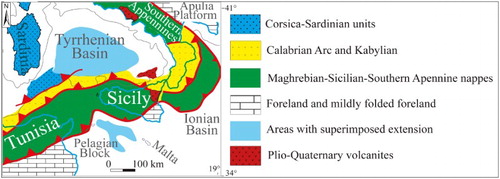
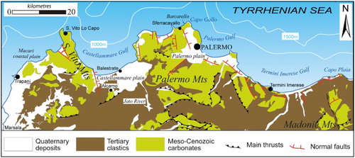
Figure 2. Simplified geological map showing the general distribution of the main lithologies occurring in the NW Sicily FTB.
3. Methodologies
Field mapping was carried out using published base maps (1:10,000 scale map of the Regional Technical Cartography – CTR – Regione Siciliana). Satellite (Google Earth) and aerial images were analysed in order to recognise the main morphostructural features. The geological map is presented at a scale of 1:100,000 in a Transverse Mercator Projection.
The geological mapping was accomplished through a detailed field survey (1:10,000 scale map) performed to collect stratigraphic and lithological data of the mapped UBSUs. Both physical-stratigraphy and facies analysis were applied to several stratigraphic sections in order to define the nature of the unconformities, their stratigraphic relationships (vertical and lateral), and the sedimentological characteristics of the deposits. Microfacies analysis was used to recognise texture and diagenetic features of the hard-rock lithofacies and microfossil content. Photo-geology was useful to define the morphotectonic setting and to classify the different orders of river and marine terraces.
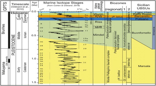
Quaternary deposits were age-constrained using Pleistocene biozonations (CitationCita et al., 2006; CitationRio, Raffi, & Villa, 1990) and numerical age dating obtained from the scientific literature (e.g. CitationHearty, Miller, Stearns, & Szabo, 1986; CitationMauz et al., 1997) compared with the Marine Isotope Stages (MISs) of the δ18O curve (). The global chronostratigraphic units (CitationGibbard, Head, & Walker, 2010) are here integrated with the ‘Italian marine stages’ terminology (see CitationCohen & Gibbard, 2016).
Figure 3. Chronological correlation scheme (modified from CitationBasilone & Di Maggio, 2016), showing temporal distribution of the Sicilian UBSUs and their correlation with isotopic stage, Alpine glaciations, planktonic foraminifer (1: CitationCita et al., 2006) and calcareous nannofossil (2: CitationRio et al., 1990) biozones, mammal faunal complex distribution (CitationBianca et al., 1999; CitationBonfiglio et al., 2008; CitationMasini et al., 2008).
4. The geological map
The Geological Sheet consists of the Main Map and some sketches displaying various geological outputs:
the lithological map (/Geological Sheet) allows us to locate the mapped area within the NW Sicily FTB;
correlation between the logged sections (/Geological Sheet) helps us to understand the stratigraphic setting at a regional scale.
The Geological Map presents the NW Sicily coastal belt from the S. Vito lo Capo peninsula up to the Capo Plaia promontory, across the Gulfs of Castellammare, Palermo, and Termini Imerese. Shaded relief has been used as background for the map to highlight topography. The study area encompasses the northernmost sector of the outcropping Sicilian FTB where the S. Vito, Palermo, Termini, and Madonie mountain complexes are separated by the intervening Castellammare, Palermo, and Termini flat coastal areas, and by deep river valleys. The various orders of the marine or river terrace deposits (i.e. Barcarello, Buonfornello, and Imera synthems) have not been distinguished due to the small scale of the map. Instead, the map highlights the large extent of the unconformity surfaces that record the effect of environmental and sea-level changes due to climatic fluctuations and tectonic movements at regional scale.
4.1. Unconformities and related UBSUs
The main sedimentological and lithological features of the several lithofacies recognised in the mapped UBSUs are reported in and in the legend of the map. In the following, the unconformity surfaces, deposits, and stratigraphic relationships are illustrated ( and ).
Figure 4. Conceptual sketch showing the geometric relationships among unconformity-bounded stratigraphic units of the NW Sicily coastal belt.
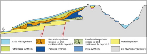
Table 1. Synoptic table summarising stratigraphic and sedimentological features, thicknesses, depositional environments, fossil content, and ages of the Quaternary UBSUs (main references: CitationBonfiglio et al., 2003, Citation2008; CitationBurgio & Fiore, 1997; CitationDi Maggio et al., 2009; CitationDi Stefano & Rio, 1981; CitationHearty et al., 1986; CitationIncarbona et al., 2016; CitationMauz et al., 1997; CitationRuggieri, 1973; CitationRuggieri, Rio, & Sprovieri, 1984).
4.1.1. Unconformity 1 and Marsala synthem
Unconformity 1 is a sharp marine erosional (ravinement) surface cutting the Upper Pliocene sandy marls (see (a)) and the tectonically deformed Meso-Cenozoic carbonates and clastic rocks ((e)). Above this surface, marked by rare erosional channels some metres wide, the Lower Pleistocene marine/coastal deposits (Marsala synthem) lie with onlap (landwards) and downlap (seawards) strata terminations. The unit, with tabular geometry, frequently displays clinostratification. It is well exposed along the flanks of the river valleys crossing the present flat coastal areas. Grey-bluish clays are intercalated mostly along the Palermo plain (Ficarazzi clays). Both in the Balestrate, here indicated as the type section of the unit, and in the Punta Raisi supported sections (/Geological Sheet), it is possible to observe the internal textural and compositional features of the synthem and the characteristics of its lower unconformity (). Colluvial deposits and reworked soils with vertebrate rests of the Monte Pellegrino Faunal Complex are found in a karstic cave at Mount Pellegrino (CitationBurgio & Fiore, 1997) and are believed to pertain to this synthem. On the basis of the fossil content (CitationRuggieri, 1973), the age of the synthem is referred to the Calabrian (Emilian-Sicilian ‘Italian marine stages’, CitationCohen & Gibbard, 2016). The Ficarazzi clays, from detailed study of their biostratigraphic content from the ‘Cava Puleo’ borehole, are dated to upper Calabrian (1.3–0.8 My, CitationDi Stefano & Rio, 1981; CitationBuccheri, 1984). Recent biostratigraphic studies on the clay/calcarenite alternations buried in the Palermo plain suggest a wider chronological interval up to the Middle Pleistocene (between 560 and 540 ka, CitationIncarbona et al., 2016). Numerical age dating carried out on littoral deposits (Thermoluminescence measurements (TL), CitationMauz et al., 1997) shows these deposits as older than the MIS 19 (). The continental deposits were dated to 1.6–0.7 Ma (CitationBonfiglio et al., 2002; CitationMasini, Petruso, Bonfiglio, & Mangano, 2008). Data show that the lower unconformity age is about 1.6–1.5 My and the unit spans between the Upper Calabrian and the early Middle Pleistocene.
Figure 5. Stratigraphy and facies of the coastal-to-marine deposits of the Marsala synthem (MRS). (a) Type section of the MRS measured and sampled along the valley of the Jato River (Balestrate, see index map of /Geological Sheet for location). Legend: (1) Upper Pliocene clays, marls and arenaceous turbidites (BLC); (2) calcareous conglomerates; (3) coarse-to-fine bioclastic sands and clayey sands; (4) well-cemented bioclastic calcarenites; (5) clay siltstone with planktonic foraminifers; (6) marine terrace deposits of the SNP. (b) Intensively bioturbated clayey sands (lower shoreface facies) (Balestrate). (c) Planar-bedded well-cemented calcarenites alternated with massive bioturbated sands (Balestrate). (d) Well-cemented calcarenites rich in pectinids (foreshore facies) (Punta Raisi, see for location). (e) Angular unconformity between the MRS and the deformed Mesozoic carbonates (Mz) and Cenozoic clays (Cz) at the Punta Raisi section (see index map of /Geological Sheet for location).
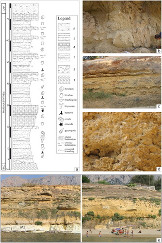
These deposits extensively crop out along the whole coastal belt of NW Sicily, from Marsala to Trabia flat coastal areas, and its offshore (CitationAgate et al., 1993). In the Marsala and Castellammare del Golfo plains (see /Geological Sheet), these deposits, 80 m thick, fill tectonic depressions opening to the sea, and inland they are bordered by wide tectonically controlled relict sea cliffs derived from former fault scarps. In the Palermo plain (/Geological Sheet), they reach 40–50 m of thickness and are mainly represented by bluish clays at the bottom followed upwards by white to yellow calcarenites.
As suggested by the nature of the lower unconformity and the facies of the overlying deposits, tectonics and glacio-eustatic sea-level changes drove the formation of the synthems. The lowermost Pleistocene extensional tectonics produced a differential subsidence, which formed steep fault blocks where the shallow-water sediments, arranged in high-frequency (glacio-eustatic) cycles, accumulated.
4.1.2. Unconformity 2 and Buonfornello synthem
Unconformity 2 is an erosional marine surface (ravinement) carved into the Marsala synthem or older rocks. This surface is overlain by a few metres of thick marine, paralic and continental deposits (Buonfornello synthem). These deposits show a tabular geometry and overlay stepped surfaces of marine terraces (abandoned wave-cut platforms and sea cliffs) occurring at different altitudes (from 10 to 250 m a.s.l.) and frequently marked by red paleosoils. The suggested site to observe the main characteristics of these deposits and of their lower unconformity is around the Termini Imerese-Piano di Imera sector, where some sections have been measured (/Geological Sheet). The marine/coastal sediments laterally pass to coeval continental deposits (colluvium and travertines) mostly outcropping in karstic depressions or abandoned sea caves. Numerical age dating carried out on littoral deposits (TL, CitationMauz et al., 1997) and fossil shells (amino acid epimerisation, CitationHearty et al., 1986) relates these deposits to the Middle Pleistocene sea-level high-stand phases, corresponding to the ‘warm’ MISs between 19 and 7 (). A similar age is confirmed by the fossil content of the heterophic continental deposits belonging to the Paleoloxodon falconeri Faunal Complex (CitationBonfiglio, Di Maggio, Marra, Masini, & Petruso, 2003; CitationMasini et al., 2008). Close to Alcamo village (), fossil remains of this faunal complex are found within travertines covering a marine terrace surface at 250 m a.s.l. (Burgio & Fiore, Citation1997). Radiometric age dating carried out on similar vertebrate deposits in several areas of Sicily suggests an age of 455 ±90 ka (CitationBada et al., 1991; CitationRhodes, 1996). From the above, the age of the lower unconformity is correlatable to MIS 19 and the synthem deposit age is between MISs 19 and 7 ().
Marine terraces and related deposits are discontinuously exposed along the structural lows of the NW Sicily coastal areas, previously filled by the Marsala synthem deposits, which are the result of hundreds of metres tectonic displacement towards the sea sectors (N-wards). They are also exposed along the structural highs corresponding to the remaining uplifted hanging walls of the high-angle extensional faults, where pre-Quaternary rocks crop out. Both regional and tectonic uplift determined widespread emersion with extensive erosion; the interaction between sea-level oscillation (glacio-eustatic cycles) and tectonic uplift is the mechanism generating the unconformities and the marine terrace deposits. Moreover, alternation of arid conditions and wet-warm climate occurred during the Middle Pleistocene was responsible for genesis of colluvial deposits and travertines, respectively.
4.1.3. Unconformity 3 and Imera synthem
Unconformity 3 is a river erosional surface carved on Pleistocene (Marsala and Buonfornello synthems) and pre-Quaternary rocks and covered by pebbly grains, polygenic conglomerates, fluvial channel sands, sandy silt, and clayey silt forming the fluvial deposits of the Imera synthem. These deposits, with tabular geometry, characterise the ancient deposits of most of the NW Sicily river valleys. They hang on along the valley slopes, lying on various orders of river terrace surfaces that are from several metres to one hundred of metres of height with respect to the present-day valley bottom.
Along the younger river terrace deposits, the occurrence of fossil remains of Hippopotamus pentlandi pertaining to the Paleoloxodon mnaidriensis Faunal Complex (CitationBonfiglio et al., 2003; CitationMasini et al., 2008) dates these deposits up to the late Middle Pleistocene and the early Upper Pleistocene. Numerical age dating of the fluvial conglomerates, sampled along a river valley crossing the Castellammare plain, indicates 227 ± 40 ka age (CitationMauz et al., 1997). Rests of mammals of the Paleoloxodon falconeri Faunal Complex (CitationBonfiglio et al., 2003, Citation2008) found along the older river terrace deposits suggest an early Middle Pleistocene age. Therefore, data analysis suggests an early Middle Pleistocene age of the lower unconformity and a Middle-Upper Pleistocene age, up to MIS 5a (CitationBianca, Monaco, Tortorici, & Cernobori, 1999), of the synthem deposits.
The interaction between alluvial deposition and vertical to lateral river erosion, controlled by climatic changes and by the following fluctuations of the river base level, and the downward migration trend of the river base level due to tectonic uplifting, are responsible for the genesis of unconformity 3 and Imera synthem deposits.
4.1.4. Unconformity 4 and Polisano synthem
Unconformity 4 is partly a subaerial erosional surface and, partly, a non-depositional surface topping the younger marine terrace deposits (MIS 7) of the Buonfornello synthem, as well as older rocks. The age of this unconformity is referred to the MIS 6 (). Cross-bedded and cross-laminated aeolian sands and arenites lie on this unconformity forming the main deposits of the Polisano synthem ( and ), which is exposed along the flat coastal areas and at the foot of the bordering slopes. The Macari coastal plain and La Fossa-Gallo Mount sectors are useful sites to observe the main characteristics both of the unit and unconformity 4 (/Geological Sheet and ). Coeval colluvial deposits consisting of breccias and reworked soils, with stone-line structures and mammal rests (Paleoloxodon mnaidriensis Faunal Complex) locally overlay unconformity 4. Based on their fossil content and stratigraphic position (/Geological Sheet), the continental deposits of the Polisano synthem are dated to the Middle Pleistocene (MIS 6) corresponding to the Ionian Stage ().
Figure 6. Stratigraphy and facies of the aeolian sandstones of the Polisano synthem (BLT). (a) Panoramic view of the natural type section of BLT at Macari coastal plain (see /Geological Sheet for location) and lower unconformity (white line) with the marine deposits of the Marsala synthem (MRS). (b) Columnar type section of the Polisano synthem. Legend: (1) Lower Pleistocene calcarenites with pectinids of the Marsala synthem; (2) marine calcarenites and (3) cemented conglomerates of the Buonfornello synthem (SNP); (4) planar- and (5) cross-bedded aeolian sandstones with continental gastropods (BLT); (6) Holocene soils and eluvial deposits of the AFL synthem. (c) Aeolian obstacle dune of BLT, located at the foot of carbonate massif, where planar- and cross-stratification dip seawards (Palmeto Mount, Terrasini, see ). (d) Burrowed reddish aeolian calcareous sandstones forming the basal bed of the BLT stratal succession at the Macari coastal plain. (e) Landward dipping cross-laminated aeolian calcarenites (Macari coastal plain). (f) Ripples and cross-lamination characterising the BLT deposits (Mondello outcropping site, see and Main Map).
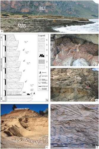
The formation of the subaerial erosional unconformity and the non-depositional surfaces occurred during both sea-level fall and the subsequent lowstand stage. Due to the arid cold climate and the following significant lacking of forest-wood vegetation, rare but intense surface water processes (overland or concentrated flows) and strong wind developed. The water processes produced erosion surfaces and colluvial deposits. The wind flows led to the transport of large amount of sands from the exposed continental platform, following sea-level fall, and their deposition along the coastal areas (forming coastal dunes) up to the foot of the adjoining slopes (forming climbing dunes).
4.1.4. Unconformity 5 and Barcarello synthem
Along the coastal areas, unconformity 5 is a marine abrasion (ravinement) surface, above which coastal/marine deposits with Persististrombus latus onlap the underlying aeolian sands of the Polisano synthem or older rocks; these deposits (Strombus limestone) occur in two orders of marine terraces exposed between 0 and 25 m a.s.l. Landwards, the unconformity is a subaerial erosional surface produced by surficial water overland/concentrated flow and is covered by colluvial deposits (reworked soils and breccias) containing fossil mammals (Paleoloxodon mnaidriensis Faunal Complex). The coastal and continental deposits of the Barcarello synthem () discontinuously crop out along the present-day coastal belt. The Sferracavallo area, where the Barcarello type section was measured, is an excellent site to observe the lithological features of the marine deposits of this synthem and the characteristics of unconformity 5 (/Geological Sheet and ). The warm-temperate ‘Senegalensis fauna’ () and numerical age dating restrict the age of the Barcarello synthem with the last interglacial s.s. (MIS 5, Tyrrhenian, ).
Figure 7. Stratigraphy and facies of the Barcarello synthem (SIT). (a) columnar type section of SIT measured and sampled at Barcarello (see index map of /Geological Sheet for location). Legend: 1. Middle Pleistocene aeolian sands of the Polisano synthem (BLT); 2. very coarse sands and calcarenites with Strombus bubonius; 3. bioclastic coarse-to-fine calcarenites with intercalations of continental scree; 4. very coarse sands and calcarenites with corals, bivalves, gastropods; 5. marine sandy clays; 6. well-cemented stratified slope deposits of the Raffo Rosso synthem (RFR). (b) Cross-laminated bioclastic calcarenites (Sferracavallo, see ). (c) Well-cemented conglomerates and reddish calcarenites with an exemplar of Strombus bubonius (Macari coastal plain). (d) Line drawing of the Sferracavallo natural section (circle in the index map of /Geological Sheet) illustrating different lithofacies and stratigraphic relationships. (e) Reddish calcarenites and breccias (SIT) unconformably covering the Mesozoic carbonates (Mz) at Barcarello outcropping site. (f) Reddish burrowed sands, followed with erosion by well-cemented and laminated foreshore coarse calcarenites (Sferracavallo outcropping site).
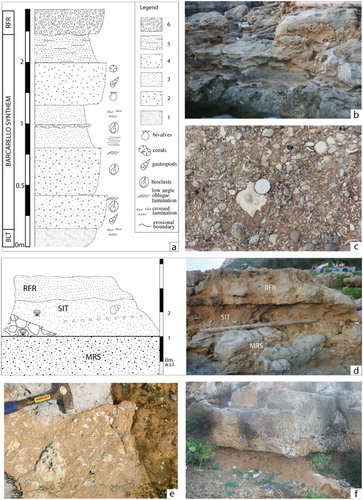
Glacio-eustatic oscillations and tectonic uplift (CitationAntonioli et al., 1999; CitationDi Stefano et al., 2012; CitationSulli, Lo Presti, Gasparo Morticelli, & Antonioli, 2013) controlled the genesis and evolution of coastal unconformity 5 and deposits. Wet-warm climate, when chemical weathering and pedogenetic processes prevailed, favoured soil development. Minor climate oscillations towards arid conditions permitted the development of overland/concentrated flows. The latter processes eroded and transported the unconsolidated soils previously formed and deposited them as colluvial sediments.
4.1.6. Unconformity 6 and Raffo Rosso synthem (RFR)
Unconformity 6 is a subaerial erosional surface marked by paleosoils and/or caliche crusts; above this surface, stratified slope deposits variously cemented and aeolian sands (RFR) downlap the marine lithofacies of the Barcarello synthem or older deposits. Numerical age dating carried out on aeolian sands (TL, CitationMauz et al., 1997) constrains these deposits to the MISs 4–2 (, Tarantian).
The stratified slope deposits ( and ) crop out along the flanks and at the foot of the high-dipping carbonate rock slopes. The Raffo Rosso type section shows the main textural and compositional features of the deposits forming the synthem and the characteristics of unconformity 6 (/Geological Sheet and ). Seawards, crossed stratified quartz and calcareous aeolian sandstones (coastal or climbing dunes), 1–2 m thick, crop out along the flat coastal areas; landwards, 1–7 m thick colluvial deposits with fossil mammals (Pianetti Faunal Complex and Castello Faunal Complex, CitationBonfiglio et al., 2003) dated to the late Upper Pleistocene (CitationBurgio & Fiore, 1997) crop out both in karstic caves and at the foot of the coastal relief.
Figure 8. Stratigraphy and facies of the Raffo Rosso synthem (RFR). (a) Panoramic view of the natural type section of the Raffo Rosso synthem (Capo Gallo, see index map of /Geological Sheet for location). (b) Columnar type section of RFR. Legend: 1. Upper Pleistocene (Tyrrhenian) bioclastic conglomerates and calcarenites of the Barcarello synthem (SIT); 2. mud-supported fine breccias; 3. well-cemented coarse breccias; 4. paleosoils; 5. soil and debrites of the Capo Plaia synthem (AFL); 6. normal (a) and reverse (b) gradational structures. (c) Well-cemented stratified debrites cyclically alternated with mud-supported fine breccias. (d) Paleosoil (pa) interlayered into the well-cemented and stratified breccias (csb). (e) Lower boundary of the Raffo Rosso synthem (RFR), marked by red paleosoil (pa), with the continental lithofacies of the Barcarello synthem (SIT). All the photos come from the Capo Gallo outcropping site (see ).
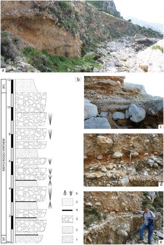
The genesis of unconformity 6 is related to the last glacial period (MISs 4–2), during which subaerial erosion or non-deposition processes affected the relief. During this event, a semi-arid and cold climate promoted strong physical weathering of the rocks (CitationAgnesi et al., 2000), producing slope deposits that were rapidly cemented due to abundant vadose water circulation. Aeolian processes and overland/concentrated flows, leading to the formation of dune deposits and colluvial deposits, respectively, were also favoured by a significant lack of forest-wood vegetation.
4.1.7. Unconformity 7 and Capo Plaia synthem
Unconformity 7 is a paraconformity surface or a subaerial erosional surface where the mostly unconsolidated deposits of the Capo Plaia synthem lie above the stratified and cemented screes of the RFR or older deposits. The Capo Plaia sector is the suggested site to observe the main characteristics of this synthem (see Main Map). The unconformity is related to the sea-level lowstand developed during the last glacial maximum (MIS 2; ). The synthem encompasses all the uppermost Pleistocene-Holocene deposits, widely cropping out along the study area, that were formed during the present interglacial climatic event (MISs 2-1). They display various lithologies from coastal to continental facies () and assume an important multidisciplinary role for geological mapping work, archaeological investigations, and applied sciences (engineers, architecture, geotechnical).
5. Discussion and conclusion
Detailed stratigraphic studies and facies analysis of the marine, paralic, and continental Quaternary deposits allowed for the identification of unconformities and their correlation at a regional scale. This approach was useful for defining and mapping seven UBSUs in the NW Sicily coastal belt.
The various types of unconformities and deposits are related to cyclical erosion-sedimentation processes, which are triggered by the interplay of (i) tectonics (block faulting, regional uplift, and local subsidence), (ii) climate changes (glaciation/deglaciation) and (iii) sea-level oscillations (glacio-eustatic cycles) taking place during the Quaternary (CitationDi Maggio et al., 2009). These factors controlled the morpho-sedimentary evolution of the NW Sicily coastal belt. Tectonics mainly influenced the formation of erosional surfaces (e.g. unconformity 1, Marsala synthem); climate favoured the development of aeolian (e.g. Polisano synthem), colluvial (e.g. Barcarello synthem) or stratified slope (e.g. RFR) deposits; the interplay between glacio-eustatic fluctuations and tectonic uplift controlled the development of coastal/fluvial unconformities and marine/river terrace deposits (e.g. Buonfornello, Imera, and Barcarello synthems). The present-day inner margin elevation of the MIS 5.5 marine terrace (from 2 m up to 29 m a.s.l., CitationAntonioli et al., 2006) suggests that the post-Tyrrhenian uplift rates range between 0.1 and 0.15 m/ka (see also CitationAntonioli et al., 1999; CitationDi Maggio, 2000; CitationMauz et al., 1997).
Software
Using GIS software, we create a geo-database including geo-referenced (datum epsg 32633) vector data related to attitudes, tectonic features, and lithostratigraphy (points, lines, and polygons, respectively). Adobe Illustrator (AI) was used to draft the geological map. Sketches and photos on the Geological Sheet and in the manuscript were adapted using both Adobe Photoshop and AI. Three-dimensional analysis of the topography was performed using Global Mapper.
Quaternary marine and continental Unconformity-Bounded Stratigraphic Units of the NW Sicily coastal belt.pdf
Download PDF (109.6 MB)Acknowledgements
The authors are grateful to Chris Orton, Alessandro Incarbona, and Alastair Clement for their useful comments and suggestions on the manuscript and on the map.
Disclosure statement
No potential conflict of interest was reported by the authors.
ORCID
Mauro Agate http://orcid.org/0000-0002-9861-7601
Luca Basilone http://orcid.org/0000-0002-2719-2984
Related Research Data
References
- Agate, M., Catalano, R., Infuso, S., Lucido, M., Mirabile, L. & Sulli, A. (1993). Structural evolution of the Northern Sicily continental margin during the Plio-Pleistocene. UNESCO reports in marine science 58, 1993. Proceedings of the international scientific meeting “geological development of the Sicilian-Tunisian platform”, Urbino, November 1992, 25–30.
- Agnesi, V., Di Maggio, C., Macaluso, T., Masini, F., Petruso, D., & Simonelli, C. (2000). Quaternary environmental-climatic changes in Sicily. Memorie Società Geologica Italiana, 55, 339–344. Retrieved from http://www.socgeol.net/
- Amato, V., Aucelli, P. P. C., Ciampo, G., Cinque, A., Di Donato, V., Pappone, G., … Ermolli, E. R. (2013). Relative sea level changes and paleogeographical evolution of the southern Sele plain (Italy) during the holocene. Quaternary International, 288, 112–128. doi: 10.1016/j.quaint.2012.02.003
- Antonioli, F., Cremona, G., Puglisi, C., Silenzi, S., Valpreda, E., & Verubbi, V. (1999). Quantitative assessment of post tyrrhenian differential crustal movements in a Mediterranean coastal area (S. Vito-Sicily-Italy). Physics and Chemistry of the Earth, Part A: Solid Earth and Geodesy, 24(4), 343–347. doi: 10.1016/S1464-1895(99)00039-3
- Antonioli, F., Kershaw, S., Renda, P., Rust, D., Belluomini, G., Radtke, U., & Silenzi, S. (2006). Elevation of the last interglacial highstand in Sicily (Italy): A benchmark of coastal tectonics. Quaternary International, 145–146, 3–18. doi: 10.1016/j.quaint.2005.07.002
- Bada, J. L., Belluomini, G., Bonfiglio, L., Branca, M., Burgio, E., & Delitala, L. (1991). Isoleucine epimerization ages of quaternary mammals from Sicily. Il Quaternario, 4(1a), 49–54.
- Basilone, L. (2009). Sequence stratigraphy of a mesozoic carbonate platform-to-basin system in western Sicily. Open Geosciences, 1, 251–273. doi: 10.2478/v10085-009-0021-8
- Basilone, L. (2011). Geological map of the Rocca Busambra-Corleone region (Western Sicily, Italy): Explanatory notes. Italian Journal of Geoscience (Bollettino Società Geologica Italiana), 130, 42–60. doi: 10.3301/IJG.2010.17
- Basilone, L., & Di Maggio, C. (2016). Geology of Monte Gallo (Palermo Mts, NW Sicily). Journal of Maps, 12(5), 1072–1083. doi: 10.1080/17445647.2015.1124716
- Basilone, L., Frixa, A., Trincianti, E., & Valenti, V. (2016). Permian-cenozoic deep-water carbonate rocks of the southern Tethyan domain. The case of central Sicily. Italian Journal of Geosciences, 135, 171–198. doi: 10.3301/IJG.2015.07
- Basilone, L., Lena, G., & Gasparo Morticelli, M. (2014). Synsedimentary-tectonic, soft-sediment deformation and volcanism in the rifted Tethyan margin from the upper triassic–middle Jurassic deep-water carbonates in central Sicily. Sedimentary Geology, 308, 63–79. doi: 10.1016/j.sedgeo.2014.05.002
- Benvenuti, M., & Degli Innocenti, D. (2001). The pliocene deposits in the central-eastern Valdelsa basin (Florence, Italy), revised through facies analysis and unconformity-bounded stratigraphic units. Rivista Italiana Paleontologia e Stratigrafia, 107(2), 265–286.
- Benvenuti, M., Papini, M., & Rook, L. (2001). Mammal biochronology, UBSU and paleoenvironment evolution in a post-collisional basin: Evidence from the late miocene baccinello-cinigiano basin in southern Tuscany, Italy. Bollettino della Società geologica italiana, 120, 97–118.
- Bianca, M., Monaco, C., Tortorici, L., & Cernobori, L. (1999). Quaternary normal faulting in southeastern Sicily (Italy): A seismic source for the 1693 large earthquake. Geophysical Journal International, 139, 370–394. doi: 10.1046/j.1365-246x.1999.00942.x
- Billi, A., Presti, D., Orecchio, B., Faccenna, C., & Neri, G. (2010). Incipient extension along the active convergent margin of Nubia in Sicily, Italy: Cefalù-etna seismic zone. Tectonics, 29, TC4026. doi: 10.1029/2009TC002559
- Bonfiglio, L., Di Maggio, C., Marra, A. C., Masini, F., & Petruso, D. (2003). Bio-chronology of Pleistocene vertebrate faunas of Sicily and correlation of vertebrate bearing deposits with marine deposits. Il Quaternario, 16(1bis), 107–114.
- Bonfiglio, L., Esu, D., Mangano, G., Masini, F., Petruso, D., Soligo, M., & Tuccimei, P. (2008). Late pleistocene vertebrate-bearing deposits at San Teodoro cave (north-eastern Sicily): Preliminary data on faunal diversification and chronology. Quaternary International, 190, 26–37. doi: 10.1016/j.quaint.2007.10.019
- Bonfiglio, L., Mangano, G., Marra, A. C., Masini, F., Pavia, M., & Petruso, D. (2002). Pleistocene Calabrian and Sicilian bioprovinces. Geobios, 35, 29–39. doi: 10.1016/S0016-6995(02)00046-3
- Bonomo, R., & Ricci, V. (2010). Application of the unconformity-bounded stratigraphic units (UBSU) to the geological survey of the volcanic island Ustica (Italy). In G. Groppelli & L. Viereck-Goette (Eds.), Stratigraphy and geology of volcanic areas. Geological Society of America Special Paper 464. Boulder, CO: Geological Society of America. doi:10.1130/2010.2464(03).
- Buccheri, G. (1984). Pteropods as climatic indicators in quaternary sequences: A lower-middle pleistocene sequence outcropping in Cava Puleo (Ficarazzi, Palermo, Italy). Palaeogeography, Palaeoclimatology, Palaeoecology, 45, 75–86. doi: 10.1016/0031-0182(84)90110-X
- Burgio, E., & Fiore, M. (1997). Mustelercta arzilla (De gregorio, 1886) elemento villafranchiano nella fauna di monte pellegrino (Palermo, Sicilia). Il Quaternario, 10(1), 65–74.
- Castellarin, A., Picotti, V., Cantelli, L., Claps, M., Trombetta, L., Selli, L., … Bollettinari, G. (2006). Note illustrative della Carta Geologica d’Italia alla scala 1:50.000. Foglio 080 Riva Del Garda. Progetto Carg. Ispra 1–148.
- Catalano, R., Agate, M., Basilone, L., Di Maggio, C., Mancuso, M., & Sulli, A. (2011). Note illustrative della Carta Geologica d’Italia alla scala 1:50.000, Foglio n. 593 “Castellamare del Golfo” e carta geologica allegata. Progetto Carg. Ispra.
- Catalano, R., Basilone, L., Di Maggio, C., Gasparo Morticelli, M., Agate, M., & Avellone, G. (2013). Note illustrative della Carta Geologica del Foglio n. 594–585 “Partinico-Mondello” (scala 1:50.000) della Carta Geologica D’Italia e carta geologica allegata. Progetto Carg. Ispra.
- Catalano, R., Valenti, V., Albanese, C., Accaino, F., Sulli, A., Tinivella, U., … Giustiniani, M. (2013). Sicily’s fold-thrust belt and slab roll-back: The SI.RI.PRO. Seismic crustal transect. Journal of the Geological Society, 170, 451–464. doi: 10.1144/jgs2012-099
- Chang, K. H. (1975). Unconformity-bounded stratigraphic units. Geological Society of America Bulletin, 86, 1544–1552. doi: 10.1130/0016-7606(1975)86<1544:USU>2.0.CO;2
- Cita, M. B. (2006). New developments in stratigraphic classification. A project of the international subcommission on stratigraphic classification ISSC. Newsletters on Stratigraphy, 42, 69–74. doi: 10.1127/0078-0421/2006/0042-0069
- Cita, M. B., Capraro, L., Ciaranfi, N., Di Stefano, E., Marino, M., Rio, D., … Vai, G. B. (2006). Calabrian and Ionian: A proposal for the definition of Mediterranean stages for the lower and middle pleistocene. Episodes, 29, 107–114. Retrieved from http://www.episodes.org/index.php/epi/index
- Cohen, K. M., & Gibbard, P. L. (2016). Global chronostratigraphical correlation table for the last 2.7 million years, v. 2016a. Cambridge: Subcommission on Quaternary Stratigraphy, International Commission on Stratigraphy. Retrieved from http://www.quaternary.stratigraphy.org.uk/charts/
- Coltorti, M., Melis, E., & Patta, D. (2010). Geomorphology, stratigraphy and facies analysis of some late pleistocene and holocene key deposits along the coast of Sardinia (Italy). Quaternary International, 222, 19–35. doi: 10.1016/j.quaint.2009.10.006
- De Santis, V., Caldara, M., de Torres, T., & Ortiz, J. E. (2010). Stratigraphic units of the Apulian Tavoliere plain (southern Italy): Chronology, correlation with marine isotope stages and implications regarding vertical movements. Sedimentary Geology, 228, 255–270. doi: 10.1016/j.sedgeo.2010.05.001
- Di Maggio, C. (2000). Morphostructural aspects of the central northern sector of Palermo mountains (Sicily). Memorie Società Geologica Italiana, 55, 353–361. Retrieved from http://www.socgeol.net/
- Di Maggio, C., Agate, M., Contino, A., Basilone, L., & Catalano, R. (2009). Unconformity-bounded stratigraphic units of quaternary deposits mapped for the CARG project in northern and western Sicily [unità a limiti inconformi utilizzate per la cartografia dei depositi quaternari nei fogli CARG della sicilia nord-occidentale]. Alpine and Mediterranean Quaternary, 22, 345–364. Open Access.
- Di Maggio, C., Incandela, A., Masini, F., Petruso, D., Renda, P., Simonetti, C., & Boschian, G. (1999). Oscillazioni eustatiche, biocronologia dei depositi continentali quaternari e neotettonica nella sicilia nord-occidentale (penisola di S. Vito Lo capo – trapani). Il Quaternario, 12(1), 25–50.
- Di Stefano, E., Agate, M., Incarbona, A., Russo, F., Sprovieri, R., & Bonomo, S. (2012). Late quaternary high uplift rates in northeastern Sicily: Evidence from calcareous nannofossils and benthic and planktonic foraminifera. Facies, 58(1), 1–15. doi: 10.1007/s10347-011-0271-3
- Di Stefano, E., & Rio, D. (1981). Biostratigrafia a nannofossili e biocronologia del siciliano nella località tipo di ficarazzi. Acta Naturalia Dell’Ateneo Parmense, 17, 97–111.
- Gasparo Morticelli, M., Valenti, V., Catalano, R., Sulli, A., Agate, M., Avellone, G., … Gugliotta, C. (2015). Deep controls on foreland basin system evolution along the Sicilian fold and thrust belt. Bulletin de la Société Géologique de France, 186, 273–290. doi: 10.2113/gssgfbull.186.4-5.273
- Giannandrea, P., Marino, M., Romeo, M., & Schiattarella, M. (2014). Pliocene to quaternary evolution of the Ofanto basin in southern Italy: An approach based on the unconformity-bounded stratigraphic units. Italian Journal of Geosciences, 133, 27–44. doi: 10.3301/IJG.2013.11
- Gibbard, P. L., Head, M. J., Walker, M. J. C., & the Subcommission on Quaternary Stratigraphy. (2010). Formal ratification of the quaternary system/period and the pleistocene series/epoch with a base at 2.58 Ma. Journal of Quaternary Science, 25, 96–102. doi: 10.1002/jqs.1338
- Gugliotta, C., Gasparo Morticelli, M., Avellone, G., Agate, M., Barchi, M. R., Albanese, C., … Catalano, R. (2014). Middle miocene–early pliocene wedge-top basins of NW Sicily (Italy): Constraints for the tectonic evolution of a ‘non-conventional’ thrust belt, affected by transpression. Journal of the Geological Society, 171, 211–226. doi: 10.1144/jgs2013-009
- Hearty, P. J., Miller, G. H., Stearns, C. E., & Szabo, B. J. (1986). Aminostratigraphy of quaternary shorelines in the Mediterranean basin. Geological Society of America Bulletin, 97, 850–858. Retrieved from http://gsabulletin.gsapubs.org doi: 10.1130/0016-7606(1986)97<850:AOQSIT>2.0.CO;2
- Incarbona, A., Contino, A., Agate, M., Bonomo, S., Calvi, F., di Stefano, E., … Priulla, A. (2016). Biostratigraphy, chronostratigraphy and paleonvironmental reconstruction of the Palermo historical centre quaternary succession. Italian Journal of Geosciences, 135, 512–525. doi: 10.3301/IJG.2015.45
- Incarbona, A., Zarcone, G., Agate, M., Bonomo, S., Di Stefano, E., Masini, F., … Sineo, L. (2010). A multidisciplinary approach to reveal the Sicily climate and environment over the last 20.000 years. Central European Journal of Geosciences, 2(2), 71–82.
- Malinverno, A., & Ryan, W. B. F. (1986). Extension in the Tyrrhenian sea and shortening in the Apennines as result of arc migration driven by sinking of the lithosphere. Tectonics, 5, 227–245. doi: 10.1029/TC005i002p00227
- Masini, F., Petruso, D., Bonfiglio, L., & Mangano, G. (2008). Origination and extinction patterns of mammals in three central western Mediterranean islands from the late miocene to quaternary. Quaternary International, 182, 63–79. doi: 10.1016/j.quaint.2007.09.020
- Mauz, B., Buccheri, G., Zöller, L., & Greco, A. (1997). Middle to upper pleistocene morphostructural evolution of the NW-coast of Sicily: Thermoluminescence dating and palaeontological-stratigraphical evaluations of littoral deposits. Palaeogeography, Palaeoclimatology, Palaeoecology, 128, 269–285. Retrieved from http://www.journals.elsevier.com/palaeogeography-palaeoclimatology-palaeoecology/ doi: 10.1016/S0031-0182(96)00033-8
- Murphy, M. A., & Salvador, A. (1999). International stratigraphic guide – an abridged edition. Episodes, 22(4), 255–271.
- Pasquarè, G., Abbate, E., Castiglioni, G. B., Merenda, L., Mutti, E., Ortolani, F., … Sassi, F. P. (1992). Guida al rilevamento e all’informatizzazione della Carta Geologica d’Italia alla scala 1:50.000. Quaderni SGN, serie III, 1, pp. 203.
- Pepe, F., Sulli, A., Agate, M., Di Maio, D., Kok, A., Lo Iacono, C., & Catalano, R. (2003). Plio-Pleistocene geological evolution of the northern Sicily continental margin (southern Tyrrhenian Sea): New insights from high-resolution, multi-electrode sparker profiles. Geo-Marine Letters, 23, 53–63. doi: 10.1007/s00367-003-0124-3
- Rhodes, E. J. (1996). ESR dating on tooth enamel. In B. Basile & S. Chilardi (Eds.), Siracusa, le ossa dei giganti. Lo scavo paleontologico di contrada fusco (pp. 39–44). Siracuse, Italy: Lombardi A. Publishing House.
- Rio, D., Raffi, I., & Villa, G. (1990). Pliocene-Pleistocene calcareous nannofossil distribution patterns in the western Mediterranean. In K. A. Kastens, J. Mascle, C. Auroux, E. Bonatti, C. Broglia, J. Channell, P. Curzi, K.-C. Emeis, G. Glacon, S. Hasegawa, W. Hieke, F. McCoy, J. McKenzie, G. Mascle, J. Mendelson, C. Muller, J.-P. Rehault, A. Robertson, R. Sartori, R. Sprovieri, & M. Torii. Proc. ODP, Sci. Result., 107 (pp. 513–533). College Station, TX.
- Ruban, D. A., Zerfass, H., & Pugatchev, V. I. (2009). Triassic synthems of Southern South America (southwestern Gondwana) and the western Caucasus (the northern Neotethys), and global tracing of their boundaries. Journal of South American Earth Sciences, 28, 155–167. doi: 10.1016/j.jsames.2009.03.003
- Ruggieri, G. (1973). Ostracofauna delle calcareniti bianche quaternarie delle falde (Palermo). Rivista Mineraria Siciliana, 142–144, 160–170.
- Ruggieri, G., Rio, D., & Sprovieri, R. (1984). Remarks on the chronostratigraphic classification of the lower pleistocene. Bollettino della Società geologica italiana, 103, 251–259.
- Sacchi, M., Horvath, F., & Magyari, O. (1999). Role of unconformity-bounded units in the stratigraphy of the continental record: A case study from the late miocene of the western Pannonian basin, Hungary. In B. Durand, L. Jolivet, F. Hovarth, & M. Seranne (Eds.), The Mediterranean basins: Tertiary extension within the Alpine Orogen. Geological Society, London, Special Publications, 156 (pp. 357–390). London: Geological Society. doi: 10.1144/GSL.SP.1999.156.01.17
- Salvador, A. (1987). Unconformity-bounded stratigraphic units. Geological Society of America Bulletin, 98, 232–237. doi: 10.1130/0016-7606(1987)98<232:USU>2.0.CO;2
- Salvador, A. (1994). International Stratigraphic Guide. A guide to stratigraphic classification, terminology and procedure. The International Union of Geological Sciences and the Geological Society of America (Eds.), pp. 214.
- Servizio Geologico Nazionale. (2001). Indicazioni per il rilevamento del Quaternario continentale. Circolare CARG: SGN/2155/U1CARG – 11 maggio 2001.
- Sulli, A., Lo Presti, V., Gasparo Morticelli, M., & Antonioli, F. (2013). Vertical movements in NE Sicily and its offshore: Outcome of tectonic uplift during the last 125 ky. Quaternary International, 288, 168–182. doi: 10.1016/j.quaint.2012.01.021
- Tibaldi, A. (2010). A new geological map of stromboli volcano (tyrrhenian Sea, Italy) based on application of lithostratigraphic and unconformity-bounded units. In G. Groppelli & L. Viereck-Goette (Eds.), Stratigraphy and geology of volcanic areas. Geological Society of America Special Paper 464 (pp. 33–49). Boulder, CO: The Geological Society of America. doi:10.1130/2010.2464(02).
- Vezina, J., Jones, B., & Ford, D. (1999). Sea-level highstands over the last 500,000 years; evidence from the ironshore formation on Grand Cayman, British West Indies. Journal of Sedimentary Research, 69, 317–327. doi: 10.2110/jsr.69.317
- Zavala, C. (2000). Stratigraphy and sedimentary history of the Plio-Pleistocene Sant’Arcangelo basin, southern Apennines, Italy. Rivista Italiana di Paleontologia e Stratigrafia, 106, 399–416.