
ABSTRACT
This paper presents a detailed (1:4000) geomorphological, sedimentological and ecological map of a Mediterranean microtidal wave-dominated beach system and adjacent inner shelf. This map is an innovative cartographic product that integrates a range of processes of present and past timeframes. It is part of a larger cartography on the coastal geomorphology of Sardinia (Italy) aiming to facilitate coastal management practices and future scientific research. The study area is located in SW Sardinia (Italy), and focuses on Porto Pino beach, an important tourist destination of semi-pristine nature, facing environmental pressures common to many coastal Mediterranean settings. In this context, the main human impact on coastal dune habitats is described and a full environmental characterization of the beach system is presented.
1. Introduction
The integrated analysis of socio-ecological values of a coastal system has been regarded as an important approach to facilitate environmental management for coastal conservation (CitationJames, 2000). Large scale mapping is currently being undertaken for the coast of Sardinia to support coastal environmental management (CitationDe Muro, Ibba, & Kalb, 2016; CitationDe Muro, Porta, Passarella, & Ibba, 2017; CitationDe Muro, Pusceddu, Buosi, & Ibba, 2017). These maps represent high-quality tools for the identification, understanding and preservation of coastal processes.
Wave-dominated beaches and adjacent dunes have traditionally been examined as distinct and separate morphodynamic systems (CitationMasselink, Hughes, & Knight, 2011). More recent studies conducted about these co-dependent systems reveal that they often have correlated morphodynamics with strongly coupled sedimentary fluxes (e.g. CitationPeterson et al., 2010; CitationPsuty & Silveira, 2010; CitationSherman & Bauer, 1993; CitationShort & Hesp, 1982). CitationDe Muro and De Falco (2015) described some of the natural processes affecting coastal systems in Sardinia, highlighting the interaction between beach and dune systems. Given the interdependent relationships between these coastal systems, it is appropriate to integrate the geomorphological map of a microtidal wave-dominated embayment such as Porto Pino with information on both beach and dune systems.
The Posidonia dominated meadow of Porto Pino extends between the shoreface and the adjacent inner shelf and its distribution seems to be linked to the geomorphological features observed in both beach to shelf systems. The seagrass meadow supports abundant and diversified benthic biota that contributes to the production of carbonate sediment (CitationPergent, Pergent-Martini, & Boudouresque, 1995; CitationVacchi et al., 2016). This modern biogenic sediment supplies the coastal system and it also provides a well-known beach stability function (CitationDe Falco, De Muro, Batzella, & Cucco, 2011; CitationPusceddu et al., 2011; CitationShort, 2010). The P. oceanica meadow reduces water flow, attenuates wave energy and acts as a barrier to siliciclastic material from the backshore (CitationDe Muro, Batzella, Kalb, & Pusceddu, 2008; CitationDe Muro et al., 2016; CitationDe Muro, Kalb, Ibba, Ferraro, & Ferrara, 2010). Consequently, an integrated beach management approach has to take into account the mapping of seagrass distribution and ensure its conservation is maintained in future planning strategies (CitationDe Muro & De Falco, 2015; CitationTecchiato, Collins, Parnum, & Stevens, 2015).
This paper aims to (1) discuss the application of integrated geomorphological, sedimentological and ecological mapping for coastal management; (2) describe the overall beach system from backbeach to inner shelf and associated processes (sediment transport pathways, distribution of morpho-sedimentological features, identification of sediment facies and benthic habitats); and (3) describe the anthropogenic impacts on the Porto Pino dune system through the Dune Vulnerability Index (DVI; CitationGarcía Mora, Gallego Fernández, Williams, & García Novo, 2001; CitationWilliams et al., 2001). Dune vulnerability is defined as the loss of capacity of a dune system to return to its original dynamic equilibrium after system displacement. The DVI is based on a range of parameters derived from coastal and dune geomorphology, but also includes the identification of sediment sources, transport and sedimentation pathways and the mapping of terrestrial habitats and associated morpho-sedimentological features. The Main Map presented in this paper is a mixed geomorphological, sedimentological and ecological map summarizing both static and dynamic processes in a single cartographic output. This map is a useful new tool for the comprehension of coastal processes and it facilitates the understanding of dune vulnerability estimates by presenting all the components of the system used to calculate DVIs. This DVI in turn facilitate the conservation of dune habitats by informing coastal managers of current anthropogenic impact.
2. Regional settings
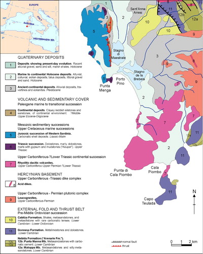
Porto Pino beach is a 5 km long NW–SE-oriented microtidal wave-dominated embayment located in SW Sardinia (Italy, Mediterranean Sea; ). The geological basement () consists of leucogranites and acid dikes, together with rhyolitic and dacitic volcanites of the Palaeozoic. Mesozoic deposits are composed of dolostones and bioclastic limestones mainly outcropping at Punta Menga in the NW sector of the embayment (CitationCarmignani, Oggiano, Funedda, Contia, & Pasci, 2015; CitationCostamagna & Barca, 2002). Ancient marine deposits (coastal to littoral conglomerates, sandstones and biocalcarenites – Pleistocene) and marine to continental deposits (Holocene) also outcrop locally.
Figure 1. Geological scheme of the study area (from CitationCarmignani et al., 2015, adapted).
The dune system of Porto Pino beach is bounded to the N by marsh and lagoonal deposits.
A sporadic stream in the central sector of Porto Pino beach supplies sediment from the hills and coastal plain to the bay.
The beach is naturally protected to the NW by Carloforte and Sant’Antioco islands and to the SE by Capo Teulada (). Prevalent wave exposure angles range between 274° and 176° ((d)), and the main geographical fetches ((d)) are 243°–274° (500 km long) and 176°–243° (220 km long). The southern continental shelf region of western Sardinia is subject to extreme wave energy, with swell wave heights >3.0 m and periods >7 s.
Figure 2. (a) Geographical setting of the study area. (b) Southern region of Sardinia with location of the Buoy of Cagliari-Capo Boi (RON – Rete Ondametrica Nazionale), Porto Pino beach and Carloforte weather station (RMN Station – Rete Mareografica Nazionale). (c) North-western region of Sardinia with location of the Alghero Buoy (RON). (d) Wave exposure angles of Porto Pino beach (E: direction, H: main direction; Qr: longshore transport per unit time to the right of an observer situated onshore and looking seaward; Ql: longshore transport per unit time to the left of an observer located onshore and looking seaward). (e) Carloforte weather data (RMN Station; Hs: significant wave height; T: wave period; Tp: peak wave period). (f) Wind data (RMN Station – Carloforte). (g) Distribution of wave heights and directions (RON Buoy – Cagliari-Capo Boi). (h) Distribution of wave heights and directions (RON Buoy – Alghero).
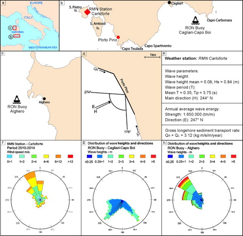
The prevailing winds in summer and winter are NNW and NW, with the latter being more intense than the former ((f)). Westerly winds are directly related to storms from the NW and occasionally reach high intensity. Considering wave exposure angles, the prevailing wave direction is mainly linked to events from the W, SW and S more specifically between the angles of 176° and 274° ((g,h)). Thus, for the identification of wave parameters (Hs – significant wave height and Tp – peak wave period), we referred to swell wave climate derived from data recorded at two locations. The Alghero buoy situated in NW Sardinia was used for the sector between 243° N and 274° N and the Cagliari-Capo Boi buoy located in SE Sardinia for the sector between 176° N and 243° N.
3. Methods
The integrated geological, geomorphological, sedimentological and marine-coastal dynamic studies were carried out following the methodological protocols and standards tested and developed by the Coastal and Marine Geomorphology Group of the University of Cagliari (CitationBartole & De Muro, 2012; CitationBatzella et al., 2011; CitationBrambilla, van Rooijen, Simeone, Ibba, & De Muro, 2016; CitationDe Muro, Batzella, De Falco, & Porta, 2010; CitationDe Muro, Pusceddu, & Kalb, 2010; CitationDe Muro, Kalb, Pusceddu, & Ibba, 2013). To facilitate understanding of the text it is important to outline that the map of Porto Pino beach (Main map) includes one detailed map and three inset maps: (Map 1) morpho-sedimentological (1:4000 scale, central map); (Map 2) topographic, bathymetric and geomorphological profiles (1:20,000 scale, top right); (Map 3) sedimentary facies (1:20,000 scale, central right); and (Map 4) sediment sampling grid (1:20,000 scale, bottom right). A geodetic network was established to acquire data using known points. Topographic/bathymetric data were collected using DGPS (Differential Global Positioning System) in a GNSS (Global navigation satellite system) and/or StarFire (Navcom SF3040) system.
3.1. Backshore
Topographic surveys and shoreline position were recorded four times over one year (autumn 2014, winter 2015, spring 2015 and summer 2015) along 28 transects ∼150 m spaced and extended from backshore to the shoreline (Map 2).
Fifty-seven sediment samples were collected using a small corer along these transversal transects (Map 4) in March 2015 distributed along dune crest, backshore and intertidal beach zone. The chronological reconstruction of the geomorphological evolution of several features of the backshore (dune areal extent, shoreline position, vegetation cover, rocky outcrops, artificial and hydrographic features) is based on the interpretation of orthophotos and aerial photographs observed in optical stereoscopic vision ().
Coastal dunes are classified into two types following CitationMasselink et al. (2011): (a) primary dunes (foredune and embryo dunes) found closest to the shoreline and significantly affected by wave processes, and (b) secondary dunes (mature foredune ridges, blowouts and transgressive dunes), located further inland and dissociated from wave processes through coastal progradation.
The landward limit of run-up was measured with a DGPS receiver during a storm event which resulted in a dominant wave direction from the SW. Dune system mapping is based on the interpretation of orthophotos and a 2008 Digital Elevation Model with spatial and vertical resolution of 20 cm integrated with geomorphological surveys.
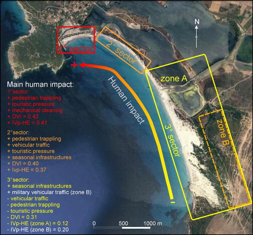
The main human impacts on the backshore were analyzed () as part of a coastal dunes’ vulnerability assessment carried out using the DVI (CitationDe Muro et al., 2011; CitationGarcía Mora et al., 2001; CitationWilliams et al., 2001). The DVI is based on 57 variables that describe the Partial Index Vulnerability (IVp) related to the geomorphological condition (GCD), marine influence (MI), aeolian influence (AI), vegetation condition (VC), and human effects (HE). IVp are calculated by summation of variables ranking within each variable class, expressed as a percentage of the total vulnerability. A DVI is calculated as the average of the five partial vulnerability indices, the IVps. The DVI and each IVp index range between 0 (low vulnerability) and 1 (high vulnerability), and, as the index increases, the ability of the dune system to withstand further interventions decreases. According to CitationGarcía Mora et al. (2001) and CitationWilliams et al. (2001) four groups of dune with different vulnerability based on DVI values can be identified: low (DVI < 0.25), from low to medium (between 0.25 and 0.5), from medium to high (between 0.5 and 0.6) and high vulnerability (DVI > 0.6). IVp-HE describes dune alteration over time by temporary and permanent human activities, such as: agriculture, afforestation, pastoral farming, sand mining, development, infrastructure and direct and indirect effects of tourism.
Figure 3. Schematic representation of main human impacts on dune habitats. The three sectors selected for the analysis are also outlined.
3.2. Shoreface
Twenty-eight single beam bathymetry transects spaced ∼150 m apart were surveyed from shoreline to inner shelf (up to 15 m in depth; Map 2) four times per year (autumn 2014, winter 2015, spring 2015 and summer 2015). Based on aerial photos and orthophotos from different years (Appendix 1), a repetition of morphodynamic beach states (cfr.CitationWright & Short, 1984) with different positions of bar axis and troughs was identified. This repetition was also observed in bathymetric profiles collected through field surveys. On the main map, bar axis and trough positions were represented as shown on satellite images related to a metocean event (April 2013), with dominant wave direction from the SW.
Seventy-six sediment samples from the shoreface–inner shelf were collected using a Van Veen grab (5 dm3 capacity) along the single beam transects (Map 4) in March 2015. Several scuba diving surveys were performed in the intermattes and along the upper limit of P. oceanica meadow in June 2015.
A side-scan sonar mosaic provided by Ministero dell'Ambiente e della Tutela del Territorio (CitationVV, 2002), was used to identify and map the acoustic facies. These were verified through scuba diving, underwater video data and sediment sampling with the final aim of generating a sedimentary facies and benthic habitat map (Map 3).
3.3. Sediment analysis
The grain-size analyses were performed following the American Society for Testing and Materials international standard methodology. The >63 μm fraction was dry sieved through sieves spaced at ¼ phi (ø) per unit (CitationWentworth, 1922). The <63 μm fractions were analyzed using the pipette sedimentation method (CitationFolk, 1974; CitationFolk & Ward, 1957). Textural classification was calculated following the CitationFolk and Ward (1957) protocols. Sediment mineralogical composition was established using the areal comparison method (CitationLewis & McConchie, 1994) through visual estimates under optical microscope in order to distinguish quartz + feldspars, micas, other minerals, lithoclasts and skeletal grains. The Dietrich-Fruhling calcimeter was used to determine the percentage of calcium carbonate.
Sediment facies were identified following a classification commonly used in Sardinia (CitationDe Falco et al., 2011; CitationDe Muro et al., 2016; CitationLecca, De Muro, Cossellu, & Pau, 2005).
3.4. Hydrodynamic models
Topographic–bathymetric profiles, sediment grain-size and benthic habitat data collected through field surveys were used as background information to determine the following hydrodynamic parameters: wave forcing, current speed and direction. The hydrodynamic modeling was carried out with the open source DELFT3D software (Deltares http://oss.deltares.nl/web/delft3d) with associated WAVE and FLOW modules. Significant wave height (HS), peak period (Tp), wind direction (Carloforte weather station 2010–2014), directional spreading, JONSWAP Peak enhancement factor and bottom friction (JONSWAP) were set prior to performing modeling operations.
Data recorded from a fixed buoy (Cagliari-Capo Boi Buoy 2010–2014) were classified in five storm categories (weak, moderate, significant, severe and extreme) based on wave energy to show the most energetic wave climate events. The three most energetic wave events (S, SW and W) were identified following the CitationMendoza and Jiménez (2005) classification and compared with data from the NOAA (National Oceanic and Atmospheric Administration) hindcast dataset. Consequently, wave forcing, current speed and direction were modeled for each of the identified wave events (S, SW and W). Despite rare wind and wave conditions from the S, they were incorporated in the modeling because they are intense and significant for the redistribution of sediments along the shoreline, resulting in anti-clockwise beach rotation towards the NW. Hydrodynamic models were calibrated through real-time measurements of wave refraction angles recorded on the shore face for each of the modeled conditions. Ripple migration was also measured in the field following each of the modeled metocean events through scuba diving surveys along previously recorded single beam echo sounder transects.
4. Results
4.1. Dune zone and human impact
The northern sector of the embayment shows a narrow primary dune (foredune and embryo) and secondary dunes stabilized by Pinus halepensis (pine tree). In the southern sector of the embayment, primary dunes alternate with dune slacks and deflation areas, and are bordered by a secondary dune system colonized by Juniperus (juniper). The southernmost part of Porto Pino beach has military constraints and is characterized by a complex system of secondary dunes (transgressive, parabolic and blowouts). In this sector, primary dunes mainly consist of foredunes and embryo dunes with Ammophila arenaria (European marram grass). Vegetation increases landward seem to induce an evolution from barchanoid dunes to parabolic dunes, also observed in Israel, Canary Islands, etc. (CitationHernández-Cordero, Hernández-Calvento, & Pérez-Chacón Espino, 2015; CitationTsoar & Blumberg, 2002).
In order to evaluate human impact on the dune zone, the Porto Pino embayment was divided in three sectors (). The first sector, about 600 m long, is characterized by the highest human pressure within Porto Pino Bay. Tourists generate pedestrian traffic on the foredunes impacting the local vegetation and the removal of beach wrack from the backshore also damages the beach system, resulting in sediment compaction and alteration of the natural beach morphology. The DVI is 0.42 in this sector () and indicates low-medium vulnerability, whereas the IVp related to the HE (human effect) is 0.41.
The second sector of the studied area () is about 1500 m long and is characterized by a complex dune system. Vehicle transit on primary dunes contributes to vegetation degradation. Deflation processes are triggered by pedestrian transit on secondary dunes and the development of infrastructure on the foredunes. In this sector, deflation processes are mostly due to the placement and removal of café and restaurant kiosks at the beginning and end of each tourist season. These human pressures/threats have significant effects on dune habitats, however DVI = 0.40 and IVp-HE = 0.37 indicate low-medium vulnerability.
The third and southernmost sector includes a military area. This sector is about 3000 m long with a wide transgressive dune system, and can be subdivided into two zones (A and B, ). Zone A includes the foredunes, with a low human impact and the lowest IVp-HE value (0.12) measured for the studied area. Zone B is characterized by the impact of tanks and trucks used during military exercises (Map 1). These activities cause vegetation degradation on the secondary dunes resulting in an IVp-HE value of 0.20 for this zone.
4.2. Underwater geomorphology and benthic habitats
Bathymetric profiles ( and Map 1) show a complex system of submerged sand bars alternating with troughs located 300 m from the shoreline and up to 4 m deep. Further offshore, the sea-bottom gently slopes down to −10 m (about 500–600 m from the shoreline).
Figure 4. (A) Location of shoreface profiles in (B). (B) Cross-shore profiles showing geomorphological features, submerged bars and troughs at Porto Pino.
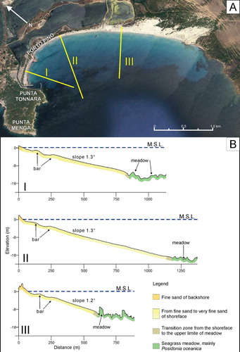
Three main benthic habitats and substrate types were identified (Map 1): (1) uncolonized sandy substrate, (2) rocky outcrops and (3) P. oceanica meadow. Uncolonized sandy substrates dominate the seafloor between the shoreline and the upper limit of seagrass meadow. The distribution of phanerogam meadow is shore parallel and occupies a sandy substratum between −15 m (upper limit) and −35 m (lower limit). The intermattes were observed in the central and NW zones and near the lower limit of the meadow, whereas rocky substrates are situated near the coastline in the NW and SE regions of the studied area.
4.3. Sedimentary facies
Four sand-dominated facies were identified in the studied area (Map 3, ). Facies A extends between 0 and 10 m depth and is mostly siliciclastic fine sand. Facies B is a mixed bioclastic and siliciclastic gravelly sand (27% bioclasts; 68% quartz + feldspars) mapped between 1 and 12 m depth, corresponding to the shoreface and the shallower limit of P. oceanica meadow. Facies C consists of biogenic gravelly sand (Appendix 2) mapped between 12 and 30 m depth. Facies C was sampled within the patches of uncolonized sandy substrate occurring within the P. oceanica meadow also known as ‘intermattes’. Facies D consists of bioclastic gravelly sand (about 50% bioclasts) and was mapped at 30–35 m depth below the lower limit of the P. oceanica meadow.
4.4. Hydrodynamics and morphodynamic beach state
Three main coastal current scenarios (associated with three different wave directions: S, SW and W; ; ) are described using sedimentological, morphodynamic and hydrodynamic data (wind, waves and currents).
Figure 5. Wave (A) and hydrodynamic (B) model induced by wind blowing from the S; wave (C) and hydrodynamic (D) model induced by wind blowing from the SW; wave (E) and hydrodynamic (F) model induced by wind blowing from the W.
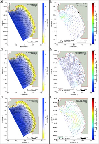
Wind and waves from the S generate a NNW-oriented longshore current with a magnitude of 0.5 m/s ((B)). The resulting surf zone is not strictly structured, with visible bars and troughs close to the shore.
Wind and waves from the SW produce a shore-parallel, northwards-oriented longshore current and a SSW-oriented rip current in the NW sector of the beach with a magnitude of 0.5 m/s ((D)). As a result, different bar and through systems were observed within the Porto Pino embayment. A complex bar and trough system extends 300 m cross-shore in the SE sector of the embayment, whilst a simple longshore bar and trough (LBT) zone (100 m wide cross-shore) is visible in the NW sector.
Lastly, wind and waves from the W generate a NW-oriented longshore current and a SSW-oriented rip current in the NW sector of the beach with a magnitude of 0.5 m/s ((F)). The surf zone linked to this scenario affects the zone between the filled artificial mouth of the lagoon (Map 1) and the SE limit (up to 300 m wide). In each of the modeling scenarios sediment transport occurs mainly from SE to NW.
The three described scenarios regulate the morphodynamic beach state (sensu CitationShort, 1979) at Porto Pino, varying periodically and alongshore from LBT to Rhythmic Bar and Beach (RBB), Transverse Bar and Rip (TBR) and Low Tide Terrace beach (LTT). This morphological variation of the surf zone visible along the Porto Pino embayment is described below for the three sectors outlined in .
LBT prevails in the first sector of the beach during the whole year. The westernmost zone of the 2° sector (about 500 m long) ranges from LBT (weaker storms) to RBB (stronger storm) during winter due to increased intensity and storm frequency, and can be classified as LBT during summer. The south-easternmost zone of the 2° sector up to the river mouth in the 3° sector varies from RBB (weaker storms) to TBR (stronger storm) during winter and is characterized by a RBB state during summer. Finally, the southernmost section of the 3°sector is classified as TBR (in winter) and RBB (in summer). LTT was also noted in summer between the second and third sectors.
5. Discussion
The complex interaction of aeolian, sedimentological, ecological, hydrodynamic and anthropogenic processes on the coast of Porto Pino is summarized in the Main Map. These processes include event-scale longshore and rip currents responsible for the position of sand bars, as well as decadal-scale aeolian processes determining primary and secondary dune formation.
outlines previous research published in the Journal of Maps on coastal geomorphological mapping occasionally accompanied by benthic habitat, hydrodynamic modeling and/or sedimentological data. The Main Map presented herein is the first map summarizing dune vulnerability data as well geomorphological, benthic habitat, hydrodynamic and sedimentological data. In fact, within the map elements used to describe dunes the following are directly related to dune vulnerability: surface of deflation, erosion scarp, grooves due to pedestrian and vehicle impact, fragmentation of dune habitats, landward limit of run-up and washover fan. The applications of this cartography to coastal management include: (i) facilitation of coastal vulnerability assessment, (ii) baseline study for the future assessment of anthropogenic impacts and (iii) monitoring of environmental changes. For example, the distribution and extension of rip and longshore currents seawards controls the distribution of the P. oceanica meadow’s upper limit. The concurrent mapping of a dynamic (rip and longshore currents) and a relatively static (P. oceanica meadow upper limit) feature on Map 1 allows the integration of these processes to be visualized, understood and maintained in the long term.
Table 1. Comparison of previous publications with a similar focus published in the Journal of Maps.
Another important outcome of this comprehensive land–sea mapping is the identification of offshore sediment transport pathways contributing to the variability of shoreface geomorphological features, which also directly relates to dune stability. In particular the presence of bioclastic components with a clear marine origin in dune samples was used as a tracer of sediment transport from the seagrass meadow to the dune system.
The main anthropogenic pressures are linked to the direct or indirect effects of tourism (human trampling, recreational activities and seasonal infrastructure on the foredune). The deposition of beach wrack (or seagrass berm) is detrimental for tourism and consequently it is removed by mechanical cleaning generating an additional impact on the backshore, as the trucks transiting on the beach flatten the berms and reduce sand permeability (CitationDe Muro & De Falco, 2015; CitationSimeone, De Falco, Como, Olita, & De Muro, 2008; CitationSimeone, De Muro, & De Falco, 2013). Generally, in semi-exposed and open beaches seagrass berms do not remain in the backshore when storm waves reach the coast and show a more dynamic behavior resulting in a reduced or negligible protective role (CitationGómez-Pujol, Orfila, Álvarez-Ellacuría, Terrados, & Tintoré, 2013). In contrast, a sheltered beaches like Porto Pino, seagrass berms remain at the backshore for long periods contributing to beach protection (CitationCarruthers et al., 2007; CitationDe Falco et al., 2008, Citation2014).
Various human practices are responsible for fragmentation of dune habitats, degradation of vegetation cover and local over-wash events (1° and 2° sectors, ). The results also indicate the lowest degree of vulnerability occurs in the southernmost part of the studied embayment where tourist activities are limited (3° sector, Zone A, ). The use of tanks and trucks during military exercises is evident on the secondary dunes of the 3° sector (Zone B, ). In this sector, military constraints protect primary dunes from the impact of tourism, because access and transit are denied. At the same time, vehicle transit damages the secondary dune, causing vegetation fragmentation.
Comparison of Italian and Australian management strategies for coastal conservation is a current research theme by the authors and includes the comparison of beach usage at Porto Pino and Esperance Bay (SW Australia; CitationTecchiato, Buosi, Ibba, Ryan, & De Muro, 2016). Future research aims to develop guidelines for environmental managers using an intercontinental research approach, which will further build on the data presented herein for Porto Pino.
6. Conclusions
The map of Porto Pino beach integrates marine and coastal data providing an overview of the complex interaction of a variety of sedimentological, geomorphological and hydrodynamic processes. This product constitutes a useful and innovative tool for long-term monitoring and management of coastal ecosystems because it informs environmental authorities of the present benthic habitat distribution, sediment transport pathways and human-use of the coast.
Software
Reson PDS2000 was used for the acquisition of the bathymetric data. ESRI ArcGIS 10.0 was used to create a georeferenced topographic–bathymetric base map and to depict the granulometric distribution of the sediment. Textural sediment classification and grain-size parameters were obtained using Gradistat (CitationBlott & Pye, 2001). Global Mapper 14 was used to produce a land–sea digital terrain model. The final map was produced using Adobe Illustrator CS5.
Comprehensive Geomorphological and Sedimentological Mapping and Applications for Coastal Management: Porto Pino, SW Sardinia, Western Mediterranean.zip
Download Zip (6.3 MB)Acknowledgements
This study forms part of the LIFE ‘SOSS DUNES’ (Safeguard and management of South-western Sardinian Dunes) project (LIFE13NAT/IT/001013). The authors are also grateful to Marco Porta for map revision.
Disclosure statement
No potential conflict of interest was reported by the authors.
Additional information
Funding
Related Research Data
References
- Bartole, R., & De Muro, S. (2012). Acoustic facies and seabed features of the mixed carbonate-siliciclastic deposits of the last eustatic cycle in the la Maddalena Archipelago (North Sardinia, Italy). Italian Journal of Geosciences, 131(1), 102–122. 10.3301/IJG.2011.28
- Batzella, T., Pusceddu, N., Kalb, C., Ferraro, F., Ibba, A., & De Muro, S. (2011). Bars/troughs dynamics and evolution trend of the la Cinta beach (San Teodoro OT) - NE Sardinia. Rendiconti Online Società Geologica Italiana, 17, 17–23. doi: 10.3301/ROL.2011.13
- Biolchi, S., Furlani, S., Covelli, S., Busetti, M., & Cucchi, F. (2016). Morphoneotectonics and lithology of the eastern sector of the Gulf of Trieste (NE Italy). Journal of Maps, 12(5), 936–946. doi: 10.1080/17445647.2015.1099572
- Biolchi, S., Furlani, S., Devoto, S., Gauci, R., Castaldini, D., & Soldati, M. (2016). Geomorphological identification, classification and spatial distribution of coastal landforms of Malta (Mediterranean Sea). Journal of Maps, 12(1), 87–99. doi: 10.1080/17445647.2014.984001
- Blott, S. J., & Pye, K. (2001). GRADISTAT: A grain size distribution and statistics package for the analysis of unconsolidated sediments. Earth Surface Processes and Landforms, 26(11), 1237–1248. doi: 10.1002/esp.261
- Bracchi, V. A., Marchese, F., Savini, A., Chimienti, G., Mastrototaro, F., Tessarolo, C., … Corselli, C. (2016). Seafloor integrity of the Mar Piccolo Basin (Southern Italy): quantifying anthropogenic impact. Journal of Maps, 12, 1–11. doi: 10.1080/17445647.2016.1152920
- Brambilla, W., van Rooijen, A., Simeone, S., Ibba, A., & De Muro, S. (2016). Field observations, coastal video monitoring and numerical modeling at Poetto Beach, Italy. Journal of Coastal Research, Special Issue, 75, 825–829. doi: 10.2112/SI75-166.1
- Carmignani, L., Oggiano, G., Funedda, A., Contia, P., & Pasci, S. (2015). The geological map of Sardinia (Italy) at 1:250,000 scale. Journal of Maps, 12, 826–835. doi: 10.1080/17445647.2015.1084544
- Carruthers, T. J. B., Dennison, W. C., Kendrick, G. A., Waycott, M., Walker, D. I., & Cambridge, M. L. (2007). Seagrasses of south–west Australia: A conceptual synthesis of the world's most diverse and extensive seagrass meadows. Journal of Experimental Marine Biology and Ecology, 350, 21–45. doi: 10.1016/j.jembe.2007.05.036
- Chiocci, F. L., Romagnoli, C., Casalbore, D., Sposato, A., Martorelli, E., Alonso, B., … Tempera, F. (2013). Bathy-morphological setting of Terceira Island (Azores) after the FAIVI cruise. Journal of Maps, 9(4), 590–595. doi: 10.1080/17445647.2013.831381
- Costamagna, L. G., & Barca, S. (2002). The ‘Germanic’ Triassic of Sardinia (Italy): A stratigraphic, depositional and paleogeographic review. Rivista Italiana di Paleontologia e Stratigrafia, 108-1, 67–100. doi: 10.13130/2039-4942/5455
- Darvill, C. M., Stokes, C. R., Bentley, M. J., & Harold, L. (2014). A glacial geomorphological map of the southernmost ice lobes of Patagonia: the Bahía Inútil – San Sebastián, Magellan, Otway, Skyring and Río Gallegos lobes. Journal of Maps, 10(3), 500–520. doi: 10.1080/17445647.2014.890134
- De Falco, G., Budillon, F., Conforti, A., De Muro, S., Di Martino, G., Innangi, S., … Simeone, S. (2014). Sandy beaches characterization and management of coastal erosion on western Sardinia Island (Mediterranean Sea). Journal of Coastal Research, 70, 395–400. doi: 10.2112/SI70-067.1
- De Falco, G., De Muro, S., Batzella, T., & Cucco, A. (2011). Carbonate sedimentation and hydrodynamic pattern on a modern temperate shelf: The strait of Bonifacio (western Mediterranean). Estuarine, Coastal and Shelf Science, 93, 14–26. doi: 10.1016/j.ecss.2011.03.013
- De Falco, G., Simeone, S., Solinas, G., Batzella, T., Cancemi, G., Cancemi, M., & De Muro, S. (2008). Shoreline retreat and Posidonia oceanica banquette removal in the beach of Paragan (Southern Corse) [ Arretramento della linea di riva e rimozione delle banquette di Posidonia oceanica nella spiaggia di Paragan (Corsica meridionale)]. Rendiconti Online Società Geologica Italiana, 3(1), 296–297.
- De Muro, S., Batzella, T., De Falco, G., & Porta, M. (2010). Sedimentological map of Bonifacio Strait inner shelf. Rendiconti Online Società Geologica Italiana, 11(2), 752–753.
- De Muro, S., Batzella, T., Kalb, C., & Pusceddu, N. (2008). Sedimentary processes, hydrodynamics and modeling of the beaches of Santa Margherita, Solanas, Cala di Trana and La Sciumara (Sardinia – Italy) [ Processi sedimentari, idrodinamica e modellizzazione delle spiagge di Santa Margherita, Solanas, Cala di Trana e La Sciumara (Sardegna - Italia)]. Rendiconti Online Società Geologica Italiana, 3(1), 308–309.
- DeMuro, S., Brambati, A., Tecchiato, S., Porta, M., & Ibba, A. (2017). Geomorphology of marine and transitional terraces and raised shorelines between Punta Paulo and Porvenir, Tierra del Fuego, Straits of Magellan-Chile. Journal of Maps, 13(2), 311–321. doi: 10.1080/17445647.2017.1295406
- De Muro, S., & De Falco, G. (2015). Handbook of best practices for the study, monitoring and management of Sardinian beaches. Cagliari: University press – Scienze Costiere e Marine, CUEC Editrice. ISBN 978-88-8467-953-6
- De Muro, S., Di Grande, A., Brambati, A., & Ibba, A. (2015). Geomorphology map of the marine and transitional terraces and raised shorelines of the Península Juan Mazía, Tierra Del Fuego. Straits of Magellan – Chile. Journal of Maps, 11(5), 698–710. doi: 10.1080/17445647.2014.970592
- De Muro, S., Ibba, A. & Kalb, C. (2016). Morpho-sedimentology of a Mediterranean microtidal embayed wave dominated beach system and related inner shelf with Posidonia oceanica meadows: The SE Sardinian coast. Journal of Maps, 12(3), 558–572, doi: 10.1080/17445647.2015.1051599
- De Muro, S., Kalb, C., Ibba, A., Batzella, T., Pusceddu, N., Ferrara, C., & Ferraro, F. (2011). Coastal dunes vulnerability. GAVAM checklist method used at three Mediterranean microtidal wave dominated beaches (Gulf of Cagliari). Rendiconti Online Società Geologica Italiana, 17, 77–82. doi: 10.3301/ROL.2011.26
- De Muro, S., Kalb, C., Ibba, A., Ferraro, F., & Ferrara, C. (2010). Sedimentary processes, morphodynamics and sedimentological map of ‘Porto Campana’ SCI beaches (Domus De Maria - SW Sardinia). Rendiconti Online Societa Geologica Italiana, 11(2), 754–755.
- De Muro, S., Kalb, C., Pusceddu, N., & Ibba, A. (2013). The activity of ‘Osservatorio Coste E Ambiente Naturale Sottomarino’ (OCEANS) and the implementation of a monitoring network and study methodology for sedimentological and morphodynamic processes of Mediterranean microtidal wave-dominated beaches (Sardinia). In L. E. Cipriani (Ed.), Coastal erosion monitoring. A network of regional observatories. Results from ResMar project (pp. 95–109). Firenze: Regione Toscana.
- De Muro, S., Porta, M., Passarella, M., & Ibba, A. (2017). Geomorphology of four wave-dominated microtidal Mediterranean beach systems with Posidonia oceanica meadow: a case study of the Northern Sardinia coast. Journal of Maps, 13(2), 74–85. doi: 10.1080/17445647.2016.1259593
- De Muro, S., Pusceddu, N., Buosi, C., & Ibba, A. (2017). Morphodinamics of a Mediterranean microtidal wave-dominated beach: Forms, processes and insights for coastal management. Journal of Maps, doi: 10.1080/17445647.2016.1250681
- De Muro, S., Pusceddu, N., & Kalb, C. (2010). Sedimentological map of the seafloor between Porto Pozzo Bay and Capo Ferro – NE Sardinia. Rendiconti Online Società Geologica Italiana, 11(2), 756–757.
- Devoto, S., Biolchi, S., Bruschi, V. M., Furlani, S., Mantovani, M., Piacentini, D., … Soldati, M. (2012). Geomorphological map of the NW Coast of the Island of Malta (Mediterranean Sea). Journal of Maps, 8(1), 33–40. doi: 10.1080/17445647.2012.668425
- Evans, W., Benetti, S., Sacchetti, F., Jackson, D. W. T., Dunlop, P., & Monteys, X. (2015). Bedforms on the northwest Irish Shelf: indication of modern active sediment transport and over printing of paleo-glacial sedimentary deposits. Journal of Maps, 11(4), 561–574. doi: 10.1080/17445647.2014.956820
- Faccini, F., Piccazzo, M., & Robbiano, A. (2008). Environmental geological maps of San Fruttuoso Bay (Portofino Park, Italy). Journal of Maps, 4(1), 431–443. doi: 10.4113/jom.2008.1018
- Folk, R. L. (1974). The petrology of sedimentary rocks. Austin, Tex: Hemphill.
- Folk, R. L., & Ward, W. (1957). Brazos river bar: A study in the significance of grain size parameters. Journal of Sedimentary Petrology, 27(1), 3–26. doi: 10.1306/74D70646-2B21-11D7-8648000102C1865D
- Forte, F., & Pennetta, L. (2007). Geomorphological Map of the Salento Peninsula (southern Italy). Journal of Maps, 3(1), 173–180. doi: 10.1080/jom.2007.9710836
- García Mora, M. R., Gallego Fernández, J. B., Williams, A. T., & García Novo, F. (2001). A coastal dune vulnerability classification. A case of study of the SW Iberian Peninsula. Journal of Coastal Research, 17, 802–811.
- Gómez-Pujol, L., Orfila, A., Álvarez-Ellacuría, A., Terrados, J., & Tintoré, J. (2013). Posidonia oceanica beach-caster litter in Mediterranean beaches: A coastal videomonitoring study. In D. C. Conley, G. Masselink, P. E. Russell, & T. J. O’Hare, (Eds.), Proceedings 12th International Coastal symposium (Plymouth, England). Journal of Coastal Research, Special Issue, No. 65 (pp. 1768–1773). ISSN 0749-0208
- Graciotti, R., Pantaloni, M., & Foresi, L. (2008). Geomorphological map of the Pianosa Island (Tuscan Archipelago, Italy). Journal of Maps, 4(1), 463–471. doi: 10.4113/jom.2008.1025
- Gregoire, G., Ehrhold, A., Le Roy, P., Jouet, G., & Garlan, T. (2016). Modern morpho-sedimentological patterns in a tide-dominated estuary system: the Bay of Brest (West Britanny, France). Journal of Maps, 12(5), 1152–1159. doi: 10.1080/17445647.2016.1139514
- Hättestrand, C., & Clark, C. D. (2006). The glacial geomorphology of Kola Peninsula and adjacent areas in the Murmansk Region, Russia. Journal of Maps, 2(1), 30–42. doi: 10.4113/jom.2006.41
- Hernández-Cordero, A. I., Hernández-Calvento, L., & Pérez-Chacón Espino, E. (2015). Relationship between vegetation dynamics and dune mobility in an arid transgressive coastal system, Maspalomas, Canary Islands. Geomorphology, 238, 160–176. doi: 10.1016/j.geomorph.2015.03.012
- Hernández-Santana, J. R., Méndez-Linares, A. P., López-Portillo, J. A., & Preciado-López, J. C. (2016). Coastal geomorphological cartography of Veracruz State, Mexico. Journal of Maps, 12(2), 316–323. doi: 10.1080/17445647.2015.1016128
- Isola, I., Bini, M., Ribolini, A., Pappalardo, M., Consoloni, I., Fucks, E., … Zanchetta, G. (2011). Geomorphologic map of northeastern sector of San Jorge Gulf (Chubut, Argentina). Journal of Maps, 7(1), 476–485. doi: 10.4113/jom.2011.1203
- Isola, I., Bini, M., Ribolini, A., Zanchetta, G., & D’Agata, A. L. (2017). Geomorphology of the Ceyhan river lower plain (Adana Region, Turkey). Journal of Maps, 13(2), 133–141. doi: 10.1080/17445647.2016.1274684
- James, R. J. (2000). From beaches to beach environments: Linking the ecology, human-use and management of beaches in Australia. Ocean & Coastal Management, 43(6), 495–514. doi: 10.1016/S0964-5691(00)00040-5
- Karymbalis, E., Gaki-Papanastassiou, K., Tsanakas, K., & Ferentinou, M. (2016). Geomorphology of the Pinios River delta, Central Greece. Journal of Maps, 12, 12–21. doi: 10.1080/17445647.2016.1153356
- Karymbalis, E., Papanastassiou, D., Gaki-Papanastassiou, K., Tsanakas, K., & Maroukian, H. (2013). Geomorphological study of Cephalonia Island, Ionian Sea, Western Greece. Journal of Maps, 9(1), 121–134. doi: 10.1080/17445647.2012.758423
- Lecca, L., De Muro, S., Cossellu, M., & Pau, M. (2005). I sedimenti terrigeno-carbonatici attuali della piattaforma continentale del Golfo di Cagliari. Il Quaternario (Italian Journal of Quaternary Science), 18(2), 201–221.
- Lewis, D. W., & McConchie, D. (1994). Practical sedimentology. New York, NY: Chapman & Hall.
- Luca, F., Robustelli, G., Conforti, M., & Fabbricatore, D. (2011). Geomorphological map of the Crotone Province (Calabria, South Italy). Journal of Maps, 7(1), 375–390. doi: 10.4113/jom.2011.1190
- Masselink, G., Hughes, M., & Knight, J. (2011). Introduction to Coastal Processes and Geomorphology. 2nd ed. London: Hodder Education.
- Mendoza, E. T., & Jiménez, J. A. (2005). Factors controlling vulnerability to storm impacts along the Catalonian coast. Coastal Engineering 2004, 3087-3099. Proceedings of the 29th International Conference National Civil Engineering Laboratory, Lisbon, Portugal, 19–24 September 2004. ISBN: 978-981-256-298-2, doi: 10.1142/9789812701916_0249
- Miccadei, E., Orrù, P., Piacentini, T., Mascioli, F., & Puliga, G. (2012). Geomorphological map of the Tremiti Islands (Puglia, Southern Adriatic Sea, Italy), scale 1:15,000. Journal of Maps, 8(1), 74–87. doi: 10.1080/17445647.2012.668765
- Pennetta, M., Brancato, V. M., De Muro, S., Gioia, D., Kalb, C., Stanislao, C., … Donadio, C. (2016). Morpho-sedimentary features and sediment transport model of the submerged beach of the ‘Pineta della foce del Garigliano’ SCI Site (Caserta, southern Italy). Journal of Maps, 12, 139–146. doi: 10.1080/17445647.2016.1171804
- Pergent, G., Pergent-Martini, C., & Boudouresque, C.F. (1995). Utilisation de l’herbier a Posidonia oceanica comme indicateur biologique de la qualité du milieu littoral en Méditerranée: état des connaissances. Mésogée, 54, 3–27.
- Peterson, C. D., Stock, E., Hart, R., Percy, D., Hostetler, S. W., & Knott, J. R. (2010). Holocene coastal dune fields used as indicators of net littoral transport: West Coast, USA. Geomorphology, 116, 115–134. doi: 10.1016/j.geomorph.2009.10.013
- Psuty, N. P., & Silveira, T. M. (2010). Global climate change: An opportunity for coastal dunes?? Journal of Coastal Conservation, 14, 153–160. doi: 10.1007/s11852-010-0089-0
- Pusceddu, N., Batzella, T., Kalb, C., Ferraro, F., Ibba, A., & De Muro, S. (2011). Short-term evolution of the Budoni beach on NE Sardinia (Italy). Rendiconti Online Società Geologica Italiana, 17, 155–159. doi: 10.3301/ROL.2011.45
- Robustelli, G., Lucà, F., Corbi, F., Fubelli, G., Scarciglia, F., & Dramis, F. (2009). Geomorphological Map of the Ionian area between the Trionto and Colognati River catchments (Calabria, Italy). Journal of Maps, 5(1), 94–102. doi: 10.4113/jom.2009.1044
- Rovere, A., Casella, E., Vacchi, M., Parravicini, V., Firpo, M., Ferrari, M., … Bianchi C. N. (2015). Coastal and marine geomorphology between Albenga and Savona (NW Mediterranean Sea, Italy). Journal of Maps, 11(2), 278–286. doi: 10.1080/17445647.2014.933134
- Rovere, A., Ferraris, F., Parravicini, R., Navone, A., Morri, C., & Bianchi, C. N. (2013). Characterization and evaluation of a marine protected area: ‘Tavolara – Punta Coda Cavallo’ (Sardinia, NW Mediterranean). Journal of Maps, 9(2), 279–288. doi: 10.1080/17445647.2013.778081
- Rovere, A., Parravicini, V., Vacchi, M., Montefalcone, M., Morri, C., Bianchi, C. N., & Firpo, M. (2010). Geo-environmental cartography of the marine protected area ‘Isola di Bergeggi’ (Liguria, NW Mediterranean Sea). Journal of Maps, 6(1), 505–519. doi: 10.4113/jom.2010.1137
- Sabato, L., Longhitano, S. G., Gioia, D., Cilumbriello, A., & Spalluto, L. (2012). Sedimentological and morpho-evolution maps of the ‘Bosco Pantano di Policoro’ coastal system (Gulf of Taranto, southern Italy). Journal of Maps, 8(3), 304–311. doi: 10.1080/17445647.2012.722791
- Sherman, D. J., & Bauer, B. O. (1993). Dynamics of beach-dune systems. Progress in Physical Geography, 17, 413–447. doi: 10.1177/030913339301700402
- Short, A. D. (1979). Three dimensional beach-stage model. The Journal of Geology, 87, 553–571. doi: 10.1086/628445
- Short, A. D. (2010). Sediment transport around Australia – sources, mechanisms, rates, and barrier forms. Journal of Coastal Research, 26(3), 395–402. doi: 10.2112/08-1120.1
- Short, A. D., & Hesp, P. A. (1982). Wave, beach and dune interactions in southeastern Australia. Marine Geology, 48, 259–284. doi: 10.1016/0025-3227(82)90100-1
- Simeone, S., De Falco, G., Como, S., Olita, A., & De Muro, S. (2008). Dinamica deposizionale delle banquettes di Posidonia oceanica nelle spiagge. Rendiconti Online Della Società Geologica Italiana, 3, 726–727.
- Simeone, S., De Muro, S., & De Falco, G. (2013). Seagrass berm deposition on a Mediterranean embayed beach. Estuarine, Coastal and Shelf Science, 135, 171–181. doi: 10.1016/j.ecss.2013.10.007
- Spagnolo, M., & Clark, C. D. (2009). A geomorphological overview of glacial landforms on the Icelandic continental shelf. Journal of Maps, 5(1), 37–52. doi: 10.4113/jom.2009.1049
- Tecchiato, S., Buosi C., Ibba, A., Ryan, D. A., & De Muro, S. (2016). A comparison of geomorphic settings, sediment facies and benthic habitats of two carbonate systems of western Mediterranean Sea and south Western Australia: Implications for coastal management. Journal of Coastal Research, Special Issue, 75, 562–566. doi: 10.2112/SI75-113.1
- Tecchiato, S., Collins, L., Parnum, I., & Stevens, A. (2015). The influence of geomorphology and sedimentary processes on benthic habitat distribution and littoral sediment dynamics: Geraldton, Western Australia. Marine Geology, 359, 148–162. doi: 10.1016/j.margeo.2014.10.005
- Tonielli, R., Innangi, S., Budillon, F., Di Martino, G., Felsani, M., Giardina, F., … Filiciotto, F. (2016). Distribution of Posidonia oceanica (L.) Delile meadows around Lampedusa Island (Strait of Sicily, Italy). Journal of Maps, 12, 249–260. doi: 10.1080/17445647.2016.1195298
- Tsoar, H., & Blumberg, D.G. (2002). Formation of parabolic dunes from barchan and transverse dunes along Israel’s Mediterranean coast. Earth Surface Processes and Landforms, 27, 1147–1161. doi: 10.1002/esp.417
- Vacchi, M., De Falco, G., Simeone, S., Montefalcone, M., Morri, C., Ferrari, M., & Bianchi, C. N. (2016). Biogeomorphology of the Mediterranean Posidonia oceanica seagrass meadows. Earth Surface Processes and Landforms. doi: 10.1002/esp.3932
- VV, A. A. (2002). Mappatura delle Praterie di Posidonia oceanica lungo le coste della Sardegna e delle piccole Isole circostanti. Relazione Finale Volumi 1 e 2. Ministero dell'Ambiente e della Tutela del Territorio - Servizio Deifesa del Mare.
- Wentworth, C. K. (1922). A scale of grade and class terms for clastic sediments. Journal of Geology, 30, 377–392. doi: 10.1086/622910
- Williams, A. T., Alveirinho-Dias, J., Garcia-Novo, F., García-Mora, M. R., Curr, R., & Pereira, A. (2001). Integrated coastal dune management: Checklists. Continental Shelf Research, 21, 1937–1960. doi: 10.1016/S0278-4343(01)00036-X
- Wright, L. D., & Short, A. D. (1984). Morphodynamic variability of surf zones and beaches: A synthesis. Marine Geology, 56, 93–118. doi: 10.1016/0025-3227(84)90008-2