
ABSTRACT
This paper presents a geological map and cross-section of the Falcón Basin based both on published and unpublished work and on new data collected in the northern and southern basin margins. The geological map covers an area of 4600 km2 at 1:100,000 scale. The cross-section is oriented NNW-SSE, traversing perpendicular to the main structures. In general, the structure of the study area results from the inversion of a graben (Oligocene-early Miocene back-arc basin), that started in the middle Miocene due to the convergence between the Caribbean and South American plates. The map, the cross-section and the observations made in the field have been used to generate a tectonostratigraphic reconstruction of the Falcón Basin. The Oligocene-early Miocene sedimentary succession mapped and described is relevant to the hydrocarbon exploration in the Caribbean and in the Gulf of Venezuela, where new hydrocarbon resources have recently been discovered (i.e. Perla gas field).
1. Introduction
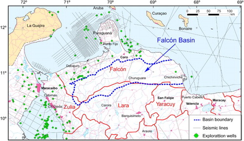
The Falcón Basin extends over most of Falcón State, the northern states of Lara and the Yaracuy and eastern part of Zulia in northwestern Venezuela (), covering about 26,000 km2. The most active geologic investigation of the Falcón Basin took place between 1912 and 1980 related to petroleum exploration of the region. During this period, 200 exploratory wells were drilled and more than 12,000 km of seismic lines were acquired (CitationBoesi & Goddard, 1991). Early geological exploration focused on the coastal plain of northwestern Venezuela and proximal offshore areas, whereas the interior of Falcón State remains poorly studied (). The compilation works by CitationGonzález de Juana (1938), CitationMacellari (1995), CitationMuessig (1984a), CitationPorras (2000), CitationSenn (1935) and CitationZambrano, Vásquez, Duval, Latraille, and Coffinieres (1971) integrated the geological knowledge that resulted from this exploration period. Another important contribution concerning the stratigraphy of the Falcón Basin is that published by CitationWheeler (1963), which was built on the exploration campaigns carried out by geologists from Creole Petroleum Corporation over 10 years. These reports include the first geological cartography of Falcón State in a series of 1:100,000 and 1:50,000 scale unpublished maps. All subsequent geological mapping of this region has been based upon the Creole Petroleum Corporation geological cartography. The biostratigraphic framework of the Falcón Basin was produced by CitationDíaz de Gamero (1977, Citation1989), based on planktonic foraminifera.
Figure 1. Political map of northwestern Venezuela indicating the approximate situation of the Falcón Basin (dot line), the limits of Venezuela states, the seismic lines and the exploration wells drilled since 1912. Note that the Maracaibo and the coastal Falcón region, including the offshore areas, have been extensively explored, whereas the interior Falcón state remains poorly studied.
The geological map of the Falcón Basin presented herein aims to contribute to the understanding of the sedimentary and structural evolution of the basin, which experienced a main phase of subsidence in the Aquitanian-Burdigalian (23–16 Ma) followed by an episode of tectonic inversion in the Langhian-Messinian (16–5 Ma) associated with oblique convergence of the Caribbean and South American plates. This contribution is the result of 4 years field work in the Falcón Basin, with new data collected on the northern and southern basin margins, and the revision of previously unpublished and published works. We present a new 1:100,000 scale geological map of the basin, with accompanying structural models. The map, which is partly built on previous geological maps of the area (e.g. CitationRohr et al., 1962; CitationRohr, Cross, & Natera, 1964), documents new structural features (formerly unidentified faults and folds), and improves the cartographic accuracy of the lithostratigraphic units mapped. Further new contributions include age revisions of the lithostratigraphic units exposed in the northern and southern Falcón Basin based on larger foraminifera occurrences, lithostratigraphic correlations and a tectonostratigraphic reconstruction of the basin. This geological synthesis provides updated and novel basic information for further insights into the different factors controlling the evolution of the southern Caribbean basins during Cenozoic times.
2. The mapping area
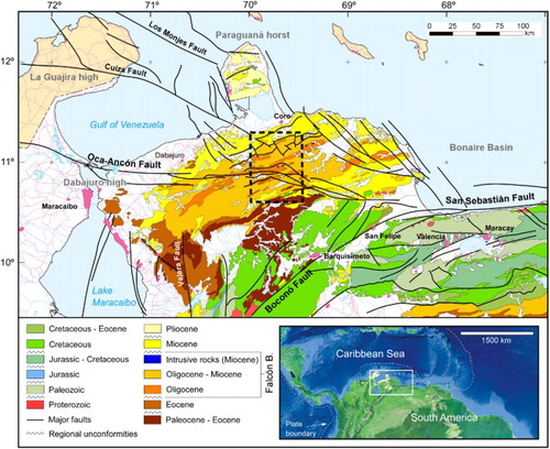
The Falcón Basin also referred as the ‘Falcón Anticlinorium’ is an inverted graben represented by WSW-ENE trending fold and thrust belt (see cross-section A-A’ on the Main Map) (CitationBaquero et al., 2009). The basin is bounded in the north by the Paraguaná horst () and in the south by the deformed belt of the Mérida-Lara Andes (Boconó Fault System). The western limb of the basin is the Dabajuro-Guajira high (CitationMacellari, 1995). The preserved limits of the basin are marked by the cartographic expression of a late Eocene to early Oligocene regional unconformity () (CitationBoesi & Goddard, 1991). The sedimentary record of the Falcón Basin comprises Oligocene to early Miocene strata with alkaline basaltic intrusions of early Miocene age emplaced along the central basin axis (CitationMuessig, 1984a, Citation1984b). The sedimentation is progressively younger towards the basin margins (), displaying an onlapping character.
Figure 2. Simplified geological map of northwestern Venezuela with the major chronostratigraphic units indicated (modified from CitationHackley, Urbani, Karlsen, & Garrity, 2005). Note that the Falcón Basin is filled by Oligocene-Miocene materials bounded by two major regional unconformities. The dot-lined square indicates the study area. The inset map at the lower right corner shows the location of the study area in northwestern South America.
The development and evolution of the Falcón Basin is a result of polyphasic tectonics along the convergence zone between the Caribbean and South American plates (). These tectonic events are reflected in the thicknesses and facies evolution of the sedimentary succession cropping out in the mapping area. Three major tectonic-induced Transgressive–Regressive sequences bounded by regional unconformities were identified (), which coincide with the depositional cycles established by CitationMacellari (1995) in the southwestern Caribbean basins of Venezuela and Colombia.
Figure 3. Left: Kinematic model proposed by CitationEscalona and Mann (2011) for the obliquely convergent Caribbean-South America margin and the evolution of the different depocenters. Right: Paleogeographic evolution of the Caribbean-South America margin during the Cenozoic based on CitationPindell et al. (2005). The study area is designated by a star. The different tectonic sequences described in this work were situated in the different depocenters: TS1: Tectonic Sequence 1; TS2: Tectonic Sequence 2; TS3: Tectonic Sequence 3. Thick arrows on the corners indicate the inferred relative motion of the Caribbean Plate. The present-day coastline of northwestern Venezuela and the relative position of the Maracaibo Lake, the Paraguaná and the Guajira peninsulas in each tectonic stage are also indicated.
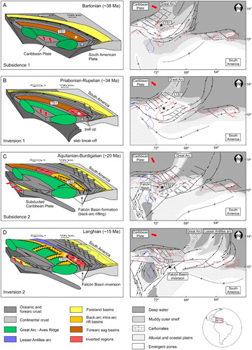
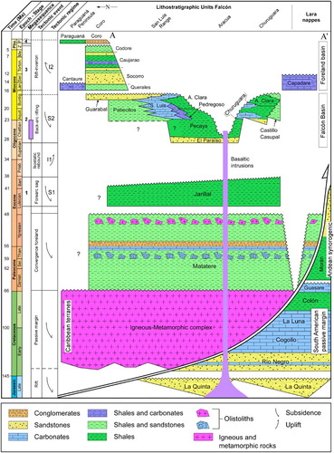
Figure 4. Jurassic to Pliocene lithostratigraphy of the Falcón Basin depicting the major tectonic-induced depositional sequences, the main tectonic events and the tectonic regime.
2.1. Sequence 1
Sequence 1 is composed of a Lutetian to Bartonian (48–38 Ma) siliciclastic succession interpreted by CitationEscalona and Mann (2011) as deposited into a forearc sag basin, prior to the formation of the Falcón Basin ((A)). Sequence 1 strata are considered the substrate of the Falcón Basin. This sequence unconformably overlies the Paleocene to middle Eocene flysch succession of the Matatere Formation in the southern part of the Falcón Basin. These flysch strata were deposited in a foreland basin, formed during the initial convergence between the South American passive margin and the Caribbean volcanic arc (CitationEscalona & Mann, 2011).
2.2. Sequence 2
Sequence 2 deposits unconformably overlie Sequence 1, which was uplifted and eroded during the Priabonian-early Rupelian (38–31 Ma) inversion stage ((B)) (CitationEscalona & Mann, 2011). Sequence 2 is composed of a late Rupelian to Burdigalian (31–16 Ma) series of continental to deep marine strata filling the Falcón Basin, associated with a back-arc rifting behind a northeast-southwest trending subduction zone involving the South American and Caribbean plates ((C)) (CitationAudemard, 1993, Citation1995; CitationEscalona & Mann, 2011; CitationMann, 1999; CitationPorras, 2000).
2.3. Sequence 3
Sequence 3 comprises a Langhian to Messinian (16–5 Ma) siliciclastic and carbonate succession deposited into a foredeep setting as a consequence of tectonic inversion of the Falcón Basin ((D)). During this compressional episode, the reactivation of pre-existent normal faults caused the formation of an east–west trending fold belt and the generation of a foreland basin to the north (see cross-section A-A’) (CitationBaquero et al., 2009; CitationBoesi & Goddard, 1991; CitationEscalona & Mann, 2011; CitationGorney et al., 2007; CitationMacellari, 1995). The tectonic inversion of the basin implied the subaerial exposure of the Oligocene-early Miocene sedimentary units.
3. Methods
A digital geological map covering 4600 km2 of the Falcón Basin was generated using Esri ArcMap. This map resulted from the compilation and interpretation of global positioning system (GPS) data from field geostations, geological field mapping, ancient Creole Petroleum Corporation geological maps (CitationRohr et al., 1962, Citation1964) and Landsat seven satellite imagery. The topographic shaded relief was generated from the Shuttle Radar Topography Mission 90 m digital elevation model, originally provided by the NASA, and available online through the CGIAR Consortium for Spatial Information. Physical data such as roads, rivers and urban areas were redrafted from satellite images and 1:100,000 scale topographic maps published by CitationDirección de Cartografía Nacional de Venezuela (1969). The World Geodetic System 1984 (WGS 1984) was used as a reference system and geodetic datum for the map projection which is UTM Zone 19N. Geologic data collected during field mapping were positioned using a Trimble Nomad GPS receiver. The use of the Esri ArcPad application enabled the collection of point data (waypoints containing geologic information), linear data (geologic contacts, fold-hinge lines, faults and tracks) and polygon data (outcropping geologic units) into a geographic information system (GIS). The location of geologic contacts was based on visual interpretation of geomorphological features identified in the satellite images combined with the GIS geodatabase generated in the field. Structural features such as faults and folds were identified by the analysis of geologic-plane orientations and permitted the establishment of structural domains. The topographic and historic geologic maps used were previously digitalized and georeferenced using Global Mapper.
A digital cross-section (A-A’) was created by the projection at depth of surface geological data (see the Main Map). The cross-section was constructed using the kink method (CitationCoates, 1945), orthogonally traversing the main tectonic structures. The A-A’ cross-section was restored at the top of the syn-rift deposits of Sequence 2 (early Miocene) using Canvas software. The contractional structures of the Lara Nappes were generated prior to the Oligocene-early Miocene extensional episode and are therefore not restored (see restored section A-A’). The A-A’ restored section was generated by the use of the simple shear algorithm. The compaction effects have not been considered for restoration.
4. Mapping units
The lithostratigraphic units cropping out in the mapping area include igneous, metamorphic and sedimentary rocks spanning from the Early Cretaceous to the early Pliocene. These lithostratigraphic units are represented in and described below.
4.1. Lara Nappes
In the southern part of the mapping area a series of intensively deformed igneous and metamorphic rocks of Early to Late Cretaceous age crop out (), which constitute the Lara nappes (CitationBellizzia, 1986; CitationBushman, 1959; CitationStephan, 1982; CitationVon Der Osten, 1967). These rocks include ophiolites of the proto-Caribbean oceanic crust and low grade metamorphic rocks of marine affinity, including slates, phyllites and metasandstones (CitationStephan, 1982). The Lara nappes overthrusted onto the South American autochthonous terranes during Paleocene-late Eocene times (CitationBaquero et al., 2009; CitationEscalona & Mann, 2011).
La Luna Formation () is represented by fault-bounded successions of mudstones to fine-grained packstones interbedded within black-shales cropping out in the southern part of the mapping area. The carbonate levels are rich in radiolarians, planktonic foraminifera, pyrite and organic matter, indicating a pelagic marine environment with recurrent anoxic/dysoxic conditions. The La Luna Fm. was deposited during the Cenomanian to Campanian (100–72 Ma) (CitationDe Romero & Galea-Alvarez, 1995; CitationLiddle, 1946; CitationRenz, 1959; CitationSutton, 1946) over the continental shelf and the north-trending seaway in the passive margin of South America, and overthrusted during the emplacement of the Lara Nappes.
The thrusted and folded Matatere Formation crops out extensively in the southern part of the mapping area unconformably overlying the Cretaceous igneous-metamorphic rocks. This unit is composed of a late Paleocene to early Eocene flysch succession of shales with abundant intraformational breccias and extraformational boulder beds containing metamorphic rocks, granite and Cretaceous limestones (La Luna and Cogollo formations) () (CitationVon Der Osten & Zozaya, 1957). The turbidite succession of the Matatere Fm. registered an important regression with the development of a carbonate platform dominated by Lithothamnium and larger foraminifera, followed by transgressive conglomeratic sandstones containing pebbles recycled from the previous platform carbonates (CitationJames, 2005).
The Capadare Formation is part of Sequence 3 (), and corresponds to a syn-orogenic succession deposited during the tectonic inversion of the Falcón Basin. It constitutes foredeep strata characterized by an alternation of coralline algal limestones, shales and minor sandstones cropping out at the front of the south-verging flank of the inverted Falcón Basin (see cross-section A-A’). This inverted graben was the source area of siliciclastic sediments and some reworked skeletal fragments. The carbonates also contain Amphistegina, Miosorites, Annulosorites, echinoids, fragments of gastropods and bivalves, and scattered rhodoliths. The age of this unit was established by CitationWheeler (1959) as middle Miocene based on planktonic foraminifera assemblages.
4.2. Southern Falcón Basin
The Jarillal Formation corresponds to the Sequence 1 deposits outcropping in the southern mapping area (), and constitutes the Falcón Basin substrate. The lower limit of the Jarillal Fm. is an angular unconformity topping the Matatere flysch strata. This unit is dominated by a succession of dark gray basin-shales with minor carbonate levels. Locally, shales are rich in glauconite, pyrite and gypsum. The fauna described by CitationWheeler (1963) in the type section include planktonic and microbenthic foraminifera of Eocene age. Based on the analysis of palynomorph assemblages, CitationHunter (1974) and CitationPitelli and Molina (1989) established the age of the Jarillal Fm. as middle to late Eocene.
The Castillo and Casupal formations constitute the deposits of Sequence 2 at the southern margin of the Falcón Basin (), which locally onlap the Eocene Jarillal Fm., the Paleocene-Eocene Matatere Fm. and the igneous-metamorphic complex. This contact corresponds to a regional angular unconformity, which can be mapped along the southern Falcón and northern Lara states. Towards the north, the Castillo and Casupal formations interfinger with the Churuguara and Agua Clara marine shales (). The Castillo and Casupal formations are mapped as a unique cartographic unit due their facies similarities and time equivalence. This cartographic unit is composed of sandstones, conglomerates, shales, lignites and limestones deposited in near-shoreline transitional environments, including continental to shallow-marine zones. These facies are rich in gastropods, bivalves, larger foraminifera, microbenthic foraminifera and coralline algae. Based on larger foraminifera associations, CitationWheeler (1963) attributed the Castillo and Casupal formations to the late Oligocene-early Miocene. However, the presence of Miosorites americanus and Annulosorites spiralis near the base of the Casupal Fm. in the mapping area restricts the age of this unit to the early Miocene (CitationAlbert-Villanueva, 2016; see also CitationBanerjee, Yemane, & Johnson, 2000; CitationBouDagher-Fadel, 2008; CitationButterlin, 1981; CitationHottinger, 2001; CitationSeiglie, 1982; CitationSeiglie, Grove, & Rivera, 1977; CitationSerra-Kiel, Ferràndez-Cañadell, García-Senz, & Hernaiz Huerta, 2007).
The Churuguara Formation is included in Sequence 2 and crops out in the southern part of the Falcón Basin along a south-verging fold and thrust belt. This unit unconformably overlies the Eocene Jarillal Fm. (), locally onlapping a subaerial unconformity characterized by well-developed paleosoils or indurated highly bioturbated surfaces of ravinement. Towards the south, the Churuguara Fm. interfingers with the siliciclastic strata of Castillo and Casupal formations, whereas in the north it is bounded by a thrust fault (see cross-section A-A’). The Churuguara Fm. contains two carbonate banks with larger foraminifera, coralline algae and corals separated by siliciclastic marine deposits. The siliciclastic deposits make up a succession of basin-shales and turbidites with glaucony-sand beds rich in planktonic foraminifera. The platform-carbonate banks thin and pass southwards and eastwards into the pelagic shales and turbidite succession, whereas in the west they interfinger with shallow-marine siliciclastics. The isolated carbonate banks were developed upon submarine fault-bounded paleohighs striking parallel to the southern basin margin, whereas the turbidite succession was deposited to the south, into an east–west marginal depocenter. The carbonate banks of the Churuguara Fm. are capped by subaerial unconformities (sensu CitationCatuneanu, 2006). The Churuguara Fm. is characterized by an early Miocene larger foraminifera association including Lepidocyclina favosa/undosa, Lepidocyclina canellei, Heterostegina antillea, Operculinoides panamensis, Miogypsina gunteri, M. cushmani, M. americanus and A. spiralis (CitationAlbert-Villanueva, 2016; see also CitationBanerjee et al., 2000; CitationBouDagher-Fadel, 2008; CitationButterlin, 1981; CitationCole, 1961; CitationHottinger, 2001; CitationSeiglie, 1982; CitationSeiglie et al., 1977; CitationSerra-Kiel et al., 2007).
4.3. Central Falcón Basin
Mafic to intermediate igneous bodies crop out along the central axis of the Falcón Basin. These bodies intrude the Oligocene sedimentary succession () as shallow-level sills and volcanic plugs or occur as extrusive flows. Based on potassium-argon isotopic analyses and stratigraphic constrains, CitationMuessig (1984a) established the age of the volcanic activity between 28 and 23 Ma (late Oligocene). Later on, CitationMcMahon (2007) ascribed the emplacement of this volcanic rocks between 23 and 15 Ma (early-middle Miocene) based on argon-argon isotopic analyses.
El Paraíso Formation represents the first sedimentary record in the central part of the Falcón Basin and is included in Sequence 2 (). In the central mapping area, this formation crops out in the core of a series of northeast-southwest trending anticlines (see cross-section A-A’). This unit unconformably overlies the Eocene Jarillal Fm. and is made up by a succession of shales, quartz sandstones and minor conglomerates associated with an eastward and northward prograding delta system (CitationMacellari, 1995; CitationRey et al., 2009). Based on planktonic foraminifera assemblages, CitationDíaz de Gamero (1977) attributed the El Paraíso Fm. to the late Rupelian-early Chattian (31–25 Ma).
The sedimentation of the Pecaya Formation is the result of a major marine transgression into the central Falcón Basin caused by a rapid subsidence episode (CitationAlbert-Villanueva, 2016). This formation is part of Sequence 2 () and crops out extensively along the central axis of the Falcón Basin. To the north, this unit interfingers with the flysch succession of the Pedregoso Fm., whereas to the south it is bounded by a thrust fault (see cross-section A-A’). The lower boundary is conformable and gradational with the underlying El Paraíso Fm. (). The Pecaya Fm. is represented by a thick succession of black-shales interbedded with sandstone and carbonate levels toward the basin margins (CitationMacellari, 1995). The black-shales are rich in planktonic foraminifera, calcareous nanoplankton and organic matter indicating a pelagic marine environment with recurrent episodes of anoxia (CitationDíaz de Gamero, 1977). CitationDíaz de Gamero (1977) ascribed the Pecaya Fm. to the late Oligocene-early Miocene based on planktonic foraminifera associations.
The Agua Clara Formation is included in Sequence 2 and crops out in the central and southern parts of the mapping area. In the central-map area, the Agua Clara Fm. conformably overlies the Pecaya Fm. (). However, these two formations are represented as a unique cartographic unit due to their facies similarities. In the south, the Agua Clara Fm. conformably overlies the Churuguara strata (), cropping out in the core of northeast-southwest trending synclines (see cross-section A-A’). This unit interfingers and overlies the Pedregoso turbidites towards the north and the Castillo and Casupal siliciclastic deposits towards the south (). The Agua Clara Fm. is made up of a monotonous succession of dark gray shales rich in organic matter and planktonic foraminifera with interbedded sandstones and skeletal limestones towards the basin margins. The limestones are rich in mollusks and larger foraminifera. Based on the analysis of planktonic foraminifera assemblages, CitationDíaz de Gamero (1977, Citation1989) established the age of the Agua Clara Fm. within the late Aquitanian-middle Burdigalian (21–18 Ma).
The Pedregoso Formation makes part of Sequence 2 (), and crops out along a narrow belt southwards of the San Luis Range. This unit conformably overlies the Pecaya shales. The northern boundary of the formation is a reverse fault, whereas to the south, it interfingers with the Pecaya and Agua Clara black-shales (see cross-section A-A’). The Pedregoso Fm. is a turbidite succession composed of organic-rich pelagic shales with rhythmically interbedded allodapic limestones and rarely sandstones (CitationMontero-Serrano et al., 2010). The limestones comprise carbonate brecchias and packstones to rudstones with a wide variety of reworked allochthonous skeletal grains including larger foraminifera, coralline algae, coral fragments, echinoids and mollusks. Decametric to hectometric olistostromes of platform-carbonate rocks are also present. Based on planktonic foraminifera associations, CitationDíaz de Gamero (1977) established the age of the Pedregoso Fm. as early Miocene.
4.4. Northern Falcón Basin
The San Luis Formation is included within Sequence 2 and gives rise to the northern part of the Falcón Basin (). In the mapping area, the lower limit of this formation does not crop out. To the north, this unit occurs interfingered with deltaic deposits of the Patiecitos and Guarabal formations and to the south is bounded by a reverse fault (see cross-section A-A’). The San Luis Fm. includes platform carbonates with coralline algae, larger foraminifera, rhodoliths and corals. The San Luis Fm. is characterized by an early Miocene larger foraminifera association including L. favosa/undosa, L. canellei, H. antillea, O. panamensis, Miogypsina mexicana, M. gunteri, M. globulina, M. panamensis, M. americanus and A. spiralis (CitationAlbert-Villanueva, 2016; see also CitationBanerjee et al., 2000; CitationBouDagher-Fadel, 2008; CitationButterlin, 1981; CitationCole, 1961; CitationHottinger, 2001; CitationSeiglie, 1982; CitationSeiglie et al., 1977; CitationSerra-Kiel et al., 2007).
The Patiecitos Formation marks the transgressive part of Sequence 2 and constitutes the northernmost deposits of the Falcón Basin (). This formation crops out along northeast-southwest trending and north-verging fault-related folds. To the north it is bounded by a thrust fault and to the south interfingers with the San Luis platform carbonates (see cross-section A-A’). The base of this formation has not been recognized in the mapping area. This unit is represented by an alternation of shales, limestones, sandstones, conglomerates and lignites deposited in a northward retrograding delta system, including supralittoral to sublittoral depositional zones. The carbonate facies are rich in corals, bivalves, gastropods, echinoids, green algae, larger foraminifera, coralline algae fragments and scattered rhodoliths. These skeletal components are also present in the siliciclastic facies. Corals appear interbedded within prodelta and delta front siliciclastic strata as patch mounts, as isolated colonies in life position embedded into a lutitic to sandy matrix, and as rubble. The presence of H. antillea, M. mexicana, M. gunteri, M. globulina, M. panamensis, M. americanus and A. spiralis indicate an early Miocene age (CitationAlbert-Villanueva, 2016; see also CitationBanerjee et al., 2000; CitationBouDagher-Fadel, 2008; CitationButterlin, 1981; CitationCole, 1961; CitationHottinger, 2001; CitationSeiglie, 1982; CitationSeiglie et al., 1977; CitationSerra-Kiel et al., 2007).
The Guarabal Formation is comprised in the regressive part of Sequence 2, conformably overlying the Patiecitos and the San Luis formations (). To the north it is bounded by a thrust fault and to the south interfingers with the San Luis Fm. (see cross-section A-A’). The Guarabal Fm. is made up by an alternation of sandstones, conglomerates, shales and minor limestones with corals, bivalves, gastropods, echinoids, green algae, larger foraminifera, coralline algae and scattered rhodoliths. This unit constitutes a southward prograding delta system deposited during the last phase of basin-filling. The presence of H. antillea, L. canellei and A. spiralis indicates an early Miocene age (CitationAlbert-Villanueva, 2016; see also CitationBanerjee et al., 2000; CitationBouDagher-Fadel, 2008; CitationButterlin, 1981; CitationCole, 1961; CitationHottinger, 2001; CitationSeiglie, 1982; CitationSeiglie et al., 1977; CitationSerra-Kiel et al., 2007).
4.5. Coro plain
The Querales, Socorro and Caujarao formations are included within Sequence 3 () and were deposited in a foreland basin adjacent to the northern Falcón Basin. In the northern mapping area, these units include a growth-strata succession associated with two major thrust faults and their related folds (see cross-section A-A’). These formations are represented by an alternation of shales, sandstones and limestones with abundant bivalves, gastropods and benthic foraminifera, which were deposited in a fluvio-deltaic to deltaic-marine environment. CitationDíaz de Gamero (1988) established the age of the Querales Fm. as Langhian (16–14 Ma) based on planktonic foraminifera assemblages. The Socorro Fm. was ascribed to the late Langhian-early Tortonian (15–10 Ma) based on planktonic foraminifera and palynomorph findings (CitationDíaz de Gamero, 1989; CitationLorente, 1986). The Caujaro Fm. was dated by CitationWozniak and Wozniak (1987) as Tortonian-early Messinian (12–6 Ma) based on planktonic foraminifera associations.
The Codore Formation occupies the upper part of Sequence 3 and crops out along a narrow belt in the northern mapping area. This unit conformably overlies the Caujarao Fm. () and is part of the growth-strata succession exposed in the Coro Plain (see cross-section A-A’). This formation contains a shallow-marine succession sandwiched between two continental units. The continental successions are made of fluvial deposits dominated by floodplain clays and minor channel sandstones. The marine succession is represented by estuarine to neritic shales rich in microbenthic foraminifera deposited during a marine transgression (CitationSmith, Collins, Jaramillo, & Quiroz, 2010). The age of the Codore Fm. was established by CitationLorente (1986) as late Miocene-Pliocene based on the study of palynomorphs.
4.6. Whole map
The Quaternary deposits are composed of fluvial, alluvial and colluvial siliciclastic strata. Westward of Coro, some syntectonic activity related to northwest-southeast strike-slip fractures is affecting the Quaternary deposits (CitationAudemard, Romero, Rendon, & Cano, 2005).
5. Conclusions
The interpretation of the geological map presented herein permitted a pre-folding reconstruction of the Falcón Basin which allowed us to trace its geological history. During the Oligocene-early Miocene, east–west back-arc rifting occurred as a result of the tectonic collapse of the Caribbean forearc terranes and the Falcón Basin started to open towards the east. The central graben was dominated by pelagic black-shales and turbidite sedimentation. The marginal semigrabens registered mixed carbonate-siliciclastic sedimentation with the development of platform carbonates containing coralline algae and larger foraminifera. The northern margin carbonate platforms interfinger with deltaic deposits characterized by the development of coral patches and coral carpets in delta front to prodelta environments. From the middle Miocene on, the tectonic inversion of the Falcón Basin started and the depocentres migrated towards the north with the formation of a foreland basin.
Software
The geological map was constructed using Esri ArcPad, Esri ArcGIS, Micro Station and Global Mapper. The final map design was produced using Corel Draw. The A-A’ cross-section and the restored section were generated using Canvas.
Geology of the Falcón Basin (NW Venezuela).pdf
Download PDF (88.4 MB)Acknowledgements
The authors are very grateful and acknowledge the helpful reviews by Anna Traforti, Juliane Cron and Mauricio Parra.
Disclosure statement
No potential conflict of interest was reported by the authors.
Additional information
Funding
Related Research Data
References
- Albert-Villanueva, E. (2016). Facies y secuencias deposicionales mixtas carbonático-siliciclásticas del Mioceno inferior de la Cuenca de Falcón (noroeste de Venezuela) como modelo exploratorio en el Caribe (Unpublished doctoral thesis). Universitat de Barcelona, Barcelona, Spain (2 Volumes).
- Audemard, F. (1993). Néotectonique, sismotectonique et Aléa sismique du nord-ouest du Vénézuéla (système de failles d'Oca-Ancón) (Unpublished doctoral thesis). Université Montpellier II, Montpellier, France.
- Audemard, F. (1995). Evolution géodynamique de la façade nord Sud-Américaine: nouveaux apports de l’histoire géologique du bassin de Falcón, Venezuela. XIV Caribbean Geological Conference, Port of Spain, Trinidad (Vol. 2, pp. 327–340).
- Audemard, F., Romero, G., Rendon, H., & Cano, V. (2005). Quaternary fault kinematics and stress tensors along the southern Caribbean from fault-slip data and focal mechanism solutions. Earth-Science Reviews, 69, 181–233. doi: 10.1016/j.earscirev.2004.08.001
- Banerjee, A., Yemane, K., & Johnson, A. (2000). Foraminiferal biostratigraphy of Late Oligocene-Miocene Reefal carbonates in Southwestern Puerto Rico. Micropaleontology, 46(4), 327–342.
- Baquero, M., Acosta, J., Kassabji, E., Zamora, J., Sousa, J. C., Rodríguez, J., … Schneider, F. (2009). Polyphase development of the Falcón Basin in northwestern Venezuela: Implications for oil generation. Geological Society, London, Special Publications, 328, 587–612. doi: 10.1144/SP328.24
- Bellizzia, A. (1986). Sistema montañoso del Caribe: una cordillera alóctona en la parte norte de América del Sur. Mem. VI Congreso Geológico Venezolano, Caracas. Sociedad Venezolana de Geólogos, 10, 6657–6836.
- Boesi, T., & Goddard, D. (1991). A new geologic model related to the distribution of hydrocarbon source rocks in the Falcón Basin, Northwestern Venezuela. In K. T. Biddle (Ed.), Active margin basins (Vol. 52, pp. 303–319). Houston: AAPG Memoirs.
- BouDagher-Fadel, M. K. (2008). The Cenozoic larger benthic foraminifera: The Neogene. In P. B. Wignall (Ed.), Evolution and geological significance of larger benthic foraminifera (Vol. 21, pp. 419–487). London: Developments in Palaeontology and Stratigraphy.
- Bushman, J. R. (1959). Geology of the Barquisimeto area – a summary report. Boletín Informativo Asociación Venezolana de Geología, Minería y Petróleo, 2(4), 65–84.
- Butterlin, J. (1981). Claves para la determinación de macroforaminíferos de México y del Caribe, del Cretácico Superior al Mioceno Medio. Instituto Mexicano del Petróleo. Special Publication, 219 pp.
- Catuneanu, O. (2006). Stratigraphic surfaces. In O. Catuneanu (Ed.), Principles of sequence stratigraphy (pp. 105–163). Edmonton: Elsevier.
- Coates, J. (1945). The construction of geological sections. Quarterly Journal of the Geological, Mineralogical, and Metallurgical Society of India, 17, 1–20.
- Cole, W. S. (1961). An analysis of certain taxonomic problems in the larger foraminifera. Bulletins of American Paleontology, 41(197), 373–407.
- De Romero, L. M., & Galea-Alvarez, F. A. (1995). Campanian Bolivinoides and microfacies from the La Luna Formation, western Venezuela. Marine Micropaleontology, 26, 385–404. doi: 10.1016/0377-8398(96)87759-0
- Díaz de Gamero, M. L. (1977). Estratigrafía y micropaleontología del Oligoceno y Mioceno inferior del centro de la Cuenca de Falcón, Venezuela. GEOS Revista Venezolana de Ciencias de la Tierra, 22, 2–54.
- Díaz de Gamero, M. L. (1988). La Formación Querales en su área tipo, Falcón noroccidental, Venezuela. Boletín de la Sociedad Venezolana de Geólogos, 34, 34–46.
- Díaz de Gamero, M. L. (1989). El Mioceno temprano y medio de Falcón septentrional. GEOS Revista Venezolana de Ciencias de la Tierra, 29, 22–35.
- Dirección de Cartografía Nacional de Venezuela (1969). Sheets 6247–6250, 6347–6350. 1-DCN (Ed.). Map scale 1:100,000.
- Escalona, A., & Mann, P. (2011). Tectonics, basin subsidence mechanisms, and paleogeography of the Caribbean-South American plate boundary zone. Marine and Petroleum Geology, 28, 8–39. doi: 10.1016/j.marpetgeo.2010.01.016
- González de Juana, C. (1938). Contribution to the study of the Zulia-Falcón sedimentary basin. Boletín de Geología y Minería Ministerio de Fomento (Venezuela), 2(2–4), 123–140.
- Gorney, D., Escalona, A., Mann, P., Magnani, M. B., Levander, A., Christeson, G., … Beardsley, A. (2007). Chronology of Cenozoic tectonic events in western Venezuela and the Leeward Antilles based on integration of offshore seismic reflection data and on-land geology. AAPG Bulletin, 91(5), 653–684. doi: 10.1306/11280606002
- Hackley, P. C., Urbani, F., Karlsen, W., & Garrity, C. P. (2005). Geologic shaded relief Map of Venezuela. U.S. Geological Survey Open File Report 2005–1038, online only.
- Hottinger, L. (2001). Archaiasinids and related porcelaneous larger foraminifera from the Late Miocene of the Dominican Republic. Journal of Paleontology, 75(3), 475–512. doi: 10.1017/S0022336000039627
- Hunter, V. F. (1974). The mid-Tertiary stratigraphic unit of the southern Caribbean area. Verhandlungen der Naturforschenden Gesellschaft in Basel, 84(1), 172–190.
- James, K. H. (2005). Palaeocene to middle Eocene flysch-wildflysch deposits of the Caribbean area: A chronological compilation of literature reports, implications for tectonic history and recommendations for further investigation. Transactions of the 16th Caribbean Geological Conference, Barbados. Caribbean Journal of Earth Science, 39, 29–46.
- Liddle, R. A. (1946). The geology of Venezuela and Trinidad (2nd ed.). Ithaca, NY: Paleontological Research Institute, 890 pp.
- Lorente, M. A. (1986). Palynology and palynofacies of the Upper Tertiary in Venezuela. In J. Cramer (Ed.), Dissertationes Botanicae (Vol. 99, pp. 1–222). Berlin: J. Cramer.
- Macellari, C. (1995). Cenozoic sedimentation and tectonics of the southwestern Caribbean pull-apart basin, Venezuela and Colombia. In A. J. Tankard, R. Suárez, & H. J. Welsink (Eds.), Petroleum basins of South America (Vol. 62, pp. 757–780). Houston: AAPG Memoirs.
- Mann, P. (1999). Caribbean sedimentary basins: Classification and tectonic setting from Jurassic to present. In P. Mann (Ed.), Caribbean basins. Sedimentary basins of the world (Vol. 4, pp. 3–31). Austin: Elsevier.
- McMahon, C. E. (2007). Evaluation of the effects of oblique collision between the Caribbean and South American plates using geochemistry from igneous and metamorphic bodies of northern Venezuela. GEOS Revista Venezolana de Ciencias de la Tierra, 39, 195–196.
- Montero-Serrano, J. C., Martínez, M., Riboulleau, A., Tribovillard, N., Márquez, G., & Gutiérrez-Martín, J. V. (2010). Assessment of the oil source-rock potential of the Pedregoso Formation (Early Miocene) in the Falcón Basin of northwestern Venezuela. Marine and Petroleum Geology, 27, 1107–1118. doi: 10.1016/j.marpetgeo.2009.12.007
- Muessig, K. (1984a). Structure and Cenozoic tectonics of the Falcón basin, Venezuela and adjacent areas. In W. E. Bonini, R. B. Hangraves, & R. Shagam (Eds.), The Caribbean-South American plate boundary and regional tectonics (Vol. 162, pp. 217–230). Boulder, CO: Geological Society of America Memoirs.
- Muessig, K. (1984b). Paleomagnetic data on the basic igneous intrusions of the central Falcón Basin, Venezuela. In W. E. Bonini, R. B. Hangraves, & R. Shagam (Eds.), The Caribbean-South American plate boundary and regional tectonics (Vol. 162, pp. 231–237). Boulder, CO: Geological Society of America Memoirs.
- Pindell, J., Kennan, L., Maresch, W. V., Stanek, K. P., Draper, G., & Higgs, R. (2005). Plate-kinematics and crustal dynamics of circum-Caribbean arc-continent interactions: Tectonic controls on basin development in Proto-Caribbean margins. Geological Society of America Special Papers, 394, 7–52.
- Pitelli, R., & Molina, A. (1989). El Eoceno Medio Tardío y Eoceno Tardío de la parte occidental de la cuenca de Falcón. Boletín de la Sociedad Venezolana de Geología, 36, 5–12.
- Porras, L. (2000). Evolución tectónica y estilos estructurales de la región costa afuera de las cuencas de Falcón y Bonaire. VII Simposio Bolivariano, Exploración Petrolera de las Cuencas Subandinas, Caracas (Vol. 1, pp. 279–292).
- Renz, O. (1959). Estratigrafía del Cretáceo en Venezuela occidental. Boletín de Geología Ministerio de Minas e Hidrocarburos (Venezuela), 5(10), 3–48.
- Rey, O., Martínez, M., Romero, M., Vera, R., Ariza, M., Alezones, R., & Gutiérrez, J. (2009). Sedimentología y geoquímica sedimentaria de la Formación El Paraíso, Cuenca de Falcón, Venezuela. Revista de la Facultad de Ingeniería Universidad Central de Venezuela, 24(4), 16–26.
- Rohr, K., Cross, R. H., & Natera, B. R. (1964). Mapa B-5 Geología de superficie. Creole Petroleum Corporation, Caracas. Map scale 1:100,000.
- Rohr, K., Natera, B. R., Cross, R. H., Wheeler, C. B., Reeder, L. R., Jefferson, C. C., & Pattin, J. H. (1962). Mapa C-5 Geología de superficie. Creole Petroleum Corporation, Caracas. Map scale 1:100,000.
- Seiglie, G. A. (1982). A note of the homeomorphism of three soritid genera (Foraminiferida). Micropaleontology, 28(4), 431–434. doi: 10.2307/1485453
- Seiglie, G. A., Grove, K., & Rivera, J. A. (1977). Revision of some Caribbean Archaiasinae, new genera, species and subspecies. Eclogae Geologicae Helvetiae, 70(3), 855–883.
- Senn, A. (1935). Die stratigraphische Verbreitung der tertiären Orbitoiden, mit spezieller Berücksichtigung ihres Vorkommens in Nord-Venezuela und Nord-Marokko. Eclogae Geologicae Helvetiae, 28(1), 51–113, 369–373.
- Serra-Kiel, J., Ferràndez-Cañadell, C., García-Senz, J., & Hernaiz Huerta, P. P. (2007). Cainozoic larger foraminifers from Dominican Republic. Boletín Geológico y Minero, 118(2), 359–384.
- Smith, C. J., Collins, L. S., Jaramillo, C., & Quiroz, L. I. (2010). Marine paleoenvironments of Miocene-Piocene formations of north-central Falcón state, Venezuela. The Journal of Foraminiferal Research, 40(3), 266–282. doi: 10.2113/gsjfr.40.3.266
- Stephan J. F. (1982). Evolution géodynamique du domaine Caraïbe, Andes et chaîne Caraïbe sur la transversale de Barquisimeto (Vénézuéla) (PhD Thesis). University Pierre et Marie Curie, Paris.
- Sutton, F. A. (1946). Geology of Maracaibo basin, Venezuela. AAPG Bulletin, 30(10), 1621–1741.
- Von Der Osten, E. (1967). Stratigraphy of Central Lara. Boletín Informativo Asociación Venezolana de Geología, Minería y Petróleo, 10(11), 309–332.
- Von Der Osten, E., & Zozaya, D. (1957). Geología de la parte suroeste del Edo. Lara, Región de Quíbor. Boletín de Geología (Venezuela), 4(9), 3–52.
- Wheeler, C. B. (1959). Geology of South Central Falcón and Northwestern Lara and the Regional Stratigraphy and Oil Possibilities of Oligocene and Lower Miocene Sediments in the Falcón Basin. Creole Oil Company Internal Report, Caracas, 149pp.
- Wheeler, C. B. (1963). Oligocene and lower Miocene stratigraphy of western and northeastern Falcón basin, Venezuela. AAPG Bulletin, 47, 35–68.
- Wozniak, J., & Wozniak, M. H. (1987). Bioestratigrafía de la región nor-central de la Serranía de Falcón, Venezuela nor-occidental. Boletín de Geología, Venezuela, 16(28), 101–139.
- Zambrano, E., Vásquez, E., Duval, B., Latraille, M., & Coffinieres, B. (1971). Síntesis paleogeográfica y petrolera del occidente de Venezuela. IV Congreso Geológico Venezolano, Caracas. Venezuela Ministerio de Minas e Hidrocarburos. Boletín Especial de Geología, 5(1), 481–552.