
 ?Mathematical formulae have been encoded as MathML and are displayed in this HTML version using MathJax in order to improve their display. Uncheck the box to turn MathJax off. This feature requires Javascript. Click on a formula to zoom.
ABSTRACT
We present a geological map at 1:25,000 scale of the Plio-Quaternary L’Aquila-Scoppito intermontane basin (central Italy), which corresponds to the epicentral area of the 6th April 2009 L’Aquila earthquake (Mw: 6.29). The map is derived from geological field surveys at 1:5000 scale and takes into account previously published maps. It is supported by a fine-scale LiDAR digital elevation model, paleontological analyses, 14C dating, well log analyses of deep boreholes, and geophysical data interpretation. By taking into account that the remarkable historical and present-day seismicity of the area is the result of its Plio-Quaternary geological evolution, the aim of this study is to produce a fine-scale geological map of the study area through a comprehensive analysis of the occurring Plio-Quaternary synthems and the tectonic processes that are taking place within it.
1. Introduction
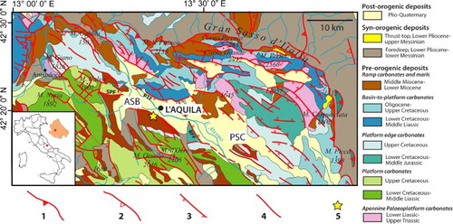
The L’Aquila-Scoppito Basin (ASB) corresponds to the western part of the wider L’Aquila intermontane basin, located in the axial zone of the Apennine chain, between the Gran Sasso Range to the N and the Ocre Mts. to the S, in the central part of the Aterno River Valley. The L’Aquila Basin is bordered by active normal faults showing a significant historical and current seismicity (CitationPace, Peruzza, Lavecchia, & Boncio, 2006), as evidenced by the 6th April 2009 Mw: 6.29 L’Aquila earthquake (CitationAmoroso et al., 2016; CitationFalcucci et al., 2011, Citation2015; CitationGalli, Giaccio, Messina, Peronace, & Zuppi, 2011; CitationGiaccio et al., 2012). The ASB extends from the San Vittorino threshold, to the N, up to the Bazzano-Monticchio Fault, to the S. It is a half-graben delimited to the north by both the south dipping Scoppito-Preturo and the southwest dipping Pettino active faults. The ASB is filled by a thick succession of Plio-Quaternary continental deposits, which unconformably overlay Meso-Cenozoic carbonate units and Upper Miocene terrigenous units () (CitationCosentino, Cipollari, Marsili, & Scrocca, 2010).
Figure 1. Geological sketch-map of ASB and surrounding regions. (1) major thrust; (2) minor thrust; (3) normal fault; (4) undifferentiated fault; (5) epicentre of the 6th April 2009, Mw 6.29 earthquake. ASB: L’Aquila-Scoppito Basin; PSC: Paganica-San Demetrio-Castelnuovo Basin; PTF: Pettino Fault; SPF: Scoppito-Preturo Fault; BFF: Bazzano-Fossa Fault. Modified from CitationCosentino et al. (2017).
In this context, the post-orogenic geological evolution can be key to understanding the present active tectonic regime. The onset of the extensional tectonics, the subsurface bedrock geometries, and the stratigraphy of the continental deposits were studied to reveal the post-orogenic evolution of the ASB.
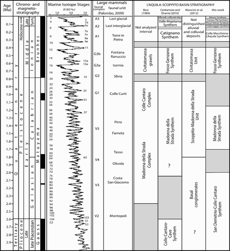
Our study allowed definition of nine synthems characterizing the Plio-Quaternary evolution of the ASB, partly matching stratigraphic units or synthems already described in previous studies (). This new stratigraphy was synthesized in the geological map (1.25,000 scale) provided in this paper, covering an area of about 250 km2. The map is focused on the Plio-Quaternary fill of the ASB, with special emphasis on the spatial distribution and geometry of facies associations, and on its tectonic framework.
Figure 2. Plio-Quaternary stratigraphy of the ASB according to different authors (modified from CitationCosentino et al., 2017). Question mark indicates a possible extension to the Gelasian of the Madonna della Strada Synthem (CitationCentamore & Dramis, 2010) and to the Piacenzian of the Basal Conglomerates (CitationMancini et al., 2012). The PPS is not reported between the Campo di Pile and the Aterno synthems to avoid overlapping.
2. Methods
To reconstruct the Plio-Quaternary geological evolution of the ASB we have adopted a multidisciplinary approach that involved: (1) structural and geomorphological field surveys, which were supported by a fine-scale 1 m LiDAR digital terrain model (DTM; released by Friuli Venezia Giulia Civil Protection Institution); (2) stratigraphic and facies analysis of continental deposits by integrating surface outcrop studies, subsurface data from boreholes, and geophysical investigations (CitationCosentino et al., 2017; CitationImprota et al., 2012; CitationTallini et al., 2012); (3) geochronological dating (14C); and (4) micropaleontological analyses (freshwater molluscs and ostracods).
Field mapping was carried out at 1:5000 scale. However the final map was compiled at 1:25,000 scale using the Carta Tecnica Regionale topographic maps of the Abruzzo Region. The stratigraphic analysis of the Plio-Quaternary basin infill has been mainly carried out through the combined use of the Unconformity-Bounded Stratigraphic Unit (UBSU) method and lithostratigraphic criteria, with unconformity-bounded packages as the fundamental units and lithostratigraphic units included to complement the UBSU framework (CitationRäsänen, Auri, Huitti, Klap, & Virtasalo, 2009; CitationWheeler, 1975). We integrated the newly collected data with literature, making a review of the old continental units described by the Authors (CitationBosi, Messina, & Moro, 2004; CitationCentamore & Dramis, 2010; CitationGruppo di Lavoro MS-AQ, 2010; CitationPucci et al., 2015; CitationSanto et al., 2014) (). The description of the synthems in the main legend of the attached map concerns their lithological, sedimentological, and geomorphological characteristics.
With regard to the Meso-Cenozoic bedrock, we refer to the formal lithostratigraphic Units of the L’Aquila (Sheet 359) (CitationAPAT, 2005) and Pescorocchiano (Sheet 358) (CitationAPAT, 2008) maps of the Geological Map of Italy, Scale 1:50,000 (CitationCentamore & Dramis, 2010; CitationCentamore, Crescenti, & Dramis, 2006).
To define the lithology, thickness and geometry of the basin infill, a comprehensive review of the available well logs was carried out. The dataset comprises more than 900 boreholes drilled before and after the 2009 L’Aquila earthquake for private use, mining exploration and water exploitation, including some deep boreholes drilled for research purposes (CitationAmoroso et al., 2010; CitationDel Monaco, Tallini, De Rose, & & Durante, 2013; CitationGE.MI.NA., 1963; CitationMacrì et al., 2016; CitationPorreca et al., 2016).
The Pre- or Quaternary activity of faults was established based on the age of the youngest deposit displaced by the faults and/or by the existence of morphological evidence of Quaternary tectonic activity.
The buried bedrock morphology of the ASB was reconstructed coupling microtremor recordings with borehole data through the following empirical relation (CitationGosar & Lenart, 2010):where f0 (Hz) is the resonance frequency of the Plio-Quaternary soft cover having a thickness of H (m) and lying onto the stiff Meso-Cenozoic bedrock; 118 and −1.16 are constants obtained from the best fit between bedrock depth from borehole and the f0 measured nearby it ().
Figure 3. f0 (microtremor frequency) vs H (bedrock depth) relationship obtained from boreholes reaching bedrock and microtremor data.
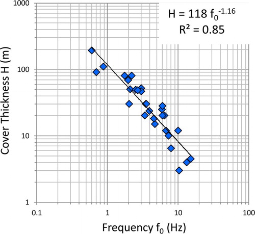
By using this equation, the thickness (H) of the Plio-Quaternary sediments was estimated for about 850 microtremor recordings. The isobaths map was produced, based on a geographical information system (GIS)-aided interpolation, coupling the obtained values with borehole data and considering the outcropping boundary between bedrock and continental deposits as a zero.
3. Stratigraphy of the ASB
The ASB hosts a thick continental succession unconformably deposited above the Meso-Cenozoic bedrock and internally distinguished by several unconformities. We provide a description of these synthems, focusing on their palaeo-environmental meaning, lateral heteropic relationships, and correlations between different sectors of the basin.
3.1. San Demetrio-Colle Cantaro Synthem
The San Demetrio-Colle Cantaro Synthem represents the first depositional phase within the ASB, where it is composed of the Colle Cantaro-Cave Fm (CCF). (Colle Cantaro-Cave Synthem in CitationCentamore & Dramis, 2010). This synthem is also well preserved in the Paganica-San Demetrio-Castelnuovo Basin (PSC) (CitationAmoroso et al., 2016; CitationBosi, 1989), where it is subdivided by a minor unconformity into two Sub-synthems: the Castelnuovo Sub-synthem, composed of different formations (Valle Orsa, Valle Valiano, San Nicandro, Madonna della Neve Fms.) and the Valle dell’Inferno Sub-synthem, this latter not exposed in the study area. This synthem matches the oldest units reported by CitationBoncio et al. (2011) and CitationPucci et al. (2015) in the PSC from which it differs for the age attribution and some stratigraphic interpretation (CitationSpadi, Gliozzi, Cosentino, & Nocentini, 2016).
3.1.1. Colle Cantaro-Cave formation
The CCF crops out rarely at the base of the north-western slopes of the basin, but it is revealed by well logs and a seismic-reflection profile at the base of the basin-filling succession above an unconformity carved into the Meso-Cenozoic bedrock.
The isolated remnants of the CCF are composed of highly heterometric, angular to sub-angular, slope-derived breccias and debris flow deposits, with limestone, marl and sandstone clasts in abundant clayey-silty matrix. Proximal alluvial fan deposits were preserved at Colle Cantaro, consisting of clast-supported, sub-rounded, coarse- to medium-grained, massive conglomerate beds, alternating with sandy and silty layers. Deposits are often back-tilted with respect to the present morphology, testifying to an old landscape no longer preserved.
The CCF is highly deformed as indicated by the occurrence of many outcrop-scale faults and the tilting of the bedding (>20°) as well as by the rapid changes of thickness and its complex geometries.
The CCF is included into the San Demetrio-Colle Cantaro Synthem (late Piacenzian-Gelasian), considering its normal polarity (CitationMessina, Moro, & Speranza, 2001), the similarities between the CCF and the Valle Valiano Fm. (CitationBertini & Bosi, 1993) in the PSC, its stratigraphic position, and the well constrained Calabrian age of the overlying Madonna della Strada Synthem.
3.2. Madonna della Strada Synthem
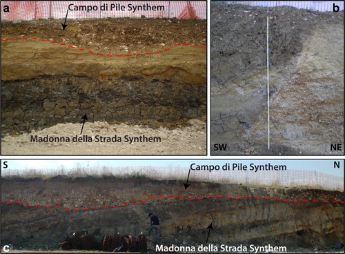
The Madonna della Strada Synthem unconformably overlays the San Demetrio-Colle Cantaro Synthem to the west, while to the east of L’Aquila it lies on a deep erosive surface carved into the bedrock. This synthem is extensively dissected by several normal faults, mainly NW–SE trending, both NE and SW dipping, responsible for the tilting of the deposits, usually about 15°, towards the basin margins ().
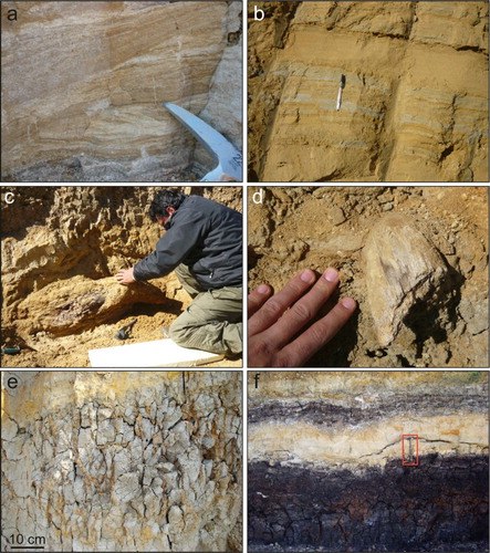
Figure 4. Characteristics of the MDS at Campo di Pile. (a) dark grey massive organic clays and sandy bedform of MDS unconformably covered by the Campo di Pile Synthem; (b): NNW–SSE trending normal fault, that juxtaposed gravels (footwall, right) and clayey silts (hangingwall, left) of MDS; (c) stratigraphic section showing the tilting of MDS towards the southern margin of the basin and the unconformity with the fluvial deposits of the Campo di Pile Synthem (CPF).
The Madonna della Strada Synthem is composed of two heteropic formations: the Madonna della Strada Fm. (MDS) and the San Marco Fm. (SMF).
The MDS is composed, from the bottom, of yellowish sandy silt and sand beds, rarely showing planar cross-stratification, densely interlayered with thin clayey levels, which become more abundant and thick upward, passing to dark grey massive organic clays and clayey silts, containing several lignite seam intercalations (CitationBosi, Galadini, Giaccio, Messina, & Sposato, 2003; CitationCentamore & Dramis, 2010; CitationCentamore et al., 2006; CitationStorti et al., 2013). In the lower and middle part of the synthem, coarse- to medium-grained, well-rounded sandy gravel beds are present, showing channelized geometries, variable thickness, planar and through cross-bedding. Lignite and gravel intercalations disappear in the upper portion of MDS replaced by yellow-reddish sand and silty sand beds, characterized by fining upward sequences with oxidized surfaces, planar cross-stratification and ripple marks. Pedogenized horizons, calcrete, mottles, and root traces are widespread, testifying the existence of temporary emerged areas ().
Figure 5. Sedimentary characteristics and mammal remains of the MDS. (a) Grey clays overlaid by laminated coarse sands, with angular clasts, grading into planar cross-stratified sand (Campo di Pile industrial area); (b) alternation of coarse sands and silty-clayey layers cut by cm-scale syn-sedimentary fault planes (Via della Polveriera, south L’Aquila Hill); (c) tusk of M. meridionalis found at Campo di Pile industrial area; (d) horn of not identified bovid found at Campo di Pile industrial area; (e) root casts (rizholiths) with oxidized organic matter fill (Pagliare di Sassa); (f) lignite seam with interlayered sand horizon (Colle Mancino, Genzano) (hammer for scale into the red rectangle).
Micropaleontological analyses reveal an ostracod assemblage completely different with respect to that occurring within the San Demetrio-Colle Cantaro Synthem (CitationSpadi et al., 2016), and consisting of: Candona (Neglecandona) neglecta, Pseudocandona marchica, Ilyocypris bradyi, Eucypris dulcifrons, Eucypris pigra, Potamocypris zschokkei, and Paralimnocythere messanai (CitationCosentino et al., 2017). Gastropod assemblage is rich in Planorbis planorbis, with the contemporary presence of the pulmonate Gyraulus albus and the prosobranch Bithynia leachii and several specimens of Stagnicola sp. These assemblages testify to wetland with temporary swamps characterized by permanent shallow water bodies with slowly flowing water (CitationWelther-Schultes, 2012).
The described lithofacies, coupled with the paleoenvironmental data derived from paleontological analyses, indicate the MDS to be a meandering fluvial system with a wide floodplain and swampy areas.
Along the main boundary faults, the MDS heteropically passes into well-cemented, massive to well-stratified, clast-supported, heterometric calcareous breccias with abundant pinkish calcareous matrix of the SMF. Generally, these deposits are less than 25 m and correspond to the San Marco Breccias in CitationMessina, Bosi, and Moro (2003), characterized by reverse magnetic polarity and referred to the Lower Pleistocene (CitationMessina et al., 2001).
The age of the Madonna della Strada Synthem is well constrained by the occurrence of some large mammal remains recovered at Campo di Pile comprising: Equus suessenbornensis, Axis eurygonos, Praemegaceros obscurus. These mammal remains, with the addition of M. meridionalis () (CitationAgostini, Palombo, Rossi, Di Canzio, & Tallini, 2012), corresponds to the Pirro Nord FU, although a younger age (still older than Colle Curti FU) cannot be ruled out (CitationCosentino et al., 2017; CitationMagri, Di Rita, & Palombo, 2010).
In summary up, the absence of the ostracod assemblages typical of the San Demetrio-Colle Cantaro Synthem, the reverse magnetic polarity of its deposits (CitationMessina et al., 2001) and the presence of a mammal assemblage belonging to the Pirro Nord FU, constrain the MDS to the lower and middle part of the Calabrian or, in any case, to an Early Pleistocene age older than 1.2 Ma (CitationCosentino et al., 2017).
3.3. Fosso di Genzano Synthem
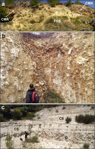
The Fosso di Genzano Synthem (FGS) lies above an erosional surface carved into both MDS and the Meso-Cenozoic bedrock. Its upper boundary, when preserved, is represented by a quite well developed sub-horizontal surface, usually lying more than 40 m above the present floodplain.
The outcropping deposits are formed by coarse- to medium-grained, sub-rounded, clast-supported, sheet-type gravel beds, with massive or horizontal bedding, capped by thin lenses of laminated to massive silty sands (CitationCentamore & Dramis, 2010; CitationCentamore et al., 2006; CitationMancini et al., 2012). These deposits grade upward into well-sorted, well-rounded gravel beds with coarse sandy matrix, showing cut and fill structures, interlayered with yellowish sandy bedform, planar and through cross-stratified. Coarse-grained deposits heteropically pass into well-stratified, fining upward overbank sediments, formed by yellowish-greyish coarse- to fine-grained sand beds with ripples, planar and through cross-stratifications, alternating with laminated grey clayey silt ((a)).
Figure 7. (a) Scoop-shaped basal unconformity of the Colle Macchione-L’Aquila Synthem (CMA) above the deformed deposits of the FGS at Colle Macchione; (b) poorly sorted, clast-supported massive calcareous breccia of CMA (Collemaggio, L’Aquila); (c) calcareous clayey silt level (CS) interlayered within calcareous gravels (G) (upper portion of CMA) (Via Cisternole, L’Aquila).
These gravelly lithofacies belong to a braided, sometimes wandering, fluvial system associated with lateral alluvial fans, as indicated by paleocurrent analyses showing eastward and northward flow directions. Several K-alkaline tephra layers are reported within this synthem, helping to constrain its age and to correlate its deposits across the basin (CitationCentamore & Dramis, 2010; CitationGalli, Giaccio, & Messina, 2010).
By taking into account the chronological constraints from mammal remains, the normal polarity of the Pagliare di Sassa succession (CitationPalombo et al., 2010), the 39Ar/40Ar dating of the ash layers from Sella di Corno (520 ± 5 ka) (CitationCentamore & Dramis, 2010) and the ages suggested for tephra layers by CitationGalli et al. (2010), FGS can be referred to the lower Middle Pleistocene (CitationCosentino et al., 2017).
3.4. Colle Macchione-L’Aquila Synthem
In the central part of the ASB, the Colle Macchione-L’Aquila Synthem (CMA) unconformably overlies either the older Plio-Quaternary synthems or the Mesozoic and Tertiary bedrock.
The base of CMA is highly irregular and erosive, characterized by scoop surfaces deeply entrenched into the older sediments (FGS, MDS). FGS and MDS are eroded and deformed by the arrival of the breccias, as indicated by the folding of the bedding and the presence of clasts ripped up by the underlying deposits. These conditions are clearly visible at Colle Macchione, where the CMA unconformably overlies deformed sands and sandy silts pertaining to the FGS.
The CMA consists of breccias and megabreccias, with highly heterometric, poorly sorted, angular to sub-angular carbonate blocks in a whitish-yellowish calcareous sandy silty matrix. The breccias can be clast- to matrix-supported, usually massive but sometimes also stratified, both well-cemented and incoherent (CitationCentamore & Dramis, 2010; CitationCentamore et al., 2006; CitationDemangeot, 1965) (). Clast lithologies are mainly from the slope-to-basin successions outcropping at the northern boundary of the ASB. The characteristics of the CMA point to debris flow and rock avalanche processes derived from the slopes of the mountain chains surrounding the basin during cold or glacial climatic stages (CitationCosentino et al., 2017; CitationEsposito, Scarascia Mugnozza, Tallini, & Della Seta, 2014).
In L’Aquila, whitish to greyish calcareous clayey silt levels (CMAa in the map) are interlayered within the breccias, separating different debris flow events and testifying to the presence of standing water within the basin (). Carbonate silts contain a monospecific ostracod fauna consisting of Mixtacandona stammeri, which is an hyporheic species typical of interstitial waters (CitationCosentino et al., 2017).
These breccias are generally referred to the Middle Pleistocene (CitationBosi et al., 2003; CitationDemangeot, 1965). A late Middle Pleistocene age is supported by the stratigraphy of the Colle Macchione ridge, where the CMA overlies the lower Middle Pleistocene FGS, and by the presence on top of the CMA, in the area of the S. Salvatore Hospital and of the law court buildings, of the lower Late Pleistocene Fosso Vetoio Synthem (FVS), thus, suggesting a late Middle Pleistocene age.
3.5. Collemaggio Synthem
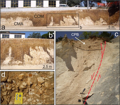
In the L’Aquila hill area, reddish to dark brown clayey silt deposits (Terre rosse Auct.) with sparse sub-angular clasts, mainly limestones and cherts, are present above the CMA, as karst fill deposits or as colluvium, forming the Collemaggio Synthem (COM). This synthem caps the epikarst developed on the top of the CMA with a highly variable thickness, from several meters up to 20 m ((a,b)).
Figure 8. (a) Epikarst on calcareous breccia (Colle Macchione-L’Aquila Synthem, CMA) capped by colluviated reddish soil (Collemaggio Synthem, COM); (b): close view of the epikarst; (c) heterometric, matrix-supported slope deposits of the Campo di Pile Synthem (CPB) in the hangingwall of the Scoppito-Preturo Fault; (d) alluvial deposits, mainly carbonate gravels, of the Campo di Pile Synthem (CPF), ch: cherty gravel (cherty flakes, Mousterian industry); bx: gravel of Cenomanian bauxite coming from the Campo Felice area.
These sediments are generally interpreted as a reworked paleosol (Alfisol) formed onto the CMA calcareous breccias in wet and warm interglacial conditions (CitationMagaldi & Tallini, 2000). Thus considering the late Middle Pleistocene age of the CMA and paleopedological considerations (CitationMagaldi & Tallini, 2000), the COM can be related to the Eemian interglacial stage (MIS 5e) (i.e. lower part of Late Pleistocene) (CitationLisiecki & Raymo, 2005).
3.6. Fosso Vetoio Synthem
The base of the FVS is carved into both the CMA and MDS and, locally, continues laterally onto the bedrock. The FVS forms the first order of Late Pleistocene fluvial terraces (T1), showing an abandonment surface lying approximately 20–25 m above the Aterno thalweg.
The FVS consists of fine-to medium-grained, well-sorted, well-rounded, sub-flattened, clast-supported gravel beds, with well-preserved sheet-type channels characterized by trough cross- and horizontal bedding (CitationBlumetti, Cavinato, & Tallini, 1996; CitationCentamore & Dramis, 2010; CitationCentamore et al., 2006; CitationMessina et al., 2003). Gravel beds contain an abundant coarse sandy matrix and, locally, massive silty sandy lenses are present, representing abandoned channel filling deposits of a braided fluvial system. Pebbles are mainly carbonates showing imbrication towards E/SE. Gravels grade upward into an alternating succession of rust colour planar cross-stratified sands and yellow laminated silts, covered by greyish massive coarse sands, interpreted as overbank deposits.
Considering the late Middle Pleistocene age of the underlying CMA and the morpho-stratigraphical relationships with the younger Campo di Pile Synthem, which is well constrained by 14C dating, an early Late Pleistocene age (MIS 5a) is suggested for the FVS as reported in CitationNocentini (2016), CitationNocentini, Tallini, Asti, and Cosentino (2014) and CitationCosentino et al. (2017).
3.7. Campo di Pile Synthem
The Campo di Pile Synthem comprises fluvial and alluvial fan (CPF) sediments, as well as slope-derived deposits (CPB) usually embedded in FVS and carved into both the older continental deposits and the pre-Pliocene bedrock.
Slope-derived sediments (CPB) outcrop at the margins of the ASB, both at the base of the slopes and suspended at higher elevations, and usually deposited on the hangingwall of the main active faults ((c)). They are composed of fine- to medium-grained, poorly cemented, well-stratified carbonate breccias, both matrix- and clast-supported, occasionally open-work. The silty sandy matrix has a pale brownish to pinkish colour and contains both clayey and volcanic minerals. Dark brown-reddish pedogenic horizons are interlayered at different elevations (CitationColtorti & Pieruccini, 2006), marking the presence of minor erosive surfaces.
Alluvial fan systems, composed of fine- to coarse-grained, sub-angular to sub-rounded, well-sorted, clinostratified calcareous gravel beds, are not well preserved in the ASB. Remnants of these deposits cap the slopes between Pianola and Bagno, where they are incised and suspended above the present-day base level.
Fluvial deposits (CPF), usually less than 5 m thick and characterized by sheet-type geometry with a flat basal unconformity, are mainly preserved in the southern and western sectors of the ASB ((a)). They are composed of fine- to coarse-grained, poorly sorted, sub- to well-rounded, clast-supported gravel beds, showing horizontal and, subordinately, trough cross-bedding, with abundant silty sandy matrix. Clasts consist mainly of limestones and, more rarely, bauxites ((d)). Gravels are interlayered with or laterally pass to coarse- to medium-grained sand, with well-preserved planar and trough cross-stratifications, interpreted as levee and bar deposits. Massive and laminated silts and clayey silts, showing plant roots and oxidized surfaces, are locally preserved above gravel beds, representing abandoned channel fill. These lithofacies belong to an eastward draining wandering-braided river system that formed the second order fluvial terrace (T2), interpreted as a strath, whose top lies 10–13 m above the present thalweg.
To constrain the age of the Campo di Pile Synthem, 14C dating was performed on charcoaled plant remains collected from fluvial coarse sands, giving a 2σ age of 40,464–41,845 yr cal BP.
This age is in agreement with the founding (within the gravels of CPF) of lithic and bone artefacts of Mousterian industry (late Middle Paleolithic), allowing it to be referred to the upper part of the Late Pleistocene and to correlate it with MIS 3.
3.8. Ponte Peschio Synthem
The Ponte Peschio Synthem (PPS) comprises small remnants of an erosive flat surface between T2 and the active floodplain. PPS is well preserved only in the central part of the ASB. This surface defines the T3 fluvial terrace, characterized by absent or very thin alluvial deposits, lying at 5–7 m above the present thalweg. Near the S. Salvatore Hospital, T3 is embedded in the FVS (T1) and carved into the CMA, while at Ponte Peschio, it is embedded into the CPF (T2) and carved directly into the pre-Pliocene bedrock. PPS may be interpreted as a strath terrace, related to a minor erosional phase that occurred after the formation of the CPF (T2) fluvial terrace, probably linked to tectonic uplift in the ASB coupled with the Last Glacial Maximum climate changes. Thus, the PPS can be related to MIS 2, that is the final part of the Late Pleistocene (<29 ka).
3.9. Aterno Synthem
Holocene fluvial deposits (ATF) are the most represented in the ASB. They consist of medium- to fine-grained, well-sorted, sub- to well-rounded, loose sandy gravel beds, alternating with levee medium sand and silty sands layers, passing to overbank clayey silts.
Well-sorted, well-rounded, and well-stratified coarse-grained gravel of alluvial fan environment are present at the outlet of the main valleys or along the slopes at the basin margins, sometimes entrenched into older alluvial fans.
Holocene talus cone and scree deposits (TLS) cap the lower part of steep slopes, locally covering the older wider and thicker slope-derived deposits of the CPB. They are generally less than 10 m thick and made of loose heterometric, angular calcareous pebbles and boulders, with a greyish sandy silty matrix.
Holocene colluvium (COL) consists of massive to poorly stratified brownish-reddish sandy silts and silty clay, with abundant angular to sub-angular, poorly sorted limestones and cherts with sparse pottery. The thickness is generally less than 15 m. These deposits are often displaced and form the colluvial wedges of the main active faults.
The Aterno Synthem also comprises heterometric and heterogeneous anthropic deposits (not mapped), as well as the landslides reported on the geological map.
4. Subsurface data
4.1. Pettino1 seismic-reflection profile
Five different seismic facies were distinguished from the Pettino1 seismic-reflection profile reported on the attached map (CitationCosentino et al., 2017).
Seismic facies S is represented by a chaotic signal with low-amplitude, discontinuous reflectors. It is interpreted as the acoustic pre-Pliocene ASB bedrock.
Seismic facies R is characterized by high amplitude and fairly continuous reflectors, consistent with the clastic deposits of the CCF. The wedge geometries of this seismic facies, together with the structural setting of the ASB, point to syn-rift deposition into a tectonically controlled basin.
Seismic facies L is composed of continuous and parallel reflectors, with medium to high amplitude. Some boreholes drilled in the northern part of the ASB (CitationAmoroso et al., 2010; CitationGE.MI.NA., 1963), allowed us to correlate the seismic facies L to the MDS, whose deposition might have occurred during a post-rift stage.
Seismic facies BC is defined by continuous, low-amplitude reflectors, with parallel to irregular and chaotic geometries. Both the stratigraphic position and the internal geometries of this seismic facies allow us to refer it to the CMA.
Seismic facies AD is generally characterized by a chaotic signal, with seismic reflectors of medium-low-amplitude. It is possible to refer it to the younger deposits of the ASB fill (FVS, CPF, ATF).
4.2. The isobaths map of the Meso-Cenozoic bedrock
This Main Map is useful for identifying the buried morphology of the ASB, to draw the base of the continental deposits in the geological cross-section, and to define the thickness of the Plio-Quaternary sediments.
The bedrock shows an irregular paleomorphology, with paleovalleys, morpho-structural highs, sharp bedrock-infilling contacts, and steep buried escarpments, that can be related to inherited morphologies or to the presence of faults.
Two deep depocenters, NW–SE trending, are highlighted below the L’Aquila hill and the S. Salvatore Hospital, with a maximum depth of 340 and 210 m, respectively. These depocenters, separated by a NNE–SSW ridge, are characterized by a steep northern boundary probably related to the presence of synthetic splays of the Pettino Fault.
Between Coppito village and the Pettino Fault, a structural high, with bedrock depth between 20 and 40 m, separates the eastern and western sector of the ASB, with the latter characterized by a N–S elongated paleovalley, generally less than 100 m deep.
4.3. Well logs analysis
The well logs panel is reported in the attached map. Well logs show rapid changes of the thickness and facies of the Quaternary deposits, as well as of the bedrock depth, which reflect the intense deformation that occurred during and after the onset of the ASB.
The CCF was drilled at the base of the basin infill in almost all of the wells, except for those drilled between the L’Aquila Hill and the Bazzano-Monticchio ridge (S45, S46; S80, S57, S59, S80, S112) or S31 drilled near the Collettara ridge. The CCF shows a maximum thickness of about 70 m close to the basin margins (S28, S1).
Well logs highlight the presence of the MDS in all the boreholes drilled in the ASB, lying above irregular surfaces carved both in the Meso-Cenozoic bedrock and in CCF. The thickness of the MDS is about 70 m in the western ASB (S28) and decreases to 10–20 m towards the central part (S20, S43), to increase again eastward, where S80 drilled 215 m of fine-grained deposits referable to the MDS ().
Figure 6. Details of the deep borehole deposits. (a) lignite level within the clayey silts of the Madonna della Strada Synthem (S80: −136.9 m); (b) pedogenized horizon and Fe–Mn level at the boundary between Madonna della Strada Synthem and FGS (S46: −16.7 m); (c) fluid expulsion sedimentary structure (paleo-seismite) within Madonna della Strada Synthem (S45: −76.7 ÷ −76.9 m); (d) stratigraphic boundaries between Colle Macchione – L’Aquila Synthem, FGS and Madonna della Strada Synthem from borehole S112.
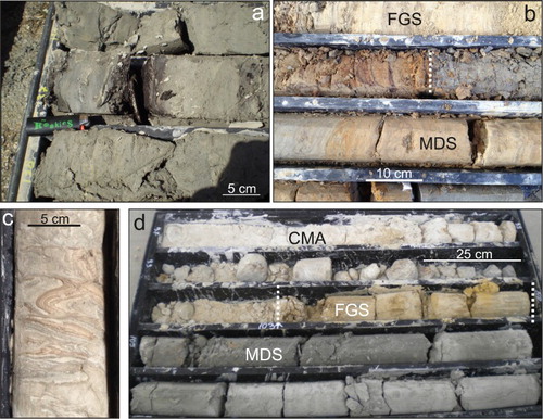
The FGS is not reported in the western sector of the ASB (S28, S1, S23), while in the other parts of the basin it was found discontinuously and with reduced thicknesses. Close to L’Aquila Hill and surrounding areas, the FGS is overlaid by the coarse-grained deposits of the CMA (S17, S18, S45, S80, S112), confirming their stratigraphic position.
The stratigraphic relationships among the Middle-Late Pleistocene synthems of the ASB are illustrated by well S17, drilled close to the S. Salvatore Hospital.
5. Conclusions
Our results allowed us to define nine synthems pertaining to the ASB. This new stratigraphy was synthesized in the presented fine-scale geological map in which we emphasize the Plio-Quaternary synthems and tectonic setting.
The Plio-Quaternary geological evolution of the ASB is as follows.
The syn-rift stage: late Piacenzian-Gelasian age. Slope-derived breccias, debris flow deposits and proximal alluvial fan deposits represent the first stage of basin filling (San Demetrio-Colle Cantaro Synthem). The seismic-reflection profile shows wedge-shaped seismic facies and progressive angular unconformities characterizing the ASB older basin fill (CCF). A strong regional tectonic uplift is recorded at the Gelasian/Calabrian transition (CitationCosentino et al., 2017).
The post-rift stages:
Calabrian age. Meandering fluvial system with floodplains and extended swampy areas developed (Madonna della Strada Synthem).
Early Middle Pleistocene age. Alluvial fan deposits, laterally passing to braided alluvial plains developed (FGS).
Late Middle Pleistocene age. Debris flows and rock avalanches, originating from the northern margin of the ASB, were deposited into the basin (Colle Macchione – L’Aquila Synthem – CMA).
Late Pleistocene age. The ASB was characterized by the development of three orders of fluvial terraces (T1, T2, and T3) represented by the Fosso Vetoio, Campo di Pile, and PPSs, respectively. T2 belongs to the Campo di Pile Synthem and correlates with MIS 3, since it shows a 14C age of 41,854-40,464 yr cal BP.
Holocene age. Fluvial and alluvial fan deposits of the Aterno River and its main tributaries (Aterno Synthem).
Software
Field data, boreholes, and geophysical surveys were organized in an Esri ArcGIS10.1® database, containing previous map, orthophotos, and DEM. LiDAR data were processed with Esri ArcGIS10.1® to obtain the high-resolution DTM. The geological map was elaborated using Esri ArcGIS10.1®, while geological cross-sections, drawings, layout, and final editing were realized with Adobe Illustrator®.
Plio-Quaternary geology of L'Aquila – Scoppito Basin (Central Italy).pdf
Download PDF (84.5 MB)Acknowledgements
Thanks to Giuseppe Di Giulio and Giuliano Milana for the stimulating discussion on microtremor technique and to the reviewers Jennifer E. Carrell, Claudio Nicola Di Celma and Tommaso Piacentini for their suggestions which improved the manuscript and the map. Digital cartography by courtesy of Abruzzo Region. The airborne LiDAR survey, carried out by Friuli Venezia Giulia Civil Protection Institution, was made available by courtesy of Italian Civil Protection Department.
Disclosure statement
No potential conflict of interest was reported by the authors.
ORCID
Marco Nocentini http://orcid.org/0000-0001-8772-7496
Domenico Cosentino http://orcid.org/0000-0002-7470-476X
Federica Durante http://orcid.org/0000-0003-1442-3808
Elsa Gliozzi http://orcid.org/0000-0001-5608-1995
Marco Tallini http://orcid.org/0000-0003-4641-7824
Related Research Data
References
- Agostini, S., Palombo, M. R., Rossi, M. A., Di Canzio, E., & Tallini, M. (2012). Mammuthus meridionalis (Nesti, 1825) from Campo di Pile (L’Aquila, Abruzzo, Central Italy). Quaternary International, 276–277, 42–52. doi: 10.1016/j.quaint.2012.05.013
- Amoroso, S., Bernardini, F., Blumetti, A. M., Civico, R., Doglioni, C., Galadini, F., … Vittori, E. (2016). Quaternary geology and paleoseismology in the Fucino and L’Aquila basins. Geological field trips. Periodico semestrale del Servizio Geologico d'Italia – ISPRA e della Società Geologica Italiana, 8(1.2), 88 pp., 79 figs, 1 tab. doi: 10.3301/GFT.2016.02
- Amoroso, S., Del Monaco, F., Di Eusebio, F., Monaco, P., Taddei, B., Tallini, M., … Totani, G. (2010). Campagna di indagini geologiche, geotecniche e geofisiche per lo studio della risposta sismica locale della città dell’Aquila: la stratigrafia dei sondaggi (giugno – agosto 2010) (Report CERFIS n. 1, 2010).
- APAT. (2005). Sheet 359 “L’Aquila”. Geological Map of Italy, Scale 1:50000. APAT – Dipartimento Difesa del Suolo.
- APAT. (2008). Sheet 358 “Pescorocchiano”. Geological Map of Italy, Scale 1:50000. APAT – Servizio Geologico d’Italia – Dipartimento Difesa del Suolo.
- Bertini, T., & Bosi, C. (1993). La tettonica quaternaria della conca di Fossa (L’Aquila). Il Quaternario (Italian Journal of Quaternary Sciences), 6, 293–314.
- Blumetti, A. M., Cavinato, G. P., & Tallini, M. (1996). Evoluzione Plio-Quaternaria della Conca di L'Aquila-Scoppito: Studio preliminare. Il Quaternario (Italian Journal of Quaternary Sciences), 9, 281–286.
- Boncio, P., Pizzi, A., Cavuoto, G., Mancini, M., Piacentini, T., Miccadei, E., … Working Group Macroarea3. (2011). Geological and geophysical characterisation of the Paganica-San Gregorio area after the April 6, 2009 L’Aquila earthquake (Mw 6.3, central Italy): Implications for site response. Bollettino di Geofisica Teorica ed Applicata, 52(3), 491–512.
- Bosi, C. (1989). Tentativo di correlazione fra le successioni plio-pleistoceniche. In: C.N.R., Centro di Studio per la Geologia Tecnica & ENEA, P.A.S.: “Elementi di tettonica pliocenico-quaternaria ed indizi di sismicità olocenica nell'Appennino laziale-abruzzese,” Soc. Geol. It., Rome, pp. 97–104.
- Bosi, C., Galadini, F., Giaccio, B., Messina, P., & Sposato, A. (2003). Plio-Quaternary continental deposits in the Latium-Abruzzi Apennines: The correlation of geological events across different intermontane basins. Il Quaternario (Italian Journal of Quaternary Sciences), 16(1bis), 55–76.
- Bosi, C., Messina, P., & Moro, M. (2004). Use of the allo-morphosequential units in the Quaternary geological map of the upper Aterno valley (central Italy). Quaternary geological map of the upper Aterno valley (Central Italy). In G. Pasquarè, & C. Venturini (Eds.), Mapping geology in Italy (pp. 107–112). Firenze: APAT, Dip. Dif. del Suolo. Selca.
- Centamore, E., Crescenti, U., & Dramis, F. (2006). Note illustrative della Carta Geologica d’Italia alla scala 1:50.000, Foglio 359-L’Aquila. APAT-Dipartimento Difesa del Suolo-Servizio Geologico d’Italia, Ente realizzatore Regione Abruzzo, pp. 128. Retrieved from http://www.isprambiente.gov.it/Media/carg/note_illustrative/359_LAquila.pdf
- Centamore, E., & Dramis, F. (2010). Note illustrative della Carta Geologica d’Italia alla scala 1:50.000, Foglio 358-Pescorocchiano. ISPRA-Servizio Geologico d’Italia, Ente realizzatore Regione Lazio, pp. 147. Retrieved from http://www.isprambiente.gov.it/Media/carg/note_illustrative/358_Pescorocchiano.pdf
- Coltorti, M., & Pieruccini, P. (2006). The last interglacial pedocomplexes in the litho- and morpho-stratigraphical framework of the central-northern Apennines (Central Italy). Quaternary International, 156–157, 118–132. doi: 10.1016/j.quaint.2006.05.025
- Cosentino, D., Asti, R., Nocentini, M., Gliozzi, E., Kotsakis, T., Mattei, M., … Di Fiore, V. (2017). New insights into the onset and subsequent evolution of the central Apennine extensional intermontane basins from the tectonically active L’Aquila Basin (central Italy). Geological Society of America Bulletin, 129, doi.org/10.1130/B31679.1
- Cosentino, D., Cipollari, P., Marsili, P., & Scrocca, D. (2010). Geology of the central Apennines: a regional review. In: Beltrando, M., Peccerillo, A., Mattei, M., Conticelli, S., Doglioni, C., The Geology of Italy, Journal of the Virtual Explorer, Electronic Edition, ISSN 1441-8142, volume 36, paper 11.
- Del Monaco, F., Tallini, M., De Rose, C., & & Durante, F. (2013). HVNSR survey in historical downtown L'Aquila (central Italy): Site resonance properties vs. subsoil model. Engineering Geology, 158, 34–47. doi: 10.1016/j.enggeo.2013.03.008
- Demangeot, J. (1965). Géomorphologie des Abruzzes adriatiques. These, Lettres, 84 pp. Éditions du CNRS, Paris.
- Esposito, C., Scarascia Mugnozza, G., Tallini, M., & Della Seta, M. (2014). Evidence of Quaternary rock avalanches in the central Apennines: New data and interpretation of the huge clastic deposit of the L'Aquila basin (central Apennines, Italy). EGU General Assembly 2014, Vienna, id.12238, 2014EGUGA. 1612238E.
- Falcucci, E., Gori, S., Moro, M., Fubelli, G., Saroli, M., Chiarabba, C., & Galadini, F. (2015). Deep reaching versus vertically restricted Quaternary normal faults: Implications on seismic potential assessment in tectonically active regions: Lessons from the middle Aterno valley fault system, central Italy. Tectonophysics, 651–652, 186–198. doi: 10.1016/j.tecto.2015.03.021
- Falcucci, E., Gori, S., Moro, M., Pisani, A. M., Melini, D., Galadini, F., & Fredi, P. (2011). The 2009 L'Aquila earthquake (Italy): What's next in the region? Hints from stress diffusion analysis and normal fault activity. Earth and Planetary Science Letters, 305, 350–358. doi: 10.1016/j.epsl.2011.03.016
- Galli, P., Giaccio, B., & Messina, P. (2010). The 2009 central Italy earthquake seen through 0.5 Myr-long tectonic history of the L’Aquila faults system. Quaternary Science Reviews, 29, 3768–3789. doi: 10.1016/j.quascirev.2010.08.018
- Galli, P., Giaccio, B., Messina, P., Peronace, E., & Zuppi, G. M. (2011). Paleoseismology of the L’Aquila faults (central Italy, 2009, Mw 6.3 earthquake): Implications for active fault linkage. Geophysical Journal International, 187, 1119–1134. doi: 10.1111/j.1365-246X.2011.05233.x
- GE.MI.NA. (1963). Ligniti e torbe dell’Italia continentale. Turin: ILTE Ed.
- Giaccio, B., Galli, P., Messina, P., Peronace, E., Scardia, G., Sottili, G., … Silvestri, S. (2012). Fault and basin depocentre migration over the last 2 Ma in the L’Aquila 2009 earthquake region, central Italian Apennines. Quaternary Science Reviews, 56, 69–88. doi: 10.1016/j.quascirev.2012.08.016
- Gosar, A., & Lenart, A. (2010). Mapping the thickness of sediments in the Ljubljana Moor basin (Slovenia) using microtremors. Bulletin of Earthquake Engineering, 8, 501–518. doi: 10.1007/s10518-009-9115-8
- Gruppo di Lavoro MS–AQ (2010). Microzonazione sismica per la ricostruzione dell'area aquilana. Regione Abruzzo – Dipartimento della Protezione Civile, L'Aquila, 3 vol. and Cd-rom.
- Improta, L., Villani, F., Bruno, P. P., Castiello, A., De Rosa, D., Varriale, F., … Giacomuzzi, G. (2012). High-resolution controlled-source seismic tomography across the Middle Aterno basin in the epicentral area of the 2009, Mw 6.3, L’Aquila earthquake (central Apennines, Italy). Italian Journal of Geosciences, 131(3), 373–388.
- Lisiecki, L. E., & Raymo, M. E. (2005). A Pliocene-Pleistocene stack of 57 globally distributed benthic δ18O records. Paleoceanography, 20, PA1003. doi: 10.1029/2004PA001071
- Macrì, P., Smedile, A., Speranza, F., Sagnotti, L., Porreca, M., Mochales, T., & Russo Ermolli, E. (2016). Analysis of a 150 m sediment core from the co-seismic subsidence depocenter of the 2009 Mw = 6.1 L'Aquila earthquake (Italy): Implications for Holocene-Pleistocene tectonic subsidence rates and for the age of the seismogenic Paganica fault system. Tectonophysics. doi: 10.1016/j.tecto.2016.09.004
- Magaldi, D., & Tallini, M. (2000). A micromorphological index of soil development for the Quaternary geology research. Catena, 41, 261–276. doi: 10.1016/S0341-8162(00)00096-5
- Magri, D., Di Rita, F., & Palombo, M. R. (2010). An early Pleistocene interglacial record from an intermontane basin of central Italy (Scoppito, L’Aquila). Quaternary International, 225, 106–113. doi: 10.1016/j.quaint.2009.04.005
- Mancini, M., Cavuoto, G., Pandolfi, L., Petronio, C., Salari, L., & Sardella, R. (2012). Coupling basin infill history and mammal biochronology in a Pleistocene intermontane basin: The case of western L’Aquila Basin (central Apennines, Italy). Quaternary International, 267, 62–77. doi: 10.1016/j.quaint.2011.03.020
- Messina, P., Bosi, C., & Moro, M. (2003). Sedimenti e forme quaternari nell’alta valle dell’Aterno (L’Aquila). Il Quaternario (Italian Journal of Quaternary Sciences), 16(2), 231–239.
- Messina, P., Moro, M., & Speranza, F. (2001). Primi risultati di stratigrafia magnetica su alcune formazioni continentali dell’alta Valle dell’Aterno (Italia centrale). Il Quaternario (Italian Journal of Quaternary Sciences), 14(2), 167–172.
- Nocentini, M. (2016). Integrated analysis for intermontane basins studies: Tectono-stratigraphic and paleoclimatic evolution of the L’Aquila Basin. PhD thesis in Environmental and Resources Geology, University of Roma Tre (XXVII cycle).
- Nocentini, M., Tallini, M., Asti, R., & Cosentino, D. (2014). Late Quaternary river incision rate from L'Aquila-Scoppito Basin (central Apennines, Italy). EGU General Assembly 2014, Vienna, id. 14878, 2014EGUGA. 1614878N.
- Pace, B., Peruzza, L., Lavecchia, G., & Boncio, P. (2006). Layered seismogenic source model and probabilistic seismic hazard analyses in central Italy. Bulletin of the Seismological Society of America, 96, 107–132. doi: 10.1785/0120040231
- Palombo, M. R., Mussi, M., Agostini, S., Barbieri, M., Di Canzio, E., Di Rita, F., … Tagliacozzo, A. (2010). Human peopling of Italian intermontane basins: The early Middle Pleistocene site of Pagliare di Sassa (L’Aquila, central Italy). Quaternary International, 223–224, 170–178. doi: 10.1016/j.quaint.2009.10.038
- Porreca, M., Smedile, A., Speranza, F., Mochales Lopez, T., D'Ajello Caracciolo, F., Di Giulio, G., … Sagnotti, L. (2016). Geological reconstruction in the area of maximum co-seismic subsidence during the 2009 Mw=6.1 L’Aquila earthquake using geophysical and borehole data. Italian Journal of Geosciences, 135, 350–362. doi: 10.3301/IJG.2015.37
- Pucci, S., Villani, F., Civico, R., Pantosti, D., Del Carlo, P., Smedile, A., … Gueli, A. (2015). Quaternary geology of the Middle Aterno Valley, 2009 L'Aquila earthquake area (Abruzzi Apennines, Italy). Journal of Maps, 11, 689–697. doi: 10.1080/17445647.2014.927128
- Räsänen, M.-E., Auri, J. M., Huitti, J. V., Klap, A. K., & Virtasalo, J. J. (2009). A shift from lithostratigraphic to allostratigraphic classification of Quaternary glacial deposits. GSA Today, 19, 4–11. doi: 10.1130/GSATG20A.1
- Santo, S., Ascione, A., Di Crescenzo, G., Miccadei, E., Piacentini, T., & Valente, E. (2014). Tectonic-geomorphological map of the middle Aterno River valley (Abruzzo, Central Italy). Journal of Maps, 10, 365–378. doi: 10.1080/17445647.2013.867545
- Spadi, M., Gliozzi, E., Cosentino, D., & Nocentini, M. (2016). Late Piacenzian-Gelasian freshwater ostracods (Crustacea) from L’Aquila Basin (central Apennines, Italy). Journal of Systematic Palaeontology, 14(7), 617–642. doi: 10.1080/14772019.2015.1079561
- Storti, F., Aldega, L., Balsamo, F., Corrado, S., Del Monaco, F., Di Paolo, L., … Tallini, M. (2013). Evidence for strong middle Pleistocene earthquakes in the epicentral area of the 6 April 2009 L'Aquila seismic event from sediment paleofluidization and overconsolidation. Journal of Geophysical Research: Solid Earth, 118(7), 3767–3784.
- Tallini, M., Cavuoto, G., Del Monaco, F., Di Fiore, V., Mancini, M., Caielli, G., … Rapolla, A. (2012). Seismic surveys integrated with geological data for in-depth investigation of Mt. Pettino active Fault area (Western L’Aquila Basin). Italian Journal of Geoscience, 131, 389–402. doi: 10.3301/IJG.2012.10
- Welther-Schultes, F. (2012). European non-marine molluscs, a guide for species identification. Planet Poster Edition, Göttingen, 3–674.
- Wheeler, H. E. (1975). Note 24- unconformity-bounded units in stratigraphy: STRATIGRAPHIC COMMISSION. AAPG Bulletin, 43, 1975–1977.