
 ?Mathematical formulae have been encoded as MathML and are displayed in this HTML version using MathJax in order to improve their display. Uncheck the box to turn MathJax off. This feature requires Javascript. Click on a formula to zoom.
ABSTRACT
National forest inventories are a primary source of data for the assessment of forest resources and lastly more often biodiversity at national scales. The diversity of adopted sampling designs and measurements reduces the prospect for a reliable comparison of generated estimates. The ICP Forest dataset represents a unique opportunity for a standardized approach of forest estimates through Europe. This work aims to provide a distribution map of the mean deadwood volume in European forest. A total of 3243 ICP Forests plots were analysed and presented. The study area extends over 3,664,576 km2 interesting 19 countries. We observed that the highest percentage of plots show a deadwood volume lower than 50 m3 ha−1, with a few of forests attaining around the maximum of 300 m3 ha−1. Forests with more than 100 m3 ha−1 are concentrated in mountainous regions, central Europe and other regions, linked to high-forest management types, while coppices-derived forest systems (part of the Great Britain, Mediterranean region) show lower deadwood content. The map of deadwood volume on European Forests is of interests for scientists, land planners, forest managers and decision-makers, as a reference for further evaluation of changes, stratified sampling, ground reference for model validation, restoration and conservation purposes.
1. Introduction
Forest ecosystems and their management are of central importance in international debate, because they provide many important ecosystem services, from which carbon storage, nature conservation and timber production are the principals (CitationCrecente-Campo et al., 2016). Data and information collected by Forest Inventories are fundamental to assess alternative policy approaches for a sustainable management of our natural environments (CitationForest Europe, 2015), more recently stimulated by concerns over the effects of climate change on environmental conditions (CitationFCCC, 2015).
In this framework, forest deadwood covers a fundamental role. Deadwood is considered an important component in greenhouse gas cycle functioning as stock of huge quantity of carbon (CitationZell, Kändler, & Hanewinkel, 2009). It is also one of the most important structural and multifunctional component of many forest ecosystems (CitationTravaglini et al., 2007). This is why the volume of both standing and lying deadwood is an indicator of the pan-European criteria for sustainable forest management (CitationForest Europe, 2015; CitationLassauce, Paillet, Jactel, & Bouget, 2011).
Mapping quantitative information on ecosystems is an important contribution towards the applications of the ecosystem service approach, both in scientific knowledge and management (CitationBurkhard, Kroll, Nedkov, & Müller, 2012; CitationPedrotti, 2013). Under this perspective, a large-scale distribution map of deadwood volumes can be a relevant outcome, and based on comparable measurements.
At European level, information and statistics on forest attributes, deadwood included, have been traditionally collected from national forest inventories (NFIs) at country level. Under this perspective, the lack of standardized deadwood-related definitions makes the comparison of different estimates hard, and a phase for data harmonization is indispensable (CitationStåhl et al., 2012). Methods for deadwood data collection and the issues for their harmonization in European NFIs were analysed in COST Action E43 (CitationTomppo & Schadauer, 2012). However, standardized methods for data collection are of course recommended (CitationKöhl, Traub, & Paivinen, 2000).
The International Co-operative Programme on Assessment and Monitoring of Air Pollution Effects on Forests (ICP Forest, http://icp-forests.net/) represents an unprecedented opportunity. ICP Forest is indeed the only existing field network that measures status of forests under a coordinated pan-European umbrella, including a spatially representative design (CitationFerretti & Fischer, 2013). Using ICP Forest Level I database on Biodiversity based on standardized protocols (CitationCanullo, 2016; CitationWorking Group on Forest Biodiversity, 2007), the objective of this study was to present the spatial distribution of results of deadwood volume mensuration in Europe.
2. Methods
2.1. Study area
ICP Forest Programme is responsible for the Level I and the more detailed Level II monitoring system of forest sites (CitationHauβmann & Fischer, 2004), which have been in operation from 1986 and from 1994 respectively. The Large-scale Level I network derives from points placed on a 16 × 16 km virtual grid projected over Europe. Around these points, a system of three circular concentric subplots with surfaces respectively of 30, 400 and 2000 m2 were built (CitationWorking Group on Forest Biodiversity, 2007). In this study we consider data from subplot 2. Despite plot dimensions are not optimal for tree stand biodiversity evaluations, they are appropriate for estimations of total deadwood volume (CitationLombardi et al., 2015).
The data used in this study were acquired in the field between 2006 and 2008 in the framework of the BioSoil Forest Biodiversity Demonstration Project (CitationJRC, 2011). Raw data were obtained by ICP Forest partners and pre-elaborated in the framework of the official activities of the UNECE ICP Forest Network and stored in the ICP Forest Level I database on Biodiversity (CitationCanullo, 2016; CitationWorking Group on Forest Biodiversity, 2007).
Diameter at breast height (DBH, in cm) and species of all living trees with DBH higher than 10 cm, and a sample of top height (TH, in meters) were measured, together with coarse woody debris (CWD, with diameter at half length higher than 10 cm). Canopy closure, number of tree layers and ground vegetation have been also recorded.
In this work, a total of 3243 Level I plots were considered with their associated spatial coordinates and general information. The study area covers a total of 130 ha (3243 plots of 400 m2 each) and includes 19 European Countries: Austria, Belgium, Cyprus, Czech Republic, Denmark, Finland, France, Germany, Hungary, Ireland, Italy, Latvia, Lithuania, Poland, Slovakia, Slovenia, Spain, Sweden, United Kingdom.
2.2. Deadwood volume mensurations
Five deadwood components were considered in this work: entire standing dead trees (SDT), lying dead trees (LDT), snags (i.e. broken standing dead trees), CWD and stumps. For SDT and LDT, volume was calculated by the following equation:(1)
(1) where f is the species-specific shape coefficient. For SDT the volume was calculated using a shape coefficient of 0.5, whereas for snags it was calculated using the formula for a truncated cone, assuming a taper of 1 cm m−1.
The volume of each lying CWD and stump was calculated by means of Equations (2) and (3).(2)
(2) where Vcwd is the volume, d0.5 the diameter at half length, and l is the length.
(3)
(3) where Vstump is the volume of the stump, d the diameter of the stump at the cutting or breaking point and h is the height of the stump.
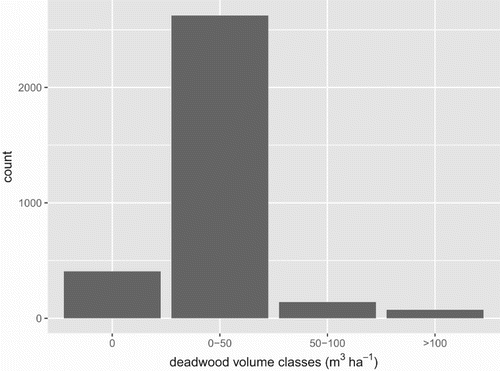
The volume, expressed in m3 of all deadwood elements, was summed up at plot level and scaled to m3 ha−1. In the map, these values were grouped in four classes: the first one relates to plots on which deadwood was not found (i.e. zero m3 ha−1). Plots with deadwood values ranging between 0 and 50 m3 ha−1, between 50 and 100 m3 ha−1 and higher than 100 m3 ha−1 were defined. The choice was due to the J-shaped distribution of deadwood volume (), which highlights the plots with no deadwood (12%) or volumes up to 50 m3 ha−1 (80%).
Figure 1. Frequency distribution (number of plots) against classes of total deadwood volume (m3 ha−1).
3. Conclusion
The aim of this paper was to present a large-scale distribution map of mean deadwood volume, as collected on 3243 plots over 19 European countries, along a spatially representative sampling design and adopting field standardized methods (Main Map).
This map is a methodological advance since is the first representation of the forest deadwood at a European continental scale, based on field surveys. The dataset allowed comparability of the collected parameters, so that the plot-based assessments of all the deadwood sources were expressed by a reasonable generalization of volume per area.
Quantitative representation highlights some general patterns. High concentration of plots with more than 50 m3 ha−1 of deadwood in the Alpine regions, including Carpathians and central Europe, draws attention on the possible linkage with high-forest management, while the commonly lower values in the Mediterranean region and South Great Britain can be linked to coppice management with a more continuous timber removal (e.g. CitationKirby, 1992). NW Great Britain, and Ireland, both with a non-native tree stands, suggest a country-based differentiation due to management policies. Almost regular dispersed plots with high deadwood amount, on a matrix of forest plots with reduced volumes, are to be found in N-Europe-Scandinavia, as a possible management strategy.
This map represents a good reference for scientists, land planners, forest managers and decision-makers at a Continental scale.
Extensive field knowledge helps improve classification accuracy of modelling derived assessments at large scale (e.g. CitationShrestha & Zinck, 2001; CitationTomppo et al., 2008). Moreover, being based on field assessments on the large-scale representative bases, the presented map per se is a benchmark to further monitoring of forest deadwood content, and for stratified sampling designs.
Deadwood is used as an indicator of naturalness (or forest health), or the evolution of large-scale forest biodiversity, to evaluate the trade-off between biodiversity and productivity, and represent a structural character in relations with local drivers, or for restoration and conservation perspectives (CitationBranquart, Verheyen, & Latham, 2008).
The map allows to allocate deadwood figures according to the ecogeographic context (e.g. biomes, ecological regions, forests types, etc.) as well as the management policies in different Countries or areas (CitationHekkala et al., 2016; CitationKorjus & Laarmann, 2015; CitationLassauce et al., 2011; CitationMerganičová, Merganič, Svoboda, Bače, & Šebeň, 2012; CitationRondeux & Sanchez, 2010).
Moreover, standardized values of forest attributes (like e.g. deadwood), as well as associated maps, are expected to fill the current gap between forest monitoring and biodiversity conservation purposes within policy and governance processes from local to European scale (e.g. CitationBarbati, Marchetti, Chirici, & Corona, 2014).
Software
R (CitationR CoreTeam, 2016) was used for computations and main statistical analysis. The map was performed using Quantum GIS (QGIS) and Inkscape.
Forest_deadwood_in_EU_03_PDF.pdf
Download PDF (2.1 MB)Acknowledgements
We would like to thank Janusz Czerepko and Radek Gawyrsz from Forest Research Institute (IBL, Poland) for their support.
Disclosure statement
No potential conflict of interest was reported by the authors.
ORCID
Nicola Puletti http://orcid.org/0000-0002-2142-959X
Francesca Giannetti http://orcid.org/0000-0002-4590-827X
Gherardo Chirici http://orcid.org/0000-0002-0669-5726
Roberto Canullo http://orcid.org/0000-0002-9913-6981
Related Research Data
References
- Barbati, A., Marchetti, M., Chirici, G., & Corona, P. (2014). European forest types and forest Europe SFM indicators: Tools for monitoring progress on forest biodiversity conservation. Forest Ecology and Management, 321, 145–157. doi: 10.1016/j.foreco.2013.07.004
- Branquart, E., Verheyen, K., & Latham, J. (2008). Selection criteria of protected forest areas in Europe: The theory and the real world. Biological Conservation, 141, 2795–2806. doi: 10.1016/j.biocon.2008.08.015
- Burkhard, B., Kroll, F., Nedkov, S., & Müller, F. (2012). Mapping ecosystem service supply, demand and budgets. Ecological Indicators, 21, 17–29.
- Canullo, R. (2016). The ICP forest level I BioDiversity data. A harmonized data source and baseline for plant species and structural diversity on European forest ecosystems. In A. Michel & W. Seidling (Eds.), Forest condition in Europe: 2016 Technical Report of ICP Forests. Report under the UNECE Convention on Long-Range Transboundary Air Pollution (CLRTAP) (BFW-Dokumentation 23: 9–105). Vienna: BFW Austrian Research Centre for Forests. Retrieved from https://www.icp-forests.org/pdf/TR2016.pdf
- Crecente-Campo, F., Pasalodos-Tato, M., Alberdi, I., Hernández, L., Ibañez, J. J., & Cañellas, I. (2016). Assessing and modelling the status and dynamics of deadwood through national forest inventory data in Spain. Forest Ecology and Management, 360, 297–310. doi: 10.1016/j.foreco.2015.10.029
- FCCC. (2015). Retrieved from http://unfccc.int/resource/docs/2015/cop21/eng/l09r01.pdf
- Ferretti, M., & Fischer, R. (2013). Forest monitoring: Methods for terrestrial investigations in Europe with an overview of North America and Asia (Developments in Environmental Science, Vol. 12, pp. 507). Oxford: Elsevier.
- Forest Europe. (2015). State of Europe’s Forests 2015. Retrieved from http://www.foresteurope.org/docs/fullsoef2015.pdf
- Hauβmann, T., & Fischer, R. (2004). The forest monitoring programme of ICP forest – a contribution to biodiversity monitoring. In M. Marchetti (Ed.), Monitoring and indicators of forest biodiversity in Europe – from ideas to operationality (Vol. 51, pp. 413–419). Joensuu: European Forest Institute.
- Hekkala, A.-M., Ahtikoski, A., Päätalo, M.-L., Tarvainen, O., Siipilehto, J., & Tolvanen, A. (2016). Restoring volume, diversity and continuity of deadwood in boreal forests. Biodiversity and Conservation, 25(6), 1107–1132. doi: 10.1007/s10531-016-1112-z
- JRC. (2011). Evaluation of BioSoil demonstration project: Forest biodiversity. Luxembourg: Publications Office of the European Union. doi: 10.2788/84823
- Kirby, K. J. (1992). Accumulation of dead wood: A missing ingredient in coppicing? In G. P Buckley (Ed.), Ecology and management of coppice woodlands (pp. 99–112). London: Chapman and Hall.
- Korjus, H., & Laarmann, D. (2015). Deadwood flow characteristics as an indicator of forest ecosystem naturalness. Forest Research, 4(2), e118. doi: 10.4172/2168-9776.1000e118
- Köhl, M., Traub, B., & Paivinen, R. (2000). Harmonisation and standardisation in multi-national environmental statistics-mission impossible? Environmental Monitoring and Assessment, 63, 361–380. doi: 10.1023/A:1006257630216
- Lassauce, A., Paillet, Y., Jactel, H., & Bouget, C. (2011). Deadwood as a surrogate for forest biodiversity: Meta-analysis of correlations between deadwood volume and species richness of saproxylic organisms. Ecological Indicators, 11(5), 1027–1039. doi: 10.1016/j.ecolind.2011.02.004
- Lombardi, F., Marchetti, M., Corona, P., Merlini, P., Chirici, G., Tognetti, R., … Puletti, N. (2015). Quantifying the effect of sampling plot size on the estimation of structural indicators in old-growth forest stands. Forest Ecology and Management, 346, 89–97. doi: 10.1016/j.foreco.2015.02.011
- Merganičová, K., Merganič, J., Svoboda, M., Bače, R., & Šebeň, V. (2012). Deadwood in forest ecosystems. In J. A. Blanco, & Y. H. Lo (Eds.), Forest ecosystems – more than just trees (pp. 81–108). InTech publisher. Retrieved from www.intechopen.com/books/forest-ecosystems-more-than-just-trees
- Pedrotti, F. (2013). Plant and vegetation mapping (Geobotany studies, pp. 294). Berlin: Springer.
- R Core Team. (2016). R: A language and environment for statistical computing. Vienna: R Foundation for Statistical Computing. Retrieved from https://www.R-project.org/
- Rondeux, J., & Sanchez, C. (2010). Review of indicators and field methods for monitoring biodiversity within national forest inventories. Core variable: Deadwood. Environmental Monitoring and Assessment, 164, 617–630. doi: 10.1007/s10661-009-0917-6
- Shrestha, D. P., & Zinck, J. A. (2001). Land use classification in mountainous areas: Integration of image processing, digital elevation data and field knowledge (application to Nepal). International Journal of Applied Earth Observation and Geoinformation, 3, 78–85. doi: 10.1016/S0303-2434(01)85024-8
- Ståhl, G., Cienciala, E., Chiric, I. G., Lanz, A., Vidal, C., Winter, S., … Tomppo, E. (2012). Bridging national and reference definitions for harmonizing forest statistics. Forest Science, 58(3), 214–223. doi: 10.5849/forsci.10-067
- Tomppo, E. O., & Schadauer, K. (2012). Harmonising national forest inventories in Europe: Advances under COST action E43. Forest Science, 56, 191–200. doi: 10.5849/forsci.10-091
- Tomppo, E., Olsson, H., Ståhl, G., Nilsson, M., Hagner, O., & Katila, M. (2008). Combining national forest inventory field plots and remote sensing data for forest databases. Remote Sensing of Environment, 112, 1982–1999. doi: 10.1016/j.rse.2007.03.032
- Travaglini, D., Barbati, A., Chirici, G., Lombardi, F., Marchetti, M., & Corona, P. (2007). ForestBIOTA data on deadwood monitoring in Europe. Plant Biosystems - An International Journal Dealing with all Aspects of Plant Biology, 141, 222–230. doi: 10.1080/11263500701401778
- Working Group on Forest Biodiversity. (2007). The BioSoil Forest Biodiversity field manual. In JRC 2011, Evaluation of BioSoil Demonstration Project: Forest biodiversity (pp. 81–102). Luxembourg: Publications Office of the European Union. doi: 10.2788/84823
- Zell, J., Kändler, G., & Hanewinkel, M. (2009). Predicting constant decay rates of coarse woody debris – a meta-analysis approach with a mixed model. Ecological Modelling, 220(7), 904–912. doi: 10.1016/j.ecolmodel.2009.01.020