
 ?Mathematical formulae have been encoded as MathML and are displayed in this HTML version using MathJax in order to improve their display. Uncheck the box to turn MathJax off. This feature requires Javascript. Click on a formula to zoom.
ABSTRACT
A severe rainfall event occurred in southern Calabria between 29 October and 2 November 2015, causing two deaths and serious damage to transport infrastructure. Widespread slope erosion and thousands of shallow landslides were triggered on the slopes, combined with flooding and transport of debris along the streams. Rains recorded by the regional gauge network and the national radar monitoring system were analysed by means of Kriging techniques. Ground effects were surveyed in the field, and mapped using post-event air photos taken along the coastal sector. Shallow landslides, soil erosion (including sheet, rill, and gully erosion), flooding, lateral erosion, and debris deposition along streambeds, overflow on lateral slopes, and fan deposition at the mouths of the streams were mapped at 1:60,000 scale. Isohyets of the rainfall event – in terms of cumulative maxima over 24 h – are also shown on the Main Map. In Annex A, a list of notices of processes and/or damage, arranged by municipalities, with coordinates, types of ground effect, and synthetic descriptions, is also provided.
1. Introduction
High-intensity rainfall is frequent in Calabria, with some days receiving amounts usually recorded in some months (CitationFerrari & Terranova, Citation2004; CitationTerranova & Gariano, Citation2014). Such rainfall events commonly induce significant geomorphic effects on slopes and along streams, and can cause deaths and severe damage to anthropic areas (CitationCapparelli, Iaquinta, Iovine, Terranova, & Versace, Citation2012; CitationConforti, Muto, Rago, & Critelli, Citation2014; CitationGullà, Antronico, Iaquinta, & Terranova, Citation2008; CitationIovine & Merenda, Citation1996; CitationIovine & Petrucci, Citation1998; CitationIovine, Iaquinta, & Terranova, Citation2009; CitationSorriso-Valvo et al., Citation2004; CitationTerranova et al., Citation2016; CitationVennari et al., Citation2014). There is thus an urgent need for detailed studies aimed at ‘geo-hydrological’ hazard mapping (i.e. ground effects caused by meteorological phenomena, distinguished into hydraulic, landslide, and groundwater categories – sensu CitationCanuti, Casagli, Pellegrini, & Tosatti, Citation2001) and risk management.
Among the major historic events occurred in Calabria, those of 12–18 October 1951 and 21 October 1953 caused widespread damage, deaths, and injuries in the southern part of the region (CitationAntronico, Coscarelli, & Terranova, Citation2005; CitationBotta, Citation1977; CitationCaloiero & Mercuri, Citation1980; CitationCatenacci, Citation1992). During the 1951 event, 1770 mm fell in 6 days on the Aspromonte massif, and 535 mm in 24 h at Santa Cristina d’Aspromonte (for the location of places mentioned in the text, see and Main Map). Seventy-seven municipalities were affected, mainly along the southern Ionian sector, causing 70 deaths and leaving 4500 homeless. About 1700 dwellings and 26 bridges were destroyed, aqueducts suffered damage in several locations, and some urban centres had to be abandoned (new settlements had to be built on safer places). Reggio di Calabria (the most affected province) suffered over 15.5 M€ damage. During the 1953 event, 362 mm of rain were recorded at Badolato, and 315 mm at Stilo in just few hours. The event caused 200 deaths, many injured, and thousands of homeless (4000 of them in Reggio di Calabria).
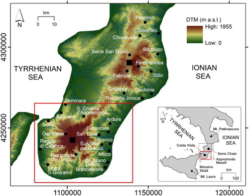
Figure 1. Location of southern Calabria (grey rectangle) and Sicily. The red square marks the limits of the study area. The main stream network (cf. blue lines) and toponyms mentioned in the text are also shown. Black triangles mark radar locations at Mt. Pettinascura and Mt. Lauro. Black squares show locations of Aspromonte massif and Serre mountain chain.
Further heavy events struck southern Calabria, causing deaths and damage on several occasions (CitationGullà et al., Citation2009; CitationTerranova et al., Citation2013; CitationTerranova & Gariano, Citation2014). Among the most severe, maximum daily rainfall up to 306.6 mm was recorded at Palermiti between 9 September and early October 2000. During the same period, rainfall in 3 days exceeded 630 mm at Ferdinandea, and 560 mm at Caulonia and Chiaravalle Centrale. The event triggered widespread shallow landslides and flooding, with damage recorded mainly along the Ionian coast where 13 people were killed by a flood along the Soverato stream (CitationAntronico, Gullà, & Terranova, Citation2002; CitationSorriso-Valvo et al., Citation2004). More recently, another event hit southern Calabria between 29 October and 2 November 2015, causing two deaths and serious damage to infrastructure. The affected area is crossed by regional transport lines and hosts numerous villages, in addition to the town of Reggio di Calabria facing the Messina Strait. Widespread geomorphic effects were caused by the heavy rains: slope erosion and shallow landslides were triggered on the slopes; streams flooded and caused breaking of banks and bridges due to debris transport; the state road (SS.106) and the railroad remained closed for days; electricity, telecommunications, water and sewage networks were also damaged at several locations. A couple of days after the event, a ‘state of emergency’ was requested from the National Government, based on an overall estimate for remedial works and mitigation actions exceeding 322 M€ (CitationRegione Calabria, Citation2015), including over 58 M€ for immediate rescue, mitigation actions, and assistance to population. On 3 March 2016, the Italian Government declared a state of calamity, allocating 11.8 M€ for immediate rescue actions. A few days later, an order concerning damage to farms was signed by the Minister of Agriculture and Forestry.
In this study, this latter rainfall event and its geomorphic effects in southern Calabria are briefly described. Induced erosive and gravitational processes are synthesized in an inventory map, including notices from field inspections and isohyets derived from combined rain gauge and radar data.
2. Study area
The Calabrian Arc, in southern Italy, is an accretionary wedge caused by the Africa–Europe collision (CitationAmodio-Morelli et al., Citation1976; CitationTortorici, Citation1982). It is a series of ophiolite-bearing tectonic units and overlying basement nappes, piled up by prolonged orogenic phases started between the Cretaceous and the Late Eocene. Since the Miocene, overthrusting has been associated with a regional strike-slip tectonic regime, whilst in the Late Pliocene-Early Quaternary an extensional phase caused fragmentation of the Arc. In the Middle Pleistocene, a regional strike-slip phase started, originating the ‘Calabrian-Sicilian rift-zone’ along the western side of the Arc, coupled with strong regional uplifting (CitationMonaco, Tapponnier, Tortorici, & Gillot, Citation1997; CitationTansi, Muto, Critelli, & Iovine, Citation2007).
The study area is in the coastal sector of the southern portion of the Arc. It is characterized by a pile of crystalline nappes, including metamorphic and plutonic rocks, and related Meso-Cenozoic sedimentary sequences (CitationTortorici, Citation1982). Due to the complex tectonic history of the Arc, the rocks of the basement are diffusely fractured and weathered, with regolith depths up to 10s or even 100s of metres (CitationGuzzetta, Citation1974; CitationLe Pera & Sorriso-Valvo, Citation2000). These low-resistance materials are combined with high relief, produced by recent and active tectonics, and by slope erosion.
On Fig. A (on Main Map), lithological outcrops of southern Calabria are combined in nine classes, based on litho-technical properties (CASMEZ, Citation1969). In the study area (i.e. in the coastal sector), outcrops of clastic materials (mainly alluvium, colluvium, and residual soils, followed by clay and clayey flysch, conglomerate and sandstone, and sand and silt) dominate (> 90%), igneous and medium–high-grade metamorphic rocks follow (∼7.4%), with minor extents of the remaining lithotypes. Rock classes are not uniformly distributed. Igneous and medium–high-grade metamorphic rocks, and conglomerate and sandstone, crop out mainly along the western coast, clay and clayey flysch is mainly found along the southern and eastern coast, and alluvial deposits are common, except for the Costa Viola sector in the NW.
On Fig. B (on Main Map), slope values are displayed in five classes, based on Jenks natural breaks method. In the study area, ‘very low’ to ‘low’ slope values account for about 66%; less than 18% of the area shows ‘high’ to ‘very high’ slope values. As with lithology, slope classes are not uniformly distributed. Gentler slopes occur mainly in the Ionian coastal sector, whereas steeper slopes are found on the Costa Viola.
3. Methods
Rain data were derived from the regional gauge network and from the national radar monitoring system. In particular, rainfall recorded by the Regione Calabria-ARPACAL (Regional Agency for the Protection of the Environment in Calabria) – Functional Centre, with time step of 1 min, provided a total of 156 observation points over the entire Calabrian territory (∼15,150 km2). Meteorological radar data (in C band, ∼5 GHz) provided by the National Civil Protection was also used. Suitable instruments are at Mt. Pettinascura (1725 m a.s.l., long. 16.618 E, lat. 39.370 N), and in Sicily, at Monte Lauro (980 m a.s.l., long. 14.836 E, lat. 37.116 N) – for radar locations, see . With a time step of 10 min, radar measurements of the Italian network are processed on a 1 km2 square grid to obtain Surface Rainfall Intensity values (SRI, [mm h−1]), by means of a standard Marshall and Palmer Z–R relation (CitationVulpiani et al., Citation2008; Citation2012).
By considering the usual dimensions of smaller rainstorm cells (cf. CitationHarrold & Austin, Citation1974), a 1 km-size square mesh was adopted for an estimation of the rainfall distribution. Cumulative rainfall, measured by the gauge network between 00:00 on 29 October (t1) and 09:00 on 2 November (t2), was then calculated by Ordinary Kriging (OK estimates, ). Radar and rain gauge information were then merged in R (a free software environment for statistical computing and graphics, cf. https://www.r-project.org/) to obtain cumulative rainfall by means of a Universal Kriging regression technique with an external-drift algorithm (UK estimates,
). For both OK and UK estimates, the interpolation processes were performed by the ‘autoKrige’ functions implemented in the Automap and Gstat libraries of R (CitationHiemstra, Citation2015; CitationHiemstra, Pebesma, Twenhöfel, & Heuvelink, Citation2009). As a way of investigating the amounts of rain deemed responsible for the observed types of ground effects, and considering the extent of the affected basins, the maximum amounts of UK cumulative rainfall in 24 h between t1 and t2,
, were also extracted for each cell of the domain. In fact, shallow landslides, flash floods and slope erosion commonly result strongly related to high intensity, short duration rainfall events (Cascini & Versace, Citation1986, Citation1988; Terranova & Gariano, Citation2014; Terranova, Gariano, Iaquinta, & Iovine, Citation2015).
Ground effects caused by the Autumn 2015 rainfall event in the study area were surveyed by combined air-photo interpretation and site investigations. Immediately after the storm, colour air-photographs (scale 1:22,000) were taken along the coastal sector of southern Calabria, between Roccella Jonica and Seminara, covering a strip 4–6 km wide. Surveyed ground effects were obtained from notices of site investigations carried out by a team coordinated by the regional Civil Protection (Regione Calabria, Citation2015). Air-photo interpretation was used to map processes induced by the rainfall event – i.e. soil erosion, slope movements, and hydraulic phenomena along the streambeds down to the coast. In more detail, the following processes were taken into account: (i) shallow landslides (including sources areas, transport, and deposition zones); (ii) soil erosion on slopes (including sheet, rill, and gully erosion); (iii) flooding, lateral erosion, and debris deposition along the streambeds, overflow on lateral slopes, and fan deposition by the coast.
4. Results
4.1. The rainfall event
The severe rainfall event that struck southern Calabria between 29 October and 2 November 2015 was concentrated on the Aspromonte massif and the eastern slopes of the Serre mountain chain. Based on gauge data, more than 746 mm of rain were recorded at Chiaravalle Centrale, and 605 mm at S. Agata del Bianco (at the same sites, annual average rainfalls are 1446.6 mm and 1065 mm, respectively). Between 31 October and 1 November, the study area received more than half of the annual average rainfall. On 1 November, 370.4 mm were recorded at S. Agata del Bianco, and 364.4 mm at Chiaravalle Centrale. The coastal sector was also affected, although with lower intensities.
UK and OK estimates of the total amount of rain between t1 and t2, as obtained by Kriging interpolations, are shown in Figs. C(a) and C(b) (on Main Map); a cell-by-cell comparison of the above estimates is also provided in Fig. C(c). Two zones appear to be most affected by rainfall. The first is along the Serre mountain chain, between Chiaravalle Centrale, Serra San Bruno, Fabrizia, and Badolato (i.e. just north of the area here described), and the second is on the Aspromonte massif, between Gambarie, Roccaforte del Greco, Bruzzano, and San Luca. The difference map between UK and OK estimates ) shows that the greatest values (> 250 mm) are on the Serre mountain chain, between Chiaravalle Centrale, Serra San Bruno, Fabrizia, and Badolato. UK estimates indicate higher rainfall maxima with respect to OK, with a maximum of 818 mm about 14 km south of Chiaravalle Centrale (at the same site, OK values are ∼70% of UK). Other notable discrepancies (up to 73 mm) can be recognized in the Aspromonte massif (between Gambarie, Roccaforte del Greco, Bruzzano, and San Luca), where OK values are ∼86% of UK. Here, according to UK estimates, the area most severely hit by rainfall is larger and more continuous with respect to OK estimates. In Fig. C(d), the distribution of the above differences in terms of elementary and cumulative frequencies shows that:
only 10% of the cells are characterized by similar rainfall amounts;
in about 25% of the cells, differences are smaller than 10 mm;
in 10% of the cells, rain amounts were overestimated by OK (from 10 to 70 mm);
in 67% of the cells, rain amounts were underestimated by OK (from 10 to 250 mm).
The UK map of the is shown in Fig. D (cf. Main Map). The highest values roughly correspond to maxima of
shown in Fig. D(a), and are located some distance from the available rain gauges of the regional network.
4.2. Induced ground effects
Widespread shallow slope movements, soil erosion on the slopes, and flooding triggered by the Autumn 2015 rains were recognized along the coastal sector of southern Calabria, between Roccella Jonica (on the Ionian side), and Seminara (on the Tyrrhenian side). As a whole, about 8100 shallow landslides were mapped, affecting a total area of about 1.3 × 10⁶ m2, and resulting in an average extent of ∼163 m2. About 67% of slope movements activated along the Ionian sector of the study area, between Roccella Ionica and Brancaleone; only 8% were triggered along the southernmost portion of Calabria, between Brancaleone and Motta S. Giovanni; the remaining 25% of cases affected the Tyrrhenian coast, between Motta S. Giovanni and Seminara. The density of triggered landslides is shown in Fig. E (on Main Map), together with isohyets of . Greatest landslide densities are found along the eastern coast between Bianco and Africo (22–47 sources per hectare), with notable amounts between Benestare and Ardore (10–21 sources per hectare), roughly corresponding to
of 400–450 mm. Remarkable landslide densities (10–21 sources per hectare) are also found in the vicinity of Reggio di Calabria, despite being characterized by lower rainfall amounts (
= 150 mm).
Triggered slope movements are mostly soil slips (sensu CitationCampbell, Citation1975), mainly of translational type, that mobilized coarse soils from the regolith cover. Debris slides frequently fluidized into flows during propagation along slopes and channels. Accordingly, they could either be ascribed to debris flows or debris avalanches (cf. channelled vs. open-slope cases – CitationCruden & Varnes, Citation1996; CitationHungr, Leroueil, & Picarelli, Citation2014; CitationSharpe, Citation1938).
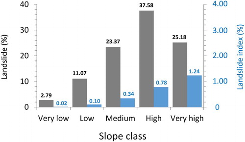
The frequency distribution of landslide extent is shown in . Most of the triggered slope movements are of small size. More than 55% of the cases are smaller than 100 m2, and only 1.5% exceeds 1000 m2. Furthermore, clay and clayey flysch crop out in more than half of the area affected by shallow landslides, followed by sand and silt, conglomerate and sandstone, and igneous and medium-high grade metamorphic rock (). Nevertheless, if the relative extent of the different lithological classes is also taken into account, greater ‘landslide indices’ characterize flysch outcrops, followed by clay and clayey flysch and igneous and medium-high grade metamorphic rock. Most of the landslides developed in the high slope class, followed by the very high and medium classes. On the other hand, the landslide index shows an increasing trend from very low to very high slope values ().
Figure 2. Cumulative frequency (%) of the extent of shallow landslides mobilized by the Autumn 2015 rainfall event in the study area.
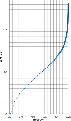
Figure 3. Areal distribution of shallow landslides triggered by the Autumn 2015 event with respect to lithological classes (in grey, ratio of landslide area in a given lithotype to total landslide area, in %), and landslide indices for the same types of outcrops (in blue, ratio of landslide area in a given lithotype to total area of the same lithotype, in %). Key: (a) Alluvium, colluvium and residual soil; (b) Clay and clayey flysch; (c) Sand and silt; (d) Conglomerate and sandstone; (e) Evaporite rock; (f) Flysch; (g) Carbonate rock; (h) Argillite and low-grade metamorphic rock; (i) Igneous and medium-high grade metamorphic rock.
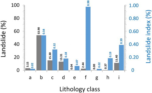
Figure 4. Areal distribution of shallow landslides triggered by the Autumn 2015 event with respect to slope classes (in grey), and landslide indices against the same slope classes (in blue). Values of areal distribution and indices are computed similarly to .
In addition to gravitational processes, about 1.2 × 10⁶ m2 suffered from sheet erosion, including 0.3 × 10⁶ m2 also affected by rill development. Gullies were activated for a total length of about 83 km (min: 2.6 m; max: 501 m; average: 73 m; standard deviation: 69.3). Areas affected by either sheet or rill erosion (in places, combined with gullies) were mostly located in the Ionian sector (66%), and smaller areas in the Tyrrhenian (19%) and in the southernmost (15%) portions of the study area. Widespread effects were observed along the streambeds, with flow diversions, flooding, and/or sedimentation that also caused appreciable morphological changes along the coastline, where alluvial fans developed at the mouths of the streams.
Ground effects caused widespread damage on slopes and along streambeds, down to the coastline. Common types of damage range from soil disruption (due to either shallow landslides or erosion), to embankment piping or breaks, flooding and debris deposition along the streams, in some locations causing blockage of bridges and destruction of roads or railway lines. If comparing the distribution of landslide sources with isohyets (), greater landslide indices – and related damage – roughly correspond with higher rainfall amounts. A summary of surveyed types of damage notices/ground effects surveyed by CitationRegione Calabria (Citation2015) is listed in .
Figure 5. Areal distribution of shallow landslides triggered by the Autumn 2015 event with respect to classes of (in grey), and landslide indices against the same
classes (in blue). Values of areal distribution and indices are computed similarly to .
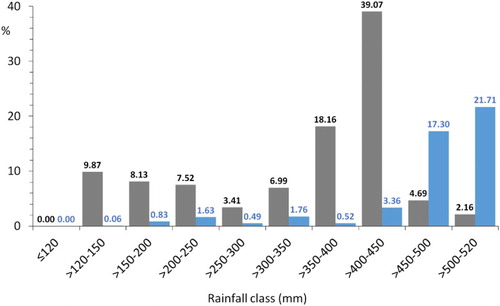
Table 1. Summary of types of damage notices and ground effects surveyed in the study area (after CitationRegione Calabria, Citation2015, mod.).
On the Main Map at 1:60,000 scale, the surveyed ground effects induced in the study area by the Autumn 2015 rainfall event are shown, together with the isohyets of . The boundaries of the surveyed area are limited by the extent of post-event air-photo coverage. Note that, due to scale limitations (cf. extent of the study area and of average mapped phenomena), landslides are only symbolically shown. Furthermore, notices of processes and/or damage – as reported by CitationRegione Calabria (Citation2015) – are mapped by a series of suitable pink symbols to exemplify all possible combinations of hydraulic processes (A), slope movements (B), and damage/remedial works (C). Occurrences of the same notices are summarized in : the complete list, arranged by municipalities, is reported as supplementary material (Annex A) with coordinates of the sites of investigation, types of observed ground effect/damage, and descriptions. Finally, some photographic examples of surveyed ground effects are shown on the Main Map (locations of the sites are shown by means of brown circles linked to the photos).
Table 2. Types of damage notices/ground effects surveyed in the study area (after CitationRegione Calabria, Citation2015, mod.).
5. Discussion and conclusion
The ground effects induced by the Autumn 2015 rainfall event in southern Calabria were surveyed and mapped, together with the isohyets obtained by analysing gauge and radar data. According to UK estimates, two zones were most affected by the rainfall along the Ionian side of southern Calabria from 29 October to 2 November. The first, along the Serre mountain chain, and the second on the Aspromonte massif. UK-estimated results were appreciably higher than those obtained via OK. These discrepancies confirmed that gauge networks could be unsuitable for capturing rainfall distribution in convective storms. If maxima in 24 h, instead of total amounts, are taken into account, the sectors mainly affected by the rainfall do not significantly change; a similar result is obtained by considering maxima aggregated at 3, 6, 12, and 48 h. In this case, the aggregation period has therefore only a small influence on the rainfall pattern.
Ground effects totalled an area of 2.5 km2: they consist of thousands of shallow landslides (debris slides of small size, fluidized in 2/3 of the cases into debris flows or avalanches), mainly triggered on higher-slope classes and sedimentary outcrops, and of soil erosion processes. In addition, flooding occurred along the main streams, with debris deposition along the channels and by the coast. About 2/3 of the soil slips originated in the Ionian coastal sector, followed by the Tyrrhenian (1/4), with only minor occurrences along the southernmost portion of the study area. A similar spatial pattern characterized areas affected by soil erosion.
When comparing the density of triggered landslides to the isohyets of , greatest landslide densities are found along the eastern coast (between Bianco and Africo, and between Benestare and Ardore), roughly corresponding to 400–450 mm of rainfall. Remarkable landslide densities are also found in the vicinity of Reggio di Calabria, despite characterized by lower rainfall amounts (150 mm). The above discrepancy seems to point out quite heterogeneous susceptibility conditions to initiation of shallow landslides in the study area. In other words, similar rainfall amounts may or may not trigger shallow landslides in different sectors of southern Calabria, depending on their interplay with the predisposing factors (e.g. lithotype, steepness, soil type, land use). For instance, despite receiving higher rainfall amounts, only minor ground effects were recorded in the Serre mountain chain compared to the Aspromonte massif. This difference could be explained by taking into account the gentler morphological setting that characterizes most of the Serre area struck by the storm. Consequently, hydrological studies aimed at estimating shallow-landslide thresholds should be focused mainly on homogeneous environmental sectors rather than at regional scale (e.g. CitationVennari et al., Citation2014). Further analyses are presently being performed to refine rainfall thresholds in the study area, based on mapped phenomena and by considering different aggregation periods.
Software
Mapping was carried out using Esri ArcMap 10.1; minor editing was performed by using Adobe Photoshop CS5.
Geolocation information
Calabria, southern Italy.
Supplementary_files.zip
Download Zip (37.3 MB)Acknowledgements
Rain data were made available by the Regione Calabria, ARPACAL-Functional Centre, within the frame of the RAMSES Project, in agreement with RFI S.p.A. (Italian Railway Network), CNR-IRPI and CNR-ISAC (Institute of Atmospheric Sciences and Climate). Post-event air-photos were provided by the Basin Authority of Calabria. The study was partly carried out within the RAMSES and the ALFORLAB – Public Private Laboratory – projects. Authors are grateful to the Associate Editor (Colin Pain) and to the three referees (Samuele Segoni, Giedrė Beconytė, and Francesco Faccini) for their comments that allowed us to improve the original version of the manuscript.
Disclosure statement
No potential conflict of interest was reported by the authors.
ORCID
Oreste G. Terranova http://orcid.org/0000-0001-8211-8261
Giulio G. R. Iovine http://orcid.org/0000-0002-8023-2973
Related Research Data
References
- Amodio-Morelli, L., Bonardi, G., Colonna, V., Dietrich, D., Giunta, G., Ippolito, F., … Zuppetta, A. (1976). L’arco Calabro-Peloritano nell’orogene appenninico Maghrebide [The Calabrian-Peloritan Arc in the Apennine-Maghrebide orogen]. Memorie della Societa Geologica Italiana, 17, 1–60.
- Antronico, L., Coscarelli, R., & Terranova, O. (2005). Surface erosion assessment in two Calabrian basins (southern Italy). In R. J. Batalla, & C. Garcia (Eds.), Geomorphological processes and human impacts in river basins. Proceedings of the International Conference held at Solsona (pp. 16–22). Catalonia: IAHS Publ. 299. May 2004, ISBN: 1-901502-28-7.
- Antronico, L., Gullà, G., & Terranova, O. (2002, June). L’evento pluviometrico dell’8–10 settembre 2000 nella Calabria Ionica meridionale: dissesti sui versanti e processi in alveo [The pluviometric event of 8–10 September 2000 in southern Ionian Calabria: Slope instabilities and processes along the streams]. Proceedings of the Conference ‘Il Dissesto Idrogeologico: Inventario e Prospettive’ (pp. 67–79), June 5, 2001, Roma. Rome: Accademia Nazionale dei Lincei.
- Botta, G. (1977). Difesa del suolo e volonta politica: Inondazioni fluviali e frane in Italia (1946–1976) [Soil defence and politics: Floods and landslides in Italy (1946–1976)]. Milano: F. Angeli.
- Caloiero, D., & Mercuri, T. (1980) Le alluvioni in Calabria dal 1921 al 1970 [Floods in Calabria between 1921 and 1970]. Geodata, 36, 53 pp. Cosenza: CNR-IRPI.
- Campbell, R. H. (1975). Soil slips, debris flows, and rainstorms in the Santa Monica mountains and vicinity, Southern California ( U.S. Geological Survey, Professional Paper 851, 51 pp.). Washington, DC: U.S. Gov. Printing Office.
- Canuti, P., Casagli, N., Pellegrini, M., & Tosatti, G. (2001). Geo-hydrologcal hazards. In G. B. Vai & I. P. Martini (Eds.), Anatomy of an Orogen: The Apennines and adjacent Mediterranean basins (pp. 513–532). Dordrecht: Kluwer Academic. doi:10.1007/978-94-015-9829-3_28
- Capparelli, G., Iaquinta, P., Iovine, G., Terranova, O. G., & Versace, P. (2012). Modelling the rainfall-induced mobilization of a large slope movement in Northern Calabria. Natural Hazards, 61(1), 247–256. doi: 10.1007/s11069-010-9651-1
- Cascini, L., & Versace, P. (1986, May 14–16). Eventi pluviometrici e movimenti franosi [Rainfall events and slope movements].Proceedings of XVI national conference of geotechnics (pp. 171–184), Bologna. SBN: CFI0020828, BNI: 87-6815
- Cascini, L., & Versace, P. (1988). Relationship between rainfall and landslide in a gneissic cover. Proceedings of the 5th International Symposium on Landslides (pp. 565–570), Lausanne. ISBN: 9061918383.
- CASMEZ. (1969). Carta Geologica della Calabria in scala 1:25,000 [Geological map of Calabria at 1:25,000 scale]. Ercolano: Poligrafica & Cartevalori.
- Catenacci, V. (1992). Il dissesto idrogeologico e geoambientale in Italia dal dopoguerra al 1990 [Geo-hydrological and environmental instability in Italy since 1990]. Mem. Descrittive della Carta Geologica d'Italia. Cronistorie Calabresi (pp. 228–245). Roma: Servizio Geologico Nazionale, Ist. Poligrafico e Zecca dello Stato.
- Conforti, M., Muto, F., Rago, V., & Critelli, S. (2014). Landslide inventory map for north-eastern Calabria (South Italy). Journal of Maps, 10, 90–102. doi: 10.1080/17445647.2013.852142
- Cruden, D. M., & Varnes, D. J. (1996). Landslide types and processes. In Landslides: Investigation and mitigation (Special Report 247, pp. 36–75). Washington, DC: Transportation Research Board, National Academy of Sciences.
- Ferrari, E., & Terranova, O. (2004). Non-parametric detection of trends and change point years in monthly and annual rainfalls. Proceedings of 1st Italian-Russian Workshop New Trends in Hydrology (Publ. 2823, pp. 177–188). Roma: CNR.
- Gullà, G., Antronico, L., Borrelli, L., Caloiero, T., Coscarelli, R., Iovine, G., … Terranova, O. (2009). Indicazioni conoscitive e metodologiche connesse all’evento di dissesto idrogeologico dell’autunno-inverno 2008-2009 in Calabria [Considerations on the geo-hydrological event of Atumn-Winter 2008-2009 in Calabria]. Geologi Calabria, 10(1), 4–21.
- Gullà, G., Antronico, L., Iaquinta, P., & Terranova, O. (2008). Susceptibility and triggering scenarios at a regional scale for shallow landslides. Geomorphology, 99(1), 39–58. doi: 10.1016/j.geomorph.2007.10.005
- Guzzetta, G. (1974). Ancient tropical weathering in Calabria. Nature, 251(5473), 302–303. doi: 10.1038/251302a0
- Harrold, T. W., & Austin, P. M. (1974). The structure of precipitation systems – a review. Journal de Recherches Atmospheriques, 8(1–2), 41–57.
- Hiemstra, P. H., Pebesma, E. J., Twenhöfel, C. J., & Heuvelink, G. B. (2009). Real-time automatic interpolation of ambient gamma dose rates from the Dutch radioactivity monitoring network. Computers & Geosciences, 35(8), 1711–1721. doi: 10.1016/j.cageo.2008.10.011
- Hiemstra, P. H. (2015). CRAN – package automap. Retrieved from http://cran.r-project.org/web/packages/automap/automap.pdf
- Hungr, O., Leroueil, S., & Picarelli, L. (2014). The Varnes classification of landslide types, an update. Landslide, 11(2), 167–194. doi: 10.1007/s10346-013-0436-y
- Iovine, G., Iaquinta, P., & Terranova, O. (2009, July 13–17). Emergency management of landslide risk during Autumn-Winter 2008/2009 in Calabria (Italy). The example of San Benedetto Ullano. In R. S. Anderssen, R. D. Braddock, & L. T. H. Newham (Eds.), Proceedings of the 18th World IMACS congress and MODSIM09 international congress on modelling and simulation (pp. 2686–2693). Nedlands, WA: University of Western Australia. ISBN: 978-0-9758400-7-8.
- Iovine, G., & Merenda, L. (1996). Nota illustrativa alla ‘Carta delle frane e della mobilizzazione diastrofica, dal 1973 ad oggi, nel bacino del Torrente Straface (Alto Jonio, Calabria)’ [Notes to the ‘Map of landslides since 1973 in the Torrente Straface basin (Alto Jonio, Calabria)’]. Geologia Applicata e Idrogeologia, 31, 107–128.
- Iovine, G., & Petrucci, O. (1998). Effetti sui versanti e nel fondovalle indotti da un evento pluviale eccezionale nel bacino di una fiumara calabra (T. Pagliara) [Ground effects along the slopes and the main stream caused by an exceptional meteoric event in the basin of a Calabrian fiumara (T. Pagliara)]. Bollettino della Società Geologica Italiana (Italian Journal of Geosciences), 117, 821–840.
- Le Pera, E., & Sorriso-Valvo, M. (2000). Weathering and morphogenesis in a Mediterranean climate, Calabria, Italy. Geomorphology, 34(3–4), 251–270. doi: 10.1016/S0169-555X(00)00012-X
- Monaco, C., Tapponnier, P., Tortorici, L., & Gillot, P. Y. (1997). Late Quaternary slip rates on the Acireale-Piedimonte normal faults and tectonic origin of Mt. Etna (Sicily). Earth and Planetary Science Letters, 147, 125–139. doi: 10.1016/S0012-821X(97)00005-8
- Regione Calabria (2015). Rapporto di evento. Precipitazioni del 30 ottobre – 2 novembre 2015 [Event report – Rainfall of 30 October – 2 November 2015]. Catanzaro: UOA Civil Protection & Basin Authority.
- Sharpe, C. F. S. (1938). Landslides and related phenomena. New York, NY: Columbia University Press.
- Sorriso-Valvo, M., Antronico, L., Gaudio, R., Gullà, G., Iovine, G., Merenda, G., … Terranova, O. (2004). Map of mass movement, erosion and flooding caused in south Calabria by the 8–10 September 2000 storms (Publication n. 2859). Roma: CNR-Gruppo Nazionale per la Difesa dalle Catastrofi Idrogeologiche.
- Tansi, C., Muto, F., Critelli, S., & Iovine, G. (2007). Neogene-Quaternary strike-slip tectonics in the central Calabrian Arc (Southern Italy). Journal of Geodynamics, 43, 393–414. doi: 10.1016/j.jog.2006.10.006
- Terranova, O. G., Gariano, S. L., Bruno, C., Greco, R., Pellegrino, A. D., & Iovine, G. G. R. (2016). Landslide-risk scenario of the Costa Viola mountain ridge (Calabria, Southern Italy). Journal of Maps, 12, 261–270. doi: 10.1080/17445647.2016.1195300
- Terranova, O. G., Gariano, S. L., Iaquinta, P., & Iovine, G. G. R. (2015). GASAKe: Forecasting landslide activations by a genetic-algorithm-based hydrological model. Geoscientific Model Development, 8, 1955–1978. doi: 10.5194/gmd-8-1955-2015
- Terranova, O. G., & Gariano, S. L. (2014). Rainstorms able to induce flash floods in a Mediterranean-climate region (Calabria, southern Italy). Natural Hazards and Earth System Sciences, 14, 2423–2434. doi: 10.5194/nhess-14-2423-2014
- Terranova, O. G., Iaquinta, P., Gariano, S. L., Iovine, G., Antronico, L., Vennari, C., … Guzzetti, F. (2013). Rainfall events able to trigger shallow landslides in Calabria (Southern Italy). Rendiconti Online Della Società Geologica Italiana, 24, 310–312.
- Tortorici, L. (1982). Lineamenti geologico-strutturali dell’Arco Calabro Peloritano [Geologic-structural lineaments of the Calabrian-Peloritan Arc]. Società Italiana di Mineralogia e Petrografia, 38, 927–940.
- Vennari, C., Gariano, S. L., Antronico, L., Brunetti, M. T., Iovine, G., Peruccacci, S., … Guzzetti, F. (2014). Rainfall thresholds for shallow landslide occurrence in Calabria, southern Italy. Natural Hazards and Earth System Sciences, 14(2), 317–330. doi: 10.5194/nhess-14-317-2014
- Vulpiani, G., Montopoli, M., Passeri, L. D., Gioia, A. G., Giordano, P., & Marzano, F. S. (2012). On the use of dual-polarized C-band radar for operational rainfall retrieval in mountainous areas. Journal of Applied Meteorology and Climatology, 51(2), 405–425. doi: 10.1175/JAMC-D-10-05024.1
- Vulpiani, G., Pagliara, P., Negri, M., Rossi, L., Gioia, A., Giordano, P., Alberoni, P.P., Cremonini, R., Ferraris, L., & Marzano, F. S. (2008, June 30–July 4). The Italian radar network within the national early-warning system for multi-risks management. Proceedings of Fifth European Conference on Radar in Meteorology and Hydrology (ERAD 2008) (p. 184). Helsinki: Finnish Meteorological Institute.