
ABSTRACT
In the northwestern part of Northern Apennines, between Curone and Staffora Valleys, the tectonic superposition between the External Ligurian Units (i.e. the ophiolitic-bearing chaotic complex of the Groppallo Unit and the non-ophiolitic Cassio Unit), the Middle Eocene – Miocene wedge-top basin Epiligurian Units succession, and the Late Messinian – Pliocene Po Plain succession, records the multistage tectono-stratigraphic evolution from subduction to continental collision. Our geological map, at the 1:20,000 scale, allows us to define 6 main tectonic stages on the basis of (i) the crosscutting relationships between main faults and local to regional stratigraphic unconformities and (ii) the differentiation among different types of chaotic rock unit (olistostromes and broken formations) deposited since Late Cretaceous to late Messinian. This approach provides a new understanding on the tectono-stratigraphic evolution of this sector, and its meaning in the evolution of the northwestern part of Northern Apennines.
1. Introduction
In the hanging wall of the Apenninic thrust front, the northwestern part of Northern Apennines belt (between Voghera and Piacenza) is characterized by complex structural relationships among discontinuous remnants of ophiolite-bearing chaotic units (e.g. CitationBoccaletti & Coli, Citation1982) of Late Cretaceous age (i.e. Western External Ligurian Unit, see CitationMarroni & Pandolfi, Citation2007), non-ophiolitic External Ligurian Units (e.g. Eastern External Ligurian Unit, see CitationMarroni & Pandolfi, Citation2007), and the overlaying wedge-top basin Epiligurian Units (). Although this sector is covered by different editions of the Geological Map of Italy (e.g. CitationBellinzona, Boni, Braga, & Marchetti, Citation1971; CitationBoni, Citation1969; CitationVercesi et al., Citation2005, Citation2015), the understanding of the tectono-stratigraphic relationships between these different units is complicated by poor rock exposures and lack of continuous outcrops. A new detailed geological mapping, focused on (i) the crosscutting relationships between main faults and local to regional stratigraphic unconformities and (ii) the differentiation among different types of chaotic rock unit (i.e. olistrostromes and broken formations) of various age, provides further specific data covering the partial lack of geological information, allowing a new understanding on the tectono-stratigraphic evolution of this sector and its meaning in the evolution of the northwestern part of Northern Apennines.
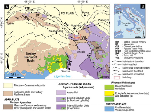
Figure 1. Regional structural sketch map (a) of the northwestern part of Northern Apennines and Ligurian Western Alps (modified from CitationBalestro, Festa, Dilek, & Tartarotti, Citation2015). (b) Location of (a) (modified from CitationVezzani, Festa, & Ghisetti, Citation2010).
On the basis of a new geological mapping at the 1:5000 scale, detailed structural and stratigraphic observations, and targeted collection of biostratigraphic data, we present the ‘Geological map of the Curone and Staffora Valleys (Northern Apennines, Italy)' (see Main Map) at the 1:20,000 scale. This Geological Map represents the northern prolongation of the ‘Geological Map of the Villalvernia – Varzi Line between Scrivia and Curone valleys (NW Italy)' by CitationFesta, Fioraso, Bissacca, and Petrizzo (Citation2015).
2. Methods
The geological map was produced from about four years (2014–2017) of fieldwork at the 1:5000 scale and accompanying detailed structural analyses and stratigraphic observations. The definition of the structural setting of the sector was defined through the mapping of the crosscutting relationships between main faults and local to regional stratigraphic unconformities that are documented in the attached geological map at the 1:20,000 scale (see Main Map), using the topographic maps ‘CTR – Carta Tecnica Regionale' of Regione Piemonte and Regione Lombardia. The distinction among different types of chaotic rock units (i.e. olistostromes and broken formations) followed specific criteria defined in literature (e.g. CitationBettelli & Panini, Citation1989; CitationBettelli, Conti, Panini, & Vannucchi, Citation2006; CitationDilek, Festa, Ogawa, & Pini, Citation2012; CitationFesta, Dilek, Codegone, Cavagna, & Pini, Citation2013; CitationFesta, Ogata, Pini, Dilek, & Alonso, Citation2016; CitationFesta, Pini, Dilek, & Codegone, Citation2010; CitationPini, Citation1999). The geological map was edited using the methodological cartographic and representative criteria from the CARG Project (Project of Geological Cartography) of Italy, at the 1:50,000 scale (see CitationPasquaré, Abbate, Bosi, et al., 1992; CitationPasquaré, Abbate, Castiglioni, et al., 1992).
3. Regional setting
The Northern Apennines () record the complex evolution from Late Cretaceous subduction to Cenozoic continental collision between the European plate and Adria microplate and subsequent intra-continental deformation (e.g. CitationCoward & Dietrich, Citation1989; CitationElter, Grasso, Parotto, & Vezzani, Citation2003; CitationFesta, Pini, Dilek, Codegone, Vezzani, et al., Citation2010; CitationHandy, Schmid, Bousquet, Kissling, & Bernoulli, Citation2010; CitationMarroni, Meneghini, & Pandolfi, Citation2010; CitationMolli, Crispini, Mosca, Piana, & Federico, Citation2010). The Late Cretaceous – Early Eocene accretionary stage has been recorded in the complex evolution of the Ligurian accretionary complex, which consists of different units containing tectono-sedimentary assemblages originally deposited in an ocean basin (i.e. Jurassic ophiolites and sedimentary cover of the Internal Ligurian Units), ocean-continental transition zone (External Ligurian Units), and thinned continental crust of the Adria margin (Subligurian Units), respectively. During the Late Cretaceous through Middle Eocene, these different units were deformed and incorporated into the Alpine accretionary wedge, formed as consequence of the east-dipping ‘Alpine’ subduction (i.e. CitationElter, Citation1975; CitationMarroni et al., Citation2010; CitationMarroni, Molli, Ottria, & Pandolfi, Citation2001; CitationPrincipi & Treves, Citation1984). Since the Middle Eocene, the thinned continental margin of Adria was involved in the W-dipping Apennine subduction (e.g. CitationCastellarin, Citation1994; CitationHandy et al., Citation2010; CitationMarroni et al., Citation2010; CitationMolli et al., Citation2010; CitationSchmid, Kissling, Diehl, van Hinsbergen, & Molli, Citation2017; CitationVezzani et al., Citation2010). The External Ligurian Units underthrust below the Internal Ligurian Units and together overlie the Subligurian Units, ultimately forming the frontal part of the advancing Ligurian accretionary complex, which, in turn, overthrust the deformed Adria continental margin. During the progressive incorporation into the accretionary wedge, a consistent part of the External Ligurian Units (i.e. the Lower to Upper Cretaceous ‘Basal Complex’) was strongly deformed by tectonic processes forming broken formations and tectonic mélanges (e.g. CitationBettelli & Panini, Citation1989; CitationCodegone, Festa, Dilek, & Pini, Citation2012; CitationFesta et al., Citation2013; CitationFesta, Pini, Dilek, Codegone, Vezzani, et al., Citation2010; CitationPini, Citation1999; CitationRemitti et al., Citation2011). Since the Middle – Late Eocene, different episutural and wedge-top basins (i.e. Tertiary Piedmont Basin and Epiligurian Units, respectively) unconformably covered the Ligurian accretionary complex () and the N- to NE-verging thrust-related structures (e.g. CitationMosca, Polino, Rogledi, & Rossi, Citation2010; CitationMutti et al., Citation1995; CitationRicci Lucchi, Citation1986).
Different mass-transport deposits, including olistostromes (i.e. sedimentary mélanges), occur at different stratigraphic levels within both the External Ligurian Units and Epiligurian Units, representing excellent markers of tectonic events (e.g. CitationFesta et al., Citation2016; see also CitationBettelli & Panini, Citation1989; CitationCodegone et al., Citation2012; CitationFesta et al., Citation2013; CitationFesta, Fioraso, et al., 2015; CitationOgata, Mountjoy, Pini, Festa, & Tinterri, Citation2014; CitationPiazza, Artoni, & Ogata, Citation2016; CitationPini, Citation1999; CitationRemitti et al., Citation2011).
4. Data
The study sector (), which is located between Curone and Staffora Valleys, is characterized by complex tectono-stratigraphic relationships between two different units of the External Ligurian Succession, represented by the Groppallo Unit (e.g. CitationVercesi et al., Citation2015) and the Cassio Unit (e.g. CitationElter, Elter, Sturani, & Weidmann, Citation1966; CitationVescovi, Fornaciari, Rio, & Valloni, Citation1999). These units are unconformably overlain by the Middle Eocene – Miocene Epiligurian Succession. To the north, this complex tectono-stratigraphic setting is sealed by the late Messinian – Early Pliocene succession.
4.1. Stratigraphy
4.1.1. External Ligurian Units
The stratigraphic succession (Chronostratigraphic Scheme in Main Map) of the Cassio Unit shows a complete transition from the ‘Basal Complex' (Scabiazza Sandstone and Argille Varicolori) to the late Maastrichtian – Late Palocene Viano Clays. The Scabiazza Sandstone (SCB in the Main Map, late Albian– Santonian) consists of a strongly disrupted chaotic succession (broken formation sensu CitationHsü, Citation1968) with bed fragments of whitish micaceous sandstones, embedded into a pelitic- to argillaceous matrix ((a,b)). The analysis of calcareous nannofossils shows mixing of late Albian, Aptian-Albian, Early Cretaceous and Early Jurassic taxa, and few taxa younger than Coniacian. The Argille Varicolori (AVV in the Main Map, Varicolored scaly clays; Santonian – Campanian; (c)) also represent a highly disrupted broken formation with blocks (limestones, sandstones, and manganiferous siltstones), deriving from stratal disruption of the primary lithostratigraphic unit, embedded in a varicolored (gray, red, and purple) clays and shales matrix. Tens of meters thick body of Salti del Diavolo Conglomerate (AVV1 in the Main Map, (d)), with clasts consisting of prevailing carbonate rocks and minor micaschist, gneiss, quartzite, granulite, pinkish granite and diorite, are interbedded within the Argille Varicolori. The latter are overlain by the late Campanian Monte Cassio Flysch (MCS in the Main Map, (e)), which consists of alternating beds of clayey marls and carbonate-rich calcareous-marly turbidites, dm to m thick. The Viano Clay (AVI in the Main Map, late Maastrichtian – Late Paleocene), consisting of alternating layers of claystones and less abundant limestones in dm thick beds, closes upward the stratigraphic succession of the Cassio Unit.
Figure 2. Field occurrence of the External Ligurian Succession (a– e: Cassio Unit; f–h: Groppallo Unit): (a) strongly disrupted chaotic succession (broken formation) of the Scabiazza Sandstone, showing a preferred alignment (i.e. pseudo-bedding) of sandstone bed fragments (west of Ca de’ Franchini); (b) close-up view of the Scabiazza Sandstone with bed fragments of whitish micaceous sandstone embedded into a pelitic-to argillaceous matrix; (c) noncylindrical and asymmetrical folds deforming alternating grey and reddish to purplish shale and minor black manganiferous siltstones in the Argille Varicolori (east of San Lorenzo). Hammer for scale; (d) close-up of the Salti del Diavolo Conglomerate (Cascina Sighera). Hammer for scale; (e) alternating bed of calcareous turbidites and grey marls of the Monte Cassio Flysch (Barca); (f) panoramic view of a serpentinite block, hundreds of m wide, embedded in the poorly outcropping argillaceous matrix of the Pietra Parcellara Complex (east of Zebedassi); (g,h) clast-supported debris flow of polymictic rounded to angular clasts of ultrabasic rocks (dark green to reddish in color) and oceanic cover succession (whitish in color) of the Pietra Parcellara Complex (north of Zebedassi). Hammer for scale in (g).
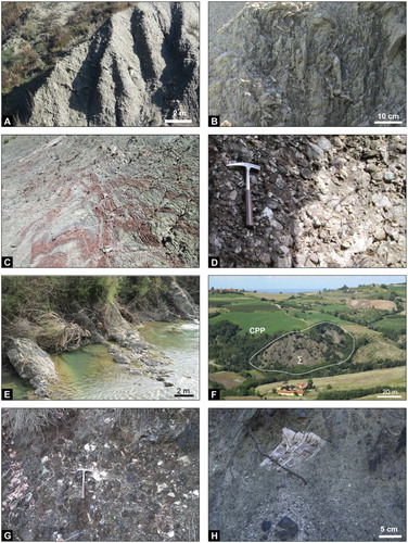
The Groppallo Unit consists of a chaotic complex with a block-in-matrix fabric (the Pietra Parcellara Complex – CPP in the Main Map), up to 150 m (or more) in thickness, in which heterogeneous blocks, up to hundreds of m in size ((f)), are randomly distributed in a matrix of coarse-grained ophiolitic sandstones ((g,h)) and polymictic argillaceous breccias. Huge blocks (olistoliths) are represented by mantle ultramafic rocks (i.e. spinel-lherzolites) locally intruded by small gabbro bodies, while clasts consist of lherzolites, gabbros, bed fragments of Calpionella Limestone and Palombini Shale, minor basalts, cherts (i.e. Radiolarites) and granitoids. It is worth noting that, although the nature of blocks and clasts of this Unit closely resemble that one of the Casanova Complex Auct. (sensu CitationBertotti, Elter, Marroni, Meccheri, & Santi, Citation1986; CitationElter, Marroni, Molli, & Pandolfi, Citation1991; CitationMarroni et al., Citation2001) rather than the classical one described for the Pietra Parcellara Complex (see, e.g. CitationMarroni et al., Citation2010; CitationVercesi et al., Citation2015), we prefer to maintain this last formational name because its structural position is well consistent with that of the Gropallo Unit described in the Northern Apennines (e.g. CitationVercesi et al., Citation2005; Citation2015). Analyses of calcareous nannofossils show an early Campanian age (CC18 zone of CitationSissingh, Citation1977) for the uppermost part of this chaotic complex.
4.1.2. Epiligurian Succession
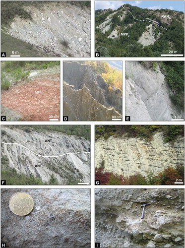
The Epiligurian Succession starts with the Baiso Argillaceous Breccias (BAI in the Main Map, Lutetian – Bartonian) ((a)), which consist of a lenticular and laterally discontinuous mass-transport chaotic deposit (olistostrome) sourced from the downslope dismemberment of the ‘Basal Complex’ and Monte Cassio Flysch. They pass upward (and local laterally) to hemipelagic clays and marls of the Monte Piano Marls (MMP in the Main Map, Lutetian – Priabonian) ((b,c)), which are overlain through an erosive unconformity surface ((b)) by turbidites of the Ranzano Formation. The latter, which is locally deposited directly above the External Ligurian Succession, is subdivided in three superimposed members (Pizzo d’Oca Member – RAN1 in the Main Map – of late Priabonian age, Val Pessola Member – RAN2 – of late Priabonian – early Rupelian age, and Varano de’ Melegari Member – RAN3 – of middle – late Rupelian age; (b), (d), and (e)), which differ for the stratigraphic position and petrographic composition of lithic fragments (see, e.g. CitationCibin, Di Giulio, & Martelli, Citation2003; CitationMartelli, Cibin, Di Giulio, & Catanzariti, Citation1998; CitationMutti et al., Citation1995). The succession continued, through an unconformity surface, with the slope fine-grained hemipelagic deposits of the Antognola Formation (ANT and ANT1a in the Main Map, late Rupelian – Aquitanian), which includes olistostromal lenticular bodies, up to 60 m thick, of the Val Tiepido–Canossa Argillaceous Breccias (ANT1b in the Main Map, i.e. ‘Complesso caotico pluriformazionale’ of CitationGelati, Bruzzi, Catasta, & Cattaneo, Citation1974; (f)) of Late Chattian age (planktonic foraminiferal zone IFP22 (P22) of CitationMancin, Pirini, Bicchi, Ferrero, & Valleri, Citation2003; see CitationFesta, Ogata, Pini, Dilek, & Codegone, Citation2015). Blocks embedded within the olistostrome are sourced from both the External Ligurian Succession and Epiligurian Succession (Monte Piano Marls and Ranzano Formation). The siliceous marls of Contignaco Formation (CTG in the Main Map, late Aquitanian – Burdigalian; see (g)) drape both the Ranzano Formation and Antognola Formation. The stratigraphic contact with Ranzano Formation (Colletta sector) corresponds to an angular unconformity, which passes laterally to a correlative conformity (Case Cucchi sector) where the Contignaco Formation overlies the Antognola Formation. In the latter sector, locally, the lower part of the Contignaco Formation is characterized by slumping structures. The Monte Lisone Chaotic Complex (CML in the Main Map, Late Burdigalian – Langhian?), which represents another mass-transport chaotic deposit (olistostrome), rests unconformably on both the uppermost part of the External Ligurian Succession and the Antognola Formation. It differs from the above described olistrostromes on the basis of the nature of blocks, consisting of only disrupted bed fragments of Helminthoides Flysch, and to the South of the studied sector it is overlain by the Monte Vallassa Sandstone (see CitationFesta, Fioraso, et al., 2015 for major details). The Epiligurian Succession continues through a regional unconformity with the shallow and coarse shelf deposits of the Monte Vallassa Sandstone (AMV in the Main Map, CitationGelati & Vercesi, Citation1994) of the Bismantova Group, Langhian – Serravallian in age ((h)). In the northern sector of the studied area, late Messinian (post-evaporitic) chaotic deposits (i.e. Valle Versa Chaotic Complex – CTV in the Main Map – sensu CitationDela Pierre et al., Citation2003) and the Cassano Spinola Conglomerates (CCS in the Main Map; (i)), which are followed by shelf deposits of Argille Azzurre (FAA in the Main Map; Piacenzian) and Asti Sandstone (AST in the Main Map; Zanclean), unconformably overlie both the External Ligurian Succession and the Epiligurian Succession.
Figure 3. Field occurrence of the Epiligurian Succession (a–h) and Messinian-Pliocene Succession (I): (a) panoramic view of the Baiso Argillaceous Breccias, showing the typical block-in-matrix fabric characterized by the random distribution of polymictic blocks sourced from the ‘Basal Complex’ and Helminthoides Flysch in argillaceous matrix (east of Cascina Galuzia); (b) panoramic view of the unconformable contact between the Monte Piano Marls (MPP2) and conglomerates and turbidite sandstone of Varano de’ Melegari Member (RAN3; Ranzano Formation) (near Giarella); (c) alternating whitish and reddish clayey marl of the Monte Piano Marls (MMP1, East of Cascina Galuzia); (d) grey to greenish coarse grain turbiditic sandstone and matrix-supported conglomerates of the Val Pessola Member (RAN2a, Ranzano Formation) (near Piumesana). Note that the attitude of bedding is subvertical; (e) thick bed (up to 2 m) of grey sandstone, interbedded within alternating greyish pelite and arenite, in dm thick beds, of the Varano de’ Melegari Member (RAN3, Ranzano Formation) (South of Giarella); (f) panoramic view of the contact between clayey marl of the Antognola Formation (ANT) and the Val Tiepido – Canossa Argillaceous Breccias (ANT1b) (close to Moglia). The latter are characterized by the random distribution of blocks, sourced from the ‘Basal Complex’ of the External Ligurian Succession and the Epiligurian Succession, within a clayey matrix, according to mass-transport processes of formation; (g) well-bedded whitish calcareous marls of the Contignaco Formation (east of Piumesana); (h) close-up of the bioclastic sandstone of the Monte Vallassa Sandstone (Serra del Monte), showing fragments of bivalve (coin for scale); (i) detail of the matrix-supported conglomerates and sandstones of the Cassano Spinola Conglomerate (close to Guagnina).
4.2. Tectonic setting
The tectonic setting is characterized by the ENE-trending of tectonic structures (thrusts, strike-slip faults, and regional scale folds), which are rotated to WNW-trending to the West of Curone Valley, being displaced by WNW- to NW-striking strike-slip faults (see Main Map and related Structural scheme).
In the north-central part of the studied sector, the Barca-Sala Thrust (BST hereafter), ENE-striking and SSE dipping, superposes the Cassio Unit and Epiligurian Succession onto a composite tectonic unit, characterized by the tectonic relationships among the Cassio Unit, the Middle Eocene to Burdigalian part of the Epiligurian Succession, and the Groppallo Unit (see cross sections 3 and 4 in Main Map). The BST, which is splitted into two main sub-parallel surfaces bounding an elongated slice of Argille Varicolori, shows a gradual decrease of offset toward WSW where it is truncated by a NW-striking fault located along the Curone Valley. The hanging wall of the BST is deformed by E- to ENE-trending open folds, which involve the Epiligurian Succession up to the Monte Vallassa Sandstone. Here, the Cassio Unit depicts a roughly SE-dipping monocline, with local open folds with NE-to ENE-striking fold axis. Two main fault systems (ENE- and N-directed) dissect the hanging wall succession. The ENE-striking faults mainly define a deformation zone (Momperone – Vignola Deformation Zone – MVDZ hereafter), several km long and hundreds of m wide, formed by the interlacing of E- and ENE-striking fault segments. In detail, the latters show transpressive left- and right-lateral movements, respectively ((a)). In the Colletta sector, the MVDZ is unconformable sealed by the Contignaco Formation and, to the south (Vignola sector), by the Monte Vallassa Sandstone (see cross section 3 in Main Map, (b)). The N-striking faults show normal kinematics, as outlined by cartographic evidences such as the displacement of stratigraphic contacts among different members of the Monte Piano Marls and the Ranzano Formation (see Main Map). Particularly, the Val Pessola Member and Varano de’ Melegari Member show E-W directed change of thickness in sector bounded by those faults (see cross section 1 in Main Map). Left-lateral reactivations of this fault system are documented by slickenlines on fault surfaces ((a)).
Figure 4. (a) Diagrams showing mesoscale data (Schmidt net, lower hemisphere) of main fault systems and fold axes described in the text. Right- and left-lateral fault kinematics are indicated with red and black colors, respectively; (b) panoramic view and schematic sketch of the Vignola sector, showing the unconformable overlain of the Monte Vallassa Sandstone (Langhian – Serravallian, AMV) onto the ENE-striking Momperone – Vignola Deformation Zone (MVDZ, red lines), which tectonically juxtaposes the Antognola Formation (late Rupelian – Aquitanian, ANT) and the Val Tiepido Canossa Polygenetic Argillaceous Breccias (ANT1b). In the sketch, dark and shadow colors indicate outcrops and interpreted areas, respectively; (c) panoramic view of the San Desiderio Deformation Zone (red lines) close to Monticelli, displacing and juxtaposing with transpressive right-lateral displacement the Cassio Unit (Argille Varicolori – AVV, Late Cretaceous), different terms of the Epiligurian Succession (Monte Piano Marls, MMP1, Middle – Late Eocene, and the Varano de’ Melegari Member of the Ranzano Formation – RAN3, middle – late Ruperlian), the Cassano Spinola Conglomerate (late Messinian), and Argille Azzurre (Early Pliocene); (d) detail of the San Desiderio Deformation Zone (SDDZ), showing the tectonic contact between the Baiso Argillaceous Breccias (BAI), the Monte Piano Marls (MMP1), and the Argille Varicolori (AVC) along a transpressive right-lateral faults (red lines), ENE-striking (east of Cascina Galuzia). S-C shears are indicated by dotted white line; (e) isoclinal and transposed folds with fold axes displaying WNW- and ESE-oriented maxima in the Argille Varicolori (close to Cascina Galuzia), showing stretching and thinning of the limbs; (f) block-in-matrix fabric in the Argille Varicolori, showing the alignment of elongated blocks (i.e. pseudo-bedding) and the scaly fabric of the shaly matrix (South of Guagnina).
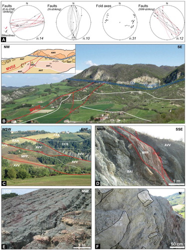
In the footwall of the BST, the Groppallo Unit defines a tectonic window overthrust by the Cassio Unit along a thrust folded by a NW-striking, open to gentle anticline, with SE-fold axis plunge (see Main Map). The thrust dips to NE and SW in the northeastern and southwestern sides of the tectonic window, respectively, superposing the Scabiazza Sandstone (northestern side), the Monte Cassio Flysch and the Scabiazza Sandstone (southwestern side) onto the Pietra Parcellara Complex (see cross section 2 in Main Map). Along the northeastern side of the tectonic window, the Scabiazza Sandstone is locally involved by thrust splays and imbricated with the Pietra Parcellara Complex, forming lenticular tectonic slices, hundreds of m in length. To ENE, the footwall of the BST is characterized by a hundreds of meters wide and 5 km long deformation zone (San Desiderio Deformation Zone – SDDZ hereafter), which is about WNW-ESE and ENE-WSW oriented to the West and East sectors of the Staffora Valley, respectively ((c)). Mesoscale structural associations (S–C shears; (d)) and fault striations (slikenlines) show transpressive right-lateral movements, according to the cartographic displacement of stratigraphic contacts observed in the Map. This deformation zone juxtaposes the Monte Cassio Flysch and the Argille Varicolori to different terms of the Epiligurian Succession (i.e. Baiso Argillaceous Breccias, Monte Piano Marls and Ranzano Formation; see cross sections 2, 3 and 4 in Main Map; (c)). Far from faults bounding the SDDZ, the Argille Varicolori preserve an earlier layer-parallel extensional block-in-matrix fabric, which is deformed by rootless and transposed folds ((e,f)). The latters are characterized by curviplanar axial surfaces, with fold axes displaying a broad girdle with WNW- and ESE-oriented maxima ((a,e)), and asymmetrical boudinaged limbs by R and C’ shears along NE-SW cross sections, commonly displaced by localized shear zones.
The tectonic setting above described is cut by two main fault systems, NW- and N-striking. The former corresponds to pluri-km long faults, which cut with left-lateral movements, reactivated by right-lateral ones as shown by fault striations (slickenlines) on fault surfaces ((a)) and S–C shears, both the BST and the SDDZ (see Main Map). From East to West of the NW-striking fault of the Curone Valley, the main fold axes, bedding surfaces, and stratigraphic boundaries are gradually rotated from ENE-WSW to WNW-ESE directions and cut by NE-striking faults to the West of that Valley (see Main Map).
The N-striking fault system shows best exposures only in the northeaster sector of the studied area (East of Mt. Treno), representing the southern prolongation of the Pliocene Schizzola Valley Fault of CitationPerotti and Vercesi (Citation1991) and CitationVercesi et al. (Citation2015). The latter defines a hundreds of meters wide deformation zone, with left-lateral kinematics (e.g. CitationVercesi et al., Citation2015), bounded by interlaced subvertical faults with anastomosed geometry.
5. Conclusions
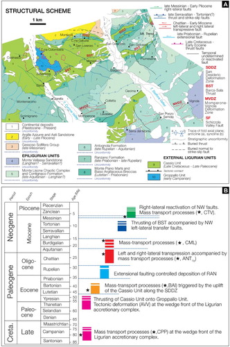
The crosscutting relationships between mapped faults and stratigraphic unconformities, and the distinction of different types of chaotic rock unit, allow describing a detailed tectono-stratigraphic evolution of this sector of the Northern Apennines. Six main tectonic stages have been defined from Late Cretaceous to Pliocene ((a,b)).
Late Cretaceous – Early Eocene: this tectonic stage preserves the record of both gravitational (i.e. olistostrome) and tectonic-induced (i.e. broken formation) deformation related to the evolution at shallow structural levels of the External Ligurian wedge during the subduction stage. The random distribution of polymictic blocks within the matrix of the Pietra Parcellara Complex (Groppallo Unit) is consistent with mass-transport processes occurred at the wedge front during Campanian time ((b), Eoalpine Phase of CitationElter et al., Citation1966; see also, CitationBertotti et al., Citation1986; CitationElter et al., Citation1991). On the contrary, far from the main faults of the SDDZ, the orientation and distribution of fold axes (with WNW- and ESE-oriented maxima) within the Argille Varicolori is consistent with the tectonic deformation related to NE-SW to NNE-SSW shortening directions, which are commonly attributed (e.g. CitationCerrina Feroni, Ottria, Martinelli, & Martelli, Citation2002; CitationElter & Marroni, Citation1991; CitationLevi, Ellero, Ottria, & Pandolfi, Citation2006) to the Paleocene – Early Eocene European verging overthrust ((b)) of the Helminthoides Flysch nappe onto the ‘Basal Complex’. The characteristics of mesoscale deformation within the Argille Varicolori (see ‘Tectonic setting’) well agree with deformation occurred in the frontal and shallower levels of the External Ligurian wedge, affecting unconsolidated sediments in the latest stages of accretion (e.g. CitationBettelli & Vannucchi, Citation2003; CitationFesta et al., Citation2013; CitationFesta & Codegone, Citation2013; CitationPini, Citation1999). Although the time for tectonic superposition of the Cassio Unit onto the Groppallo Unit is difficult to constrain because of the lack of a detailed stratigraphic marker, the lack of involvement of Epiligurian Succession suggests it occurred earlier than Middle Eocene time ((a,b)). Regarding the Cassio Unit, it is worth noting that the age of the Scabiazza Sandstone (late Albian – Santonian) is similar to that one observed in the Media Val Taro Unit (see, CitationVescovi et al., Citation2002; see also Ostia Sandstone of CitationVescovi et al., Citation1999) and in the Cabella Ligure sector (see, CitationMarroni, Ottria, & Pandolfi, Citation2015), and younger than that one commonly described for the classical Cassio Unit (i.e. Cenomanian – Turonian). Although additional investigations are needed, these data suggest the deposition of this Formation in an outer sector of the Cassio basin (with respect to the West-verging ‘Alpine’ accretionary wedge), providing new constraints for a more detailed reconstruction of the internal physiography of the depositional environment of the External Ligurian Succession.
Middle Eocene (Lutetian – Bartonian): the wide occurrence of the Baiso Argillaceous Breccias along the SDDZ, ENE- to WNW-oriented, and their increase in thickness away from it, suggest that this deformation zone was active at least since Middle Eocene ((a,b)), favoring mass-transport processes triggered by the tectonic uplift of the ‘Basal Complex’ and Monte Cassio Flysch. Unfortunately, a detailed description of Middle Eocene kinematics of the SDDZ is hampered by late Messinian – Early Pliocene right-lateral reactivations of main faults (see below ‘Late Messinian – Early Pliocene’ stage). This mass-transport event marks an important stage of the regional scale instability of the External Ligurian wedge (e.g. CitationBettelli & Panini, Citation1989), which can be related to the early stage of continental collision (Mesoalpine stage or Ligurian Phase, e.g. CitationCerrina Feroni, Ottria, & Ellero, Citation2004; CitationElter, Citation1975; CitationMarroni et al., Citation2010; CitationMutti et al., Citation1995). The uppermost temporal constrain to this tectonic stage is represented by the unconformable deposition of the Ranzano Formation (Late Eocene – Early Oligocene) onto both the Baiso Argillaceous Breccias and External Ligurian Succession ((a,b)).
Late Priabonian – Rupelian: the NE-and N-striking normal faults, which displace the lower portion of the Epiligurian Succession, controlled the physiography of Late Eocene – Early Oligocene depositional basin as suggested by both the E-W change in thickness of the Val Pessola Mb. and Varano de’ Melegari Mb. of the Ranzano Formation (see cross section 1 in Main Map, (a)). At the regional scale, this stage is close associated with faulting along the Villalvernia – Varzi Line, which controlled the depositional settings of both the Tertiary Piedmont Basin and Epiligurian Succession (e.g. CitationDi Biase, Marroni, & Pandolfi, Citation1997; CitationDi Giulio & Galbiati, Citation1995; CitationFelletti, Citation2002; CitationFesta, Fioraso, et al., 2015; CitationMarroni et al., Citation2002; CitationMutti et al., Citation1995), and corresponds to the Ligurian phase II of CitationMutti et al. (Citation1995) and Faulting stage A of CitationPiana (Citation2000) and CitationFesta et al. (Citation2005, Citation2013), CitationFesta, Fioraso, et al. (2015), which are related to the opening of the Balearic Sea. The deposition of the Antognola Formation (late Rupelian – Aquitanian), which unconformably overlains different terms of the Ranzano Formation and External Ligurian Succession, provides the temporal constrain for this tectonic stage ((a,b)).
Chattian – Early Miocene: the former extensional regime was inverted to a compressional one that accompanied the deposition of the Antognola Formation. This stage is mostly recorded along the MVDZ, developed by the interlacing of ENE-striking transpressive right-lateral faults and E-striking transpressive left-lateral ones, and the widespread occurrence of olistostromes of the Val Tiepido – Canossa Argillaceous Breccias, which sourced from denudation of uplifted External Ligurian Succession and the lower part of Epiligurian Succession. In the southwestern sector of the study area, submarine structural highs formed during the Middle Eocene – Rupelian stage were sealed by the unconformable deposition of the Contignaco Formation (Colletta sector; see cross section 3, (a,b)). Toward east (e.g. Case Cucchi sector), the occurrence of slumping in the lower part of the Contignaco Formation marks the paleo-scarp connecting the structural highs with a seafloor basinal low, where the unconformity surface at the base of the Contignaco Formation passes gradually to a correlative conformity. A second pulse of gravitational instability occurred in the Burdigalian – Langhian(?) as suggested by the mass-transport emplacement of the Monte Lisone Chaotic Complex. This tectonic stage was definitively sealed by the Monte Vallassa Sandstone, which unconformably overlain faults associated with the MVDZ ((a,b)). At the regional scale, this stage is related to the migration toward NE of the Apenninic thrust front (Ligurian Phase III of CitationMutti et al., Citation1995; Faulting Stage B of CitationFesta et al., Citation2005, Citation2013; CitationPiana, Citation2000; see also CitationPiazza et al., Citation2016).
Late Serravallian – Tortonian(?): The NNW-verging migration of BST, ENE-striking, and the deformation of the Epiligurian Succession with ENE-directed fold axis, well agree with this tectonic stage. The left-lateral NW-striking faults, which displace the lateral continuity of the BST, probably worked as transfer faults ((a,b)) as documented to the south of the study area for the left-lateral Sarizzola Fault Zone, NW-striking, which cuts the Villalvernia – Varzi Fault Zone (see CitationFesta, Fioraso, et al., 2015). At the regional scale, this tectonic stage is related to the northwestward propagation of Apenninic thrust system (e.g. CitationFesta et al., Citation2005; CitationMosca et al., Citation2010; CitationPiana, Citation2000), during which left-lateral NW-faults represented transfer faults (CitationCosta, Citation2003). Although only minor evidences are preserved in the mapped area, the uppermost temporal constrain to this tectonic stage is represented by the unconformity at the base of the late Messinian Valle Versa Chaotic Complex immediately to the south ((b); e.g. CitationFesta, Fioraso, et al., 2015 and reference therein.
Late Messinian – Early Pliocene: tectonic deformation triggered the mass-transport emplacement of the Valle Versa Chaotic Complex. NW-striking transtensional faults cut both the SDDZ and the BST ((a,b)). At the northern boundary of the SDDZ, this caused the juxtaposition of the Argille Varicolori to the late Messinian – Early Pliocene succession, while across the Curone Valley it separates sectors characterized by a gradual reorientation of both the late Priabonian – Rupelian faults (from N- to NE-striking; (a)) and the main fold axes (from ENE- to NW-striking; (a)). This reorientation suggests a refolding of earliest main tectonic features, during which the NW-striking fault of the Curone Valley acted as transfer fault, accommodating part of this deformation ((a)). To the West of the Curone Valley, the displacement of fold axial plane along NE-striking faults also suggests the reactivation of those faults, which controlled the deposition of the Ranzano Formation during the late Priabonian – Rupelian stage. At the regional scale, this stage is related to the N-S shortening that caused a further northward migration of the Apenninic frontal thrust (Faulting Stage D of CitationFesta et al., Citation2005; see also CitationArtoni et al., Citation2010; CitationFesta, Citation2011; CitationMosca et al., Citation2010). Finally, the N-striking Schizzola valley fault, which cuts the SDDZ, probably represents a fault system younger than Early Pliocene as suggested by CitationPerotti and Vercesi (Citation1991) and CitationVercesi et al. (Citation2015).
Figure 5. (a) Structural scheme of the studied sector, showing the crosscutting relationships between different faulting stages (indicated with different colors) and stratigraphic unconformities (see text for complete explanation). (b) These relationships allow to define six tectonic stages as summarized in the time column (see Legend of the Main Map for acronyms). Main mass-transport deposits and main unconformities surfaces are evidenced (black asterisk and dotted blue line, respectively).
Software
The geological map and map inclusions were digitized and edited with Adobe Illustrator CC.
Barbero_et_al_MAIN_MAP_JOM_R1.pdf
Download PDF (15.6 MB)Acknowledgements
We thank G. Balestro, S. De Caroli, G. Codegone, L. Papani and A. Succo for passionate discussions on the geology of the studied sector, and we would like to express our sincere thanks to H. Apps, A. Artoni, and L. Pandolfi for their constructive and thorough reviews and useful comments, from which we have benefited greatly in revising both our manuscript and geological map.
Disclosure statement
No potential conflict of interest was reported by the authors.
Additional information
Funding
Related Research Data
References
- Artoni, A., Bernini, M., Papani, G., Rizzini, F., Barbacini, G., Rossi, M., … Ghielmi, M. (2010). Mass-transport deposits in confined wedge-top basins: Surficial processes shaping the messinian orogenic wedge of Northern Apennine of Italy. Italian Journal of Geosciences, 129, 101–118.
- Balestro, G., Festa, A., Dilek, Y., & Tartarotti, P. (2015). Pre-Alpine extensional tectonics of a peridotite-localized oceanic core complex in the late Jurassic, high-pressure Monviso ophiolite (Western Alps). Episodes, 38, 266–282. doi: 10.18814/epiiugs/2015/v38i4/82421
- Bellinzona, G., Boni, A., Braga, G., & Marchetti, G. (1971). Note illustrative della Carta Geologica d’Italia alla scala 1:100.000, Foglio Voghera 71. Servizio Geologico d’Italia, 1–121.
- Bertotti, G., Elter, P., Marroni, M., Meccheri, M., & Santi, R. (1986). Le Argilliti a blocchi di Monte Veri: considerazioni sull’evoluzione tettonica del bacino Ligure nel Cretaceo superiore. Ofioliti, 11, 193–220.
- Bettelli, G., Conti, S., Panini, F., & Vannucchi, P. (2006). The mapping of chaotic rocks in Abruzzo (Central Italy): comparison with selected examples from Northern Apennines. In G. Pasquaré & C. Venturini (Eds.), Mapping geology in Italy (pp. 199–206). Firenze: S.EL.CA.
- Bettelli, G., & Panini, F. (1989). I mélanges dell’Appennino settentrionale tra il T. Tresinaro ed il T. Sillaro. Memorie Della Società Geologica Italiana, 39, 187–214.
- Bettelli, G., & Vannucchi, P. (2003). Structural style of the offscraped Ligurian oceanic sequences of the Northern Apennines: New hypothesis concerning the development of mélange block-in-matrix fabric. Journal of Structural Geology, 25, 371–388. doi: 10.1016/S0191-8141(02)00026-3
- Boccaletti, M., & Coli, M. (1982). Carta Strutturale dell’Appennino settentrionale. C.N:R:, Progetto Finalizzato geodinamica, Sottoprogetto 5 – Modello Strutturale, pubblicazione n.429. S.El.Ca. Firenze, scale 1:250,000 3 sheets.
- Boni, A. (1969). Carta Geologica d’Italia a scala 1:100,000. Foglio 71 Voghera. Servizio Geologico d’Italia, Stab L. Salomone, Roma.
- Castellarin, A. (1994). Strutturazione eo- e mesoaplina dell’Appennino Settentrionale attorno al nodo ligure. Studi Geologici Camerti, 2, 99–108.
- Catanzariti, R., Rio, D., & Martelli, L. (1997). Late Eocene to Oligocene calcareous nannofossil biostratigraphy in Northern Apennines: The Ranzano Sandstone. Memorie di Scienze Geologiche, 49, 207–253.
- Cerrina Feroni, A., Ottria, G., & Ellero, A. (2004). The Northern Apennine, Italy: Geological structure and transpressive evolution. Special Volume of the Italian Geological Society for the ICG 32 Florence. Geological Society of Italy, 15–32.
- Cerrina Feroni, A., Ottria, G., Martinelli, P., & Martelli, L. (2002). Carta geologico-strutturale dell’Appennino emiliano – romagnolo alla scala 1:250.000. Regione Emilia Romagna, C.N.R., Ed. S.EL.CA. Firenze.
- Cibin, U., Di Giulio, A., & Martelli, L. (2003). Oligocene-early Miocene tectonic evolution of the Northern Apennines (northwestern Italy) traced through provenance of piggy-back basin fill successions. Geolocial Society of London, Special Publications, 208, 269–287. doi: 10.1144/GSL.SP.2003.208.01.13
- Codegone, G., Festa, A., Dilek, Y., & Pini, G. A. (2012). Small-scale polygenetic mélanges in the Ligurian accretionary complex, Northern Apennines, Italy, and the role of shale diapirism in superposed mélange evolution in orogenic belts. Tectonophysics, 568–569, 170–184. doi: 10.1016/j.tecto.2012.02.003
- Costa, M. (2003). The buried Apenninic arcs of the Po Plain and Northern Adriatic Sea (Italy): A new model. Bollettino della Società Geologica Italiana, 122, 3–23.
- Coward, M. P., & Dietrich, D. (1989). Alpine tectonics – an overview. In M. P. Coward, D. Dietrich, & R. G. Park, (Eds.), Alpine tectonics (Vol. 45, pp. 1–29). London: Geological Society of London Special Publication.
- Dela Pierre, F., Piana, F., Fioraso, G., Boano, P., Bicchi, E., Forno, M. G., … Polino, R. (2003). Carta Geologica d’Italia alla scala 1:50.000. Foglio 157 ‘Trino’. ISPRA, Istituto Superiore per la Protezione e la Ricerca Ambientale, 1 sheet at 1:50,000 scale and illustrative notes.
- Di Biase, D., Marroni, M., & Pandolfi, L. (1997). Age of the deformation phases in the internal liguride units: Evidences from lower Oligocene Val Borbera conglomerate of Tertiary Piedmont Basin (Northern Italy). Ofioliti, 22, 231–238.
- Di Giulio, A., & Galbiati, B. (1995). Interaction between tectonics and deposition into an episutural basin in the Apls-Apennines knot. In R. Polino & R. Sacchi (Eds.), Atti del Convegno sul tema “Rapporti tra Alpi e Appennino” e guida alle escursioni (pp. 113–128). Roma: Accademia Nazionale delle Scienze detta dei XL, Scritti e Documenti.
- Dilek, Y., Festa, A., Ogawa, Y., & Pini, G. A. (2012). Chaos and geodynamics: Mélanges, mélange-forming processes and their significance in the geological record. Tectonophysics, 568–569, 1–6. https://doi.org/10.1016/j.tecto.2012.08.002
- Elter, P. (1975). L’Ensamble Ligure. Bullettin dé la Société Géologique de France, 17, 984–997. doi: 10.2113/gssgfbull.S7-XVII.6.984
- Elter, G., Elter, P., Sturani, P., & Weidmann, M. (1966). Sur la prolungation du domaine ligure de l’Apennin dans le Monferrat et les Alpes et sur l’origine de la Nappe de la Siemme s.l. des Prealpes romandes et chaiblaisiennes. Archives des Sciences, 176, 279–377.
- Elter, P., Grasso, M., Parotto, M., & Vezzani, L. (2003). Structural setting of the Apennine-Maghrebian thrust belt. Episodes: Journal of International Geosciences, 26, 205–211.
- Elter, P., & Marroni, M. (1991). Le Unità Liguri dell’Appennino Settentrionale: sintesi dei dati e nuove interpretazioni. Memorie Descrittive della Carta Geologica d’Italia, 46, 131–138.
- Elter, P., Marroni, M., Molli, G., & Pandolfi, L. (1991). Le caratteristiche stratigrafiche del Complesso di M. Penna/Casanova (Alta Val di Trebbia, Appennino Settentrionale). Atti Ticinensi di Scienze della Terra, 34, 97–106.
- Felletti, F. (2002). Complex bedding geometries and facies associations of the turbiditic fill of a confined basin in a transpressive setting (Castagnola FM, Tertiary Piedmont Basin NW Italy). Sedimentology, 49, 645–667. doi: 10.1046/j.1365-3091.2002.00467.x
- Festa, A. (2011). Tectonic, sedimentary, and diapiric formation of the Messinian melange: Tertiary Piedmont Basin (northwestern Italy). In J. Wakabayashi & Y. Dilek (Eds.), Melanges: Processes of formation and societal significance (vol. 480, pp. 215–232). Geological Society of America Special Paper. doi:10.1130/2011.2480(10)
- Festa, A., & Codegone, G. (2013). Geological map of the External Ligurian Units in western Monferrato (Tertiary Piedmont Basin, NW Italy). Journal of Maps, 9, 84–97, including a geological map at 1:10,000 scale. 1 sheet. doi: 10.1080/17445647.2012.757711
- Festa, A., Dilek, Y., Codegone, G., Cavagna, S., & Pini, G. A. (2013). Structural anatomy of the Ligurian accretionary wedge (Monferrato, NW Italy), and evolution of superposed mélanges. Geological Society of America Bulletin, 125(9–10), 1580–1598. doi: 10.1130/B30847.1
- Festa, A., Fioraso, G., Bissacca, E., & Petrizzo, M. R. (2015). Geology of the Villalvernia-Varzi Line between Scrivia and Curone valleys (NW Italy). Journal of Maps, 11, 39–55. doi: 10.1080/17445647.2014.959569
- Festa, A., Ogata, K., Pini, G. A., Dilek, Y., & Alonso, J. L. (2016). Origin and significance of olistostromes in the evolution of orogenic belts: A global synthesis. Gondwana Research, 39, 180–203. doi: 10.1016/j.gr.2016.08.002
- Festa, A., Ogata, K., Pini, G. A., Dilek, Y., & Codegone, G. (2015). Late Oligocene – early Miocene olistostromes (sedimentary mélanges) as tectono-stratigraphic constraints to the geodynamic evolution of the exhumed Ligurian accretionary complex (Northern Apennines, NW Italy). International Geology Review, 57, 540–562. doi: 10.1080/00206814.2014.931260
- Festa, A., Piana, F., Dela Pierre, F., Malusà, M. G., Mosca, P., & Polino, R. (2005). Oligocene-Neogene kinematic constraints in the retroforeland basin of the Northwestern Apls. Rendiconti della Società Geologica Italiana (nuova serie), 1, 107–108.
- Festa, A., Pini, G. A., Dilek, Y., & Codegone, G. (2010). Melanges and melange-forming processes: A historical overview and new concepts. In Y. Dilek (Ed.), Alpine Concept in Geology. International Geology Review, 52(10–12), 1040–1105. doi: 10.1080/00206810903557704
- Festa, A., Pini, G. A., Dilek, Y., Codegone, G., Vezzani, L., Ghisetti, F., Lucente, C. C., & Ogata, K. (2010). Peri-Adriatic mélanges and their evolution in the Thetyan realm. In Y. Dilek (Ed.), Eastern Mediterranean geodynamics (Part II). International Geology Review, 52(4–6), 369–406. doi: 10.1080/00206810902949886
- Fornaciari, E., & Rio, D. (1996). Latest Oligocene to early middle Miocene quantitative calcareous nannofossil biostratigraphy in the Mediterranean area. Micropaleontology, 42, 1–36. doi: 10.2307/1485981
- Gelati, R., Bruzzi, D., Catasta, G., & Cattaneo, P. C. (1974). Evoluzione stratigrafico – strutturale nell’Appennino vogherese a nord-est della Val Staffora. Rivista Italiana di Paleontologia e Stratigrafia, 80, 479–514.
- Gelati, R., & Vercesi, P. L. (1994). Itinerario N8 3. Da Voghera a Tortona (Km 120). Geologia delle Valli Staffora, Curone, Grue: le Successioni Epiliguri a nord della Linea Villalvernia – Varzi. Guide Geologiche Regionali S.G.I., N° 6, BE-MA Editrice, 157–174.
- Handy, M. R., Schmid, S. M., Bousquet, R., Kissling, E., & Bernoulli, D. (2010). Reconciling plate-tectonic reconstructions of Alpine Tethys with the geological–geophysical record of spreading and subduction in the Alps. Earth-Science Reviews, 102, 121–158. doi: 10.1016/j.earscirev.2010.06.002
- Hsü, K. J. (1968). Principles of mélanges and their bearing on the Franciscan-Knoxville paradox. Geological Society of America Bulletin, 79, 1063–1074. doi: 10.1130/0016-7606(1968)79[1063:POMATB]2.0.CO;2
- Levi, N., Ellero, A., Ottria, G., & Pandolfi, L. (2006). Polyorogenic deformation history recognized at very shallow structural levels: The case of the Antola Unit (Northern Apennines, Italy). Journal of Structural Geology, 28, 1694–1709. doi: 10.1016/j.jsg.2006.04.002
- Mancin, N., Pirini, C., Bicchi, E., Ferrero, E., & Valleri, G. (2003). Middle Eocene to Early Miocene planktonic foraminiferal biostratigraphy for internal basins (Monferrato and Northern Apennines, Italy). Micropaleontology, 49(4), 341–358. doi: 10.2113/49.4.341
- Marroni, M., Feroni, A. C., Di Biase, D., Ottria, G., Pandolfi, L., & Taini, A. (2002). Polyphase folding at upper structural levels in the Borbera Valley (Northern Apennines, Italy): Implications for the tectonic evolution of the linkage area between Alps and Apennines. Comptes Rendus Geoscience, 334, 565–572. doi: 10.1016/S1631-0713(02)01784-4
- Marroni, M., Meneghini, F., & Pandolfi, L. (2010). Anatomy of the Ligure-Piemontese subduction system: evidence from Late Cretaceous-middle Eocene convergent margin deposits in the Northern Appennines, Italy. International Geology Review, 52, 1160–1192. doi: 10.1080/00206810903545493
- Marroni, M., Molli, G., Ottria, G., & Pandolfi, L. (2001). Tectono-sedimentary evolution of the External Liguride units (Northern Apennines, Italy): Insights in the pre-collisional history of a fossil ocean-continent transition zone. Geodinamica Acta, 14, 307–320. doi: 10.1080/09853111.2001.11432449
- Marroni, M., Ottria, G., & Pandolfi, L. (2015). Carta Geologica d’Italia alla scala 1:50.000. Foglio 196 ‘Cabella Ligureʹ. ISPRA, Istituto Superiore per la Protezione e la Ricerca Ambientale, 1 sheet at 1:50,000 scale and illustrative notes.
- Marroni, M., & Pandolfi, L. (2007). The architecture of the Jurassic Ligure-Piemontese oceanic basin: Tentative reconstruction along the Northern Apennine-Alpine Corsica transect. International Journal of Earth Science, 96, 1059–1078. doi: 10.1007/s00531-006-0163-x
- Martelli, L., Cibin, U., Di Giulio, A., & Catanzariti, R. (1998). Litostratigrafia della Formazione di Ranzano (Priaboniano-Rupeliano, Appennino Settentrionale e Bacino Terziario Piemontese). Bollettino Della Società Geologica Italiana, 117, 151–185.
- Martini, E. (1971). Standard Tertiary and Quaternary calcareous nannoplankton zonation. In A. Farinacci (Ed.), Proceedings of the second planktonic conference, Roma 1970: Edizioni Tecnoscienza, 2, 739–785.
- Molli, G., Crispini, L., Mosca, P., Piana, P., & Federico, L. (2010). Geology of the Western Alps-Northern Apennine junction area: A regional review. Journal of the Virtual Explorer, 36, paper 10 of the electronic edition ISSN 1441-8142. doi: 10.3809/jvirtex.2010.00215
- Mosca, P., Polino, R., Rogledi, S., & Rossi, M. (2010). New data for the kinematic interpretation of the Alps-Apennines junction (northwestern Italy). International Journal of Earth Sciences, 99, 833–849. doi: 10.1007/s00531-009-0428-2
- Mutti, E., Papani, L., Di Biase, D., Davoli, G., Mora, S., Segadelli, S., & Tinterri, R. (1995). Il Bacino Terziario Epimesoalpino e le sue implicazioni sui rapporti tra Alpi ed Appennino. Memorie della Società Geologica di Padova, 47, 217–244.
- Ogata, K., Mountjoy, J.J., Pini, G.A., Festa, A., & Tinterri, E. (2014). Shear zone liquefaction in mass transport deposit emplacement: A multi-scale integration of seismic reflection and outcrop data. Marine Geology, 356(Special Issue), 50–64. doi: 10.1016/j.margeo.2014.05.001
- Pasquaré, G., Abbate, E., Bosi, C., Castiglioni, G. B., Merenda, L., Mutti, E., … Sassi, F. P. (1992). Carta Geologica d’Italia – 1:50.000. Guida al Rilevamento. Servizio Geologico Nazionale. Quaderni serie III. Vol. 1, 203 pp.
- Pasquaré, G., Abbate, E., Castiglioni, G. B., Merenda, L., Mutti, E., Ortolani, F., … Sassi, F. P. (1992). Guida al rilevamento e all’informatizzazione della Carta Geologica d’Italia alla scala 1:50,000. Quaderni del Servizio Geologico Nazionale, serie III, 1, 203.
- Perotti, C., & Vercesi, P. L. (1991). Assetto tettonico ed evoluzione strutturale recente della porzione nord-occidentale dell’Appennino emiliano. Memorie Descrittive della Carta Geologica d’Italia, 46, 313–326.
- Piana, F. (2000). Structural features of Western Monferrato (Alps-Apennines junction zone, NW Italy). Tectonics, 19, 943–960. doi: 10.1029/2000TC900013
- Piazza, A., Artoni, A., & Ogata, K. (2016). The Epiligurian wedge-top succession in the Enza Valley (Northern Apennines): Evidence of a syn-depositional transpressive system. Swiss Journal of Geosciences, 109, 17–36. doi: 10.1007/s00015-016-0211-x
- Pini, G. A. (1999). Tectonosomes and olistostromes in the Argille Scagliose of the Northern Apennines, Italy. Geological Society of America Special Papers 335, 73 pp.
- Principi, G., & Treves, B. (1984). Il sistema corso-appenninico come prisma d’accrezione. Riflessi sul problema generale del limite Alpi-Appennini. Memorie della Società Geologica Italiana, 28, 549–576.
- Remitti, F., Vannucchi, P., Bettelli, G., Fantoni, L., Panini, F., & Vescovi, P. (2011). Tectonic and sedimentary evolution of the frontal part of an ancient subduction complex at the transition from accretion to erosion: The case of the Ligurian wedge of the northern Apennines, Italy. Geological Society of America Bulletin, 123, 51–70. doi: 10.1130/B30065.1
- Ricci Lucchi, F. (1986). The Oligocene to recent foreland basin of the Northern Appennines. In P. A. Allen & P. Homewood (Eds.), Foreland basins (pp. 105–139). Freiburg: International Association of Sedimentologists Special Publication 8, Blackwell.
- Schmid, S. M., Kissling, E., Diehl, T., van Hinsbergen, D. J. J., & Molli, G. (2017). Ivrea mantle wedge, arc of the Western Alps, and kinematic evolution of the Alps–Apennines orogenic system. Swiss Journal of Geosciences, 110, 581–612. doi: 10.1007/s00015-016-0237-0
- Sissingh, W. (1977). Biostratigraphy of Cretaceous calcareous nannoplancton. Geologie en Mijnbouw, 56, 37–65.
- Vercesi, P. L., Falletti, P., Pasquini, C., Papani, L., Perotti, C., & Tucci, G. (2015). Carta Geologica d’Italia alla scala 1:50.000. Foglio 178 ‘Vogheraʹ. ISPRA, Istituto Superiore per la Protezione e la Ricerca Ambientale, 1 sheet at 1:50,000 scale and illustrative notes.
- Vercesi, P. L., Piccin, A., Di Dio, G., Rio, D., Catanzariti, R., Cobianchi, M., … Valloni, R. (2005). Carta Geologica d’Italia alla scala 1:50.000. Foglio 179 ‘Ponte dell’Olioʹ. ISPRA, Istituto Superiore per la Protezione e la Ricerca Ambientale, 1 sheet at 1:50,000 scale and illustrative notes.
- Vescovi, P., Andreozzi, M., Lasagna, S., Martelli, L., Truffelli, G., Rio, D., … Cibin, U. (2002). Carta Geologica d’Italia alla scala 1:50.000. Foglio 216 ‘Borgo Val di Taroʹ. ISPRA, Istituto Superiore per la Protezione e la Ricerca Ambientale, 1 sheet at 1:50,000 scale and illustrative notes.
- Vescovi, P., Fornaciari, E., Rio, D., & Valloni, R. (1999). The Basal Complex stratigraphy of the Helmintoid Monte Cassio Flysch: A key to the eo-alpine tectonics of the Northern Apennines. Rivista Italiana di Paleontologia e Stratigrafia, 105, 101–128.
- Vezzani, L., Festa, A., & Ghisetti, F. (2010). Geology and Tectonic evolution of the Central-Southern Apennines, Italy. Geological Society of America Special Paper 469, pp. 58, accompanying by a CD-ROM including the “Geological-Structural Map of the Central-Southern Apennines (Italy)” at 1:250.000 scale, Sheets 1 and 2. https://doi.org/10.1130/2010.2469