
ABSTRACT
We present a 1:50,000 geomorphological map of the Talacasto river alluvial fan (93 km2), located in the Central Andean Precordillera of Argentina. The aim of this map is to identify and classify dynamic and potentially destructive geomorphological processes such as gully erosion, headward erosion, concentrated erosion, laminar erosion and similar features that are present in an alluvial fan, so as to identify unstable sectors for public infrastructure. This map is the result of combining remote sensing data, aerial photographs analysis and fieldwork. Landforms and active geomorphological processes are identified, classified and illustrated for this Quaternary alluvial fan. Four Quaternary landscape subunits were classified, taking into account morphogenetic characteristics and erosional processes such as: (1) Exhumed and erosional landforms inducted by neotectonic activity; (2) Alluvial landforms; (3) Polygenetic landforms covered in glacis; and (4) Playa lake landforms. The presence of desert pavements and salt-hardened subsoil formations contributes to the generation and transmission of surface runoff during summer heavy rains, causing alluvial hazards and damages in routes and roads.
KEYWORDS:
1. Introduction
The main cities in the province of San Juan in Argentina are built upon Quaternary deposits; and these have received attention for planning civil infrastructure. Most of the work on alluvial fans in this arid zone have been focused on geology features and groundwater studies (CitationLloret & Suvires, 2006; CitationRocca, 1968), sedimentary processes (CitationMilana, 1994), hydrogeology (CitationColombo, Busquets, Ramos, Vergés, & Ragona, 2000), relief, soils, neotectonic and paraglacial influence on alluvial fans (CitationFlores & Suvires, 2012; CitationOcaña, Suvires, & Flores, 2016; CitationSuvires, 2004, Citation2014), determining the timing and mode of formation of alluvial fans (CitationHedrick et al., 2013) and seismology (CitationVenerdini, Sánchez, Alvarado, Bilbao, & Ammiratti, 2016).
Knowledge of landforms, surface processes and the distribution of materials provides a key information for many of the land use and management practices, especially in these dynamic and complex mountainous systems (CitationVan Asselen & Seijmonsbergen, 2006). This paper is based on the principle expressed by CitationSt-Onge (1981) that states: ‘An ideal geomorphological map should not only describe and explain landforms based on the morphogenesis of individual landforms but also, more importantly, the explanation should be based on the relation between various landforms affected by processes’.
Although alluvial fans are common landforms around the world, the best places to study alluvial fans are usually in arid or hyper-arid environments, where the surfaces of alluvial fans are more readily preserved, and scarce vegetation makes them easy to study (CitationHedrick et al., 2013). In addition, the development of Geographic Information Systems (GIS) has enabled the progress of new approaches to landform representation (CitationVitek, Giardino, & Fitzgerald, 1996).
In this work, the geomorphological map is proposed as a contribution to the knowledge of distribution of the Quaternary landform units developed within the Talacasto alluvial fan. It is intended to be regarded an important tool for risks identification and assessment of natural hazards in managing National Route N° 40, which links the cities of Jáchal, Iglesia, Calingasta and the capital City of San Juan.
2. Study area
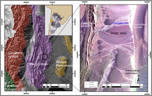
The area is located in the Province of San Juan, in the central-western Andean Precordillera of Argentina, extending between 31°1′10″ S and 31°1′42″ S latitude and 68°44′ W and 68°37′ W longitude, and lying at 800–600 m asl. It is bounded on the east by the ranges Sierra de Villicum and by Sierra de Talacasto on the west ().
Figure 1. Location of the study area and their location in San Juan province, Argentina. Left: Main geological structures and geomorphological units of the province of San Juan. Right: Landsat TM Image, combination of bands 7, 4 and 1.
The climate is arid to desertic (Bwk) (CitationKöppen, 1923), and daily and seasonal temperatures vary greatly: the extreme absolute temperatures reached 45°C. The annual mean temperature ranges from 14°C to 19°C. The annual rainfall values range within 100–124 mm (CitationPoblete & Minetti, 1989). Over 67% of the average annual precipitation (around 76.7 mm) falls from December to March in summer (CitationINTA, 2016). Precipitations are torrential, intense (between 5 and 20 mm) during a short duration (less than 30 min). Potential evapotranspiration largely exceeds precipitation, and has been estimated to be 1600 mm/year (CitationPoblete & Minetti, 1989). These characteristics associated with low mean annual precipitation generate the special conditions for the development of low shrub steppe with a coverage ratio below 30% (CitationBisigato, Villagra, Ares, & Rossi, 2009).
The streams draining the piedmont areas are seasonal, with active discharge occurring only during the rainy period. In the study area, the Talacasto river is the most important course which flows down in a west–east regional slope across the Talacasto range and converges into the Matagusanos tectonical depression.
3. Geological setting
The Precordillera Geologic Province is located on the eastern part of the Central Andes Chain, and it is composed mainly of Paleozoic sedimentary rocks. Based on its lithological features, age and deformation style, this geologic province is divided into Western, Central and Eastern sections, following the division proposed by CitationHeim (1952), CitationBaldis and Chebli (1969) and CitationOrtiz and Zambrano (1981), among other authors.
The Talacasto mountain range and piedmont, where the likewise-named alluvial fan is developed, belongs to the morphostructural area of Precordillera Central. The Matagusanos valley is developed in a regional tectonical depression, bounded by the Central Precordillera, toward the west, and the Eastern Precordillera, toward the east, respectively (CitationPerucca et al., 2012; CitationPerucca, Pantano, & Vargas, 2014) ().
The Central Precordillera is a north–south oriented mountain range, with elevations up to 3500 m asl. Overthrust faults verge eastwards, with detachment planes exposing Cambrian formations. The Lower Paleozoic deformation is strong in some units. On the other hand, the morphostructural unit of the Eastern Precordillera is different from that of the Central Precordillera, especially with respect to deformation vergence, which is dominantly westward, as well as on its N-S trending lithological variety. Thrust faults expose Paleozoic and Cenozoic formations. These mountain systems are arranged along N-S direction, and reach maximum elevations of up to 2500 m asl. The area of the Talacasto river alluvial fan is an extensive basin developed originated in the mountains of the Precordillera Central and in parts of the Precordillera Occidental.
4. Methodology
This work integrates two aspects of the methodology of geomorphological mapping. The first one corresponds to the identification, analysis and recognition of the spatial distribution of the Talacasto River alluvial fan units and subunits. The second stage includes essentially detailed fieldworks on the alluvial fan.
Information resulting from the first and second stages was digitized. Vectors were discriminated and classified for obtaining a layer of different Quaternary geomorphological units.
4.1. Morphogenesis of alluvial fan deposits
The geotechnical characteristics of non-consolidated deposits are a key element in the classification process. In this work, we have identified four geomorphogenetic units (alluvial, playa lake, polygenic and erosional by neotectonic landforms) divided into 13 subunits. The delineation of preclassified units was supported by means of 1:25,000 scale panchromatic photographs provided by the National Geographic Institute of Argentina. In addition, a 12.5-m Alos Palsar digital elevation model (DEM) was obtained from the Alaska Satellite Facility website (https://www.asf.alaska.edu) for the digital analysis of relief and morphometry. The software tool SAGA GIS v2.2 (CitationConrad et al., 2015) was used to obtain thematic map layers, such as slope, curvature, hillshade, orientation and channel network. These layer maps were used as a database for the interpretation and elaboration of the main map to scale 1:50,000.
The Talacasto river alluvial fan presents various landform subunits separated by erosion degrees, height above the channel network, properties and thickness of quaternary deposits, degree of development of the desert pavement, and presence or absence of fragments of sedimentary rocks of Miocene age characteristics. Quaternary surface levels were discriminated according to: desert varnish intensity and topographic position in relation to the base level of present-day channels. In addition, a supervised classification of Landsat TM images (date: 29 June 2012 path/row: 232/82) to create a landcover map was made using ArcGIS 9.2.
4.2. Morphodynamic analysis of deposits
Different processes of erosion and accumulation were identified, as well as different levels of accumulation, fault slopes, lithological scarps, geological outcrops and sediment properties. Landform unit classification was made by employing morphogenetic and morphodynamic criteria. In addition, in the delimited region, the quaternary tectonic activity has modified and changed the original position of the unit levels (CitationCalmels & Carballo, 1999), and in this alluvial fan, some landforms are exhumed and elevated by neotectonic processes. These neotectonic processes were evaluated throughout the alluvial fan and classifying the units in exhumed and erosional landforms induced by neotectonic activity.
All the data obtained were used in the elaboration of the main map. Finally, the geomorphological map was made to scale 1: 50,000. The reference Coordinate system used was UTM zone 19 south and WGS84 datum. All information was processed with ArcGis 9.2 software.
5. Results
5.1. Geomorphology
The Talacasto river, as well as other important rivers of San Juan, deposited large and thick alluvial fans during the Pleistocene. CitationSuvires (2014) describes and analyzes two megafans of the Late Pleistocene corresponding to the San Juan River. The past climate conditions of the Andes glaciers and the periglacial environment developed in Precordillera favored the formation of these fans with paraglacial deposits. Currently, these fans constitute paleoforms that evince paleoclimatic conditions.
5.2. Geomorphological units
5.2.1. Exhumed and erosional landforms induced by neotectonic activity
The structures connected to Andean tectonics are manifested in a thrust system. The main faults are arranged along the eastern border of the Talacasto orographic system, overlapping Paleozoic rocks on Neogene rocks. Toward the Eastward from the Talacasto range, outcrops of Neogene rocks are largely covered by Quaternary deposits. Furthermore, the fault affects the Neogene outcrops, forming a pair of syncline and anticline folds with subvertical flanks and axial traces with NNW orientation. These traces are oblique to the Talacasto thrust fault. In the Talacasto alluvial fan, Neogene outcrops with Quaternary cover represent topographical features of blind thrust faulting. These structures were formed during the evolution of the front of thrust faulting, through the development of fault propagation folds. The local of such folding and stepped faults layout suggests that they have developed strike-slip faults, whose movement could have a dextral transcurrent component (CitationCardinali, Baraldo, Moyano, Fernandez, & Merino, 2016).
Exhumed and erosional landforms induced by neotectonic activity correspond to two formations: (a) The Albarracín formation, that is arranged in a proximal sector of the alluvial fan, composed of sandstones, mudstone and fine conglomerates, with intercalations of tuffs partially altered to bentonites. Lenses of coarse sandstones and conglomerates of poorly selected material in a sandy matrix are found toward the roof. The clasts consist of rhyolites and andesites and in a smaller volume, granites and sandstones (CitationLeveratto, 1968). As an additional feature, the Mogna formation is composed of polygenic conglomerates that are distributed in lenticular strata (CitationKelly, 1962).
5.2.2. Alluvial landforms
5.2.2.1. Eight levels were differentiated
The first and second alluvial levels are located in the middle sector of the fan, protected by Neogene formations although modified by neotectonic activity. The first level is 4 m above the base level and is covered by an intense film of desert varnish, and the desert pavement is consistent throughout the level ((b)). Excavating the desert pavement, there arises a 0.3-m layer of clay that hosts small and angular clasts contributing to deposit impermeability ((a)). Thermoclastism is a process present in rocks of all levels. The second alluvial level is 3 m above the base level of the Talacasto river. It is similar to the first level located 1 m higher, this difference in height is a consequence of neotectonic processes. The clasts are less intensely varnished than those of the first level and a higher frequency of thermoclastism was observed ((b)).
Figure 2. (a) First-level alluvial fan covered with desert pavement; (b) Second-level glacis truncates rocks of Mogna formation and is covered with gravel; (c) First-level glacis truncates rocks of Albarracín formation; (d) Matagusanos playa lake, flow direction to the east, arrows indicate headward erosion.
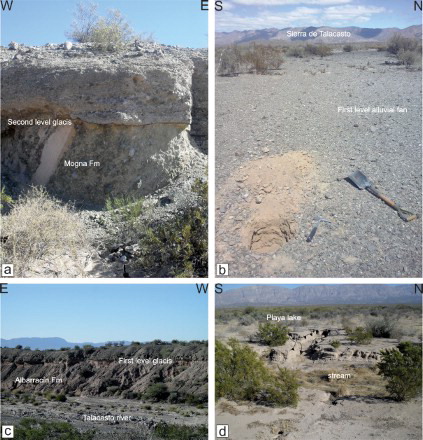
Figure 3. From the first to the eighth alluvial levels, the desert varnish cover of the deposits decreases in intensity, accompanied by an increase in the vegetation cover and clasts size heterogeneity.
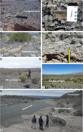
The third and fourth levels lay 2 m above the base level of the river (level 8). The third level shows graywacke rocks with a higher degree of desert varnish cover; the size of clasts is larger and is covered by shrub vegetation ((c)). The fourth level has a lower degree of varnish coverage and the clasts are smaller. Vegetation cover is dominated by cactus. These characteristics may indicate a higher edaphic aridity of this level (CitationWood, Graham, & Wells, 2005) ((d)). Although both levels lay at the same topographic height, the spatial arrangement is different because the third level spreads heterogeneously on the fan, whereas the fourth level lays in the central sector of the fan (Main Map).
The fifth level is located in the south and distal sector of alluvial fan, and it corresponds to superimposed deposits sourced from a neighboring catchment. The desert varnish is more intense in graywacke rocks than in limestones. The sixth level consists of recent deposits distributed throughout the surface of Talacasto fan. Here, the influence of desert varnish is weak.
The seventh level corresponds to the current alluvial terraces that lay, depending on the sector of alluvial fan, between 0.5 and 1.3 m over eighth level. No development of desert pavements or varnish was observed.
The eighth level is the Talacasto river base level. This sector is composed of river bars formed by various hydrological phenomena. Of all alluvial levels, this is the most active and unstable deposit, here the vegetation is absent in the proximal sector but some trees of Prosopis chilensis (Algarrobo) and Cercidium praecox (Brea) grow by the riverbed and distal sectors. No development of desert pavement was observed.
As levels become older, the development of desert pavements, desert varnish and hardened or cemented soils increases (Meadows, Young, & McDonald Citation2008). This feature inhibits infiltration, therefore favoring rapid runoff during summer flashflood periods, with concentrated flooding on the distal sector of the alluvial fan, where National Route N° 40 is located.
5.2.3. Polygenetic landforms in covered glacis
Two subunits of this type of relief were identified. These units correspond to reliefs showing typical characteristics of this arid and seismic region. They are erosive surfaces, flat and moderately inclined to east on sedimentary pink rocks of the Miocene. Quaternary fluvial sediments cover these eroded surfaces.
The first glacis level is located in the proximal sector of the alluvial fan. The polymictic and angular conglomerates have a low degree of cementation, and lie in discordance with the Albarracín formation, and reach a 4-m thickness in some places ((c)).
The second level of glacis is located in the middle sector of the fan with a chaotic Quaternary cover and no stratification. Besides, this level comprises a discordance with the polymictic conglomerates of the Mogna Formation ((a)).
5.2.4. Playa lake landforms
Located in the Matagusanos depression, this type of relief class occupies the lowest part of the study area (870 m asl). Known locally as ‘barreales’, these areas correspond to playa lake units without salts but with the presence of sand dunes. The drainage is centripetal from the mountains located to the west and east.
The sediments of this playa lake are composed of clays and fine sandstones with parallel structures and cross lamination. This relief is highly dissected by gullies whose headward erosion causes subsequent relief degradation through changes in base levels ((d)).
6. Conclusion
A geomorphological map is presented at a scale of 1:50,000, showing the different relief subunits of the Talacasto river alluvial fan and detail labels that briefly describe the main processes involved in relief evolution during the Quaternary landscape evolution.
Processes associated with aridity and active tectonics drive both the dynamics and evolution of this alluvial fan.
Desert pavement and salt-hardened rock cause low infiltration. As a consequence, enhanced surface runoff triggered by heavy rain in summer and consequent flashfloods leads to alluvial hazards and damages in routes and roads.
The presence of tectonic processes and the relief deformations induced by Quaternary faults modifies the direction of the runoff and deposition zones. As a consequence, the recent landforms located near the base level (level 8) are more dynamic and show a more constant evolution than that of higher landforms.
In an early stage of formation, the south sector of the Talacasto fan coalesces with alluvial deposits that are derived from the neighboring catchments. In a recent step, the regional and local neotectonic effects forced the river to run north, toward the sector where it currently flows. At present, the spatial arrangement of landscape is being modified by hydrological processes. These water dynamics occur more intensely in landforms covered with desert varnish and with the presence of desert pavement, which give rise to superficial runoff toward the distal sectors of the fan, where the main route of San Juan (National Route 40) is currently running through.
The authors consider this contribution is a first approximation toward explaining the evolution of the Quaternary relief in these previously uninvestigated desert regions of San Juan. This research can be applied to identification and zonation of flood hazards, environmental management, road layout planning, design maintenance, among other engineering works.
Software
The program used for the design of the geomorphological map was Esri ArcGIS 9.2.
Geomorphological map Talacasto alluvia fan, Precordillera of San Juan, Argentina
Download PDF (10.7 MB)Acknowledgements
The authors thank Juliane Cron and Dr Duna Roda who contributed to this paper. Their useful suggestions and revisions greatly improved this manuscript. We especially appreciate the contributions of Dr. Tobias Heckmann. The authors also express their gratitude to Dr Yanina Esper for the vectorization of map layers and CONICET for supporting this research.
Disclosure statement
No potential conflict of interest was reported by the authors.
Related Research Data
References
- Baldis, B. A., & Chebli, G. (1969). Estructura profunda del área central de la Precordillera sanjuanina. Jornadas Geológicas Argentinas, 1(4), 47–65.
- Bisigato, A. J., Villagra, P. E., Ares, J. O., & Rossi, B. E. (2009). Vegetation heterogeneity in Monte Desert ecosystems: A multi-scale approach linking patterns and processes. Journal of Arid Environments, 73(2), 182–191.
- Calmels, A. P. Y., & Carballo, O. C. (1999). Geomorfología de las regiones secas. Universidad Nacional de La Pampa, Facultad de Ciencias Exactas y Naturales, Departamento de Ciencias Naturales.
- Cardinali, A., Baraldo, J., Moyano, E., Fernandez, R. Y., & Merino, M. (2016). Interpretación estructural de un sector del bloque corrido y plegado de Talacasto, Precordillera Central, Departamento de Ullum, San Juan. Acta Geológica Lilloana, 28, 70–76.
- Colombo, F., Busquets, P., Ramos, E., Vergés, J., & Ragona, D. (2000). Quaternary alluvial terraces in an active tectonic region: The San Juan River valley, Andean ranges, San Juan Province, Argentina. Journal of South American Earth Sciences, 13(7), 611–626.
- Conrad, O., Bechtel, B., Bock, M., Dietrich, H., Fischer, E., Gerlitz, L., … Bohner, J. (2015). System for automated geoscientific analyses (SAGA) v. 2.1.4. Geoscientific Model Development, 8(7), 1991–2007.
- Flores, G., & Suvires, M. (2012). Distribución y diversidad de hábitats en el humedal de la Reserva Natural Presidente Sarmiento, San Juan, Argentina. Revista mexicana de Biodiversidad, 83(1), 194–200.
- Hedrick, K., Owen, L., Rockwell, T., Meigs, A., Costa, C., Caffee, M., … Ahumada, E. (2013). Timing and nature of alluvial fan and strath terrace formation in the Eastern Precordillera of Argentina. Quaternary Science Reviews, 80, 143–168.
- Heim, A. (1952). Estudios tectónicos en la Precordillera de San Juan. Los rios San Juan, Jáchal y Huaco, Ed. Coni.
- INTA. (2016). Sistema de Información y Gestión Agrometeorológico (en linea). Retrieved from http://siga2.inta.gov.ar
- Kelly, J. (1962). Geología de la sierra de Moquina y perspectivas petrolíferas (Y.P.F, Informes inéditos Nos. 1157, 1158 Y 1159). Provincia de San Juan: Departamento de Jáchal.
- Köppen, W. (1923). Die climate der Erde. Berlin: Walter de Gruyter.
- Leveratto, M. (1968). Geología de la zona al oeste de Ullum-Zonda, borde oriental de la Precordillera de San Juan, eruptividadsubvolcanica y estructura. Revista de la Asociación Geológica Argentina, 23(2), 129–157.
- Lloret, G., & Suvires, G. (2006). Groundwater basin of the Tulum Valley, San Juan, Argentina: A morphohydrogeologic analysis of its central sector. Journal of South American Earth Sciences, 21(3), 267–275.
- Meadows, D., Young, M., & McDonald, E. (2008). Influence of relative surface age on hydraulic properties and infiltration on soils associated with desert pavements. Catena, 72, 169–178.
- Milana, J. (1994). Propuesta de clasificación de abanicos aluviales en base a los procesos sedimentarios asociados. 5 Reunión Argentina de Sedimentología, Provincia de Tucuman.
- Ocaña, R., Suvires, G., & Flores, D. (2016). Evolución del relieve de un frente montañoso y respuesta del sistema erosivo fluvial ante el forzamiento causado por la actividad tectónica (Andes centrales, provincia de San Juan, Argentina). Revista Mexicana de Ciencias Geológicas, 33(3), 329–341.
- Ortiz, A., & Zambrano, J. (1981). La provincia geológica Precordillera oriental. 8 Congreso Geológico Argentino, Provincia de San Luis.
- Perucca, L., Audemard, F., Pantano, A., Vargas, H., Avila, C., Onorato, M., … Esper, M. (2012). Fallas cuaternarias con vergencias opuestas entre precordillera central y oriental, provincia de San Juan. Revista de la Asociación Geológica Argentina, 70(2), 291–302.
- Perucca, L., Pantano, A., & Vargas, N. (2014). El braquianticlinal de Loma Negra: una estructura de plegamiento cuaternario en la Precordillera Central, provincia de San Juan. Revista de la Asociación Geológica Argentina, 71(3), 427–433.
- Poblete, A., & Minetti, J. (1989). Los mesoclimas de San Juan. Primera y Segunda parte (Informe Técnico N 11 del Centro de Investigación de San Juan (CISA)). UNSJ. Boletín.
- Rocca, J. (1968). Geología de los valles de Tulum y Ullum–Zonda. Provincia de San Juan. Plan de Agua Subterráneas. CFI. Tomos, 1, 1–200.
- St-Onge, Denis A. (1981). Theories, paradigms, mapping, and geomorphology. The Canadian Geographer/Le Géographecanadien, 25(4), 307–315.
- Suvires, G. (2004). Distribución de los suelos en función del relieve y de la neotectónica en la región sureste de la provincia de San Juan. Revista de la Asociación Geológica Argentina, 59(3), 376–384.
- Suvires, G. (2014). The paradigm of paraglacial megafans of the San Juan river basin, Central Andes, Argentina. Journal of South American Earth Sciences, 55, 166–172.
- Van Asselen, S., & Seijmonsbergen, A. (2006). Expert-driven semi-automated geomorphological mapping for a mountainous area using a laser DTM. Geomorphology, 78(3), 309–320.
- Venerdini, A., Sánchez, G., Alvarado, P., Bilbao, I., & Ammiratti, J. (2016). Nuevas determinaciones de velocidades de ondas P y ondas S para la corteza sísmica del terreno Cuyania en el retroarco andino. Revista mexicana de Ciencias Geológicas, 33(1), 59–71.
- Vitek, J., Giardino, J., & Fitzgerald, J. (1996). Mapping geomorphology: A journey from paper maps, through computer mapping to GIS and virtual reality. Geomorphology, 16(3), 233–249.
- Wood, Y., Graham, R., & Wells, S. (2005). Surface control of desert pavement pedologic process and landscape function, Cima Volcanic field, Mojave Desert, California. Catena, 59, 205–230.