
ABSTRACT
This paper introduces a novel geoheritage map of the Portofino Natural Park. The park is an internationally well-known area, protected since 1935, located in the Ligurian Apennines, 25 km E of Genoa. It has 80 km of hiking trails which are used by visitors all year around. The map was produced by combining geological and geomorphological data, geoheritage elements and data from hiking and tourist maps. It is intended to be a base map from which can be derived applied maps. With appropriate integrations and simplifications, these can be useful tools for the management of highly frequented protected areas. The methodological approach involved aerial photo interpretation, bibliographical research, field work and the use of data from the Park archives. The original base map was produced by using a Digital Terrain Model raster (5 m) and vector layers for the different cartographical elements.
1. Introduction
Geoheritage encompasses the valuable and significant geological and geomorphological elements of the landscape worthy of conservation (geosites): it is an important component of natural heritage and it often constitutes the ‘skeleton’ of the landscape (CitationReynard, Coratza, & Hobléa, 2016a; CitationSerrano & Gonzalez Trueba, 2011). Due to its scientific, social and economic implications, geoheritage aroused a strong interest within the scientific community, as shown by the vast amount of scientific literature in the field of geoheritage identification, assessment, promotion and management (cf. CitationBrilha, 2017; CitationCoratza & Hobléa, 2017 and reference therein; CitationGray, 2017).
At an international level, there is currently a great variety of thematic maps concerning geoheritage; since a single universally recognised legend is yet to be implemented, the maps can be very different, depending on aim, scale and target users (cf. CitationCarton, Coratza, & Marchetti, 2005; CitationCoratza & Regolini-Bissig, 2009). Recently, there has been new interest in geoheritage, as shown by the works of several authors, particularly in Europe, mainly in the field of geoheritage promotion (CitationBertacchini, Benito, & Castaldini, 2007; CitationBissig, 2008; CitationBrandolini, Faccini, Robbiano, & Bulgarelli, 2011; CitationCastaldini, Valdati, Ilies, & Chiriac, 2005; CitationFuertes-Gutiérrez & Fernández-Martínez, 2012; CitationMartinez-Graña, Goy Y Goy, & Cardeña, 2011; CitationOrrù & Panizza, 2009; CitationRegolini, 2012; CitationRovere, Vacchi, Parravicini, Bianchi, & Firpo, 2010; CitationZwoliński & Stachowiak, 2012).
Protected areas represent open-air laboratories where the conservation of geoheritage – and more in general of natural heritage – and its promotion through initiatives of public use (e.g. geotourism products, excursion and educational trails with panels, etc.) are the main objectives. For protected areas, a geoheritage map can represent a very useful tool for local authorities and geopark managers both for management and promotion purposes. This paper introduces a novel Geoheritage Map of the Portofino Natural Park (Italy) in the Eastern Riviera of Liguria (). The protected area is internationally well known for its unique landscape and the natural, artistic and cultural values (CitationBalletti & Soppa, 2015) and it recently became National Park. The map, which was produced in strict collaboration with the park managers, provides information about the geosites of the park and other features of interest (e.g. botanical, historical, archaeological elements, etc.). With appropriate integrations and simplifications, this map can be used to produce applied-derived maps like geotourism and geohazard maps for tourists and visitors and maps of the vulnerability of geosites due to both natural and human processes.
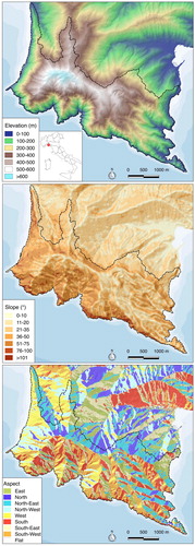
Figure 1. Digital elevation model (5 m × 5 m resolution) of the promontory with elevation, slope and aspect maps of Portofino Park (the dashed line shows the boundary of the Protected Area).
2. General settings
The Park of Portofino protects the Portofino Peninsula, located c. 18 km E of Genova, for a total surface of 1056.26 ha, of which 58.61 ha is a full protection area (5.5%), 597.31 ha is a natural-oriented area (56.5%), 362.50 ha is an area of protection (34.3%) and 37.84 ha is a development area (3.6%). A contiguous protected area of additional 932 ha adjoins the park.
The Park includes the municipalities of Camogli, Portofino and Santa Margherita Ligure; the frame area comprises Rapallo, Zoagli and Chiavari. The total resident population of the park is just over 750 inhabitants.
Due to its landscape and the natural and cultural values, the Portofino Peninsula has been a protected area for more than 80 years (Law n°1251/1935): since 1995, it has been managed by the Ente Parco Portofino Authority (Regional Law n° 12/1995), which re-designed the boundaries of the park (Regional Law n° 29/2001). Subsequently, the Portofino Protected Marine Area was created by an Environment Ministry Decree dated 26/04/1999, implementing Law n°979/1982. Recently, the new Law n° 394/91 instituted the National Park of Portofino, which includes both the continental and the marine sectors.
The Portofino Peninsula covers 18 km2 and has a 13 km long coastline; the orography is characterised by a mountain ridge with different elevations including Mt. Tocco (543 m), Mt. di Portofino (610 m), Mt. delle Bocche (506 m) and Mt. Pollone (472 m): this promontory breaks the continuity of the coast between Genoa and La Spezia.
The climate of Mt. di Portofino is Mediterranean, Csa according to Köppen, with hot summers, long periods of insolation, mild winters and rainy autumns (CitationSacchini, Ferraris, Faccini, & Firpo, 2012). At a local scale, different microclimates are conditioned by elevation, slope aspects and land use: this is particularly common along the southern side, usually hot and dry, where some short and narrow valleys have a humid and cool climate even in the middle of the summer, with high thermal excursion.
The park is an internationally acknowledged area of great landscape value for its historical settlements, vegetation and geomorphological features. The first villages date back to Roman times; in the Middle Ages several important religious buildings were established (e.g. San Fruttuoso, Cervara, Niasca and San Nicolò), linked by historical trails which are still in use. Due to the coexistence of Mediterranean, continental and mesophilic species, the vegetation of the park is of great interest. Terraces for agriculture, sustained by dry stone walls, constitute the most representative element of traditional human landscape of the park. The geomorphological dynamic is primarily shaped by gravity, water and wave motion, although geomorphological processes due to karstic phenomena, periglacial deposits and anthropic landforms are also found. Among the coastal landforms, the almost vertical conglomerate cliffs of the southern side of the promontory, more than 200 m high, are almost unique in the Mediterranean.
3. Material and methods
The workflow in summarises the different steps of the methodological process.
Figure 2. Flow chart of the methodological approach for the production of the Geoheritage map.
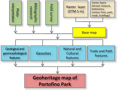
Firstly, thematic maps and scientific publications on the geology and geomorphology of the Park were gathered as well as aerial photographs and digital ortho-photographs; these were interpreted and integrated with fresh data from detailed field surveys. This process facilitated the identification of the principal abiotic features and tourist information of the area, which have been organised and implemented in a spatial geodatabase using a GIS (ArcGIS) software. In addition, a specific base map was realised for the purpose of this study: thematic layers such as isohyets, roads, buildings, trails and so on were overlaid on a Digital Terrain Model (res. 5 m).
Based on the information gathered in this first phase of the process, the geoheritage map was produced: the map has different levels of reading and four specific themes are shown in detail:
Geological and geomorphological features: geological and geomorphological data including landforms, deposits and geological elements obtained both from field surveys, official geological cartography and vector maps produced in specific studies of urban spatial planning (CitationAutorità di bacino regionale, 2015; CitationBoni et al., 1969; CitationServizio Geologico d’Italia, 1968).
Geosites: following a series of field surveys, sites of geological interest have been selected and classified according to their main scientific relevance in: geological, geomorphological, mineralogical-petrographical, hydrogeological and viewpoints (sensu CitationMigoń & Pijet-Migoń, 2017). The significance of geological elements was evaluated using the following criteria: intrinsic value; accessibility; state of conservation; visual impact; rarity; chronological and territorial distribution. All the geosites were identified, mapped and described according to the ‘Italian geosites inventory method’ and the data were collected into an easily updatable, interactive and flexible database.
Natural and cultural features: sites of tourist interest, including archaeological sites, historical buildings, terraced landscapes, artificial cavities and sites of botanical and ecological interest have been selected. The sites show the complex relationships between the unique and outstanding geological, biological and human heritage of the Portofino park.
Trails and path features: the map contains information on trails and footpaths, extracted from both the existing vector data and the archival information held by the Park of Portofino. The footpaths were classified according to their difficulty level (tourist, hiker, expert hiker, only with guide); two geo-touristic itineraries of the Park of Portofino were added as well (‘Le Vie del Conglomerato’).
4. Results: geoheritage map
4.1. Geological and geomorphological data
The geology of the Portofino Natural Park is characterised by the Conglomerate of Portofino (Conglomerato di Portofino) along the southern slope, while the marly limestone Flysch of Mt Antola (Calcari del Monte Antola) outcrops in its Northern part (). Today, the contact between these formations is considered a partial tectonic lineation which joins them with a WNW–ESE direction (CitationFaccini, Benedettini, Pelfini, & Brandolini, 2014).
Figure 3. Geological sketch map of the study area.
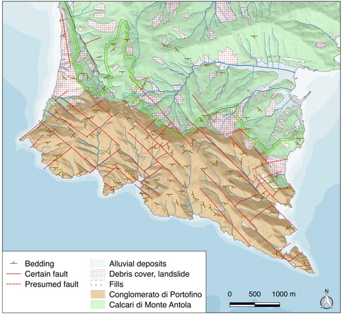
The Conglomerate of Portofino is characterised by clasts of marly limestone of centimetric or metric size and secondarily by sandstone: other lythotypes such as ophiolites, limestones, cherts, gneiss and schysts are less frequent (CitationBrandolini, Canepa, Faccini, Robbiano, & Terranova, 2007; CitationGiammarino & Messiga, 1979; CitationGiammarino, Nosengo, & Vannucci, 1969). Interlayers of sandstone are also found with thin coal interlayers. The conglomeratic complex shows variable dispositions: near Portofino, the dip direction is towards SSW, in the area of San Fruttuoso it is towards S, while at the western edge, by Punta Chiappa, it is towards SE. The dips are no more than 20°.
Two lineation systems with some faults are identified, with direction NW–SE and NE–SW; their superimposition causes the disintegration of the rock in large blocks. Due to lack of precise paleontological data, the formation is loosely dated Oligocene. The Limestone of Mt. Antola, dated Cretaceous-Sup Paleocene, is a Flysch made by marly limestone and grey marls, with interlayers of marly shales, siltstones and calcarenites (CitationCimmino, Faccini, & Robbiano, 2004; CitationCorsi, Elter, & Giammarino, 2001; CitationMarini, 1981). The structural settings of the Flysch are related to several deformative events, both brittle and ductile; the outcrop level shows mainly isoclinal folds with vergence towards SSW and axe-oriented WNW–ESE.
The southern and western part of the Promontory is characterised by high rocky cliffs, shaped by the sea wave action. The active cliffs are from 25 to 50 high, and occasionally >50 m high in Punta del Buco, Punta Carega and Vitrale. Their mean gradient ranges between 45° and 65°, but some vertical cliffs are found as well, as like as some sectors with a gradient of 30°.
Some debris and rock falls are observed mainly along the southern slopes where the cliffs show heights >10 m: these were shaped by gravity as in the case of the rocky cliffs in the areas S of Mt. Tocco, in the eastern side of the Bay of San Fruttuoso, at Cala del Prato and Vitrale. Scarps are visible along the area located W of the ridge between Mt. Tocco and Mt. di Portofino: this is the activation surface of some well-known landslides located between San Rocco, Mortola and San Nicolò (CitationBrandolini, Faccini, Robbiano, & Terranova, 2007).
Loose and thin covers are spread over the whole territory, often remodelled to build terraces with dry stone walls. Colluvial deposits are found along the rivers such as in Paraggi and San Fruttuoso (CitationFaccini, Piccazzo, & Robbiano, 2008).
The sides sloping towards N and the Tigullio Gulf have a gentler morphology; they are characterised by loose covers mainly due to landslides triggered by the emplacement of the Conglomerate which has different geo-mechanic features from marly limestone Flysch.
Some landslides are historically known and have been active in recent times, such as in Gave, and they can constitute a potential risk for human settlements and hikers.
Due to the steepness of riverbeds and the thickness of loose debris, debris flows can be triggered after short and heavy rainfall events. In the past, these have already caused casualties and damages to buildings (CitationFaccini, Piccazzo, & Robbiano, 2009).
Natural caves, mainly generated by tectonic shifts and secondarily by processes of physical–chemical dissolution were mapped.
4.2. Geosites
The Portofino Park shows a great variety of geosites that have been selected according to their scientific interest as geological, geomorphological, mineralogical-petrographical, hydrogeological and viewpoints ().
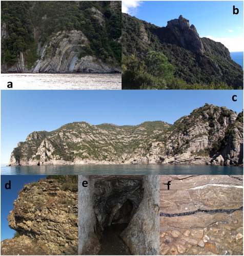
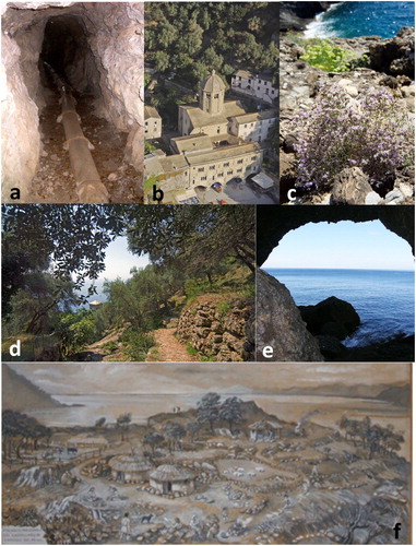
Figure 4. Geosites of the Portofino Park: (a) folds in marly limestones Flysch (see geosites list n. 3 in the Main Map), photo by A. Girani; (b) Mt. Campana from the Batterie geo-viewpoint, photo by F. Faccini (n. 35); (c) high rocky cliffs, photo by A. Girani (n. 10); (d) conglomerates, photo by A. Girani; (e) coal interlayers in conglomerate, photo by B. Mortola (n. 13); (f) Caselle spring, photo by F. Faccini (n. 18).
The sites of geological interest are mainly related to characteristic rocky outcrops which illustrate the geological history of the area. These are: the Conglomerate outcrops located in Pietre Strette, Punta Chiappa and along the footpath between the San Giorgio Church and the Lighthouse of Portofino (CitationFaccini, Piccazzo, Robbiano, & Roccati, 2008); the Flysch of Mt. Antola which shows its characteristic folded layers both along the western cliffs of the promontory and along the eastern side, by Punta Pedale.
Different examples of geomorphosites are found in the area of the park. For their singularity and high scientific value, landforms due to gravity and to coastal processes are the most representative geomorphosites of the park. Among the most interesting examples are the high rocky cliffs of the southern side, the huge boulders of Pietre Strette, the stacks spread along the coastline between Punta Pedale and the Castle of Paraggi (CitationFaccini et al., 2014) and the lateral spread phenomena of the Conglomerate which are visible in Mt. Tocco, Mt. Pollone and Mt. Croci di Nozarego.
The most significant mineralogical-petrographical examples are the clasts of anagenites along the footpath between Caselle and Pietre Strette, thin coal layers in the sandstone, the interlayers of the Conglomerate and outcrops located in two abandoned quarries of Flysch of Mt. Antola.
Hydrogeological sites include several springs located both along the fractures of the Conglomerate and along the contact with the Flysch of Mt. Antola; many water intake structures have a geoheritage value due to the historical underground tunnels such as Coppelli, Acquaviva and Caselle (CitationBonaria, Faccini, Galiano, & Sacchini, 2016).
Some viewpoints are listed as viewpoint geosites, sensu CitationMigoń and Pijet-Migoń (2017), described as ‘localities which offer a wider look at the surrounding landscape and hence, better understanding of its history’ (CitationMigoń & Pijet-Migoń, 2017). This category includes the conglomerate pinnacles in Batterie, Sella di Toca, Base O, Mt. Campana and Semaforo Nuovo, while the landscape shaped by the Flysch of Mt. Antola can be observed in the western side of the Promontory (San Rocco) and in Sotto le Gave in the eastern side.
4.3. Natural and cultural features
The unique geological and geomorphological features of the Portofino Natural Park are associated with botanical, historical and archaeological elements of regional significance.
Particular habitats such as the wetlands of Cala dell’Oro, Vessinaro, Rio Gentile and the Acquaviva Valley where ferns like Osmunda regalis are found, have an important ecological value. Some rare rocky species (Saxifraga cochlearis e Limonium cordatum) can be found in the Conglomerate rocks of the Promontory.
Archaeological sites are significant heritage elements too (CitationDelfino, Faccini, & Firpo, 2008; CitationDe Vingo, 2012): the most remarkable ones are the medieval settlement of San Fruttuoso, the Neolithic site of Castellaro of Camogli (where a landslide occurred in the Bronze Age is documented) and the Cave of Eremita, which shows important historical-environmental elements.
The historical buildings of the Mt. di Portofino are mainly religious structures which represent important examples of stone-built cultural heritage (CitationDufour Bozzo, Cavana, & Calcagno, 2010). The Abbey of San Fruttuoso and the complex of San Nicolò are particularly significant. Other important buildings are the mills along the Acquaviva Brook with their mill canals and the sixteenth-century watchtowers spread along the coast.
Cultivated terraces are today recognised as an example of cultural landscape and the product of the interaction between geomorphological dynamics and human-made landforms (CitationVan Der Sluis, Kizos, & Pedroli, 2014): some interesting terraced areas are found in the park, including the ones in San Fruttuoso, Prato, Sant’Anna and Galletti (CitationPaliaga, Giostrella, & Faccini, 2016).
The Park also has some artificial cavities characterised by geological and cultural values such as the tunnels of the Via dei Tubi, the military tunnels of Le Batterie and the access tunnels to some properties in Portofino ().
Figure 5. Natural and cultural features of tourist interest: (a) Diavolo tunnel in the Via dei Tubi track, photo by F. Faccini (see natural and cultural features list n. 48 in the Main Map); (b) San Fruttuoso Abbey complex, photo by A. Girani (n. 30); (c) Ligurian statice, photo by A. Girani (Limoniumcordatum) (n. 23); (d) Terraced slope at San Fruttuoso, photo by A. Girani (n. 43); (e) Grotta del Dragone, photo by B. Mortola (see Cave list n. 15); (f) Neolitic settlement at Castellaro site, reconstruction at the Civico Museo Archeologico di Camogli (n. 29).
4.4. Path and trail features
The Park of Portofino is characterised by a dense network of trails for a total length of 80 km; the main gateways of the Park are San Rocco di Camogli, Portofino, Santa Margherita Ligure, Portofino Vetta and, from the sea, San Fruttuoso.
The footpaths are diverse and characterised by different lengths, difficulty levels and technical features. The trail network covers different morphological and topo-climatic contexts from the sea level up to 610 m asl on the top of Mt. di Portofino, with slopes up to >100%: unpaved footpaths are the most frequent ones, but there are also paved stretches (concrete and dirt roads), steep staircases, exposed stretches on rock secured with chains and trails only suitable to expert hikers (CitationBrandolini, Faccini, & Piccazzo, 2006).
There are two geothematic footpaths with numbered stops illustrating the geodiversity of the Conglomerate of Portofino: they are located in Punta Chiappa and between Gaixella and Felciara.
The number of accesses to the trail network of the Park of Portofino was monitored by using a series of eco-counters: this system was activated by the Park in 2006 in Pietre Strette and enlarged in 2009 with new monitoring stations in Fornelli, Via dei Tubi, Caselle, Passo del Bacio, Base O, Prato and Mulini (): transit through Pietre Strette raised from >73,000 passages/year in 2010 to 90,000 passages/year in 2011, with peaks of c. 1500 passages/day. More than 1000 passages/day were registered in Pietre Strette, Fornelli and Mulini and except for the Via dei Tubi in the remaining areas peaks >500 passages/day were registered.
Figure 6. Map of visits along the trails of the Park: ideogram of the number of passages recorded by the stations in 2015. The graph shows the monthly number of passages recorded at the station of Pietre Strette between 2006 and 2015.
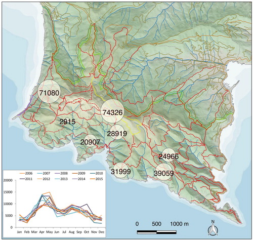
The visits are spread all year around for a total amount of >100,000 hikers: however, their frequency is variable. A peak is registered in May (mostly because of school trips, >11,000 visits), while the minimum number of visitors is in November and February, with c. 4500 hikers/month.
Outdoor activities have significantly grown over the last decades and today the area is increasingly visited throughout the year.
Despite a consolidated public awareness policy promoted by the Park, several accidents involving tourists and hikers are reported. The characteristics of the trail network and the geographical features of the territory make it necessary to wear appropriate mountain clothing and to be in good physical conditions. For this purpose, a statistic survey was carried out based on the rescue operations by the Italian Alpine and Speleological Rescue Corp between 1999 and 2015 (): an average number of >5 rescues/year is recorded, with a maximum value of 10 (2015) and a minimum of 2 (2001). The record data are too short to allow an assessment of statistical significance, but it underlines a growing number of accidents.
Figure 7. Map of the total number of rescues by the Italian Alpine and Speleological Rescue Corps (CNSAS) in Portofino Natural Park in the period 1996–2015. The graph shows the number of rescues in the period 1996–2015.
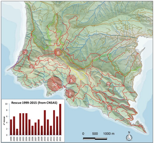
Adults between 31 and 65 years old are the most common age group: the rescues are spread throughout the week but the modal value shows that they prevail on Sundays and Fridays. The rescue operations occur in every month with higher concentrations between May and September in accordance with the number of visits recorded along the trails. The rescues mainly involved the footpath along an area W of San Fruttuoso called Passo del Bacio.
5. Conclusion and research perspective
Due to its potential high environmental impact, the growing demand of outdoor tourism constitutes a challenge for protected areas. The correct identification and knowledge of the landscape features and potential natural hazard can help to reduce the risk and the impact of tourism (CitationFaccini, Roccati, & Firpo, 2012; CitationLambiel, Maillard, Kummert, & Reynard, 2016). In this sense, thematic maps can be considered efficient tools to inform about geological and geomorphological landscape. The same map summarise the geological and geomorphological settings of an area, its geoheritage elements and potential natural hazards.
The Geoheritage map discussed in this paper is a novel product for the Portofino Park and can provide new insights into the appropriate management, conservation and enhancement of the landscape values of this outstanding territory (CitationReynard & Coratza, 2016; CitationReynard, Coratza, & Regolini-Bissig, 2009). Accurate studies and researches make it possible to develop new strategies of spatial planning and management of the territory which directly involves the local communities.
Due to the physical-geographical and geomorphological features of the park, some of the most challenging trails can pose a visitor safety issue: in the southern part, three trails that lead to San Fruttuoso develop through steep scarps and rocky valleys. The number of accidents occurred between Batterie and San Fruttuoso is still very high; therefore, risk mitigation strategies are necessary, including an information and education campaign on geology and environment. For this purpose, a detailed geo-hiking map will facilitate the simple yet rigorous communication of information about natural hazards associated with the geomorphological dynamics and meteoclimatic phenomena of the trail network.
Software
ArcGIS was used for the production of the geoheritage map, Adobe Reader and Microsoft Excel were used respectively for the related legend and for the diagrams and histograms.
Geoheritage map of the Portofino Natural Park (Italy).pdf
Download PDF (29.4 MB)Acknowledgements
The authors would like to thank Alberto Girani, Benedetto Mortola, Francesco Olivari, Claudio Solimano and Davide Virzi for some images and for the information given about the socio-economic and natural features of the territory.
Disclosure statement
No potential conflict of interest was reported by the authors.
Related Research Data
References
- Autorità di bacino regionale. (2015). Piano di Bacino stralcio per l’assetto idrogeologico, Ambito 15 [Basin master plan for the geo-hydrological arrangement]. Retrieved from http://www.pianidibacino.ambienteinliguria.it/GE/ambito15/ambito15.html
- Balletti, F., & Soppa, S. (2015). The landscapes of the Portofino natural regional Park. In R. Gambino & A. Peano (Eds.), Nature policies and landscape policies: Towards an alliance. Urban and Landscape Perspectives, 18 (pp. 415–422). Springer International Publishing. doi: 10.1007/978-3-319-05410-0_47
- Bertacchini, M., Benito, A., & Castaldini, D. (2007). Carta geo-archeo-turistica del territorio di Otricoli (Terni, Umbria). In Geologia e Turismo – beni geologici e geodiversità. Atti del 3° congresso nazionale, Bologna 1-2-3 marzo 2007, pp. 213–220. Bologna: Regione Emilia-Romagna – Associazione Italiana Geologia e Turismo. [Geo-archeo-tourist map of Otricoli (Terni, Umbria)].
- Bissig, G. (2008). Mapping geomorphosites: An analysis of geotourist maps. Geoturystika, 3(14), 3–12.
- Bonaria, V., Faccini, F., Galiano, I. C., & Sacchini, A. (2016). Hydrogeology of conglomerate fractured-rock aquifers: An example from the Portofino’s Promontory (Italy). Rendiconti Online Societa Geologica Italiana. Retrieved from http://rendiconti.socgeol.it/244/archivio_completo.html
- Boni, A., Braga, G., Conti, S., Gelati, R., Marchetti, G., & Passeri, L. (1969). Note illustrative della Cartageologica d’Italiaallascala 1:100.000, Fogli 83 (Rapallo) e 94 (Chiavari) [Explicative notes of Italian Geological Map at 1:100,000 scale, sheets 83 (Rapallo) and 94 (Chiavari)]. Ercolano, NA: Poligrafica e Cartevalori. Retrieved from http://193.206.192.231/carta_geologica_italia/note_illustrative/94.pdf
- Brandolini, P., Canepa, G., Faccini, F., Robbiano, A., & Terranova, R. (2007). Geomorphological and geo-environmental features of the Graveglia Valley (Ligurian Apennines). Geografia Fisica e Dinamica Quaternaria, 30, 99–116.
- Brandolini, P., Faccini, F., & Piccazzo, M. (2006). Geomorphological hazard and tourist vulnerability along Portofino Park trails (Italy). Natural Hazards and Earth System Sciences, 6, 563–571. doi: 10.5194/nhess-6-563-2006
- Brandolini, P., Faccini, F., Robbiano, A., & Bulgarelli, F. (2011). Geomorphology and cultural heritage of the Ponci Valley (Finalese karstic area, Ligurian Alps). Geografia Fisica e Dinamica Quaternaria, 34(1), 65–74. doi: 10.4461/GFDQ.2011.34.7
- Brandolini, P., Faccini, F., Robbiano, A., & Terranova, R. (2007). Geomorphological hazard and monitoring activity along the western rocky coast of the Portofino Promontory (Italy). Quaternary International, 171/172, 131–142. doi: 10.1016/j.quaint.2006.11.006
- Brilha, J. (2017). Geoheritage. In E. Reynard & J. Brilha (Eds.), Geoheritage: Inventories and evaluation (pp. 69–82). Amsterdam: Elsevier.
- Carton, A., Coratza, P., & Marchetti, M. (2005). Guidelines for geomorphological sites mapping: Examples from Italy. Géomorphologie: Relief, Processus, Environement, 11, 209–218. doi: 10.4000/geomorphologie.374
- Castaldini, D., Valdati, J., Ilies, D. C., & Chiriac, C. (2005). Geo-tourist map of the Natural Reserve of Salse di Nirano (Modena Appennines, Northern Italy). Il Quaternario, 18(1), 245–255.
- Cimmino, F., Faccini, F., & Robbiano, A. (2004). Stones and coloured marbles of Liguria in historical monuments. Periodico di Mineralogia, 73(Special Issue 3: a showcase of the Italian research in applied petrology), 71–84.
- Coratza, P., & Hobléa, F. (2017). The specificities of geomorphological heritage. In E. Reynard & J. Brilha (Eds.), Geoheritage: Assessment, protection, and management (pp. 87–106) (pp. 87–106). Amsterdam: Elsevier.
- Coratza, P., & Regolini-Bissig, G. (2009). Methods for mapping geomorphosites. In E. Reynard, P. Coratza, & G. Regolini-Bissig (Eds.), Geomorphosites (pp. 89–103). München: Pfeil.
- Corsi, B., Elter, F. M., & Giammarino, S. (2001). Structural fabric of the Antola Unit (Riviera di Levante, Italy) and implications for its Alpine versus Apennine origin. Ofioliti, 26(1), 1–8. Retrieved from http://www.ofioliti.it/index.php/ofioliti/article/view/126
- Delfino, D., Faccini, F., & Firpo, M. (2008). Un evento franoso dell’età del bronzo nel sito costiero instabile del Castellaro di Camogli (Promontorio di Portofino, Italia) [A bronze-agelandslideevent in the Castellaro di Camogli coastal site]. Atti del II Simposio Internazionale ‘Il Monitoraggio Costiero Mediterraneo: problematiche e tecniche di misura’ (pp. 459–466), Napoli 4–6 giugno.
- De Vingo, P. (2012). Medieval graves and funerary rites in Eastern Liguria. Archeologie Medievale, 42, 137–165. Retrieved from http://www.unicaen.fr/crahm/archeomed/spip.php?article333&lang=fr#5
- Dufour Bozzo, C., Cavana, M., & Calcagno, D. (Eds.). (2010). Sentieri sacri sul Monte di Portofino [Holypaths on Mount of Portofino]. Milano: Silvana Editoriale.
- Faccini, F., Benedettini, A., Pelfini, M., & Brandolini, P. (2014). La frana costiera delle Gave nel Promontorio di Portofino (Liguria, Italia): evoluzione recente e interazione con le opere antropiche [The Gave coastal landslide on the Portofino Promontory (Liguria, Italy): recentevolution and man-made landforminteraction]. StudiCostieri, 22, 33–44. Retrieved from http://www.gnrac.unifi.it/rivista/rivista.htm
- Faccini, F., Piccazzo, M., & Robbiano, A. (2008). Environmental geological maps of San Fruttuoso Bay (Portofino Park, Italy). Journal of Maps, 4(1), 431–443. doi: 10.4113/jom.2008.1018
- Faccini, F., Piccazzo, M., & Robbiano, A. (2009). Natural hazards in San Fruttuoso of Camogli (Portofino Park, Italy): A case study of a debris flow in a coastal environment. Italian Journal of Geosciences, 128(3), 641–654. doi: 10.3301/ijg.2009.128.3.641
- Faccini, F., Piccazzo, M., Robbiano, A., & Roccati, A. (2008). Applied geomorphological map of the Portofino Municipal Territory (Italy). Journal of Maps, 4(1), 451–462. doi: 10.4113/jom.2008.1023
- Faccini, F., Roccati, A., & Firpo, M. (2012). Geohiking map of Mt. Penna and Mt. Aiona area (Aveto Park, Liguria). Journal of Maps, 8(3), 293–303. doi: 10.1080/17445647.2012.722404
- Fuertes-Gutiérrez, I., & Fernández-Martínez, E. (2012). Mapping geosites for geoheritage management: A methodological proposal for the Regional Park of Picos de Europa (León, Spain). Environmental Management, 50(5), 789–806. doi: 10.1007/s00267-012-9915-5
- Giammarino, S., & Messiga, B. (1979). Clasti di meta-ofioliti a paragenesi di alta pressione nel Conglomerato di Portofino: implicazioni paleogeografiche e strutturali [Clasts of high-pressure meta-ophiolites in the Conglomerate of Portofino: paleogeographic and structural implications]. Ofioliti, 4(1), 25–41.
- Giammarino, S., Nosengo, S., & Vannucci, G. (1969). Risultanze geologico-paleontologiche sul Conglomerato di Portofino (Liguria Orientale) [Geological and palaeontological findings on Conglomerate of Portofino (Eastern Liguria)]. Atti Istituto di Geologia dell’Università di Genova, 7, 305–363.
- Gray, M. (2017). Geodiversity: The backbone of geoheritage and geoconservation. In E. Reynard & J. Brilha (Eds.), Geoheritage: Assessment, protection, and management (pp. 13–24). Amsterdam: Elsevier.
- Lambiel, C., Maillard, B., Kummert, M., & Reynard, E. (2016). Geomorphology of the Hérens valley (Swiss Alps). Journal of Maps, 12(1), 160–172. doi: 10.1080/17445647.2014.999135
- Marini, M. (1981). Analisi geologico strutturale e interpretazione paleogeografica e tettogenetica dei Calcari di M. Antola (Appennino ligure) [Structural geology analysis and palaeogeographic and tectogenetic interpretation of Calcari di Mt. Antolaformation, Ligurian Apennines]. Ofioliti, 6, 110–150.
- Martinez-Graña, A. M., Goy Y Goy, J. L., & Cardeña, C. Z. (2011). Natural heritage mapping of the Las Batuecas-Sierra De Francia and Quilamas Nature Parks (SW Salamanca, Spain). Journal of Maps, 7(1), 600–613. doi: 10.4113/jom.2011.1172
- Migoń, P., & Pijet-Migoń, E. (2017). Viewpoint geosites – values, conservation and management issues. Proceedings of the Geologists’ Association, 128(4), 511–522. doi: 10.1016/j.pgeola.2017.05.007
- Orrù, P., & Panizza, V. (2009). Assessment and management of submerged geomorphosites. A case study in Sardinia (Italy). In E. Reynard, P. Coratza, & G. Regolini-Bissig (Eds.), Geomorphosites (pp. 201–212). München: Pfeil.
- Paliaga, G., Giostrella, P., & Faccini, F. (2016). Terraced landscape as cultural and environmental heritage at risk: An example from Portofino Park (Italy). Annales, 26(3), 513–520.
- Regolini, G. (2012). Cartographier les géomorphosites. Objectifs, publics et propositions méthodologiques (PhD thesis). University of Lausanne. Institut de géographie, Lausanne, Géovisions 38, 294 pp.
- Reynard, E., & Coratza, P. (2016). The importance of mountain geomorphosites for environmental education. Actageographica Slovenica, 56(2), 291–303. doi: 10.3986/ags.1684
- Reynard, E., Coratza, P., & Hobléa, F. (2016a). Current research on geomorphosites. Geoheritage, 8(1), 1–3. doi: 10.1007/s12371-016-0174-3
- Reynard, E., Coratza, P., & Regolini-Bissig, G. (Eds.) (2009). Geomorphosites. München: PfeilVerlag.
- Rovere, A., Vacchi, M., Parravicini, V., Bianchi, C. N., & Firpo, M. (2010). Bringing geoheritage underwater: Methodological approaches to evaluation and mapping. In E. Reynard, P. Coratza, & G. Regolini-Bissig (Eds.), Mapping geoheritage, Géovisions 35 (pp. 65–80). Lausanne: Institut de géographie.
- Sacchini, A., Ferraris, F., Faccini, F., & Firpo, M. (2012). Environmental climatic maps of Liguria. Journal of Maps, 8(3), 199–207. doi: 10.1080/17445647.2012.703901
- Serrano, E., & Gonzalez Trueba, J. J. (2011). Environmental education and landscape leisure. Geotourist map and geomorphosites in the Picos de Europa National Park. Geojournal of Tourism and Geosites, 8, 295–308. Retrieved from http://gtg.webhost.uoradea.ro/PDF/GTG-2-2011/13_99_Serrano_Trueba.pdf
- Servizio Geologico d’Italia. (1968). Carta Geologica d’Italia, scala 1:100000, Foglio 94 ‘Chiavari’ [Italian Geological Map at 1:100,000 scale, Sheet 94 ‘Chiavari’] (2nd ed.). Roma: A.L.I. Arte Litografica Italiana. Retrieved from http://193.206.192.231/carta_geologica_italia/tavoletta.php?foglio=94
- Van Der Sluis, T., Kizos, T., & Pedroli, B. (2014). Landscape change in Mediterranean farmlands: Impacts of land abandonment on cultivation terraces in Portofino (Italy) and Lesvos (Greece). Journal of Landscape Ecology, 7(1), 23–45. doi: 10.2478/jlecol-2014-0008
- Zwoliński, Z., & Stachowiak, J. (2012). Geodiversity map of the Tatra National Park for geotourism. QuaestionesGeographicae, 31(1), 99–107. doi: 10.2478/v10117-012-0012-x