
ABSTRACT
A 1:10,000 scale landslide inventory map has been prepared for the Basilicata region (southern Italy) through extensive geomorphological analyses based on aerial photo-interpretations and field surveys. The study area (about 8000 km2) includes different morpho-structural domains of the southern Italian Apennines, and our results suggest that mass movement processes are mainly related to the intrinsic fragility of the landscape, which is featured by high relief and widespread outcrops of clay-rich deposits. As a matter of fact, the landslides of the inventory map cover about 4.8% of the surface area of the Basilicata region, whereas the total percentage of the area covered by the landslides reaches a value of 7.7%, if one considers also the landslides surveyed in previous works.
1. Introduction
The knowledge of the spatial and temporal distribution of landslide phenomena is crucial to investigate many issues of landscape evolution and its relationships with human activities and land management. The Italian territory is largely affected by landslide phenomena, which caused victims and damage to infrastructures as well as cultural heritage. Due to the importance of landslide mapping to assess landslide susceptibility and hazard, inventory maps have been extensively compiled at different scales and by different methods and criteria over the entire Italian territory, although a good cartographic coverage at a national scale needs more effort. In fact, many authors provide detailed studies of a single landslide or landslide phenomena at a catchment scale (CitationAringoli, Gentili, Materazzi, & Pambianchi, 2010; CitationBentivenga, Capolongo, Palladino, & Piccarreta, 2014; CitationBentivenga, Palladino, & Caputi, 2012; CitationConforti, Muto, Rago, & Critelli, 2014; CitationConforti, Pascale, & Sdao, 2015; CitationConforti, Pascale, Pepe, Sdao, & Sole, 2013; CitationGuida, Pelfini, & Santilli, 2008; CitationGulla’ & Sdao, 2001; CitationLazzari, Gioia, Piccarreta, Danese, & Lanorte, 2015; CitationMagliulo, Di Lisio, Russo, & Zelano, 2008; CitationParise & Wasowski, 1999; CitationPascale et al., 2013; CitationSantangelo, Gioia, Cardinali, Guzzetti, & Schiattarella, 2014; among others), but the usefulness of these maps for land management and planning is rather limited due to their inhomogeneous spatial distribution and the use of different mapping and classification criteria and methods (CitationGuzzetti et al., 2012). Large-scale landslide inventory maps can overcome these problems and limitations but they are quite rare in Italy. Between 2008 and 2014, CNR-IBAM and Basilicata Regional Authority developed a research project entitled Protect Cult (http://protect-cult.ibam.cnr.it/login_cnr), which was conceived to fill this gap in the Basilicata region through the creation of a 1:10,000-scale landslide inventory map. The general goal of the project has been the census of landslide processes of the Basilicata region and the investigation of the relationships between mass movement processes and the cultural heritage (CitationLazzari, 2011). A landslide map of a large area of the central-western Basilicata has been recently published (CitationLazzari & Gioia, 2016). This paper introduces the results of the landslide mapping of the entire regional territory (surface area of about 8000 km2) including a large sector of the southern Apennine chain and Bradano foredeep basin (southern Italy). Landslide inventory map has been produced according to the procedure and recommendation of the IFFI national project (Inventory of Landslide Phenomena in Italy, CitationTrigila, Iadanza, & Spizzichino, 2010), In particular, detection and mapping of landslides has been carried out by implementing a classical geomorphological approach based on the multitemporal analysis of stereoscopic aerial-photos and the field control of landslide types, pattern and evolution. The landslide inventory includes all the recognized landslides at a 1:5000 scale and can be classified as a geomorphological historical inventory (sensu CitationGuzzetti et al., 2012). The produced landslide inventory has also been statistically compared with the main topographical and lithological features of the study area in order to infer the main predisposing factors promoting the initiation and the evolution of landslide processes. Finally, a comparison between landslide area and land use classes has also been carried out.
Our inventory represent a homogeneous census of landslide processes over the entire region and can be a basic and effective tool to: (i) delineate the distribution and recurrence of the slope failure processes; (ii) investigate the landslide susceptibility and hazard; (iii) to extract the thresholds of rainfall-induced landslides (see e.g. CitationLazzari, Piccarreta, & Capolongo, 2013); (iv) study the evolution of landslide phenomena in areas of high cultural value (see e.g. CitationLazzari & Gioia, 2017).
2. Geological and geomorphological setting
The southern Apennines are a northeast-verging fold-and-thrust belt developed from the Late Oligocene on the western border of the African-Apulian plate. The tectonic units of the belt are mainly composed of shallow-water and deep-sea sedimentary covers, deriving from Mesozoic–Cenozoic circum-Tethyan domains (CitationMenardi Noguera & Rea, 2000; CitationPescatore, Renda, Schiattarella, & Tramutoli, 1999), covered by Neogene–Pleistocene foredeep and satellite-basin deposits, which are diachronically involved in thrusting from the inner sectors to the outer ones (CitationMalinverno & Ryan, 1986). The foreland area is represented by the Apulian carbonate platform and represents the lower and subducting plate of the orogenic system. Starting from the Tortonian, the contractional structure of the orogeny is strongly complicated and dismembered by low-angle and high-angle extensional tectonics, which have promoted the creation of low-relief structural ridges alternated with structural depression (CitationSchiattarella, Giano, & Gioia, 2017 and references therein). The late Pliocene – Early Pleistocene evolution of the chain is featured by transpressional and transtensional tectonics with a moderate relief growth, whereas high-angle extensional faulting took place in mid-Pleistocene times in the axial zone of the chain and is responsible for the formation of many intermontane basins both along the chain axis and on the Tyrrhenian (i.e. ‘internal’) belt, filled by Quaternary slope breccia, alluvial and lacustrine deposits, often faulted and uplifted (CitationGiano, Gioia, & Schiattarella, 2014; CitationGioia, Schiattarella, Mattei, & Nico, 2011; CitationSchiattarella, Di Leo, Beneduce, & Giano, 2003).
Geomorphological features and spatial distribution of landslide phenomena of the Campania-Lucania Apennine and the Bradano foredeep are strictly connected to the tectonic evolution and relief growth of the chain, which controlled also the distribution of the main geological units and their litho-technical features. Landscape and litho-structural features allowed us to individuate different morphotectonic domains along a SW-NE transect, which exhibit peculiar characters of slope failure processes: the inner and axial zone of the chain (south-west and southern sectors of the map) are mainly constituted by impressive mountain ridges, bordered by steep fault slopes (i.e. fault line scarps). These morphostructures are carved in Mesozoic shallow-water carbonate and in deep-sea sedimentary rocks of the same age (the non-metamorphic core complex of the chain; see CitationSchiattarella et al., 2003). Quaternary faulting and base-level lowering promoted the creation and evolution of tectonic depressions, which are occupied by a thick succession of Pliocene–Pleistocene clastic deposits or by widespread outcrop of clay-rich deposits (CitationSchiattarella et al., 2017 and references therein). Such tectonic depressions are crossed by longitudinal V-shaped valleys with thalwegs generally between 500 and 700 m a.s.l. (CitationGioia, Martino, & Schiattarella, 2011; CitationSchiattarella, Giano, Gioia, Martino, & Nico, 2013). Another peculiar feature of these sectors of the chain is the presence of several orders of low-angle erosional surfaces, which are arranged in a staircase geometry between 500 and 2000 m a.s.l. above the present-day thalwegs (CitationSchiattarella et al., 2017 and references therein). High-relief, deep incision of the fluvial net and the outcrop of poly-deformed and clay-rich lithological complexes represent the main control factors for the development and the evolution of large deep-seated complex landslides, which are frequently located along the tectonic contacts between rocks of different geotechnical parameters (CitationLazzari & Gioia, 2016; CitationSantangelo et al., 2014). Moreover, rockfall phenomena and debris flows are preferentially distributed along the escarpments of tectonic origin and their occurrence is controlled by both the high degree of fracturation and the impressive topography.
The outer zone and the front of the chain are featured by NW-SE-trending morpho-structural ridges and thrust sheets, which are mainly carved in Cretaceous-to-Miocene pelagic deposits (CitationPescatore et al., 1999). These landforms are transversally incised by the main rivers of the Basilicata region flowing into the Ionian Sea. The main rivers have a parallel pattern on a regional scale and generally show low- and very low slope angle profiles in the middle and lower reaches. The landscape exhibits a gentler topography and mass movement processes are mainly related to widespread earth flows and shallow landslides. The easternmost sector of the study area is featured by a hilly landscape formed by flat landforms and badlands, partly coinciding with the foredeep of the Apennines chain, filled by marine-to-continental Pliocene-Quaternary clastic sediments (CitationLazzari, 2008; CitationLazzari & Pieri, 2002). Main landslide types of this sector are earth flows and shallow slope failures.
3. Materials and methods
Landslide inventory map has been drawn according to the criteria and methods of the Italian Landslide Inventory (IFFI) project (see CitationTrigila et al., 2010 for some more details about the data stored in a IFFI-type geo-database). The first step was the recognition and the geographical location of landslide phenomena reported in historical sources, archive documents and newspapers (CitationLazzari, 2014 and references therein). Moreover, we integrated the historical data with the information collected in the catalogues of sites affected by landslides (AVI and SCAI projects, see CitationGuzzetti, Cardinali, & Reichenbach, 1994; river basin plans, PAI – Law 267/98). All these landslide phenomena have been included in the map and represent the pre-existing landslide inventory (see the Main Map attached).
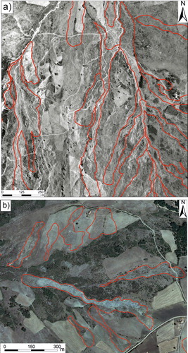
Landslide mapping has been realized through a systematic multitemporal photo-interpretation of 1:33,000 and 1:15,000 scale aerial photographs (1974, 1975 and 1991 years), ortophotos at 1:10,000 scale (1998, 2008, 2013 years, see (b)) and field surveys (2008–2014 years). Landslide classification has been based on the scheme proposed by CitationCruden and Varnes (1996). The landslide mapping has been performed using the consolidated procedure of photo-interpretation of different sets of stereoscopic aerial-photos (example in (a); see e.g. Guzzetti, Malamud, Turcotte, & Reichenbach, Citation2002 or CitationSantangelo et al., 2014 for some more details about the criteria and advantages of a similar approach). Systematic photo-aerial interpretation has been integrated with an extensive field control of each recognized landslide, which allowed us to acquire additional information about the main geomorphic elements and topographic signatures related to mass movement processes and their interpretation in term of pattern, distribution, state of activity and evolution of slope processes. In particular, the geomorphological field survey has been focused on: (i) the validation of the information acquired by aerial photo-interpretation; (ii) recognition of landslide types and state of activity; (iii) analysis of deposits involved in slope failures; (iv) evaluation of damages to infrastructures. All these data have been summarized in the IFFI landslide data sheet (see CitationTrigila et al., 2010).
Figure 1. (a) example of a b/w aerial photograph (1:15,000 nominal scale, year 1974) showing the geomorphological pattern of widespread earth-flow phenomena affecting a slope located about 10 km to the east of the Potenza city. (b) Interpretation of mass movement processes occurring in a slope near the Albano di Lucania town (central sector of the region) through the visual inspection of a high-resolution ortho-rectified image (year 2008).
The map includes badland areas since these landforms represent sectors of accelerated erosion and can promote the initiation and development of mass movement processes (see e.g. CitationDella Seta, Del Monte, Fredi, & Palmieri, 2007; CitationLazzari et al., 2015).
The mapped features were digitized and stored, with the aid of the ArcGIS platform, in a geo-database using a 1:10,000 scale topographic base map as a reference; the collected geo-database includes geographic and alphanumeric (i.e. landslide type, lithological and geotechnical features, land use, damage, etc.) information of each landslide and is available in Main Map. The final step of the preparation of the landslide inventory map is the overlay of each landslide area and relative classification on a smaller-scale (1:100,000) and digital topographic map.
In order to infer the spatial distribution of landslides and its relations with predisposing factors and triggering factors, a statistical analysis of the surveyed landslides has been carried out. The statistical characterization includes both frequency-area distribution (CitationGuzzetti et al., 2002) and GIS-aided analysis of the relationships between landslide occurrence and geological and geomorphological factors. To this scope, a lithological and land use maps have been derived from literature data and new investigations. More specifically, lithological features have been derived by the revision of the data from several geological maps, which allowed us to obtain a lithological map with a synoptic scheme of the main lithological classes outcropping in the different sectors of the study area. The information on land use has been acquired from a detailed (i.e. 1:5000 scale) inventory of land use/vegetation cover provided by the Basilicata Regional Authority (http://rsdi.regione.basilicata.it) and based on procedures and recommendations of the Corine Land Cover project (CitationBüttner, 2014 and references therein). Moreover, relationships between landslide areas and the main topographic features of the study area have been investigated using a DEM with a grid size of 5 m. DEM derivatives such as slope, curvature and aspect allowed us to infer the main relationships between landslide distribution and relief features.
4. Results
The study area is largely affected by landslides processes, and a visual inspection of the map reveals a strong control of topographical and litho-technical features on the spatial distribution of landslide phenomena. The inventory map includes 8711 new landslides, which are classified as follow: 3952 earth flows, 596 rotational slides, 43 translational slides, 312 falls/topples, 22 debris flows and 167 complex/compound landslides. Shallow landslides (i.e. the depth of the slip surface is lower than 3 m) cover an areas of 90.1 km2, whereas the badlands developed on a surface of 135.2 km2. The mapped landslides range in size from 3.64 × 10³ to 3.07 × 10⁶ m2, for a total landslide area of 477.1 km2, which corresponds to a landslide density of 4.8%. By combining our inventory with slope failures coming from previous studies (see the Main Map attached), a total landslide density of 7.7% can be obtained for the Basilicata region.
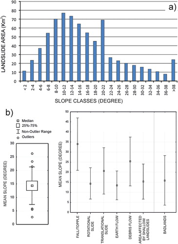
Qualitative and statistical analyses of the spatial distribution of landslide inventory map have been carried out in order to investigate the distribution of mass movement processes and their relationships with topography, landscape and lithology. The frequency distribution of the landslide area () deviates from the power-law distribution for a landslide area smaller than 0.05 km2, thus suggesting an incompleteness (sensu CitationGuzzetti et al., 2002) of the inventory for landslides smaller than this threshold area. The analysis of the relationships between the landslide area and the type of movements (see frame C in the attached Main Map) highlights that earth flows are the most representative landslide type with a landslide area of 171.5 km2, corresponding to 36.3% of the total landslide area. Shallow landslides and soil creep cover an area of about 90 km2 (18.8% of the landslide area), whereas the contribution of deeper-seated landslides such as rotational slides is lower (i.e. about 6% of the total landslide area). Finally, badlands cover a surface of 135.3 km2, corresponding to 28.3% of the landslide total area. Earth flows and areas affected by shallow landslides represent about 55% of the total landslide area (see frame A in the Main Map attached). Widespread earth flows and shallow landslides suggest a strong control of lithology on slope failure on the study area, which are mainly developed in clay-rich deposits and rocks such as foredeep silty-clay deposits and argillite complexes. Previous studies (see e.g. CitationLazzari et al., 2013; CitationSantangelo et al., 2013) and the analysis of landslide occurrence after several and extreme rainfall events occurred during the survey period indicate that heavy daily rainfalls are the main triggering factors of these slope failure processes. Rotational and translational slides are typically located in the southern Apennines chain along slopes with a high degree of litho-structural complexity, Quaternary tectonic activity and significant fluvial incision. shows some examples of the higher-impact and deeper-seated landslide phenomena occurred in the study area during the last years, which caused significant damage to building and viability. Falls and topples are typically located at the toe of steep slopes of impressive and tectonically-controlled morphostructures and a similar spatial distribution indicates that high relief and degree of tectonization represent the main predisposing factor for their occurrence. Debris flows have been mainly recognized at the termination of steep and minor valleys where unconsolidated gravels and sands, Quaternary in age, largely crop out. The analysis of the relationships between slope classes deriving by the 5 m DEM and landslide occurrence confirms a relevant role of local relief on the development of these landslide types since falls/topples and debris flows showed higher mean slope values ().
Figure 2. (a) Frequency-area distribution of inventory; (b) power-law scaling of binned landslide area data (blue circles represent the raw data, the exponent of the power law is 2.7). Rollover occurs at a threshold area of 0.05 km2.
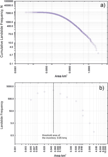
Figure 3. Some examples of the main landslide phenomena occurred in Basilicata during the field-survey period (2008–2014). Legend: (a) rotational landslide occurred in 2013 that affected the main entrance road to the village of Aliano; (b) translational landslide that destroyed the social center of the village of Stigliano (morphoevolution between 2013 and 2015); (c) landslide along the urban perimeter of Tolve (2013); (d) active mudflow landslide along the left bank of the river Basento in the municipality of Tricarico which led to the damming of the river and the formation of a landslide dam; (e) some details, detected by UAV images, of the damage caused by the large landslide event occurred in December 2013 in the village of Montescaglioso, where it is possible to see the main geomorphological features, the damaged buildings, the flow directions and the damaged roads; (f) a particular of the lateral cutting area of Montescaglioso landslide involving a municipal road and the adjacent building.
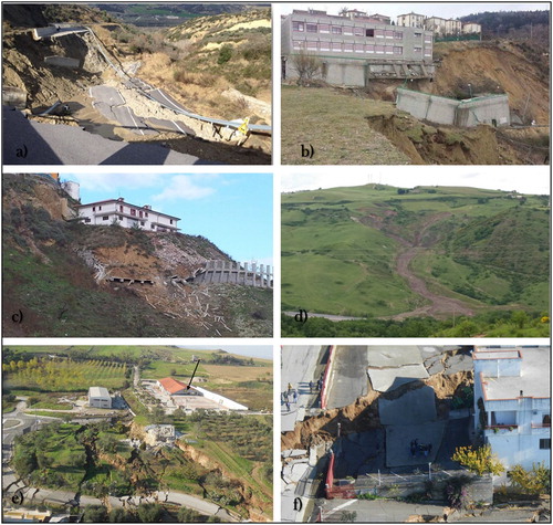
Figure 4. (a) Histogram showing the relationship between landslide area and slope classes; (b) box plot of the mean slope of each landslide for the entire inventory and for the different landslide types.
Landslide density map (see frame D in the Main Map attached) has been prepared using a cell size of 1 km and portrays the sectors of the study area where landslide processes are widespread. A visual inspection of the map highlights that the easternmost coastal sector and the northern one are the only sectors featured by widespread areas with a very low (<2%) density. On the contrary, the central and central-western sectors of the region, north-east sectors of the foredeep and the southernmost sectors are characterized by the largest amounts of cells with a very high density (>20%).
A comparison of land use map and landslide occurrence indicates that almost 60% of the mapped landslides occurred in arable lands and shrubland, seminatural areas and broad-leaved forests (see frame B of the attached Main Map). The same categories of land use have the higher values of areas affected by shallow landslides and earth flows. A significant percentage (i.e. about 15%) of the total landslide area affected the sclerophyllous vegetation. The analysis of the interaction between landslides and anthropic/artificial surfaces indicates that about 4100 landslides of the inventory have interacted with anthropic surfaces, urban fabric and main road networks. This simple statistical analysis provided a preliminary estimation of the high potential risk of the landslide phenomena in the study area.
5. Conclusions
Classical (i.e. aerial photo-interpretation and field survey) geomorphological investigation and the analysis of pre-existing landslide databases have been here used to produce a landslide inventory map of the Basilicata region, a 8000-km2 wide sector of southern Italy including different morpho-structural domains of the southern Apennine chain and Bradano foredeep basin. Our inventory consists of 8711 new landslides ranging in size from 3.64 × 10³ to 3.07 × 10⁶ m2, and a visual inspection of the map reveals a diffuse and non-homogeneous distribution of landslide processes. In fact, the percentage of the area affected by landslides is 7.7% of the total surface of the study area and the most representative (i.e. about 55% of the total landslide area) landslide phenomena are earth flows and areas affected by shallow landslides. Our data can represent a basic contribution to the evaluation of landslide susceptibility and hazard of the study area as well as a support for territorial planning and civil protection from many points of view.
Software
ESRI ArcGIS 9.3 was used to digitize the data collected during field survey and aerial photo-interpretation and to perform spatial analysis. DEM was derived from a digital topographic map of the Basilicata region. The final layout of the map was prepared in CORELDRAW X7. Vector files of the mapped landslides (SHP-format; coordinate system: UTM-WGS 1984, zone 33N) are available in Main Map.
Landslide inventory of the Basilicata region (Southern Italy).pdf
Download PDF (55.9 MB)Acknowledgements
We would like to thank Dr Massimo Conforti, Dr Giedrė Beconytė and Dr Daniel Hölbling for their constructive comments and careful revisions.
Disclosure statement
No potential conflict of interest was reported by the authors.
ORCID
Maurizio Lazzari http://orcid.org/0000-0002-7459-9090
Dario Gioia http://orcid.org/0000-0002-3394-3705
Related Research Data
References
- Aringoli, D., Gentili, B., Materazzi, M., & Pambianchi, G. (2010). Mass movements in the adriatic central Italy: Activation and evolutive control factors. In: E. D. Werner & H. P. Friedman (Eds.), Landslides: Causes, types and effects (pp. 1–71). New York, NY: Nova Science.
- Bentivenga, M., Capolongo, D., Palladino, G., & Piccarreta, M. (2014). Geomorphological map of the area between Craco and Pisticci (Basilicata, Italy). Journal of Maps, 11(2), 267–277. doi:10.1080/17445647.2014.935501.
- Bentivenga, M., Palladino, G., & Caputi, A. (2012). Development of Pietra Maura landslide and interactions with the Marsico Nuovo dam (Basilicata, Italy). Geografia Fisica e Dinamica Quaternaria, 35(1), 13–22. doi: 10.4461/GFDQ.2012.35.2
- Büttner, G. (2014). CORINE land cover and land cover change products. Remote Sensing and Digital Image Processing, 18, 55–74. doi: 10.1007/978-94-007-7969-3_5
- Conforti, M., Muto, F., Rago, V., & Critelli, S. (2014). Landslide inventory map of north-eastern Calabria (South Italy). Journal of Maps, 10(1), 90–102. doi: 10.1080/17445647.2013.852142
- Conforti, M., Pascale, S., Pepe, M., Sdao, F., & Sole, A. (2013). Denudation processes and landforms map of the Camastra river catchment (Basilicata – South Italy). Journal of Maps, 9(3), 444–455. doi: 10.1080/17445647.2013.804797
- Conforti, M., Pascale, S., & Sdao, F. (2015). Mass movements inventory map of the Rubbio stream catchment (Basilicata – South Italy). Journal of Maps, 11(3), 454–463. doi: 10.1080/17445647.2014.924038
- Cruden, D. M., & Varnes, D. J. (1996). Landslide types and processes. In A. K. Turner & R. L. Shuster (Eds.), Landslides: Investigation and mitigation (pp. 36–75). Washington, DC: National Academies Press.
- Della Seta, M., Del Monte, M., Fredi, P., & Palmieri, E. L. (2007). Direct and indirect evaluation of denudation rates in central Italy. Catena, 71(1), 21–30. doi: 10.1016/j.catena.2006.06.008
- Giano, S. I., Gioia, D., & Schiattarella, M. (2014). Morphotectonic evolution of connected intermontane basins from the southern Apennines, Italy: The legacy of the pre-existing structurally controlled landscape. Rendiconti Lincei, 25(2), 241–252. doi: 10.1007/s12210-014-0325-x
- Gioia, D., Martino, C., & Schiattarella, M. (2011). Long- to short-term denudation rates in the southern Apennines: Geomorphological markers and chronological constraints. Geologica Carpathica, 62(1), 27–41. doi: 10.2478/v10096-011-0003-1
- Gioia, D., Schiattarella, M., Mattei, M., & Nico, G. (2011). Quantitative morphotectonics of the Pliocene to Quaternary Auletta basin, southern Italy. Geomorphology, 134(3–4), 326–343. doi: 10.1016/j.geomorph.2011.07.009
- Guida, D., Pelfini, M., & Santilli, M. (2008). Geomorphological and dendrochronological analyses of a complex landslide in the southern Apennines. Geografiska Annaler, Series A: Physical Geography, 90(3), 211–226. doi: 10.1111/j.1468-0459.2008.340.x
- Gulla’, G., & Sdao, F. (2001. Dissesti prodotti o aggravati dal sisma del 9 settembre 1998 nei territori del confine calabro-lucano (Vol. 2121). Catanzaro: CNR-GNDCI, Rubbettino Industrie Grafiche ed Editoriali.
- Guzzetti, F., Cardinali, M., & Reichenbach, P. (1994). The AVI project: A bibliographical and archive inventory of landslides and floods in Italy. Environmental Management, 18(4), 623–633. doi: 10.1007/bf02400865
- Guzzetti, F., Malamud, B. D., Turcotte, D. L., & Reichenbach, P. (2002). Power-law correlations of landslide areas in central Italy. Earth and Planetary Science Letters, 195(3–4), 169–183. doi: 10.1016/S0012-821x(01)00589-1
- Guzzetti, F., Mondini, A. C., Cardinali, M., Fiorucci, F., Santangelo, M., & Chang, K. T. (2012). Landslide inventory maps: New tools for an old problem. Earth-Science Reviews, 112(1–2), 42–66. doi: 10.1016/j.earscirev.2012.02.001
- Lazzari, M. (2008). Il comportamento tettonico e sedimentario del bacino d’avanfossa Bradanica durante il Pleistocene inferiore. Memorie Descrittive della Carta geologica d'Italia, LXXVII, 61–76.
- Lazzari, M. (2011). Note illustrative della carta inventario delle frane in Basilicata centroccidentale. Potenza: Zaccara Editore, Lagonegro.
- Lazzari, M. (2014). Utilizzo delle fonti storiche per lo studio della pericolosità e del rischio geomorfologico. Memorie Descrittive della Carta geologica d'Italia, XCVI, 251–260.
- Lazzari, M., & Gioia, D. (2016). Regional-scale landslide inventory, central-western sector of the Basilicata region (Southern Apennines, Italy). Journal of Maps, 12(5), 852–859. doi: 10.1080/17445647.2015.1091749
- Lazzari, M., & Gioia, D. (2017). UAV images and historical aerial-photos for geomorphological analysis and hillslope evolution of the Uggiano medieval archaeological site (Basilicata, Southern Italy). Geomatics, Natural Hazards and Risk, 8(1), 104–119. doi: 10.1080/19475705.2017.1310762
- Lazzari, M., Gioia, D., Piccarreta, M., Danese, M., & Lanorte, A. (2015). Sediment yield and erosion rate estimation in the mountain catchments of the Camastra artificial reservoir (Southern Italy): A comparison between different empirical methods. CATENA, 127, 323–339. doi: 10.1016/j.catena.2014.11.021
- Lazzari, M., Piccarreta, M., & Capolongo, D. (2013). Landslide triggering and local rainfall thresholds in Bradanic foredeep, Basilicata region (Southern Italy). In C. Margottini, P. Canuti, & K. Sassa (Eds.), Landslide science and practice: Volume 2: Early warning, instrumentation and monitoring (pp. 671–677). Berlin: Springer.
- Lazzari, M., & Pieri, P. (2002). Modello stratigrafico-deposizionale della successione regressiva infrapleistocenica della Fossa bradanica nell’area compresa tra Lavello, Genzano e Spinazzola. Memorie della Società Geologica Italiana, 57, 231–237.
- Magliulo, P., Di Lisio, A., Russo, F., & Zelano, A. (2008). Geomorphology and landslide susceptibility assessment using GIS and bivariate statistics: A case study in southern Italy. Natural Hazards, 47(3), 411–435. doi: 10.1007/s11069-008-9230-x
- Malinverno, A., & Ryan, W. B. F. (1986). Extension in the Tyrrhenian Sea and shortening in the Apennines as result of arc migration driven by sinking of the lithosphere. Tectonics, 5, 227–245. doi:10.1029/ TC005i002p00227 doi: 10.1029/TC005i002p00227
- Menardi Noguera, A., & Rea, G. (2000). Deep structure of the Campanian-Lucanian Arc (Southern Apennine, Italy). Tectonophysics, 324, 239–265. doi: 10.1016/S0040-1951(00)00137-2
- Parise, M., & Wasowski, J. (1999). Landslide activity maps for landslide hazard evaluation: Three case studies from southern Italy. Natural Hazards, 20(2–3), 159–183. doi: 10.1023/A:1008045127240
- Pascale, S., Parisi, S., Mancini, A., Schiattarella, M., Conforti, M., Sole, A., & Sdao, F. (2013). Landslide susceptibility mapping using artificial neural network in the urban area of Senise and San Costantino Albanese (Basilicata, Southern Italy). Lecture Notes in Computer Science, 7974(PART 4), 473–488. doi:10.1007/978-3-642-39649-6-34 doi: 10.1007/978-3-642-39649-6_34
- Pescatore, T., Renda, P., Schiattarella, M., & Tramutoli, M. (1999). Stratigraphic and structural relationships between Meso-Cenozoic Lagonegro basin and coeval carbonate platforms in southern Apennines, Italy. Tectonophysics, 315(1–4), 269–286. doi: 10.1016/S0040-1951(99)00278-4
- Santangelo, M., Gioia, D., Cardinali, M., Guzzetti, F., & Schiattarella, M. (2014). Landslide inventory map of the upper Sinni River valley, Southern Italy. Journal of Maps, 11(3), 444–453. doi: 10.1080/17445647.2014.949313
- Schiattarella, M., Di Leo, P., Beneduce, P., & Giano, S. I. (2003). Quaternary uplift vs tectonic loading: A case study from the Lucanian Apennine, southern Italy. Quaternary International, 101–102(1), 239–251. doi: 10.1016/S1040-6182(02)00126-X
- Schiattarella, M., Giano, S. I., & Gioia, D. (2017). Long-term geomorphological evolution of the axial zone of the Campania-Lucania Apennine, southern Italy: A review. Geologica Carpathica, 68(1), 57–67. doi: 10.1515/geoca-2017-0005
- Schiattarella, M., Giano, S. I., Gioia, D., Martino, C., & Nico, G. (2013). Age and statistical properties of the summit palaeosurface of Southern Italy. Geografia Fisica E Dinamica Quaternaria, 36(2), 289–302. doi: 10.4461/Gfdq.2013.36.23
- Trigila, A., Iadanza, C., & Spizzichino, D. (2010). Quality assessment of the Italian landslide inventory using GIS processing. Landslides, 7(4), 455–470. doi: 10.1007/s10346-010-0213-0