
ABSTRACT
The paper presents a geomorphological map of the north-eastern coast of the Island of Gozo (Malta) integrating inland and offshore areas at the scale 1:15,000. The map derives from the integration of different methods, such as aerial photo interpretation, field surveys and analysis of seafloor bathymetry. The landforms identified on land were shaped by coastal, fluvial, karst and gravity-induced processes, and some of them prolong on the seafloor. Most of the submerged landforms appear to have been modelled in subaerial conditions during sea-level lowstands, having been sealed by the rising sea in post-glacial times. Two sketches accompany the Main Map showing the type and distribution of coastal geomorphotypes and the land cover of the area.
1. Introduction
The Island of Gozo is characterised by attractive and varied landscapes, though quite unexplored from a geomorphological perspective. Besides literature on the general aspects of coastal features (CitationFoglini et al., 2016; CitationMagri, 2006; CitationMicallef et al., 2013; CitationPaskoff & Sanlaville, 1978; CitationSaid & Schembri, 2010), only a few papers deal with the specific geomorphological aspects of the Island of Gozo (CitationGalve et al., 2015; CitationMottershead, Bray, Soar, & Farres, 2014; CitationSoldati, Tonelli, & Galve, 2013), some of them referring to its rich geoheritage (CitationCoratza, Galve, Soldati, & Tonelli, 2012, Citation2016). This paper provides the first detailed geomorphological mapping of an area in Gozo – the NE coast between the highly touristic area of Marsalforn and Ramla Bay and Ras il-Qala point – including also its continental shelf. The investigated area comprises ca. 17 km of coastline, extending inland for 1 km, and a discrete portion offshore, covering a total of about 18 km2. The integrated analysis of terrestrial and submarine landforms and processes has contributed to the improved comprehension of the geomorphological evolution of the area, which has also been largely influenced by sea level oscillations of the last glacial cycle. Indeed, the sea level dropped down to −130 m (CitationBenjamin et al., 2017; CitationLambeck, Rouby, Purcell, Sun, & Sambridge, 2014), making most of the continental shelf shallower than 130 m an emerged land modelled by subaerial processes successively drowned by the post-glacial marine transgression.
2. Regional setting
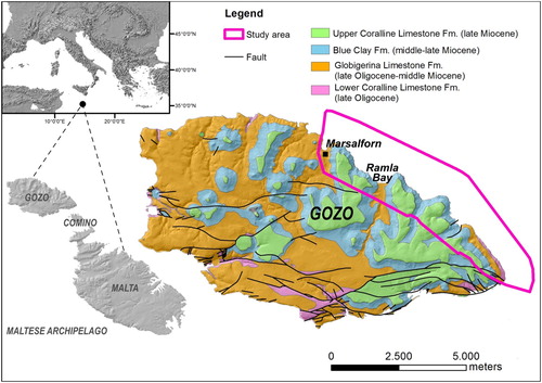
The Island of Gozo, with an area of 67 km², is the second largest island of the Maltese archipelago situated centrally in the Mediterranean Sea, about 90 km south of Sicily and 290 km north-east of Tunisia (). The rocks exposed there comprise a Late Oligocene-Miocene marine sedimentary succession of five lithostratigraphic units mostly composed of limestones and marls (; Pedley, 2002; CitationBaldassini & Di Stefano, 2017). Oldest to youngest, the units are Lower Coralline Limestone Formation Globigerina Limestone Formation, Blue Clay Formation, Greensand and Upper Coralline Limestone Formation. The oldest formation, the Lower Coralline Limestone Formation, consists of pale grey, hard, shallow marine biomicrites and biosparites (CitationPedley, Clarke, & Galea, 2002), and outcrops in a restricted coastal stretch forming subvertical cliffs. The Globigerina Limestone Formation appears as a yellowish, fine-grained, planktonic foraminiferal limestone and dominates in southern Malta and western Gozo. The Blue Clay Formation that consists of grey, soft marls, clays and silty sands, extensively outcrops along gentle slopes. Greensand is composed of bioclastic carbonate rock which is abundant in glauconite, and was deposited in a warm marine environment. The youngest unit, the Upper Coralline Limestone Formation, forms plateaus and is frequently weathered into steep cliffs and well-developed karst topography. The geological formations lie almost horizontally across the Islands showing a 5° tilting towards NE due to the upwarping of the NE shoulder of the Malta Graben, part of the Pantelleria Rift System and on which the Islands are settled (CitationAlexander, 1988).
Figure 1. Geographic and geodynamic setting of the Maltese Archipelago (central Mediterranean Sea).
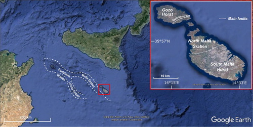
Figure 2. Geology of the Island of Gozo (CitationOil Exploration Directorate, 1993) and location of the study area.
The Maltese Archipelago is crossed by two fault systems: the ancient WSW-ENE-oriented fault system and the NW-SE-trending system (CitationGalve et al., 2015; CitationGardiner, Grasso, & Sedgeley, 1995; CitationJongsma, van Hinte, & Woodside, 1985). The first one is responsible for a horst and graben structure that involves the whole archipelago and the surrounding seafloor (CitationAlexander, 1988). The NW-SE system trends parallel to the Pantelleria Rift System and controls the NE and SE coasts orientation.
The climate of the Archipelago is typically Mediterranean. It is characterised by hot, dry and long summers, warm and short winters interspersed with short and relatively humid autumns and springs. The monthly mean temperature ranges from 12°C in January to 27°C in August and the annual precipitation is about 500 mm (CitationMalta International Airport Meteorological Office). Winds are frequent and strong; the predominant wind is the cold NW-blowing Mistral, ‘Majjistral’ in Maltese language. Other common winds are the dry Grecale that blow from the northeast and the Sirocco, a S-blowing wind common only in September.
3. Methods
The research included the following phases:
Detailed geomorphological field surveys (at 1:2000 scale) aimed at identification and mapping of: (i) processes and landforms, (ii) coastal geomorphotypes and (iii) land cover types within the study area;
Analysis and interpretation of Malta Planning Authority (MPA) aerial photographs dated 2012, taken from an altitude of 3,078 m with a spatial resolution of 15 cm, and of the most recent aerial photos (Citation2016), in order to support and integrate field observations;
Analysis and interpretation of processes and landforms from both a 10 m-resoluted multibeam bathymetry and a high-resolution (1 m) bathymetric LiDAR, and comparison with marine substrate data by the MPA, in order to integrate terrestrial and submarine mapping.
The datasets were stored in a Geographic Information System for the representation of identified geomorphological features and of the spatial distribution of coast and land cover types.
The symbology used for terrestrial geomorphological mapping follows the guidelines of the Geological Survey of Italy (CitationGruppo di Lavoro per la Cartografia Geomorfologica, 1994) and the new legend for coastal geomorphology proposed by the Working Group for the Coastal Geomorphology of the Italian Association of Physical Geography and Geomorphology (CitationMastronuzzi et al., 2017). Symbols for mapping submerged landforms follow the legend used by CitationPrampolini et al. (2017) in order to highlight the continuity of landforms above and below the present day sea level. Symbols for coastal geomorphotypes take inspiration from the legend proposed by CitationBiolchi et al. (2016). Symbols for land cover are inspired by the third level of the classification scheme proposed within the Project Coordination of Information on the Environment (CORINE) Land Cover (CitationLydon & Smith, 2014).
4. Geomorphological map
The geomorphology of the north-eastern coast of Gozo is shown in the Main Map, at a scale of 1:15,000, draped over a LiDAR-derived digital terrain model. The map legend is located on the left-hand side. The Main Map includes the geographic and geodynamic setting of the study area together with an overview of the geology of the Maltese Archipelago and surrounding bathymetry. In the plate below, a 3D view of the aerial photos of the study area and its off-shore allows an overview of the landscape of the area. The Main Map is accompanied by the following sketches:
Distribution of Coastal Geomorphotypes (scale 1:35,000), illustrating the types of coast within the study area;
Land Cover Map (scale 1:35,000), that refers to the surface ground cover, whether vegetation, urban infrastructure and other;
Two oriented geological cross sections and a stratigraphic column illustrating the relationships among the formations outcropping in the study area.
4.1. Structural landforms
The landscape is largely controlled by the different resistance to erosion of the four main litostratigraphic units. The Upper Coralline Limestone Formation forms vertical sea cliffs of varying heights. Gentle slopes, locally reaching the sea, are determined by the presence of the Blue Clay Formation, while the less resistant Globigerina Limestone Formation forms flattened areas along the coast. Finally, the Lower Coralline Limestone generates sloping coasts, with few subvertical cliffs.
The study area lies almost entirely on the Gozo Horst, between the North Gozo Graben (about 10 km NW to the Island of Gozo) and the North Malta Graben, which is northerly bounded by the South Gozo Fault. The latter overlaps the study area only in the eastern part. Subvertical scarps, whose orientation is locally controlled by the tectonic lineaments, border limestone plateaus and thus bring into contact the hard limestone with the ductile clays. Two structural lineaments with a NE-SW direction, probably related to the WSW-ENE fault system, delimit a structural valley, hosting a temporary stream, in correspondence of the Dahlet Qorrot Bay. The normal fault on the south-eastern side of the Dahlet Qorrot Bay has allowed the juxtaposition of Blue Clay and Globigerina Limestone Fm. The fragmented NW-SE-oriented escarpment identified offshore – at a distance of maximum 190 m from the coastline and at a depth of around −30 m – between San Blas Bay and Ras il-Qala has been interpreted as structural in origin. It acted as a former sea cliff around 10,000 years ago, when the sea level was about 30 m lower than today (CitationFurlani et al., 2013; CitationLambeck et al., 2011). Also the NW-SE oriented scarps located offshore the south-eastern margin of the study area are tectonically controlled, probably by the Pantelleria Rift System to which they are parallel. One of the major faults of the archipelago is the South Gozo Fault, a normal fault crossing the south-eastern margin of the study area. This fault is responsible for the uplift of the Oligo-Miocene succession witnessed by Globigerina Limestone and Lower Coralline Limestone outcropping above the sea level along the south-eastern margin of the study area.
4.2. Coastal landforms
Different types of coast have been identified along the investigated coastal sketch (). According to the classification proposed by CitationBiolchi et al. (2016), they have been mapped in the inset ‘Distribution of Coastal Geomorphotypes’ of the Main Map. They include: (i) sloping coasts; (ii) screes; (iii) cliffs; (iv) plunging cliffs; (v) pocket beaches; (vi) shore platforms; (vii) built-up coasts.
Figure 3. Coastal geomorphotypes: (a) built-up coast (Marsalforn Bay); (b) cliff shaped in Blue Clay (east of Marsalforn Bay); (c) sloping coast (between Dahlet Qorrot Bay and Ras il-Qala); (d) plunging cliff (between Dahlet Qorrot Bay and Ras il-Qala); (e) scree (Gebel Mistra); (f) shore platform (east of Marsalforn Bay); (g) pocket beach (Ramla Bay).
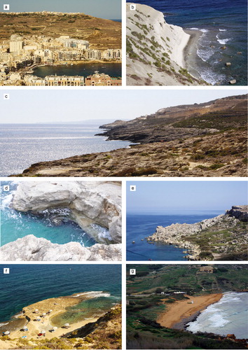
The north-eastern coast of Gozo is characterised by alternations of inlets and promontories. Upper Coralline Limestone blocks lying on marls and clays of the Blue Clay Fm. determine extensive screes (called rdum by locals) where the Blue Clay outcrops at sea level, thus covering 44% of the stretch of coast here considered. The more resistant Lower Coralline Limestone outcrop favours the development of a sloping coast (characterising 21% of the surveyed coast), between Dahlet Qorrot Bay and Ras il-Qala. Few Lower Coralline plunging cliffs (2%) are located and host roof notches with an asymmetric shape, recognised by CitationFurlani et al. (2017). Sand and mixed grain-size deposits can be found in the inner part of bays and coves constituting pocket beaches (5%). Noteworthy is the large sandy beach of Ramla Bay partly backed by dunes. Shore platforms have been identified and mapped where the more easily-erodible Globigerina Limestone Fm. outcrops at the sea level (9%). Examples can be found in the correspondence of Rdum il-Kbir promontory and on the eastern side of Marsalforn Bay. Here, a sea stack is located as a result of coast dissection due to marine erosion. Finally, the coast of Marsalforn Bay is affected mainly by anthropogenic intervention, thus 9% of the shore is constituted by the built-up coast.
Gradually sloping terraces located in shallow water, adjacent to shore platforms have been interpreted as paleo-shore platforms.
4.3. Fluvial and slope landforms due to running water
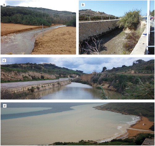
V-shaped valleys as well as flat bottom valleys are the main fluvial features in the area. The small amount of annual rainfall and the presence of discontinuities in rock masses prevent the development of a permanent hydrography. Temporary streambeds (wieden in Maltese) were identified in correspondence of some of the valleys (). These, during warm and humid stages of the Quaternary, were occupied by permanent water courses. Major wied valleys (Marsalforn and Ramla valleys) continue below sea level where channels carved the present day seafloor and have been interpreted as relict fluvial valleys bounded by palaeo-fluvial scarps. Thus, they witness the existence of a palaeo-drainage pattern produced by fluvial processes active in more humid periods characterised also by sea level lowstands. Few incisions indent the escarpment north-east Marsalforn Bay and east the quarry located at Qala. They do not seem to be linked to a wied on land, however, it is probably that they were related to a fluvial valley during a sea level lowstand. At that time, the water courses extended on the present continental shelf and reached an erosional power sufficient to start carving a valleys starting from the break of slope. Then the sea level rose and stopped the fluvial erosion so that the terminal part of the valley was not able to reach its upper course (CitationVan Heijst & Postma, 2001). The more recent ephemeral water courses led to the deposition of alluvium on the bottom of the main valleys of Marsalforn and Ramla bays. Water infiltrating through the overlaying deep-fractured and karstified limestone plateaus and water from direct rainfalls is conveyed along channels incised into impermeable clayey slopes, which have been mapped as gullies. Where these incised channels do not exceed a few tens of centimetres in depth and in width, they have been mapped as diffuse rill erosion.
Figure 4. Ramla Wied during different periods: (a) and (c) the temporary stream is full after an intense rainy period (November 2017); (b) the valley is dry (September 2017) and hosts sediments and vegetation and a succession of alluvial sediments is observable on a side of the small fluvial scarp. In frame (d) Ramla Bay (seen from the north) during a flash flood occurred on 15 November 2012; the abundance of transported sediment is noticeable.
Alluvial deposits have been identified in correspondence of the largest flat bottom valleys. Those deposits are mainly constituted by well-sorted sediments, including rounded cobbles, sand and silt.
4.4. Karst landforms
The surface of limestone plateaus is extensively characterised by small-scale karstic features ranging in size from centimetres to metres, such as diffuse solution pools, grooves and furrows. Two caves modelled by carbonate dissolution processes have been mapped in correspondence of the base of the limestone plateaus between Dahlet Qorrot Bay and Gebel Mistra promontory.
4.5. Gravity-induced slope landforms
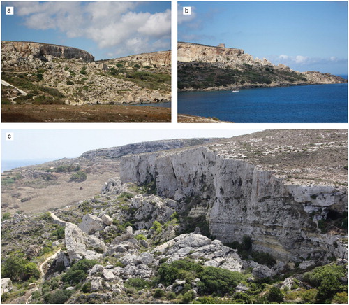
Different types of gravity-induced landforms – such as rock spreads, block slides, rock falls and earth flows/slides – widely affect the north-eastern coast of Gozo (). The role of tectonics remains significant providing a dense network of joints and fractures (CitationAlexander, 1988). Moreover, the geological setting plays a crucial influence on landslides movements. The superposition of brittle limestone plateaus over clayey terrains in large parts of the investigated area favours the fracturing of the plateau and the development of lateral spreading which tend to evolve into block sliding (CitationDevoto et al., 2012; CitationMagri, Mantovani, Pasuto, & Soldati, 2008; CitationMantovani et al., 2013; CitationPasuto & Soldati, 2013). Clayey slopes are also largely affected by shallow earth flows and earth slides (CitationDykes, 2002), while limestone cliffs also retreat due to rock falls. Block slides and earth flows/slides runout often continue below the sea level reaching ca. −20 m of depth (e.g. Gebel Mistra block slide). According to the evidence of landslide dating carried out the NW coast of Malta, it is likely that they occurred and developed in a subaerial environment during sea-level lowstands and they were successively drowned during post-glacial marine transgression (CitationSoldati, Barrows, Prampolini, & Fifield, 2017).
Figure 5. Landslides: (a) block slides (west of Dahlet Qorrot Bay); (b) earth flow and block slide (between San Blas Bay and Dahlet Qorrot Bay); (c) rock fall at the bottom of a limestone plateau and earth flow/slide affecting the underlying clayey terrain (between San Blas Bay and Dahlet Qorrot Bay).
4.6. Marine deposits
The submarine area here considered is the shallowest part of the continental shelf surrounding the Island of Gozo and reaches the maximum depth of ca. −80 m. During the last glacial cycle, the sea level progressively lowered – reaching the maximum lowstand (−130 m) during the Last Glacial Maximum – when the whole submarine area here analysed was emerged land shaped by subaerial processes. Marine processes occurred during and after the post-glacial marine transgression (CitationPrampolini et al., 2017) and have not significantly modified the landforms previously shaped in subaerial conditions. Thus, most of the landforms now observable on the seafloor are related to subaerial processes, such as fluvial incisions and landslide accumulations. The latter represent the continuation of terrestrial rock slide and earth slide/flow progressively submerged during post-glacial sea level rise.
The continental shelf results as covered by post-glacial marine sediments, mainly constituted of coarse sand and gravel.
4.7. Anthropogenic landforms
The Main Map is accompanied by a Land Cover Map including three main categories, inspired by the CORINE Land Cover classification (CitationLydon & Smith, 2014): (i) agricultural areas, (ii) artificial surfaces, (iii) natural and semi-natural areas.
In the north-eastern sector of Gozo, the principal anthropogenic activity is related to agriculture and land development. Agricultural areas are the predominant land cover type of the sector explored. It arises especially on top of the Blue Clay Formation, the softer surface where vegetation easily grows due to the presence of water and fine sediments. A substantial part of the agricultural land is set on sloping grounds which were terraced with retaining walls made of limestone rubble, many of them fallen into disrepair with a concurrent increase of soil erosion. Where active, terraced fields are the main geomorphological feature and deeply modify the landscape. They have been depicted not only in the Land Cover Map but also in the Main Map.
Built-up areas are discontinuous; they include towns, villages, recreational areas and industrial lands. Worthy of notice is the extensive urban structure at Marsalforn town and surroundings. A huge and invasive active quarry, excavating Lower Coralline Limestone, is situated in proximity of Ras il-Qala and covers a surface of about 0.134 km2, while an inactive dump site of ca. 0.043 km2 is located on the plateau south-east of Marsalforn Bay. Ramla Bay is an important tourist attraction with its reddish beach (ramla in Maltese), a protected coastal dune system and three features of archaeological interest: a Roman villa, a Fugasse and the remains of a submerged wall built by the Knights of St. John of Jerusalem during their presence on the island to protect the bay from seaborne invaders.
The remaining study area is characterised by natural and semi-natural areas where natural vegetation is well developed, except in correspondence of landslide accumulation where the vegetation cover is discontinuous. Sclerophyllous vegetation, shrubs and small evergreen trees typical of the Mediterranean climate are quite common in these areas.
5. Conclusions
This work provides the first geomorphological map of the north-eastern coast of Gozo. Special attention was devoted to mass movements recognition and mapping, identification of the types of land cover most favourable to landslides development, and classification and spatial distribution of coastal geomorphotypes of this stretch of coast. Submarine areas in shallow water were also considered in order to obtain a full picture of the landforms and processes acting along this coast. This integrated geomorphological analysis sheds light on the relationship between terrestrial landforms and their submarine continuity and on their genesis. Indeed, the presence of a submerged landscape was modelled in a formerly terrestrial environment and then drowned during the post-glacial sea level rise was highlighted.
This paper constitutes one of the few works available in the literature dealing with an integrated geomorphological analysis of a coastal area and its submarine reaches. It may also provide the basis for coastal hazard assessment and risk reduction along this touristic stretch of coast (cf. CitationPiacentini et al., 2015; CitationSoldati, Maquaire, Zezere, Piacentini, & Lissak, 2011) and geoheritage enhancement and protection (cf. CitationCoratza et al., 2012, Citation2016).
Software
The map and the layout were produced using ESRI ArcGIS and Adobe Illustrator.
Geomorphology of the north-eastern coast of Gozo (Malta, Mediterranean Sea).pdf
Download PDF (6.5 MB)Acknowledgements
The authors are grateful to Sara Biolchi, Alessandro Chelli, Alessandro Cuoghi, Stefano Devoto, Kevin Graff, Federico Lolli, Matteo Mantovani, Giuseppe Mastronuzzi, Luca Pisani, Brian Restall, Thomas Roulland and Michael Saliba for their helpful participation in the geomorphological surveys during the ‘Training Course on Geomorphological Mapping in Coastal Areas’ organised under the framework of the EUR-OPA Major Hazards Agreement of the Council of Europe in collaboration with the Euro-Mediterranean Centre on Insular Coastal Dynamics (ICoD) and the European Centre on Geomorphological Hazards (CERG). They are also grateful to the Malta Planning Authority (MPA) for providing bathymetric and LiDAR data, aerial photos and marine data.
Disclosure statement
No potential conflict of interest was reported by the authors.
Additional information
Funding
Related Research Data
References
- Alexander, D. (1988). A review of the physical geography of Malta and its significance for tectonic geomorphology. Quaternary Science Reviews, 7(1), 41–53. doi: 10.1016/0277-3791(88)90092-3
- Baldassini, N., & Di Stefano, A. (2017). Stratigraphic features of the Maltese archipelago: A synthesis. Natural Hazards, 86(2), 203–231. doi: 10.1007/s11069-016-2334-9
- Benjamin, J., Rovere, A., Fontana, A., Furlani, S., Vacchi, M., Inglis, R., … Gehrels, R. (2017). Late quaternary sea-level changes and early human societies in the central and eastern Mediterranean basin: An interdisciplinary review. Quaternary International, 449, 29–57. doi: 10.1016/j.quaint.2017.06.025
- Biolchi, S., Furlani, S., Devoto, S., Gauci, R., Castaldini, D., & Soldati, M. (2016). Geomorphological identification, classification and spatial distribution of coastal landforms of Malta (Mediterranean Sea). Journal of Maps, 12(1), 87–99. doi: 10.1080/17445647.2014.984001
- Coratza, P., Galve, J. P., Soldati, M., & Tonelli, C. (2012). Recognition and assessment of sinkholes as geosites: Lessons from the Island of Gozo (Malta). Quaestiones Geographicae, 31(1), 22–35. doi: 10.2478/v10117-012-0006-8
- Coratza, P., Gauci, R., Schembri, J., Soldati, M., & Tonelli, C. (2016). Bridging natural and cultural values of sites with outstanding scenery: Evidence from Gozo, Maltese Islands. Geoheritage, 8, 91–103. doi: 10.1007/s12371-015-0167-7
- Devoto, S., Biolchi, S., Bruschi, V. M., Furlani, S., Mantovani, M., Piacentini, D., & Soldati, M. (2012). Geomorphological map of the NW coast of the Island of Malta (Mediterranean Sea). Journal of Maps, 8(1), 33–40. doi: 10.1080/17445647.2012.668425
- Dykes, A. P. (2002). Mass movements and conservation management in Malta. Journal of Environmental Management, 66, 77–89. doi: 10.1006/jema.2002.0577
- Foglini, F., Prampolini, M., Micallef, A., Angeletti, L., Vandelli, V., Deidun, A., & Taviani, M. (2016). Late quaternary coastal landscape morphology and evolution of the Maltese Islands (Mediterranean Sea) reconstructed from high-resolution seafloor data. In J. Harff, G. Bailey, & L. Lüth (Eds.), Geology and archaeology: Submerged landscapes of the continental shelf (Vol. 411, Issue 1, pp. 77–95). London: Geological Society, Special Publication. doi: 10.1144/SP411.12
- Furlani, S., Antonioli, F., Biolchi, S., Gambin, T., Gauci, R., Lo Presti, V., … Sulli, A. (2013). Holocene sea level change in Malta. Quaternary International, 288, 146–157. doi: 10.1016/j.quaint.2012.02.038
- Furlani, S., Antonioli, F., Gambin, T., Gauci, R., Ninfo, A., Zavagno, E., … Cucchi, F. (2017). Marine notches in the Maltese islands (central Mediterranean Sea). Quaternary International, 439, 158–168. doi: 10.1016/j.quaint.2016.03.004
- Galve, J. P., Tonelli, C., Gutiérrez, F., Lugli, S., Vescogni, A., & Soldati, M. (2015). New insights into the genesis of the Miocene collapse structures of the island of Gozo (Malta, central Mediterranean Sea). Journal of the Geological Society, 172, 336–348. doi: 10.1144/jgs2014-074
- Gardiner, W., Grasso, M., & Sedgeley, D. (1995). Plio-Pleistocene fault movement as evidence for mega-block kinematics within the Hyblean – Malta Plateau, Central Mediterranean. Journal of Geodynamics, 19, 35–51. doi: 10.1016/0264-3707(94)00006-9
- Gruppo di Lavoro per la Cartografia Geomorfologica. (1994). Carta geomorfologica d’Italia – 1:50.000, guida al rilevamento. Servizio Geologico Nazionale, Quaderni Serie III, 4, 1–42.
- Jongsma, D., van Hinte, J. E., & Woodside, J. M. (1985). Geologic structure and neotectonics of the North African Continental Margin south of Sicily. Marine and Petroleum Geology, 2(2), 156–179. doi: 10.1016/0264-8172(85)90005-4
- Lambeck, K., Antonioli, F., Anzidei, M., Ferranti, L., Leoni, G., Scicchitano, G., & Silenzi, S. (2011). Sea level change along the Italian coast during the Holocene and projections for the future. Quaternary International, 232, 250–257. doi: 10.1016/j.quaint.2010.04.026
- Lambeck, K., Rouby, H., Purcell, A., Sun, Y., & Sambridge, M. (2014). Sea level and global ice volumes from the last glacial maximum to the Holocene. Proceedings of the National Academy of Sciences, 111(43), 15296–15303. doi: 10.1073/pnas.1411762111
- Lydon, K., & Smith, G. (2014). CORINE landcover 2012 Ireland final report. Wexford: Environmental Protection Agency, Johnstown Castle. 55 pp. Retrieved from http://www.epa.ie/pubs/data/corinedata/CLC2012_IE_Final_Report.pdf
- Magri, O. (2006). A geological and geomorphological review of the Maltese islands with special reference to the coastal zone. Territoris, 6, 7–26.
- Magri, O., Mantovani, M., Pasuto, A., & Soldati, M. (2008). Geomorphological investigation and monitoring of lateral spreading along the north-west coast of Malta. Geografia Fisica e Dinamica Quaternaria, 31(2), 171–180.
- Mantovani, M., Devoto, S., Forte, E., Mocnik, A., Pasuto, A., Piacentini, D., & Soldati, M. (2013). A multidisciplinary approach for rock spreading and block sliding investigation in the north-western coast of Malta. Landslides, 10(5), 611–622. doi: 10.1007/s10346-012-0347-3
- Mastronuzzi, G., Aringoli, D., Aucelli, P. P. C., Baldassarre, M. A., Bellotti, P., Bini, M., & Valente, A. (2017). The geomorphological map of the Italian coast: From a descriptive to a morphodynamic approach. Geografia Fisica e Dinamica Quaternaria, 40, 161–195. doi: 10.4461/ GFDQ 2017.40.11
- Micallef, A., Foglini, F., Le Bas, T., Angeletti, L., Maselli, V., Pasuto, A., & Taviani, M. (2013). The submerged paleolandscape of the Maltese islands: Morphology, evolution and relation to quaternary environmental change. Marine Geology, 335, 129–147. doi: 10.1016/j.margeo.2012.10.017
- Mottershead, D., Bray, M., Soar, P., & Farres, P. J. (2014). Extreme wave events in the central Mediterranean: Geomorphic evidence of tsunami on the Maltese islands. Zeitschrift für Geomorphologie, 58(3), 385–411. doi: 10.1127/0372-8854/2014/0129
- Oil Exploration Directorate. (1993). Geological map of the Maltese islands. Valletta: Office of the Prime Minister.
- Paskoff, R., & Sanlaville, P. (1978). Observations geomorphologiques sur le cotes de l’Archipel Maltaise. Zeitschrift für Geomorphologie, 22(3), 310–328.
- Pasuto, A., & Soldati, M. (2013). Lateral spreading. In J. F. Shroder (Ed.), Treatise on geomorphology (Vol. 7, pp. 239–248). San Diego, CA: Academic Press.
- Pedley, H. M., Clarke, M. H., & Galea, P. (2002). Limestone isles in a crystal Sea: The geology of the Maltese Islands. San Gwann (Malta): Publisher Enterprises Group.
- Piacentini, D., Devoto, S., Mantovani, M., Pasuto, A., Prampolini, M., & Soldati, M. (2015). Landslide susceptibility modeling assisted by Persistent Scatterers Interferometry (PSI): An example from the northwestern coast of Malta. Natural Hazards, 78, 681–697. doi: 10.1007/s11069-015-1740-8
- Prampolini, M., Foglini, F., Biolchi, S., Devoto, S., Angelini, S., & Soldati, M. (2017). Geomorphological mapping of terrestrial and marine areas, Northern Malta and Comino (central Mediterranean Sea). Journal of Maps, 13(2), 457–469. doi: 10.1080/17445647.2017.1327507
- Said, G., & Schembri, J. A. (2010). Malta. In E. C. F. Bird (Ed.), Encyclopedia of the world's coastal landforms (pp. 751–759). Dordrecht: Springer Science & Business Media B.V. doi: 10.1007/978-1-4020-8639-7
- Soldati, M., Barrows, T. T., Prampolini, M., & Fifield, K. L. (2017). Cosmogenic exposure dating constraints for coastal landslide evolution on the Island of Malta (Mediterranean Sea). Journal of Coastal Conservation, 1–14. doi: 10.1007/s11852-017-0551-3
- Soldati, M., Maquaire, O., Zezere, J. L., Piacentini, D., & Lissak, C. (2011). Coastline at risk: Methods for multi-hazard assessment. Journal of Coastal Research, 61, 335–339, Management of Recreational Resources. doi: 10.2112/SI61-001.34
- Soldati, M., Tonelli, C., & Galve, J. P. (2013). Geomorphological evolution of palaeosinkhole features in the Maltese archipelago (central Mediterranean Sea). Geografia Fisica e Dinamica Quaternaria, 36, 189–198. doi: 10.4461/GFDQ.2013.36.16
- Van Heijst, M. W. I. M., & Postma, G. (2001). Fluvial response to sea-level changes: A quantitative analogue, experimental approach. Basin Research, 13(3), 269–292. doi: 10.1046/j.1365-2117.2001.00149.x
- Web sites
- Malta International Airport Meteorological Office. Retrieved from https://www.maltairport.com/weather/
- MPA. 2016. https://pa.org.mt/