
ABSTRACT
We present the geological map at 1:25,000 scale of the Plio-Quaternary Paganica-San Demetrio-Castelnuovo Basin corresponding to the epicentral area of the 6 April 2009 Mw: 6.29 L’Aquila earthquake. The map focuses on the relationships between the active tectonics and the Plio-Quaternary deposits and on the early evolution of this continental basin. Fine-scale geological field surveys, coupled with paleontological data, facies analyses, well logs and geophysical data interpretation, allowed to better understand the stratigraphy and to review the previously described stratigraphical units, resulting in the definition of eight synthems, spanning from late Piacenzian to Holocene. More precisely, the occurrence of a Caspiocypris species flock (ostracods) at the base of the sedimentary infill of the basin formed by a lacustrine system, suggests that the onset of deposition started in the late Piacenzian. The lacustrine system disappeared around the Gelasian/Calabrian transition, while the subsequent evolution of the sedimentary basin was characterized by the presence of fluvial and alluvial fan systems progressively entrenched into the lake deposits.
The results of the above-mentioned activities are summarized in the attached geological map, where the Plio-Quaternary synthems and the active normal faults accountable for the significant seismicity were highlighted.
1. Introduction
The Paganica-San Demetrio-Castelnuovo Basin (PSCB) represents the eastern portion of the intermontane L’Aquila Basin, located in the central Apennines along the Aterno River Valley, between the Gran Sasso Range, to the north, and the Ocre Mts., to the south. PSCB extends over more than 130 km2, from the Paganica village, to the Campana gorge (CitationGiaccio et al., 2012). It is a NW-SE trending Plio-Quaternary graben characterized by a rectilinear south-western border and a more articulated north-eastern one, expression of the main boundary normal faults. The Paganica-San Demetrio Fault System, accountable for the 6 April 2009 earthquake (CitationEMERGEO Working Group, 2010; CitationScognamiglio et al., 2010), and the Barisciano-San Pio Fault bound the PSCB to the NE, while the Bazzano-Fossa Fault bounds it to the SW (CitationBlumetti, Guerrieri, & Vittori, 2013; CitationFalcucci et al., 2011, Citation2015; CitationGalli, Giaccio, Messina, Peronace, & Zuppi, 2011; CitationGiaccio et al., 2012; CitationSanto et al., 2014; CitationStorti et al., 2013).
The basin infill is composed by Plio-Quaternary continental deposits, unconformably overlaying the pre- and syn-orogenic bedrock, composed by Meso-Cenozoic platform to slope and ramp carbonate successions and Miocene terrigenous turbidites (CitationCosentino, Cipollari, Marsili, & Scrocca, 2010). Starting from CitationBosi and Bertini (1970), many authors suggested different evolutionary schemes for the PSCB, resulting in the existence of contrasting continental stratigraphies (CitationBertini & Bosi, 1993; CitationBosi, 1989; CitationCentamore, Crescenti, & Dramis, 2006; CitationGalli, Giaccio, & Messina, 2010; CitationGiaccio et al., 2012; CitationPucci et al., 2015).
Comprehensive geological field surveys, coupled with paleontological data, facies analyses, well logs and geophysical data interpretation, allowed us to fine-tune and to review the PSCB stratigraphy. This multidisciplinary approach, showing new stratigraphical and paleontological data essential to understand the early evolutionary stage of the PSCB, brought to the identification of eight synthems dated from late Piacenzian to Holocene. The attached geological Main Map shows this updated stratigraphy and is mainly focused on the relationships between the Plio-Quaternary deposits and the active tectonic setting (CitationCosentino et al., 2017; CitationNocentini, 2016).
2. Methods
The geological map was produced combining earlier maps with new field surveys, improved by a high-resolution LiDAR DTM (cell-size: 1 m × 1 m).
The Main Map was realized at 1:25,000 scale by using the CTR topographic maps of Abruzzo Region, while fieldwork mapping was done at 1:5000 scale. The Meso-Cenozoic formations are mapped considering their paleogeographic domains according to the lithostratigraphic units of L’Aquila (Sheet 359) and Torre de’ Passeri (Sheet 360) geological maps (CitationAPAT, 2005a, Citation2005b; CitationCentamore et al., 2006). The Plio-Quaternary continental deposits were defined as UBSU, combining our synthems with that previously defined in the literature (e.g. CitationBertini & Bosi, 1993; CitationGiaccio et al., 2012).
Field works were integrated with paleontological analysis to provide information about depositional environment, age, past climatic conditions and to correlate the Plio-Quaternary deposits throughout the basin.
To define the subsurface geometry of the basin and the stratigraphy of the continental infill, a comprehensive review of the available well logs was carried out, considering also the geophysical data from literature (CitationAmoroso et al., 2010; CitationCivico et al., 2017; CitationDel Monaco, Tallini, De Rose, & Durante, 2013; CitationGruppo di Lavoro MS-AQ, 2010; CitationImprota et al., 2012; CitationMacrì et al., 2016; CitationPorreca et al., 2016; CitationPucci et al., 2015).
3. Stratigraphy of the Paganica-San Demetrio-Castelnuovo Basin
3.1. San Demetrio-Colle Cantaro Synthem
The first deposition phase within the PSCB correspond to the formation of the San Demetrio-Colle Cantaro Synthem, largely fitting with the Lower PSCB Synthem of CitationGiaccio et al. (2012), from which it differs for the age and some stratigraphic interpretations. This synthem is well preserved in the SE sector of the PSCB, while in the western part, it outcrops discontinuously. Due to the presence of a minor unconformity in the upper part of the synthem, it is split into two sub-synthems: the Castelnuovo Sub-Synthem, including several formations deposited in different environments of a lacustrine system, and the Valle dell’Inferno Sub-Synthem, related to a fluvial environment. The whole San Demetrio-Colle Cantaro Synthem is bounded by a flat surface lying at 850 m a.s.l., the Valle Daria surface, partly representing the depositional top of the fluvial system and locally connected to some erosional surfaces carved into the Meso-Cenozoic bedrock (CitationBertini & Bosi, 1993).
3.1.1. Castelnuovo sub-Synthem
The Castelnuovo Sub-Synthem is composed by the San Nicandro Fm. (SNF), Valle Orsa Fm. (VOF), Madonna della Neve Fm. (MNF) and Valle Valiano Fm. (VVF) which are laterally interfingered each other.
The basal unconformity of the Castelnuovo Sub-Synthem is directly set onto the Meso-Cenozoic bedrock, while its upper boundary is represented by a discontinuous erosional surface carved mainly into the VOF and, locally, into the SNF.
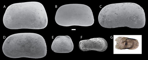
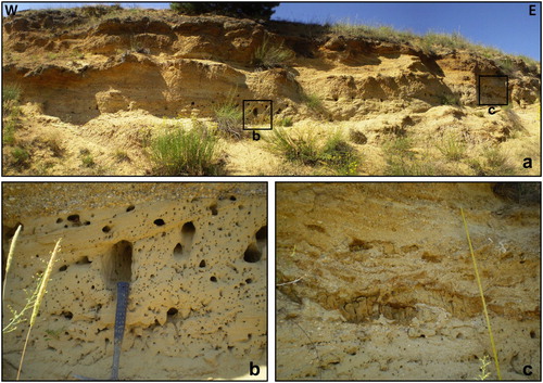
The oldest deposits of this synthem can be ascribed to the SNF, which consists of whitish and greyish laminated calcareous silts grading upward to white sandy silts (CitationBosi & Bertini, 1970). In the upper portion of the SNF slumping structures and a 7–10 cm-thick blackish tephra layer were found close to Castelnuovo village (). The SNF represents the distal deposition of a large lake settled in the depocentral area of the PSCB, as evidenced by the presence of freshwater ostracods, sponge spicules and gastropods (CitationSpadi, Gliozzi, Cosentino, & Nocentini, 2016). The peculiar ostracod fauna recovered in the Castelnuovo Sub-Synthem (), points to a revision of the age of the lake deposits. The occurrence of Caspiocypris spp. in the SNF constrains the San Demetrio-Colle Cantaro Synthem to the late Piacenzian-Gelasian (CitationSpadi et al., 2016).
Figure 1. San Nicandro Fm. at Castelnuovo village. (a) calcareous silts of the San Nicandro Fm. with interlayered lenses of gravel (G); the black square refers to the area showed in figure b; (b) slumping sedimentary structure within the San Nicandro Fm.; (c) detail of the rhythmic alternation of the calcareous silts and silty sand of the San Nicandro Fm.; (d) detail of the blackish tephra horizon; (e) laminated whitish calcareous silts of the San Nicandro Fm. with reddish and blackish clayey-silts and silty sand layers cut by NW-SE oriented normal faults.
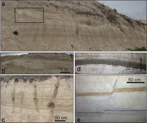
Figure 2. Ostracod assemblage from San Nicandro Fm. (a) Caspiocypris amiterni; (b) Caspiocypris bosii; (c) Caspiocypris nicandroi; (d) Caspiocypris vestinae; (e) Cypria bikeratia; (f) Amnicythere ex gr. stanchevae; (g) Paralimnocythere cf. dictyonalis (CitationSpadi et al., 2016). White bar corresponds to 0.1 mm.
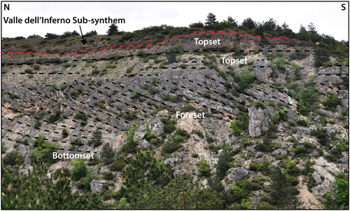
The SNF pass laterally to coarse grain deposits of a Gilbert-type delta system (VOF) (). VOF is characterized by lithological and sedimentological variations, reflecting different depositional environment within the delta system, resulting in the formation of bottomset, foreset and topset. Bottomset beds are formed by meter-thick layers of yellowish fine-medium sands and silty sands, with horizontal lamination, deposited by high-energy bottom currents. Foreset beds, arranged to form the delta slope, are composed by 1 m thick steeply dipping (20–30°) beds of well-sorted and well-rounded polygenic calcareous gravels and conglomerates. They are generally clast-supported, with a coarse sandy matrix and rare thin whitish calcareous silt. Foreset beds generally dip toward S-SE, downlapping on the bottomset and/or the lacustrine deposit, indicating a progradation from N or NW of the delta into the lake (CitationGiaccio et al., 2012). Topset beds are made of well-rounded, poorly sorted polygenic calcareous coarse gravels and conglomerates in a sandy silty matrix, characterized by sub-horizontal layers with massive or rarely planar cross-stratified bedding.
Figure 3. Panoramic view of the Gylbert-type delta system (Valle Orsa Fm.) of the San Nicandro Paleolake along the Inferno Valley.
Toward the NE slopes of the PSCB, the SNF and VOF are laterally interfingered with coarser sediments, belonging to the MNF and VVF.
The MNF extensively outcrops at the base of the mountains slope. It consists in an alternation of whitish calcareous lacustrine silt layers and poorly sorted, angular to sub-angular, matrix-supported calcareous breccias in massive beds. This alternation represents the interaction between lacustrine sedimentation and slope-related processes at the lake margin, with the occasional arrive of density currents into the lake.
The VVF occupies the NE slopes of the PSCB, where it generally interposes between the Meso-Cenozoic bedrock, on which it lies, and the others formation of the Castelnuovo Sub-Synthem, to which it laterally passes. The VVF is made by well-stratified and well-sorted, trough or planar cross-bedded, alluvial fan conglomerates, laterally passing to heterometric, angular calcareous breccias, both stratified and massive, clast-supported or with abundant whitish calcareous silty matrix. The characteristics of the VVF suggest that it represents the lake palaeo-margins, characterized by steep coastlines crosscut by transverse water bodies forming alluvial fans.
3.1.2. Valle dell’Inferno sub-Synthem
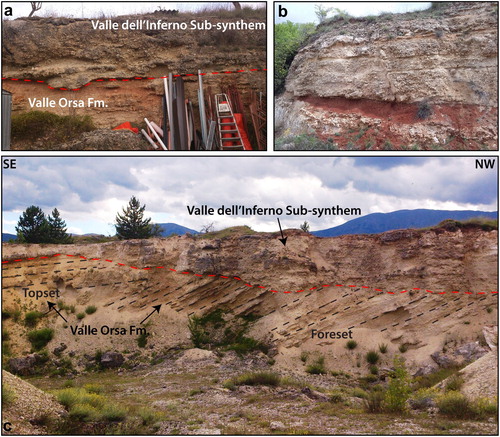
In the eastern sectors of the PSCB, the topset and foreset beds of the VOF are eroded and unconformably overlaid by the Valle dell’Inferno Sub-synthem, represented by the Valle dell’Inferno Fm. (VIF). The VIF is composed of sub-horizontal beds of well-rounded, clast-supported conglomerates, with coarse to medium calcareous pebbles in a sandy matrix (). Beds are 0.5 m up to 5 m thick and are characterized by trough and planar cross-bedding. Often pink massive calcareous silty levels are preserved at the top of the channel. The VIF belongs to a gravel-bed braided fluvial system developed, subsequently to a local erosive phase, above the Castelnuovo Sub-synthem, as testified by the basal unconformity of the Valle dell’Inferno Sub-synthem, marked by the partial erosion of the previous deposits and/or by the occasional presence of a paleosol ().
Figure 4. Valle dell’Inferno Sub-synthem. (a) Unconformity between the topset of the Valle Orsa Fm., showing incipient pedogenesis, and the planar cross-bedded conglomerates of the Valle dell’Inferno Sub-synthem (i.e. Poggio Picenze); (b) Detail of the paleosol at the base of the Valle dell’Inferno Sub-synthem (i.e. Petogna); (c) Angular unconformity of the Valle dell’Inferno Sub-synthem carved into both foreset and topset of the Valle Orsa Fm. The flat top is the Valle Daria surface (855 m asl) (i.e. Cava Prosciutto).
3.2. Madonna della Strada Synthem
The Madonna della Strada Synthem includes the Madonna della Strada Fm. (MDS) and the San Marco Fm. (SMF), which are laterally interlayered.
Laminated to massive greyish clayey silts and yellowish sand bedforms referable to the MDS outcrop to the W of the Bazzano-Monticchio ridge, in the L’Aquila-Scoppito Basin (ASB) (CitationNocentini et al., 2017), while in the PSCB, no outcrop of these deposits is reported. Similarly, huge thickness of MDS were drilled in the ASB, whereas in the PSCB, only some boreholes show a few meters of sediments referable to the MDS (CitationAmoroso et al., 2010; CitationMacrì et al., 2016; CitationPorreca et al., 2016). In both cases, the Madonna della Strada Synthem was found at lower elevations with respect to the top of the San Demetrio-Colle Cantaro Synthem, providing the evidence of a strong uplift phase between the sedimentation of these two synthems (CitationCosentino et al., 2017).
Well-cemented, massive to well-stratified, heterometric calcareous breccia with a pinkish matrix crops out occasionally on the north-eastern slopes of the basin, laying unconformably onto either the Mezo-Cenozoic bedrock or the VVF (CitationBertini & Bosi, 1993; CitationBosi & Messina, 1990; CitationD’Agostino, Funiciello, Speranza, & Tozzi, 1994; CitationD’Agostino, Speranza, & Funiciello, 1997). Considering stratigraphical and lithological similarities, these deposits were related to the SMF and referred to the Calabrian (CitationMessina, Moro, & Speranza, 2001).
3.3. Fosso di Genzano Synthem
Deposits previously referred to the Catignano Synthem (CitationCentamore et al., 2006), the San Mauro and San Giovanni cycles in CitationBertini and Bosi (1993) and to the Upper PSCB Synthem by CitationGiaccio et al. (2012) were grouped together into the Fosso di Genzano Synthem (FGS) (CitationCentamore & Dramis, 2010). This synthem is deeply embedded into the previous ones and a reddish paleosol locally marks the basal unconformity (CitationGalli et al., 2010; CitationGiaccio et al., 2012).
It is formed by coarse to medium, well-sorted, clast-supported, sheet-type gravel beds, with massive or horizontal bedding, capped by thin layers of laminated to massive sandy silts (). These deposits grade upward into medium to fine, well-rounded calcareous gravels with a coarse sandy matrix, showing planar and trough cross-bedding. The FGS laterally passes into coarse to fine sand with ripples, alternating with laminated grey clayey silt, which can be interpreted as overbank sediments.
Figure 5. Fosso di Genzano Synthem (FGS). (a) panoramic view of the alternating gravel and sand beds of FGS (i.e. Il Crocifisso quarry); (b) close view of a trough-cross-stratified coarse sand layer; (c) massive sandy silt of an abandonment channel infill.
The FGS pertain to gravel-bed braided, sometimes wandering, fluvial systems associated with lateral alluvial fans.
Several tephra layers, with large crystals of biotite, pyroxene, feldspar and very small pumices, are present in the lower and middle portion of the FGS. Different authors relate these tephra horizons to the lower Middle Pleistocene activity of the Roman Comagmatic Province (CitationCentamore & Dramis, 2010; CitationGalli et al., 2010; CitationGiaccio et al., 2012; CitationGiaccio et al., 2013) In CitationGiaccio et al. (2012), one of this tephra is dated by Ar/Ar method at ca. 367 ka, confirming its attribution to the Villa Senni eruption proposed in CitationGalli et al. (2010) by geochemical fingerprinting and allowing to refer the FGS to the lower part of Middle Pleistocene.
3.4. Colle Macchione-L’Aquila Synthem
The Colle Macchione-L’Aquila Synthem (CMA) crops out only in the NW part of the basin and comprises deposits formerly ascribed to the Brecce dell’Aquila Auct., the Mégabrèches (CitationBlumetti, Cavinato, & Tallini, 1996; CitationDemangeot, 1965) and to the upper part of the Aielli-Pescina Synthem (CitationCentamore et al., 2006). It consists of calcareous breccias and megabreccias, in a whitish calcareous silty matrix. Clasts are extremely heterometric, poorly organized and angular to sub-angular in shape. They include both clast- and matrix-supported breccias, generally massive but sometimes also stratified, usually well-cemented.
The base of the CMA is highly irregular and erosive, characterized by scooped or channelized surfaces deeply embedded into the older sediments, frequently deformed by the breccia emplacement. These characteristics of the CMA point to rock avalanche and debris-flow processes (CitationEsposito, Scarascia Mugnozza, Tallini, & Della Seta, 2014).
The age of the CMA is not well constrained, although the breccias are generally referred to a Middle Pleistocene age (CitationBosi, Galadini, Giaccio, Messina, & Sposato, 2003; CitationDemangeot, 1965). A late Middle Pleistocene age is supported by the stratigraphy of the Colle Macchione ridge, (CitationCosentino et al., 2017; CitationNocentini et al., 2017).
3.5. Fosso Vetoio Synthem
The Fosso Vetoio Synthem (FVS) forms the first order of Late Pleistocene fluvial terraces (T1), represented only by small isolated remnants of an erosive flat surface carved onto the FGS, with few or no deposits, preserved between S. Eusanio Forconese and Villa S. Angelo, which were related to this synthem based on geomorphological correlation. The top of that synthem shows sub-horizontal surfaces, interpreted as erosive fluvial terraces, lying at elevations between 600–590 m a.s.l., 30–40 m above the Aterno R. thalweg.
Considering the morpho-stratigraphical relationships with the other synthems, an early Late Pleistocene age is suggested for the FVS (CitationCosentino et al., 2017; CitationNocentini et al., 2017).
3.6. Campo di Pile Synthem
The Campo di Pile Synthem is composed by fluvial/alluvial fan (CPF) and slope-derived (CPB) deposits, which are embedded into the FVS and are carved into both the older continental deposits and the pre-Pliocene bedrock.
This synthem essentially matches the Valle Majelama Synthem (CitationCentamore et al., 2006; CitationCentamore & Dramis, 2010), the Paganica 2a Unit (CitationGalli et al., 2010), the upper part of the Late PSCB Synthem (CitationGiaccio et al., 2012), the Barisciano Pedocomplex (CitationColtorti & Pieruccini, 2006) and the Ancient alluvial and colluvial deposits in CitationBertini and Bosi (1993).
Slope deposits (CPB) consist of poorly cemented and stratified carbonate gravels, both matrix- and clast-supported, occasionally open-work, showing slope-parallel bedding with dipping decreasing from proximal to distal areas. Clasts are angular to sub-angular in shape with medium grain-size.
Fluvial deposits (CPF) of the Campo di Pile Synthem are scanty in the PSCB. They are usually less than 5 m thick and made of medium to coarse, poorly sorted, sub to well-rounded, clast-supported gravel with sandy matrix. These sediments pertain to an eastward draining wandering-braided river system, responsible for the formation of the second-order fluvial terrace (T2) with a well-preserved flat top only at Villa S. Angelo. Here, the T2 is carved into the FGS and lies at 15–20 m above the Aterno River.
Alluvial fan deposits (CPF) are present at the outlet of the main tributaries of the Aterno River and compose the gently sloping landforms between San Gregorio and San Demetrio ne’ Vestini (CitationBlumetti et al., 2013). Other remnants of alluvial fans are also present at higher elevation, close to the north-eastern border of the basin. Alluvial fans are often incised and many of them are characterized by the absence of an active drainage. Their top surface is suspended at different elevations above the present-day base level, with a minimum elevation of 5 m in the hangingwall of the Paganica Fault. Locally, blackish paleosols and pedogenic horizons, containing abundant organic matter and calcic horizons (Bk), are present at the base and within these deposits. These paleosols can be classified as Chernozem and they match with those reported above the PAG-3 Unit by CitationGalli et al. (2010) and with the Barisciano Pedocomplex (CitationColtorti & Pieruccini, 2006), dated to the Late Pleistocene.
Considering these constrains, the 14C dating and the founding of Mousterian lithic industry within the CPF gravels in the ASB (CitationCosentino et al., 2017; CitationNocentini et al., 2017), this synthem is referred to the upper part of the Late Pleistocene.
3.7. Ponte Peschio Synthem
In very few localities, isolated remnants of an erosive surface are embedded between the Campo di Pile Synthem and the basin floor, forming the Ponte Peschio Synthem (PPS). It constitutes the third-order fluvial terrace (T3), laying at 5–7 m above the Aterno R., and frequently has no related deposits. The PPS represents a minor erosional phase occurred after the formation of the upper Late Pleistocene Campo di Pile Synthem, probably referable to tectonic uplift coupled with the LGM climate. Thus, as well as in the ASB, the PPS can be related to MIS 2, so to the final part of the Late Pleistocene (<29 ka) (CitationNocentini et al., 2017).
3.8. Aterno Synthem
The Aterno Synthem includes the Holocene fluvial, colluvial, scree deposits and landslides related to the erosional and depositional processes still active in the PSCB basin. These deposits are embedded and unconformably overlain both the older synthems and the Meso-Cenozoic bedrock.
4. Subsurface data
4.1. Well logs analysis and thickness of the Plio-Quaternary cover
In the PSCB, boreholes are gathered in urbanized areas, only a few of them exceed 30 m depth and hardly ever they drilled the whole Plio-Quaternary.
Apart from some boreholes drilled in the western part of the basin (S57, S59, S70, S80, S82), the San Demetrio-Colle Cantaro Synthem was always found at the base of the basin infill. This synthem shows thickness usually higher than 30 m, with its maximum in the SE sector, where it exceeds more than 100 m (S97). The San Demetrio-Colle Cantaro Synthem is extensively displaced by tectonic activity, as testified by the deposits entrenched beneath the Aterno Valley floor (S69, S72, S76) and those uplifted in the Castelnuovo-Civitaretenga plateau (S90, S91, S97, S106).
Only the boreholes drilled within the Aterno R. floodplain contain sediments, a few meters thick, that could be related to the MDS (S69, S72, S86, S100, S101, S103). On the contrary, to the west of the Bazzano-Monticchio ridge, well logs mark the existence of a deep depocentre, with a maximum thickness of the MDS from well S80, which drilled 215 m of fine-grained deposits (CitationMacrì et al., 2016; CitationPorreca et al., 2016).
Gravels and sands belonging to the FGS are present in all the wells of the PSCB, except for those located at the footwall of the Paganica-San Demetrio fault system (S91, S97, S106). FGS shows thickness of about 20–30 m, with a maximum of 40 m in correspondence of the Raiale alluvial fan (S68, S69, S72).
Above the FGS, coarse-grained deposits referable to CMA were intercepted in wells S66 and S80, which were drilled close to L’Aquila Hill, confirming field observations.
Due to both their thin thickness and the similarities between their deposits, the FVS and CPB or CPF were distinguished considering geomorphological indications, such as fluvial terrace (S87, S100) or alluvial fan (e.g. S66, S68, S76, S104) orders.
The thickness of the continental infill, reported in the map, was estimated through borehole logs and geophysical investigations (ERT, TDEM; seismic reflection profile, and HVSR technique: CitationCivico et al., 2017; CitationImprota et al., 2012; CitationPucci et al., 2015). The maximum thickness (around 600 m), inferred from a deep ERT, is placed in the central area of the PSCB corresponding to a wide negative gravimetric anomaly, while the deepest borehole intercept the bedrock at 190 m b.g.l.
The thickness of SNF, estimated both from borehole logs and ERT, ranges quite steady around 100–150 m through the PSCB.
5. Conclusions
The results of the Plio-Quaternary geology of the PSCB are summarized in the accompanying geological Main Map (1:25,000 scale), where the active normal faults accountable for the significant seismicity of the area are also shown. shows the relationships between the stratigraphy defined in this work and those reported in previous works.
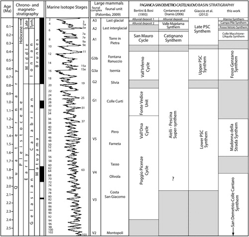
Figure 6. Plio-Quaternary stratigraphy of the PSCB according to different authors. Question mark indicates a possible extension to the Gelasian of the Aielli-Pescina Super-Synthem in CitationCentamore et al. (2006). Black arrow indicates a real extension to the late Piacenzian of the San Demetrio-Colle Cantaro Synthem (CitationCosentino et al., 2017; CitationSpadi et al., 2016). The Ponte Peschio Synthem is not reported between the Campo di Pile and the Aterno synthems to avoid overlapping.
Important results for revising both the starting age of the L’Aquila Basin and the correlation among the basin fills come from the ostracod assemblages of the lacustrine facies (Castelnuovo Sub-Synthem) of the San Demetrio-Colle Cantaro Synthem, which are characterized by a Caspiocypris species flock (CitationCosentino et al., 2017; CitationSpadi et al., 2016). These assemblages suggest a correlation between the lacustrine deposits of the Castelnuovo Sub-Synthem (San Demetrio-Colle Cantaro Synthem) and those of the Fosso Bianco Formation (Tiberino Basin), which also contains a Caspiocypris species flock (CitationBasilici, 1997; CitationSpadi, Gliozzi, & Medici, 2017). This correlation allows to constrain the first phase of the PSCB basin infill to the late Piacenzian-Gelasian. During this stage, the PSCB was filled by lacustrine and delta deposits giving way to transitional deposits and carbonate slope breccias toward the lake margins (Castelnuovo Sub-Synthem). Finally, in the Gelasian, the lacustrine environment disappears with the establishment of a braided fluvial environment (Valle dell’Inferno Sub-Synthem) that closes the initial phase of deposition (San Demetrio-Colle Cantaro Synthem).
A strong uplift phase occurred in the PSCB at the Gelasian/Calabrian transition as highlighted by the deep entrenching of the MDS into the top surface of the San Demetrio-Colle Cantaro Synthem (Valle Daria surface). After this stage, the PSCBB was occupied by a meandering fluvial system belonging to the MDS, well-constrained to the Calabrian and characterized by a completely different ostracod assemblage, typical of wide floodplain and swampy areas (CitationCosentino et al., 2017; CitationNocentini et al., 2017; CitationSpadi et al., 2016, Citation2017). The absence or reduced thickness of the MDS in the PSCB could indicate that the Campana threshold was open, justifying the strong erosion underwent by this part of the L’Aquila Basin during this stage.
Since the early Middle Pleistocene, a braided river with several lateral alluvial fan systems flowed through both the PSCB and ASB, as testified by the presence of the Fosso di Genzano Synthem in both the basin, suggesting that they were definitively connected and no threshold interrupted the ‘paleo-Aterno’ fluvial system.
During the Late Pleistocene, the progressive entrenching of braided fluvial systems characterized the evolution of the PSCB, forming the Fosso Vetoio, Campo di Pile, and Ponte Peschio synthems, with their relative fluvial terraces (T1, T2 and T3).
Software
Boreholes, geophysical and field data were arranged in a GIS database together with LiDAR, orthophotos, DEM and previous maps. LiDAR data were processed with QGIS to get the high-resolution DTM. The geological map was elaborated using QGIS, while geological cross-sections, schemes, layout and final editing were produced with Adobe Illustrator®.
Supplemental Material (PSCB Map)
Download PDF (59.3 MB)Acknowledgements
Digital cartography by courtesy of Abruzzo Region. The airborne LiDAR survey used for the map was available by courtesy of the Italian Civil Protection Department.
Disclosure statement
No potential conflict of interest was reported by the authors.
ORCID
Marco Nocentini http://orcid.org/0000-0001-8772-7496
Domenico Cosentino http://orcid.org/0000-0002-7470-476X
Marco Spadi http://orcid.org/0000-0002-4871-0242
Marco Tallini http://orcid.org/0000-0003-4641-7824
Related Research Data
References
- Amoroso, S., Del Monaco, F., Di Eusebio, F., Monaco, P., Taddei, B., Tallini, M., … Totani, G. (2010). Campagna di indagini geologiche, geotecniche e geofisiche per lo studio della risposta sismica locale della città dell’Aquila: la stratigrafia dei sondaggi (giugno – agosto 2010) (Report CERFIS n. 1).
- APAT. (2005a). Sheet 359 “L’Aquila”. Geological Map of Italy, Scale 1:50000. APAT – Dipartimento Difesa del Suolo.
- APAT. (2005b). Sheet 360 “Torre de” Passeri”. Geological Map of Italy, Scale 1:50000. APAT – Dipartimento Difesa del Suolo.
- Basilici, G. (1997). Sedimentary facies in an extensional and deep-lacustrine depositional system: The Pliocene Tiberino Basin, Central Italy. Sedimentary Geology, 109, 73–94. doi: 10.1016/S0037-0738(96)00056-5
- Bertini, T., & Bosi, C. (1993). La tettonica quaternaria della conca di Fossa (L’Aquila). Il Quaternario (Italian Journal of Quaternary Sciences), 6(2), 293–314.
- Blumetti, A. M., Cavinato, G. P., & Tallini, M. (1996). Evoluzione Plio-Quaternaria della Conca di L'Aquila-Scoppito: studio preliminare. Il Quaternario (Italian Journal of Quaternary Sciences, 9, 281–286.
- Blumetti, A. M., Guerrieri, L., & Vittori, E. (2013). The primary role of the Paganica-San Demetrio fault system in the seismic landscape of the Middle Aterno Valley basin (Central Apennines). Quaternary International, 288, 183–194. doi: 10.1016/j.quaint.2012.04.040
- Bosi, C. (1989). Tentativo di correlazione fra le successioni plio-pleistoceniche. In C.N.R., Centro di Studio per la Geologia Tecnica & ENEA, P.A.S.: “Elementi di tettonica pliocenico-quaternaria ed indizi di sismicità olocenica nell'Appennino laziale-abruzzese”, Soc. Geol. It., Rome, pp. 97–104.
- Bosi, C., & Bertini, T. (1970). Geologia della media valle dell’Aterno. Memorie della Società Geologica Italiana, 9, 719–777.
- Bosi, C., & Messina, P. (1990). Elementi di stratigrafia neogenico-quaternaria tra il Fucino e la valle del Giovenco (L'Aquila). Memorie Descrittive della Carta Geologica d'Italia, 38, 85–96.
- Bosi, C., Galadini, F., Giaccio, B., Messina, P., & Sposato, A. (2003). Plio-Quaternary continental deposits in the Latium-Abruzzi Apennines: The correlation of geological events across different intermontane basins. Il Quaternario (Italian Journal of Quaternary Sciences, 16(1bis), 55–76.
- Centamore, E., Crescenti, U., & Dramis, F. (2006). Note illustrative della Carta Geologica d’Italia alla scala 1:50.000, Foglio 359-L’Aquila. APAT-Dipartimento Difesa del Suolo-Servizio Geologico d’Italia, Ente realizzatore Regione Abruzzo, pp. 128. Retrieved from http://www.isprambiente.gov.it/Media/carg/note_illustrative/359_LAquila.pdf
- Centamore, E., & Dramis, F. (2010). Note illustrative della Carta Geologica d’Italia alla scala 1:50.000, Foglio 358-Pescorocchiano. ISPRA-Servizio Geologico d’Italia, Ente realizzatore Regione Lazio, pp. 147. Retrieved from http://www.isprambiente.gov.it/Media/carg/note_illustrative/358_Pescorocchiano.pdf
- Civico, R., Sapia, V., Di Giulio, G., Villani, F., Pucci, S., Baccheschi, P., & Pantosti, D. (2017). Geometry and evolution of a fault-controlled Quaternary basin by means of TDEM and single-station ambient vibration surveys: The example of the 2009 L’Aquila earthquake area, central Italy. Journal of Geophysical Research: Solid Earth, 122, doi: 10.1002/2016JB013451
- Coltorti, M., & Pieruccini, P. (2006). The last interglacial pedocomplexes in the litho- and morpho-stratigraphical framework of the central-northern Apennines (Central Italy). Quaternary International, 156–157, 118–132. doi: 10.1016/j.quaint.2006.05.025
- Cosentino, D., Asti, R., Nocentini, M., Gliozzi, E., Kotsakis, T., Mattei, M., & Di Fiore, V. (2017). New insights into the onset and subsequent evolution of the central apennine extensional intermontane basins from the tectonically active L’Aquila Basin (central Italy). Geological Society of America Bulletin, doi: 10.1130/B31679.1.
- Cosentino, D., Cipollari, P., Marsili, P., & Scrocca, D. (2010). Geology of the central Apennines: A regional review. In M. Beltrando, A. Peccerillo, M. Mattei, S. Conticelli, & C. Doglioni (Eds.), The geology of Italy, journal of the virtual explorer, electronic edition, ISSN 1441-8142, volume 36, paper 12. doi:10.3809/jvirtex.2010.00223.
- D’Agostino, N., Funiciello, R., Speranza, F., & Tozzi, M. (1994). Caratteri della tettonica distensiva nell’appennino centrale: l’area di S. Stefano di Sessanio-Calascio (L’Aquila). Bollettino Società Geologica Italiana, 113, 37–53.
- D’Agostino, N., Speranza, F., & Funiciello, R. (1997). Le Brecce Mortadella dell’Appennino Centrale: primi risultati di stratigrafia magnetica. Il Quaternario (Italian Journal of Quaternary Sciences, 10, 385–388.
- Del Monaco, F., Tallini, M., De Rose, C., & Durante, F. (2013). HVNSR survey in historical downtown L'Aquila (central Italy): site resonance properties vs. Subsoil model. Engineering Geology, 158, 34–47. doi: 10.1016/j.enggeo.2013.03.008
- Demangeot, J. (1965). Géomorphologie des Abruzzes adriatiques. These, Lettres, 84 pp. Paris: Éditions du CNRS.
- EMERGEO Working Group. (2010). Evidence for surface rupture associated with the Mw 6.3 L'Aquila earthquake sequence of April 2009 (central Italy). Terra Nova, 22, 43–51. doi: 10.1111/j.1365-3121.2009.00915.x
- Esposito, C., Scarascia Mugnozza, G., Tallini, M., Della Seta, M. (2014). Evidence of Quaternary rock avalanches in the central Apennines: New data and interpretation of the huge clastic deposit of the L'Aquila basin (central Apennines, Italy). Geophysical Research Abstracts, 16, EGU2014-12238, 2014.
- Falcucci, E., Gori, S., Moro, M., Fubelli, G., Saroli, M., Chiarabba, C., & Galadini, F. (2015). Deep reaching versus vertically restricted Quaternary normal faults: Implications on seismic potential assessment in tectonically active regions. Lessons from the Middle Aterno Valley Fault System, Central Italy. Tectonophysics, 651–652, 186–198.
- Falcucci, E., Gori, S., Moro, M., Pisani, A. M., Melini, D., Galadini, F., & Fredi, P. (2011). The 2009 L'Aquila earthquake (Italy): what's next in the region? Hints from stress diffusion analysis and normal fault activity. Earth and Planetary Science Letters, 305, 350–358. doi: 10.1016/j.epsl.2011.03.016
- Galli, P., Giaccio, B., & Messina, P. (2010). The 2009 central Italy earthquake seen through 0.5 Myr-long tectonic history of the L’Aquila faults system. Quaternary Science Reviews, 29, 3768–3789. doi: 10.1016/j.quascirev.2010.08.018
- Galli, P., Giaccio, B., Messina, P., Peronace, E., & Zuppi, G. M. (2011). Paleoseismology of the L’Aquila faults (central Italy, 2009, Mw 6.3 earthquake): implications for active fault linkage. Geophysical Journal International, 187, 1119–1134. doi: 10.1111/j.1365-246X.2011.05233.x
- Giaccio, B., Arienzo, I., Castorina, F., Gaeta, M., Nomade, S., Galli, P., & Messina, P. (2013). Isotopic (Sr–Nd) and major element fingerprinting of distal tephras: An application to the Middle-Late Pleistocene markers from the colli Albani volcano, central Italy. Quaternary Science Reviews, 67, 190–206. doi: 10.1016/j.quascirev.2013.01.028
- Giaccio, B., Galli, P., Messina, P., Peronace, E., Scardia, G., Sottili, G., & Silvestri, S. (2012). Fault and basin depocentre migration over the last 2 Ma in the L’Aquila 2009 earthquake region, central Italian Apennines. Quaternary Science Reviews, 56, 69–88. doi: 10.1016/j.quascirev.2012.08.016
- Gruppo di Lavoro MS–AQ. (2010). Microzonazione sismica per la ricostruzione dell’area aquilana. Regione Abruzzo – Dipartimento della Protezione Civile, L’Aquila, 3 vol. and Cd-rom.
- Improta, L., Villani, F., Bruno, P. P., Castiello, A., De Rosa, D., Varriale, F., & Giacomuzzi, G. (2012). High-resolution controlled-source seismic tomography across the middle aterno basin in the epicentral area of the 2009, Mw 6.3 , L’Aquila earthquake central Apennines, Italy). Italian Journal of Geosciences, 131, 373–388. doi: 10.3301/IJG.2011.35
- Macrì, P., Smedile, A., Speranza, F., Sagnotti, L., Porreca, M., Mochales, T., & Russo Ermolli, E. (2016). Analysis of a 150 m sediment core from the co-seismic subsidence depocenter of the 2009 Mw=6.1 L'Aquila earthquake (Italy): Implications for Holocene-Pleistocene tectonic subsidence rates and for the age of the seismogenic Paganica fault system. Tectonophysics, 687, 180–194. doi: 10.1016/j.tecto.2016.09.004
- Messina, P., Moro, M., & Speranza, F. (2001). Primi risultati di stratigrafia magnetica su alcune formazioni continentali dell’alta valle dell’Aterno (italia centrale). Il Quaternario (Italian Journal of Quaternary Sciences), 14(2), 167–172.
- Nocentini, M. (2016). Integrated analysis for intermontane basins studies: tectono-stratigraphic and paleoclimatic evolution of the L’Aquila Basin (PhD thesis in Environmental and Resources Geology). Roma: University of Roma Tre. (XXVII cycle).
- Nocentini, M., Asti, R., Cosentino, D., Durante, F., Gliozzi, E., Macerola, L., & Tallini, M. (2017). Plio-Quaternary geology of L’Aquila-scoppito basin (central Italy). Journal of Maps, 13(2), 563–574. doi: 10.1080/17445647.2017.1340910
- Porreca, M., Smedile, A., Speranza, F., Mochales Lopez, T., D'Ajello Caracciolo, F., Di Giulio, G., & Sagnotti, L. (2016). Geological reconstruction in the area of maximum co-seismic subsidence during the 2009 Mw=6.1 L’Aquila earthquake using geophysical and borehole data. Italian Journal of Geosciences, 135, 350–362. doi: 10.3301/IJG.2015.37
- Pucci, S., Villani, F., Civico, R., Pantosti, D., Del Carlo, P., Smedile, A., & Gueli, A. (2015). Quaternary geology of the Middle Aterno Valley, 2009 L'Aquila earthquake area (Abruzzi Apennines, Italy). Journal of Maps, 11, 689–697. doi: 10.1080/17445647.2014.927128
- Santo, S., Ascione, A., Di Crescenzo, G., Miccadei, E., Piacentini, T., & Valente, E. (2014). Tectonic-geomorphological map of the middle Aterno River valley (Abruzzo, Central Italy). Journal of Maps, 10, 365–378. doi: 10.1080/17445647.2013.867545
- Scognamiglio, L., Tinti, E., Michelini, A., Dreger, D. S., Cirella, A., Cocco, M., & Piatanesi, A. (2010). Fast determination of moment tensors and rupture history: What has been learned from 6 April 2009 L’Aquila earthquake sequence. Seismological Research Letters, 81(6), 892–906. doi: 10.1785/gssrl.81.6.892
- Spadi, M., Gliozzi, E., Cosentino, D., & Nocentini, M. (2016). Late Piacenzian-Gelasian freshwater ostracods (Crustacea) from L’Aquila Basin (central Apennines, Italy). Journal of Systematic Palaeontology, 14(7), 617–642. doi: 10.1080/14772019.2015.1079561
- Spadi, M., Gliozzi, E., & Medici, M. C. (2017). A Plio–Pleistocene Caspiocypris species flock (Candoninae, Ostracoda) from the Palaeolake Tiberino (Umbria, central Italy). Journal of Systematic Palaeontology, 1–18. doi: 10.1080/14772019.2017.1310143.
- Storti, F., Aldega, L., Balsamo, F., Corrado, S., Del Monaco, F., Di Paolo, L., & Tallini, M. (2013). Evidence for strong Middle Pleistocene earthquakes in the epicentral area of the 6 April 2009 L'Aquila seismic event from sediment paleofluidization and overconsolidation. Journal of Geophysical Research: Solid Earth, 118(7), 3767–3784.