
ABSTRACT
A 1:5,000 scale geological map and 31 geological cross-sections are presented for the surroundings of Amatrice village (central Apennines, Italy), epicentral area of the first damaging earthquake of the 2016–2017 seismic sequence. This detailed geological dataset focuses on: (i) the extent, the thickness, and the internal stratigraphic architecture of the Quaternary continental deposits; (ii) the bedding and the thickness of the Miocene substratum; and (iii) the spatial distribution of the main fault systems. The provided dataset would update the available regional geological maps in deciphering the syn-to-post-orogenic history of the Amatrice Basin. Eventually, the accuracy of the geological mapping would represent a basic tool for interpreting and integrating the multidisciplinary dataset deriving from post-seismic activities.
1. Introduction
This work shows the results coming from a 1:5,000 scale geological survey performed in the area surrounding the Amatrice village (central Apennines, Italy; (a)), where the 2016–2017 seismic sequence produced a dramatic devastation of many villages and a death toll of around 300 people. After the first seismic event (on 24th August 2016), this area was immediately subject of field recognitions to collect information related to the seismic shock on, among others, landslides, block falls, hydrodynamic modifications, surficial ruptures propagation and directionality, roads and bridges damage. At the same time, the scientific community faced (and it is still facing) many aspects of the seismic event, by investigating the nature and the kinematics of the seismic rupture (e.g. CitationFalcucci et al., 2016; CitationPischiutta, Akinci, Malagnini, & Herrero, 2016; CitationRoselli & Mariucci, 2016; CitationTinti, Scognamiglio, Michelini, & Cocco, 2016), the co-seismic effects at the surface (e.g. CitationAringoli et al., 2016; CitationEMERGEO W.G., 2016; CitationGalli, Castenetto, & Peronace, 2017; CitationGalli et al., 2016; CitationLivio et al., 2016; CitationSmeraglia, Billi, Carminati, Cavallo, & Doglioni, 2017), and the assessment of local site effects in comparison to the building damage pattern (e.g. CitationCaserta et al., 2016; CitationCultrera et al., 2016; CitationGaudiosi et al., 2016).
Figure 1. (a) Geographical localisation of the study area; (b) geological map of the central Apennines showing the main stratigraphic-structural domains; (c) geological setting of the Amatrice Basin (modified and readapted after CitationMariucci, Montone, & Pierdominici, 2010).
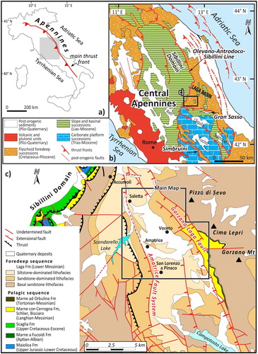
Available geological maps (CitationKoopman, 1983; CitationCentamore et al., 1991a, Citation1991b; CitationCacciuni, Centamore, Di Stefano, & Dramis, 1995) and field-based works (e.g. CitationBlumetti, Dramis, & Michetti, 1993; CitationBlumetti & Guerrieri, 2007; CitationFesta, 2005) provide regional scale information on the stratigraphic setting, tectonic structures, and morphologies that resulted from the geological history of the area surrounding the Amatrice village. Anyway, updating and detailing the knowledge of the surface geology of the area struck by the seismic crisis appear essential for: (i) assisting the geophysical-geotechnical dataset; (ii) underlining factors leading to site effects; and (iii) supporting the activities connected to the post-seismic re-building.
The surveyed area corresponds to the central part of the Amatrice Basin, a triangular-shaped morpho-structural depression developed during the post-orogenic (upper Pliocene-Quaternary) phases of the central Apennines. The main results are reported in a 1:5,000 scale geological map (three sheets in Figures A1–A3; Coordinate Reference System: WGS 84 UTM 33N – EPSG: 32633) and 31 geological cross-sections (Figures A4 and A5). The geological mapping is based on field exposures and facies analysis at local-scale, with the aim to illustrate the main stratigraphic and structural features for the central part of the Amatrice Basin.
2. Geological setting
The Amatrice Basin is an intramountain depression of the central Apennines, a Neogene fold-and-thrust belt produced by the eastward migration of the thrust fronts and related foredeep basins in a classical piggy-back style (e.g. CitationDoglioni, Harabaglia, Martinelli, Mongelli, & Zito, 1996; CitationPatacca, Sartori, & Scandone, 1990), with activation of major out-of-sequence thrust systems in the upper Messinian-Lower Pliocene time (e.g. CitationBilli & Tiberti, 2009; CitationParotto & Praturlon, 1975). One of the most external Miocene-to-Pleistocene foredeep basin of the central Apennines is represented by the Laga Basin ((b)), which hosts more than 2000 m-thick confined turbiditic bodies (the Laga Formation) including a pre-evaporitic (upper Tortonian-lower Messinian), an evaporitic (middle Messinian), and a post-evaporitic (upper Messinian) member (CitationRoveri, Bassetti, & Ricci Lucchi, 2001). Starting from the Pliocene, the post-orogenic phase shaped the previous thickened tectonic setting of the central Apennines, leading to the activation of main extensional faults (e.g. CitationCavinato & DeCelles, 1999; CitationMalinverno & Ryan, 1986; CitationPauselli, Barchi, Federico, Magnani, & Minelli, 2006) and formation of fault-bounded intramountain basins (e.g. CitationCavinato, Carusi, Dall’Asta, Miccadei, & Piacentini, 2002; CitationGiaccio et al., 2012; CitationMancini et al., 2012; CitationNocentini et al., 2017; CitationPucci et al., 2015).
Located at the southwestern portion of the Laga Basin ((c)), the Amatrice Basin is tectonically bounded by the slope-to-basinal successions of the Sibillini Domain, to the west, and of the Gran Sasso Domain, to the south. To the east, the Amatrice Basin is bounded by a major west-dipping extensional fault system (the Gorzano-Laga Fault; hereafter named GLF) that was seismically active during the late Quaternary (e.g. CitationBoncio, Lavecchia, Milana, & Rozzi, 2004; CitationCalamita & Pizzi, 1994; CitationCello, Mazzoli, Tondi, & Turco, 1997; CitationGaladini & Galli, 2003),as well as during the 2016–2017 seismic sequence (e.g. CitationLavecchia et al., 2016; CitationPizzi, Di Domenica, Gallovič, Luzi, & Puglia, 2017).
The Amatrice Basin is filled by the pre-evaporitic succession of the Laga Formation, covered by Quaternary continental units deposited during the post-orogenic phases (e.g. CitationCentamore et al., 1991a, Citation1991b; CitationCacciuni et al., 1995). The maximum thickness of the Laga Formation in the Amatrice Basin is ∼1200 m (CitationBigi, Casero, & Ciotoli, 2011). At the bottom, the Laga Formation passes to a succession of marls and marly limestones (named Marne con Cerrogna Formation and Marne ad Orbulina Formation), a Langhian-to-Lower Messinian pelagic succession that is presently exposed at the footwall of the GLF. At the top, the Laga Formation is covered by up to 60 m-thick of continental deposits (Lower Pleistocene-Holocene in age) arranged in a complex setting of alluvial fans and fluvial terraces (CitationCacciuni et al., 1995).
3. Geological survey
The 1:5,000-scale geological survey was firstly focused on the areas encompassing the main villages and hamlets that were struck by the shocking 24th August event. Then, the field survey was extended to more peripheral areas to make stratigraphic and structural correlation at the scale of the entire basin.
We performed field analyses on:
The nature, thickness, and extent of the continental cover deposits. The continental deposits were classified according to the facies analysis and stratigraphic architecture of fluvial and alluvial deposits (e.g. CitationMiall, 2016). Horizontal correlation between different terraced deposits were considered on the basis of their facies properties and their topographic position (terrace levels from the youngest to the oldest) with respect to the present-day fluvial drainage network.
The lithology of the Miocene substratum. Following the available regional mapping (CitationKoopman, 1983; CitationCentamore et al., 1991a, Citation1991b; CitationCacciuni et al., 1995) and recent stratigraphic and sedimentological studies (e.g. CitationArtoni, 2003; CitationMarini, Felletti, Milli, & Patacci, 2016; CitationMarini, Milli, Ravnås, & Moscatelli, 2015; CitationMilli, Moscatelli, Stanzione, & Falcini, 2007), particular attention was devoted to the identification and spatial distribution of the different lithofacies for the pre-evaporitic member of the Laga Formation that widely exposes in the surveyed area.
The bedding of the Miocene substratum, through the identification of primary (sedimentary in origin) or secondary (tectonic-related) mesoscale geometries. Within the different lithofacies of the Laga Formation, the bedding was firstly analysed in terms of stratigraphic way-up (direct vs. overturned) by the identification of distinguishing criteria used for sedimentary rocks (e.g. graded bedding across the bedsets, cross-laminations, convolute laminations, occurrence of sole marks and/or bioturbations; CitationCollinson, Mountney, & Thompson, 2006; CitationTucker, 1982). Then, strike and dip of bedding surfaces were measured to reconstruct the geometry of the map scale geological structures.
The spatial distribution, geometry, and kinematics of the main faults cross-cutting the Miocene substratum. The main fault surfaces were measured in terms of their strike and dip. The direction of the fault slip vectors was inferred from slickenlines, abrasion striae, grooves, and local calcite fibres. Then, particular attention was devoted to cross-cutting and overprinting relationships to understand the relative timing of slip events over fault surfaces.
4. The 1:5,000 scale geological map
4.1. Study area
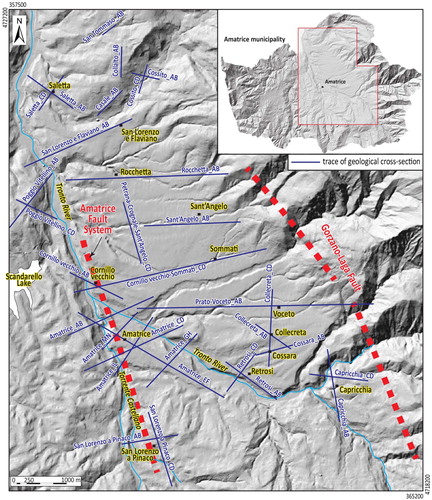
The area we mapped (about 70 km2 in surface extension) extends from the Scandarello Lake (to west) to the Gorzano Mt (to east) and encompasses most of the villages and hamlets of the Amatrice municipality, from Saletta (to north) to San Lorenzo a Pinaco (to south) ((c)).
The central-western part of the study area (i.e. west to the Voceto village; (c)) is characterised by flat-lying or mildly hilly morphology, with elevations in the 800–1000 m range. The eastern part, on the contrary, is characterised by a steep morphology corresponding to the western flank of the Gorzano Mt, with elevations up to 1500 m (). Along the western flank of the Gorzano Mt, westerly down-stepped and relatively flat-topped relieves at intermediate elevations occur.
Figure 2. – Eastward panoramic view of the surveyed area with indication of the Amatrice village, in the foreground, and the trace of the Gorzano Fault, in the background.
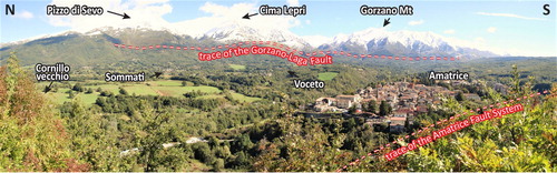
The study area is drained by the Tronto River and its tributaries. The main trunk of the Tronto River, which flows northward, is disposed WNW-ESE near Amatrice and Retrosi villages, then it turns NNW-SSE towards the Saletta village, to the N. Steep escarpments (from few metres to 40 m) run along both the main trunk of the Tronto River and its tributaries.
4.2. Stratigraphy
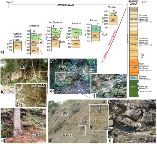
We distinguished three main stratigraphic-sedimentary systems by combining analysis of selected stratigraphic-sedimentologic logs ((a)) and observation of field exposures ((b–i)). These are, from top to bottom: (i) the ubiquitous Quaternary continental deposits, (ii) the Pleistocene continental deposits, and (iii) the Miocene substratum.
Figure 3. (a) Selected stratigraphic logs and (b)-(i) field exposures used for reconstructing the general stratigraphy; (b–c) Retrosi Unit (URT): clast-supported conglomerates and gravels; (d) Amatrice-Sommati Unit, sandy member (UASs): yellowish massive-to-slightly bedded sands with silty matrix; (e–f) Amatrice-Sommati Unit, conglomeratic member (UASc): tabular conglomerates and gravels; (g–h) Laga Formation, siltstone-dominated lithofacies (LAGp): well bedded, centimetre-to-decimetre-thick planar beds of beige siltstone; (i) Laga Formation, sandstone-dominated lithofacies (LAGa): massive tabular and lenticular beds of grey to brown, medium-sized sandstone.
4.2.1. The ubiquitary Quaternary continental deposits
The ubiquitary Quaternary continental deposits are scattered within the investigated area. These deposits include:
anthropogenic deposits (ra);
landslide deposits (df), including slides and rockfalls. Holocene-Present in age;
recent fluvial and floodplain deposits (da). Holocene-Present in age;
colluvium (dc). Holocene-Present in age;
silty sands glacis deposits (dg) and encased lenses of slope deposits (dt). Upper Pleistocene-Present in age;
terraced alluvial deposits (db) flanking the present Tronto River and its tributaries. Upper Pleistocene in age.
4.2.2. Pleistocene continental deposits
The Pleistocene continental deposits consist of a series of aggradational river terraces (CitationCacciuni et al., 1995) reaching the maximum thickness (up to 60 m) at the centre of basin, i.e. below Rocchetta, Sommati and San Lorenzo e Flaviano villages.
The Pleistocene succession encompasses two main units: the Retrosi Unit and the Amatrice-Sommati Unit.
The Retrosi Unit (URT) corresponds to an aggradational terrace consisting of up to 30–40 m thick clast-supported conglomerates and gravels ((b,c)), locally covered by few metres of fine sands. The age of the URT is inferred to be Middle Pleistocene on the base of stratigraphic correlation (CitationCacciuni et al., 1995);
The Amatrice-Sommati Unit (UAS), consisting of up to 60 m-thick fluvial deposits of active channel environment and alluvial fan deposits, encompasses a lower conglomeratic member (UASc) and an upper sandy member (UASs). While the UASs member is composed of massive-to-horizontal bedded sands with silty matrix and lenticular clusters of rounded cobbles ((d)), the UASc member is composed of the multistorey and multilateral stack of lenticular and tabular conglomerates and gravels ((e,f)). The overall UAS is attributed to the Lower-Middle Pleistocene based on morphologic-stratigraphic correlation with regional stratigraphy of the central Apennines (CitationBlumetti & Guerrieri, 2007; CitationBlumetti et al., 1993; CitationCacciuni et al., 1995).
4.2.3. Miocene substratum
The Miocene substratum encompasses, from top to bottom, the pre-evaporite succession of the Laga Formation, the Marne ad Orbulina Formation, and the Marne con Cerrogna Formation.
The pre-evaporite member of the Laga Formation (up to 850 m on outcrop) is composed of siliciclastic turbidite deposits of the deep-sea fan depositional system (CitationMarini et al., 2015, Citation2016; CitationMilli et al., 2007). This turbidite succession includes three main lithofacies associations, which are from top to bottom: (i) a siltstone-dominated lithofacies (LAGp) composed of well bedded, centimetre-to-decimetre-thick planar beds of grey to beige siltstone ((g,h)) locally alternated with fine sandstone and 2-to-6 m thick bedsets of tabular sandstone; (ii) a sandstone-dominated lithofacies (LAGa) composed of 1–6 m thick massive tabular and lenticular beds of grey to brown, medium-sized sandstone ((i)), locally interlayered with dm-thick siltstone beds; and (iii) the basal sandstones (LAGab) consisting of tabular and lenticular bedsets (2–8 m thick and several decametres wide) of grey to beige, medium-sized, massive to through cross-laminated sandstone. The age of this pre-evaporite member is lower Messinian (CitationCentamore et al., 1991a, Citation1991b; CitationFesta, 2005).
The Marne ad Orbulina Formation (MOR) is composed of 60 m thick, blue-grey laminated marls organised into thin (5–10 cm thick), regular planar beds. The age is Tortonian (CitationCentamore et al., 1991a, Citation1991b; CitationFesta, 2005).
The Marne con Cerrogna Formation (MCC) is composed of grey, massive or crudely stratified marls intercalated with several metres thick lenses of calcarenite. The age is Langhian-Tortonian (CitationCentamore et al., 1991a, Citation1991b; CitationFesta, 2005).
4.3. Structural dataset
We collected structural information about the bedding surfaces (both right-side and overturned) of the LAGa and LAGp lithofacies. The statistical analysis of the right-side bedding dataset shows dominant NW-SE and NE-SW orientations ((a)). The NW-SE-striking bedding occurs on the western sector of the surveyed area (i.e. along the Tronto River), as well as along the western flank of the Gorzano Mt and approaching the GLF, on the eastern sector. The NE-SW-striking bedding mainly prevails within the central portion of the basin, eastward to the Tronto River, where minor undulation of the bedding are due to local folds with a wavelength in the order of few tens of metres. The NW-SE-striking overturned, west-dipping bedding occurs along the morphological ridge located between the Torrente Castellano and the Scandarello Lake (to the west of the Tronto River), where both the LAGa and LAGp are deformed in anticline-syncline geometries associated to reverse faulting.
Figure 4. Stereographic projections (Schmidt net, lower hemisphere) for (a) the bedding of the Laga Formation and (b) the normal faults detected in the study area.
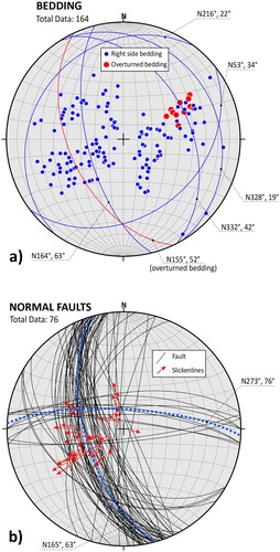
Tectonic structures affecting the Miocene substratum include reverse faults, normal faults, and undefined faults (i.e. whose kinematics has been not clarified). NW-SE-striking reverse faults prevails on the westernmost part of the surveyed area (i.e. the area surrounding the Scandarello Lake), causing the stacking of both the LAGa and LAGp in a multi-layered succession.
The cumulative analysis of normal faults data ((b)) shows a dominant population oriented NW-SE (N165°, 63°) and a subordinate population oriented E-W (N273°, 76°). Normal faults are widely distributed within the basin and they mainly belong to the GLF (on the eastern side of the surveyed area) and to the Amatrice Fault System (running in the central part of the surveyed area, to the west of Amatrice). Normal fault segments belonging to the GLF are mainly NW-SE-striking and dipping to SW at angles higher than 50°. Several branches and segments of the GLF run at lower altitudes moving towards the centre of the basin. The Amatrice Fault System consists of a complex network of up-to-1 km-long, NNW-SSE-striking fault segments that are interrupted and dislocated by the E-W-striking fault segments. Some of the NNW-SSE-striking faults have morphological expression through the occurrence of steep escarpments running along eastern banks of the Tronto River and the Torrente Castellano, bounding NW-SE-striking morphological ridge from Cornillo Vecchio to Arafranca-Pinaco, from north to south.
5. Geological cross-sections
We present 31 geological cross-sections at scale 1:5,000 mainly centred across the urban settlements (, A4, A5). Geological cross-sections were oriented as much as possible perpendicular to the dominant strike of bedding strata and/or tectonic structures (e.g. faults), with the aim to show thickness and lateral-vertical stratigraphic relationships between the Quaternary continental deposits and the Miocene substratum, as well as the attitude and throw of the main fault systems.
Figure 5. Location of the geological cross-sections presented in Figures A4, A5.
Areas characterised by complex stratigraphic relationships (e.g. sharp lateral thickness variation, interfingering, change in bedding attitude) were investigated by roughly perpendicular, and intersecting, cross-sections (see cross-sections named Saletta, Poggio Vitellino, Retrosi, Amatrice, Capricchia in , A4, A5), with the aim to reconstruct the three-dimensional spatial geometry of the subsurface settings.
Areas characterised by wide exposure of the Pleistocene continental deposits were investigated by a series of parallel cross-sections, with the aim to document thickness variation and internal stratigraphic architecture of these post-orogenic covers, as well as their relationships with the underlying Laga Formation lithofacies (see cross-sections named Rocchetta_AB, Sant’Angelo_AB, and Prato-Voceto_AB in , A4, A5).
Areas characterised by complex network of fault systems (e.g. along the Amatrice Fault System) were investigated by a series of parallel and hectometre-spaced cross-sections, with the aim to highlight along-strike and across-strike variations of throw and bedding attitude (see cross-sections named Cornillo Vecchio-Sommati, Amatrice, and San Lorenzo a Pinaco in , A4, A5).
6. Discussion
The 1:5,000 scale map (Figures A1–A3) and cross-sections (Figures A4 and A5) presented in this work provide an accurate cartographic tool for the geological understanding of the Amatrice Basin in central Apennines (Italy). The presented geological dataset updates regional-scale geological maps available for the Amatrice Basin in terms of origin, nature, spatial distribution of the main lithotypes (belonging both to the Quaternary continental deposits and to the Miocene substratum) and relevance of tectonic deformation pattern.
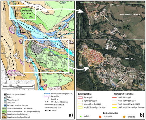
The detailed scale of mapping provides the base for supporting and integrating the wide multidisciplinary (seismological, geotechnical, geophysical, engineering) dataset produced for the Amatrice Basin. In particular, we refer to local-scale subsoil models aimed at assessing the earthquake-induced site effects in comparison to the observed damage pattern since the first seismic event on August 2016. The resultant geological map provides spatially distributed information useful for evaluating the effects due to the seismic amplification and the polarisation of seismic waves, as well as to understand additional causative elements that may be at the origin of the elevated damage level. As an example, in (a,b) is shown the different damage suffered by the Amatrice village and the Cornillo Vecchio settlement after the 24th August 2016 seismic schock.
Figure 6. (a) Extract of the 1:5,000 scale geological map (see the Main Map; Figures A1–A3) used for comparison with the (b) damage pattern (buildings, roads, and crisis information) detected after the first seismic sequence (on 24th August 2016). Grading maps are available at http://emergency.copernicus.eu/mapping/list-of-components/EMSR177.
On this regard, we conclude that a detailed geological survey contributes to reinforce the study of seismic microzonation and the assessing of seismic hazard in urban areas.
Software
The collected field dataset was georeferenced using QGIS 2.12.1 version. Final editing of the main map and the cross-sections was performed using Adobe Illustrator CS6.
plate of cross sections 2/2
Download PDF (24.9 MB)plate of cross sections 1/2
Download PDF (24.9 MB)map sheet 3/3
Download PDF (26.4 MB)map sheet 2/3
Download PDF (23.8 MB)map sheet 1/3
Download PDF (32.7 MB)Acknowledgments
Authors thank B. Giaccio, I. Mazzini, and A. Sposato for useful discussions and suggestions. The Editor (Mike J. Smith) and the Associate Editor (Arthur Merschat) are thanked for the editorial handling. The manuscript and the main map benefitted from comments and suggestions by three Reviewers (Andrea Tertulliani, John Abraham, and Marco Spadi), who are warmly thanked.
Disclosure statement
No potential conflict of interest was reported by the authors.
ORCID
G. Vignaroli http://orcid.org/0000-0001-7345-6162
F. Bucci http://orcid.org/0000-0002-0928-9504
M. Cardinali http://orcid.org/0000-0002-0788-6647
M. Moscatelli http://orcid.org/0000-0001-7902-2322
M. Santangelo http://orcid.org/0000-0003-1299-9192
G. Cosentino http://orcid.org/0000-0001-8691-3430
Additional information
Funding
Related Research Data
References
- Aringoli, D., Farabollini, P., Giacopetti, M., Materazzi, M., Paggi, S., Pambianchi, G., … Tondi, E. (2016). The August 24th 2016 Accumoli earthquake: Surface faulting and deep Seated Gravitational slope deformation (DSGSD) in the Monte Vettore area. Annals of Geophysics, 59, fast track 5. doi:10.4401/ag-7199.
- Artoni, A. (2003). Messinian events within the tectono-stratigraphic evolution of the Southern Laga Basin (central Apennines, Italy). Bollettino della Società Geologica Italiana, 122, 447–465.
- Bigi, S., Casero, P., & Ciotoli, G. (2011). Seismic interpretation of the Laga basin; constraints on the structural setting and kinematics of the central Apennines. Journal of the Geological Society, London, 168, 179–190. doi: 10.1144/0016-76492010-084
- Billi, A., & Tiberti, M. M. (2009). Possible causes of arc development in the Apennines, central Italy. Geological Society of America Bulletin, 121, 1409–1420. doi: 10.1130/B26335.1
- Blumetti, A. M., Dramis, F., & Michetti, A. M. (1993). Fault-generated mountain fronts in the central Apennines (central Italy): geomorphological features and seismo-tectonic implications. Earth Surface Processes and Landforms, 18, 203–223. doi: 10.1002/esp.3290180304
- Blumetti, A. M., & Guerrieri, L. (2007). Fault-generated mountain fronts and the identification of fault segments: Implications for seismic hazard assessment. Bollettino della Società Geologica Italiana, 126(2), 307–322.
- Boncio, P., Lavecchia, G., Milana, G., & Rozzi, B. (2004). Seismogenesis in central Apennines, Italy: An integrated analysis of minor earthquake sequences and structural data in the Amatrice-Campotosto area. Annals of Geophysics, 47, 1723–1742.
- Cacciuni, A., Centamore, E., Di Stefano, R., & Dramis, F. (1995). Evoluzione morfotettonica della conca di Amatrice. Studi Geologici Camerti, Volume speciale 1995(2), 95–100.
- Calamita, F., & Pizzi, A. (1994). Recent and active extensional tectonics in the Southern Umbro-Marchean Apennines (central Italy). Memorie della Società Geologica Italiana, 48, 541–548.
- Caserta, A., Doumaz, F., Costanzo, A., Gervasi, A., Thorossian, W., Falcone, S., … Buongiorno, M. F. (2016). Assessing soil-structure interaction during the 2016 central Italy seismic sequence (Italy): preliminary results. Annals of Geophysics, 59, fast track 5. doi: 10.4401/ag-7250
- Cavinato, G. P., Carusi, C., Dall’Asta, M., Miccadei, E., & Piacentini, T. (2002). Sedimentary and tectonic evolution of Plio-Pleistocene alluvial and lacustrine deposits of Fucino Basin (central Italy). Sedimentary Geology, 148, 29–59. doi: 10.1016/S0037-0738(01)00209-3
- Cavinato, G. P., & DeCelles, P. G. (1999). Extensional basins in the tectonically bimodal central Apennines fold-thrust belt, Italy: Response to corner flow above a subducting slab in retrograde motion. Geology, 27, 955–958. doi:10.1130/0091-7613(1999)027<0955:EBITTB>2.3.CO;2
- Cello, G., Mazzoli, S., Tondi, E., & Turco, E. (1997). Active tectonics in the central Apennines and possible implications for seismic hazard analysis in peninsular Italy. Tectonophysics, 272, 43–68. doi: 10.1016/S0040-1951(96)00275-2
- Centamore, E., Adamoli, L., Berti, D., Bigi, G., Bigi, S., Casnedi, R., … Salvucci, R. (1991a). Carta geologica del bacino della Laga e del Cellino e delle zone limitrofe. S.EL.CA., Firenze.
- Centamore, E., Cantalamessa, G., Micarelli, A., Potetti, M., Berti, D., Bigi, S., … Ridolfi, M. (1991b). Stratigrafia e analisi di facies dei depositi del Miocene e del Pliocene inferiore dell’avanfossa marchigiano- abruzzese e delle zone limitrofe. Studi Geol. Camerti Vol. Spec., 1991/2, 125–131.
- Collinson, J., Mountney, N., & Thompson, D. (2006). Sedimentary structures (3rd ed.). Edimburgh: Terra Publishing. p. 292.
- Cultrera, G., D’Alema, E., Amoroso, S., Angioini, B., Bordoni, P., Cantore, L., … Vassallo, M. (2016). Site effect studies following the 2016 Mw 6.0 Amatrice earthquake (Italy): the Emersito Task Force activities. Annals of Geophysics, 59, fast track 5. doi: 10.4401/ag-7189
- Doglioni, C., Harabaglia, P., Martinelli, G., Mongelli, F., & Zito, G. (1996). A geodynamic model of the Southern Apennines accretionary prism. Terra Nova, 8, 540–547. doi: 10.1111/j.1365-3121.1996.tb00783.x
- EMERGEO W.G. (2016). Coseismic effects of the 2016 Amatrice seismic sequence: First geological results. Annals of Geophysics, 59, fast track 5. doi: 10.4401/ag-7195
- Falcucci, E., Gori, S., Galadini, F., Fubelli, G., Moro, M., & Saroli, M. (2016). Active faults in the epicentral and mesoseismal Ml 6.0 24, 2016 Amatrice earthquake region, central Italy. Methodological and seismotectonic issues. Annals of Geophysics, 59, fast track 5. doi:10.4401/ ag-7266
- Festa, A. (2005). Geometrie e meccanismi di raccorciamento nel settore meridionale del Bacino marchigiano (Monte Gorzano, Appennino Centrale). Bollettino della Società Geologica Italiana, 124, 41–51.
- Galadini, F., & Galli, P. (2003). Paleoseismology of silent faults in the central Apennines (Italy): the Mt. Vettore and Laga Mts. Faults. Annals of Geophysics, 46, 815–836.
- Galli, P., Castenetto, S., & Peronace, E. (2017). The macroseismic intensity distribution of the 30 October 2016 earthquake in central Italy (Mw 6.6): Seismotectonic implications. Tectonics, 36, 2179–2191. doi: 10.1002/2017TC004583
- Galli, P., Peronace, E., Bramerini, F., Castenetto, S., Naso, G., Cassone, F., & Pallone, F. (2016). The MCS intensity distribution of the devastating 24 August 2016 earthquake in central Italy (MW 6.2). Annals of Geophysics, 59, fast track 5. doi: 10.4401/ag-7287
- Gaudiosi, I., Vignaroli, G., Sirianni, P., Giallini, S., Mori, F., Polpetta, F., … Moscatelli, M. (2016). Local seismic response studies in the north-western portion of the August 24th, 2016 Mw 6.0 earthquake affected area. The case of Visso village (central Apennines). Annals of Geophysics, 59, fast track 5. doi:10.4401 / AG – 7258
- Giaccio, B., Galli, P., Messina, P., Peronace, E., Scardia, G., Sottili, G., … Silvestri, S. (2012). Fault and basin depocentre migration over the last 2 Ma in the L’Aquila 2009 earthquake region, central Italian Apennines. Quaternary Science Reviews, 56, 69–88. doi: 10.1016/j.quascirev.2012.08.016
- Koopman, A. (1983). Detachment tectonics in the central Apennines. Geological Ultraiectina, 30, 1–155.
- Lavecchia, G., Castaldo, R., de Nardis, R., De Novellis, V., Ferrarini, F., Pepe, S., … Tizzani, P. (2016). Ground deformation and source geometry of the 24 August 2016 Amatrice earthquake (central Italy) investigated through analytical and numerical modeling of DInSAR measurements and structural-geological data. Geophysical Research Letters, 43, 12,389–12,398. doi: 10.1002/2016GL071723
- Livio, F., Michetti, A. M., Vittori, E., Gregory, L., Wedmore, L., Piccardi, L., … Roberts, G. (2016). Surface faulting during the August 24, 2016, central Italy earthquake (Mw 6.0): preliminary results. Annals of Geophysics, 59, fast track 5. doi: 10.4401/ag-7197
- Malinverno, A., & Ryan, W. B. (1986). Extension in the Tyrrhenian Sea and shortening in the Apennines as result of arc migration driven by sinking of the lithosphere. Tectonics, 5, 227–245. doi: 10.1029/TC005i002p00227
- Mancini, M., Cavuoto, G., Pandolfi, L., Petronio, C., Salari, L., & Sardella, R. (2012). Coupling basin infill history and mammal biochronology in a Pleistocene intramontane basin: The case of western L’Aquila Basin (central Apennines, Italy). Quaternary International, 267, 62–77. doi: 10.1016/j.quaint.2011.03.020
- Marini, M., Felletti, F., Milli, S., & Patacci, M. (2016). The thick-bedded tail of turbidite thickness distribution as a proxy for flow confinement: Examples from tertiary basins of central and northern Apennines (Italy). Sedimentary Geology, 341, 96–118. doi: 10.1016/j.sedgeo.2016.05.006
- Marini, M., Milli, S., Ravnås, R., & Moscatelli, M. (2015). A comparative study of confined vs. semi-confined turbidite lobes from the Lower Messinian Laga Basin (central Apennines, Italy): implications for assessment of reservoir architecture. Marine and Petroleum Geology, 63, 142–165. doi: 10.1016/j.marpetgeo.2015.02.015
- Mariucci, M. T., Montone, P., & Pierdominici, S. (2010). Present-day stress in the surroundings of 2009 L’Aquila seismic sequence (Italy). Geophysical Journal International, 182, 1096–1102. doi: 10.1111/j.1365-246X.2010.04679.x
- Miall, A. D. (2016). Stratigraphy: A Modern Synthesis. Cham: Springer International Publishing, p. 454.
- Milli, S., Moscatelli, M., Stanzione, O., & Falcini, F. (2007). Sedimentology and physical stratigraphy of the Messinian turbidite deposits of the Laga Basin (central Apennines, Italy). Bollettino della Società Geologica Italiana, 126, 255–281.
- Nocentini, M., Asti, R., Cosentino, D., Durante, F., Gliozzi, E., Macerola, L., & Tallini, M. (2017). Plio-Quaternary geology of L’Aquila – Scoppito Basin (central Italy). Journal of Maps, 13(2), 563–574. doi: 10.1080/17445647.2017.1340910
- Parotto, M., & Praturlon, A. (1975). Geological summary of the central Apennines. In L. Ogniben, M. Parotto, & A. Praturlon (Eds.), Structural model of Italy, Quaderni della Ricerca Scientifica (Vol. 90, pp. 257–311). Rome: Consiglio Nazionale delle Ricerche.
- Patacca, E., Sartori, R., & Scandone, P. (1990). Tyrrhenian basin and Apenninic arcs: Kinematic relation since late Tortonian times. Memorie della Società Geologica Italiana, 45, 425–451.
- Pauselli, C., Barchi, M. R., Federico, C., Magnani, B., & Minelli, G. (2006). The crustal structure of the Northern Apennines (central Italy): an insight by the CROP03 seismic line. American Journal of Science, 306, 428–450. doi: 10.2475/06.2006.02
- Pischiutta, M., Akinci, A., Malagnini, L., & Herrero, A. (2016). Characteristics of the Strong Ground Motion from the 24th August 2016 Amatrice earthquake. Annals of Geophysics, 59, fast track 5. doi: 10.4401/AG-7219
- Pizzi, A., Di Domenica, A., Gallovič, F., Luzi, L., & Puglia, R. (2017). Fault segmentation as constraint to the occurrence of the main shocks of the 2016 central Italy seismic sequence. Tectonics, 36, 2370–2387. doi: 10.1002/2017TC004652
- Pucci, S., Villani, F., Civico, R., Pantosti, D., Del Carlo, P., Smedile, A., … Gueli, A. (2015). Quaternary geology of the Middle Aterno Valley, 2009 L’Aquila earthquake area (Abruzzi Apennines, Italy). Journal of Maps, 11(5), 689–697. doi: 10.1080/17445647.2014.927128
- Roselli, P., & Mariucci, M. T. (2016). Preliminary earthquake focal mechanism forecasts for the Amatrice sequence (central Italy). Annals of Geophysics, 59, fast track 5. doi: 10.4401/ag-7306
- Roveri, M., Bassetti, M. A., & Ricci Lucchi, F. (2001). The Mediterranean Messinian salinity crisis: An Apennine foredeep perspective. Sedimentary Geology, 140, 201–214. doi: 10.1016/S0037-0738(00)00183-4
- Smeraglia, L., Billi, A., Carminati, E., Cavallo, A., & Doglioni, C. (2017). Field- to nano-scale evidence for weakening mechanisms along the fault of the 2016 Amatrice and Norcia earthquakes, Italy. Tectonophysics, 712-713, 156–169. doi: 10.1016/j.tecto.2017.05.014
- Tinti, E., Scognamiglio, L., Michelini, A., & Cocco, M. (2016). Slip heterogeneity and directivity of the ML 6.0, 2016, Amatrice earthquake estimated with rapid finite-fault inversion. Geophysical Research Letters, 43, 10,745–10,752. doi: 10.1002/2016GL071263
- Tucker, M. (1982). The Field Description of Sedimentary Rocks. Geological Society of London Handbook Series, No. 2. Open University Press, p. 124.