
ABSTRACT
From rocks to clay, a shared interest in natural materials and their physical transformation provided the initial common ground for an interdisciplinary art-geoscience collaborative project that also opened up a novel and engaging public communication channel. Scientific data collected for a location-based geomorphology mapping project was collaboratively re-interpreted and re-presented as a craft installation by using digital technologies and hand-crafted processes. The project explored how creative practice can uncover and broaden narratives, layering interpretations whilst respecting and embracing the need for accurate visual representation of scientific data. As the practice-based element of a broader digital craft PhD research programme, the project effectively demonstrated an enlarged field of practice for digital craft. The collaboration resulted in a large-scale, porcelain panelled, wall-mounted installation for public exhibition and has led to subsequent significant unforeseen developments in the scope and outlook of research work undertaken by the collaborators. This paper reflects on the synergies between disciplines that were uncovered and how project challenges were met. We conclude that the project work acted as a ‘boundary object’ for the two collaborating parties, able to represent different values and fulfil different objectives for each party at the same time, while also moving forward practice for both.
1. Introduction
The initial impetus for this collaboration arose from a PhD research project, undertaken by Risner and supervised by Marshall, that investigated changes in crafts practice resulting from makers using digital tools (CitationRisner, 2013). Extensive research has examined how the sense of the material, embodied – and, crucially, performative – practice of craft is situated in relation to digital technologies, and also has examined the implications of new digital directions for practice (CitationBunnell, 1998; CitationDormer, 1997; CitationMarshall, 1999; CitationMcCullough, 1998). Increasingly, craft practitioners make use of widely available digital technologies and networks that may include digitally encoded data, digital design programmes, digital manufacturing tools such as laser cutters, CNC mills, or 3D printers. Makers are often active participants in online digital communities, which offer new ways to learn skills, make connections, and market work (CitationYair, 2011).
Risner's PhD argued that a new strand of craft practice has emerged from digital engagement, one that embraces the collaborative nature of the ‘digital proposition’ for craft. This strand has shifted practitioners away from productive autonomy – control over their own tools and materials in an ‘in the moment’ engagement – towards a more extended engagement mediated through software, digital making technologies, and a wider field of expertise. The PhD research examined, identified, and defended the existence of craft process within digitally enhanced practice. It looked at engaged, complex, and iterative yet digitally-enabled work, and described such work as a new craft genre titled technepractice (CitationRisner, 2013, p. 68).
An art-geoscience collaboration was identified as a way to explore and showcase one of the key benefits to crafts practitioners of working digitally, namely the potential for using digital data as a source of rich narrative content in craft work. The subsequent work, and the relative novelty of the approach, can be situated in the developing field of digital craft practice between the early 2000s and the early 2010s. At this time, digital production techniques and the manipulation and translation of digital data were being explored by a number of practitioners across a variety of material specialisms. The Crafts Council's Lab Craft, launched in 2010, was the first significant national touring exhibition to focus on this work, and featured work by makers such as Geoff Mann and Gary Allson who in their own ways used translated data to drive new aesthetic outcomes.
This paper explores the nature of our collaboration, including the role of mapping as an underpinning element of the work, and reflects on the mutual benefits derived for the craftspeople (Risner, Marshall) and scientist (Naylor) involved. Specifically, we explore how adding geoscience to creative practice research enabled a richness and impact that enhanced both collaborative parties. In particular, for Naylor, this first art-geoscience collaboration has been a springboard into the world of creative practice, where she has since consistently worked with designers and makers on externally-funded projects.
1.1. Basis of collaboration
At first glance, geomorphology and craft would seem to be an unlikely interdisciplinary partnership. Geomorphology is ‘the study of landforms, their processes, form and sediments at the surface of the Earth’ (CitationBritish Society for Geomorphology, 2017), whilst ‘craft’ denotes a practice-based creative discipline in which sensitive engagement with materials and processes are important characteristics of the practice. Craft is often identified through the quality of making, associated with and rooted in hand skill, and has a ‘deep connection to materiality and cultural continuity’ (CitationAdamson, 2013, p. xxii). Their classification within modern university structures clearly places a science-arts boundary between geomorphology and craft, yet their shared sensitivities towards materials and material transformation provides a strong bridge. There has been a significant history of previous geomorphology-artistic collaboration; for example, see the discussion of ‘Art-full Geomorphology’ by CitationHawkins (2017, p. 307). Geomorphology and craft are both fundamentally concerned with the study of the physical transformation of the material world, and how change is wrought in natural materials, either by nature or design (in our case, and as detailed below, rocks and clay). With a narrower focus in mind, the two sides of the collaboration also clearly shared an interest in visual communication (mapping and form), in transferable digital data, and in the environmental narrative that was the central subject of the project work.
Further unexpected parallels between geomorphology and craft emerged through our collaboration. Geomorphology has historically been a field-based, descriptive to semi-quantitative field that has undergone several revolutions into much more computer-driven quantitative science (e.g. the quantitative revolution of the 1970s) and now is engaging with advanced spatial technologies (e.g. drones) as tools to help measure and interpret landscape change (CitationViles, 2016). The sense of digital transformation is echoed in the rise of technepractice in craft, which sees craft taking on a new forward looking and interdisciplinary embrace of technology.
Geomorphologists are interested in understanding the spatial and temporal variations in how the landscape erodes and how it is built and rebuilt. This has parallels with sculptural craft practice in which sculptural forms are built from malleable raw materials, and which can often change (e.g. shrink) during the creative process. Porcelain is a material able to convey a sense of delicate and subtle beauty while also being known for its toughness, strength, and translucency. The fluidity of porcelain clay, transformed into translucent ceramic after kiln firing at high temperature, also reflects the geomorphology here examined, namely the rapid movement of boulders during storm events that then appear to be fixed and immoveable. Thus, in the collaboration, both parties discovered that they similarly work with materials that are at times in state of flux, the nature of which is sensitive to background environmental conditions (e.g. weather, temperature, humidity).
Our collaboration grew from the opportunity to exhibit work as part of the 13th Appledore Visual Arts Festival entitled Coastlines (June 2010). Risner sought out a scientist able to provide data and keen to collaborate in the creation of an installation for public exhibition. With Naylor's involvement, the geomorphological basis to this collaboration concerned an important and novel investigation into coastal change. Rock coasts are commonly thought to change infrequently; this research showed the opposite, namely that coastal boulders on rock coasts can move rapidly during storms. High-resolution (daily) field data were used to measure and characterise coastal boulder transport before, during, and after the extreme Northeast Atlantic extra-tropical cyclone ‘Johanna’ in March 2008 (CitationNaylor et al., 2016).
The objectives of this interdisciplinary collaboration were therefore three-fold:
From the crafts side, initial PhD research had found that data transfer – the sharing and use of digital data as a rich source of narrative content and creative inspiration for work – was a key means of extending craft practice cited by crafts practitioners. Risner sought to investigate, and potentially provide evidence through an in-depth documented example, the way in which data transfer can be the basis of collaborative engagement and extended crafts practice.
From the geomorphology side, Naylor wanted to explore a new direction in the mapping and presentation of previously collected scientific data (at the time unpublished) and expose the data to interdisciplinary scrutiny and novel interpretation. Visual representation was seen as an ideal method to communicate the unexpected, underlying nature of a natural phenomenon, i.e. that rock coasts actually change rapidly during storms. Naylor also sought to explore whether creative practice and public exhibition was an effective medium for increasing the visibility of geomorphic science (CitationTooth et al., 2016) and aid communication of geomorphology to a wider audience (CitationClarke, Schillereff, & Shuttleworth, 2017; CitationGregory et al., 2014).
For both parties, there was a desire to explore creative practice as a means for integrating and communicating complex subjects and providing a visual entry point for conversation. As CitationHawkins (2017, p. 318) explains:
For those within the science community, global environmental change poses challenges around how to appreciate the multiple perspectives needed to understand the environment, but also how to close gaps between understanding in the academic community and action in the world’.
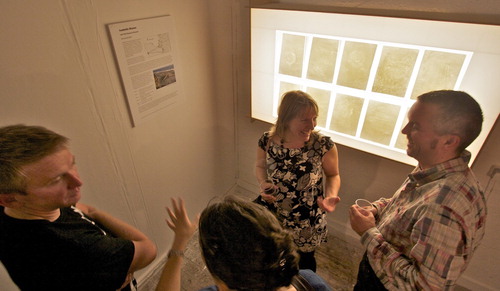
Figure 1. Moving Boulders: Wall-mounted porcelain panels and light box
Nevertheless, interdisciplinary projects, and particularly arts-science projects, have attracted criticism in instances where they have been seen to operate in ‘subordination-service mode’, i.e. with the arts component essentially ‘providing a service to science rendering it more popular or accessible’ (CitationBarry, Born, & Weszkalnys, 2008, p. 29). In such instances, a short-lived project may result in a division of labour, and disciplinary boundaries that remain intact, with the resulting outcomes sometimes seen as ‘decorative’ or ‘celebratory’ (CitationBarry et al., 2008, p. 39). We argue that, in our case, the prior existence of specific and challenging disciplinary objectives on both sides, and a willingness to explore beyond our own fields, resulted in an inventive outcome that went ‘beyond the demands for accountable science’ (CitationBarry et al., 2008, p. 41) and resulted in a changed understanding of practice for both parties.
This outcome relates to the use of the mapping data and the resulting craft work as ‘boundary objects’. Boundary objects are ‘objects which both inhabit several intersecting social worlds … and satisfy the informational requirements of each of them … . The creation and management of boundary objects is a key process in developing and maintaining coherence across intersecting social worlds’ (CitationStar & Griesemer, 1989, p. 393). Here, the project work itself was able to meet the separate objectives of both parties, and while the investment in the craft work was shared between the collaborators, each party maintained a distinct understanding of its value, as discussed later in the paper.
1.2. Making the work: the base map
After a broad discussion of several possibilities for collaboration (see next section), it was agreed that one data set – measurements taken of boulder movements across a rocky shore platform – provided a suitable informational basis on which to build a collaborative experiment. The data were collected using conventional geomorphic mapping methods. Data on individual daily boulder movements were collected using a differential Global Positioning System (dGPS) and plotted using a Geographic Information System (GIS) to measure daily transport distance.
These boulders weighed up to 0.75 t and were up to 1.5 metres long. CitationNaylor et al.’s (2016) work has revealed the surprising mobility and pace of change in these types of rock configurations in particular conditions. In itself, this is a novel and counter-intuitive scientific finding from the point of view of both public and scientific perception, since these are boulders which look, to the untrained eye, to be utterly immovable, and even scientists have previously attributed their movement to tsunami rather than storms.
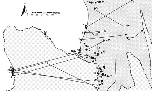
We worked over the course of two weeks to create a composite map in Adobe Illustrator () that represented the boulder movement. This map was produced by adapting, tracing and re-drawing the scientific mapping data already available, and cross-checking data. The process of getting the map right was highly iterative and involved several draft versions to reach the level of scientific accuracy, artistic interpretation, and clarity of representation that satisfied both parties.
Figure 2. The final base map artwork, April 2010 (I. Risner, Citation2013).
From a geomorphology perspective, the mapping and subsequent layering of data onto this map () was fascinating as it brought to life key geomorphic concepts such as landscapes as palimpsests (CitationLivingstone, Cofaigh, & Evans, 2008), and allowed us to layer landscape process change over time (albeit short-term individual storm event timescales) with a suite of policy and cultural information. This approach of using geomorphic data to form the basis of the mapping, with subsequent layering of cultural, climate change and policy issues, brought to the fore the complexity of managing coastal climate change risks in an accessible and aesthetically pleasing and interesting visual form. The strong value of this approach as a public engagement tool is discussed later (see ‘Exhibition’ section).
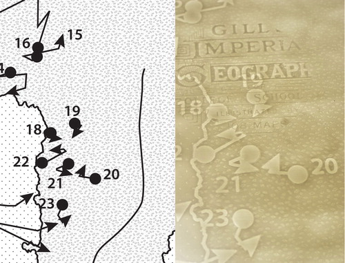
Figure 3. Left) The Boulder Trap, digital artwork for Panel 9, 200 × 300 mm (I. Risner, Citation2013). Right) Porcelain panel of the Boulder Trap and overlaid imagery after kiln firing.
2. Working together
Working across disciplines presents particular challenges. A level of trust and understanding has to be established by open communication and by taking small steps through a process of sustained social learning (CitationMeasham, 2013); this allows the collaborators to build an initial relationship into a partnership. In our case, the relationship was crucial to success and built slowly. Risner initially provided samples of previous porcelain she had made, establishing her credentials as a practitioner, and explained both the difficulties and potentials of working with porcelain. The translucent properties of porcelain enable the layering of multiple images, and by sharing knowledge of how the craft materials behave, both parties were able to fully engage with how aspects of science, policy, environmental change, and social value could be meaningfully incorporated. The digital craft processes that developed, and the use of porcelain, allowed us to encapsulate the complex issues that play out for society when grappling with coastal change. In essence, we created a visually-rich palimpsest where we jointly and delicately layered geomorphology and craft.
In our case, the attraction of collaborating across disciplinary boundaries was equally apparent from both sides. One of the major challenges of this kind of collaboration is the need to ‘respect the skill and experience of other disciplines’ which are ‘learned differently … involve different skill-sets and different modes of engagement and assessment’ (CitationHawkins, 2017, p. 345). Both parties quickly realised that there was an opportunity to do something novel, and the term ‘exciting’ was one that occurred early on in the emails from both parties. There was a shared sense of curiosity, vitality and mutual interest in interdisciplinary collaboration. This may relate to creativity being engendered by unusual combinations. From craft theory, CitationSennet (2008, p. 227) has expressed this in the idea of active borders, sites of resistance that are also porous active edges and encourage exchange and interactivity, in contrast to fixed boundaries that do not allow interchange. Cross-fertilisation is also the basis of a broader approach to understanding creativity examined by CitationOgle (2008).
We argue that successful interdisciplinary research depends on establishing a level of communication and understanding that can overcome a purely disciplinary perspective. Language, for example, is often specific within disciplines and different parties need to be willing to speak up when they don't understand a term or process, for simple things that may be obvious to one discipline can be incomprehensible to an outsider. In our case, for example, the language of ‘boulder entrainment’ and ‘palaeo-reconstruction’ used by a geomorphologist (Naylor) was not immediately accessible to a crafts researcher (Risner). For Naylor, understanding and accounting for issues such as ‘kiln shrinkage’ required a commitment to work carefully through issues of craft process that were initially unfamiliar. Language therefore has to be negotiated, conferring on the collaborators a requirement to be outward-facing and curious, perhaps returning to the level of ‘beginner’, something that can be a challenge for ‘experts’. The ability to create shared understandings is seen as a critical factor in the success of interdisciplinary or transdisciplinary endeavours (CitationNewell, 2012).
In our case, the collaboration was greatly enhanced by a level of prior knowledge of the other discipline, as this conferred a shared understanding of basic principles. Through a contemporary craft specialist, some 20 years prior Risner had also gained an MSc in Environmental Science, giving her at least some understanding of statistics and quantitative data, and a sympathy with the environmental aims of the research. Similiarly, while she is a geomorphologist, Naylor has a personal interest in craft practice as a hobby and an avowed interest in, and openness to, creative expression. Communication between the central collaborators on the project was therefore pre-disposed to being conducted on an open mutually respectful and enthusiastic basis. Both parties agree that the successful outcome of the project resulted from this strongly shared sense of enjoyment and curiosity at exploring beyond their respective disciplines.
Several joint activities involving the collaborators in the other's discipline were undertaken to cement this bond. For example, Risner attended a public consultation on coastline management policy. There was joint decision making regarding mapping and design, and open discussion about the potential for the craft work. Naylor took part in a series of joint craft making exercises and experimentation with clay. In all these activities, disciplinary knowledge and craft process information was freely exchanged. A crucial component of this successful collaboration was the investment of time in experimentation and discussion, thereby building a relationship.
2.1. Introducing multiple perspectives through layered imagery
As alluded to above, the complexity of the craft work was greatly increased by introducing layered imagery () that was superimposed on the base layer of mapping, resulting in novel and interesting ‘interference’ patterns between layers of imagery in the finished translucent porcelain. This was achieved through multiple engraving and casting processes. The narrative intention here was to experiment with transferring into porcelain a large variety of coastal-related imagery that represented the complexity of socio-economic and environmental pressures, such as diverse human use, that coastal management policy has to consider. There was a deliberate intention to reflect multiple perspectives through this approach. This ‘messy’ human complexity is something that creative practices often explore and celebrate but it can be more difficult to encompass this sort of divergent representation through more focused scientific data visualisation and infographics.
Figure 4. Examples of additional layered imagery.
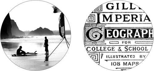
Of key importance is that both collaborators accepted that the final visual interpretation was achieved through a crafted process. Recognising the vitality of that open-ended process as a creative tool, we were seeking to transform and extend the data interpretation, not merely translate the data. Similarly, CitationHawkins (2017, p. 312) comments on the ability of art-geomorphology projects ‘to draw out the potential of art to move beyond the accurate conveying of scientific information to communicate the ambiguities and hesitancies of earth sciences to explore these landscapes as human spaces with consequences for life’. The scope for additional imagery was designed to maintain consistency across the craft work by containing new imagery within a standard format and size of circle, like oculi focusing in on particular points, while still allowing for a wide diversity of actual images and experimentation with a range of digitised source materials.
There are around 20 circles imposed over the background map and they are split into two groups. Half were sourced from original artwork or from appropriate objects and imagery. They are diverse in character, ranging from a piece of common bladderwrack seaweed that was picked up from a local beach and then dried, scanned and altered in Adobe Photoshop, to photographs and ink drawings. The other half were sourced through a deliberately collaborative strategy. The opportunity to contribute imagery that could be used as a circle image within the piece was offered to a small group of colleagues who at the time were closest to the work being carried out. For example, supervisors, colleagues and family members were approached and asked if they would like to contribute an object or image that signified a connection to a personal coastal memory, or that related to how they experienced or thought about the coast. This resulted in a very interesting and surprising diversity of objects and images.
This collaborative approach generated a wider sense of interaction and interest in the work. The use of a variety of objects and imagery, and the resulting greater sense of participation observed, both added value and created a collaborative value chain, embodied within the work. The work had a small but focused ‘community of interest’ and was able to integrate some wider points of view regarding coastal amenity use and value, for example a child's eye vision of a sunny day out.
2.2. Craft process
Risner's practice log reveals that five times as much time was spent experimenting and pursuing routes that ultimately were not followed (although they yielded useful results, techniques and creative insights) compared to the time spent producing the final craft work. This sense of resolving issues through time invested in making, often without successful results but building experience and options which were used in some way later, was common to her previous non-digital craft practice and to some extent explodes the myth that ‘push-button’ digital simplicity exists in resolved digital craft work. Complex multi-stage processes were explored for converting objects to images in a digital format, through scanning or photography, and then for altering, transferring, and combining the new digital imagery into a desired scale and format. A variety of relief output options (such as laser engraving and milling) were employed to create press moulds in a range of media. The conversion of data from one medium or format to another is never a direct translation, but is transformative, and this is an essential part of a craft process and approach.
This digital craft process resonates with a recent critical appraisal of the emerging role of technology in geomorphic science (CitationViles, 2016). ‘Thinking through doing’, as an approach to process-guided knowledge acquisition, is recognised as fundamental to craft practices, whether involving digital technologies or otherwise. The nature of the explorative activities within craft are less guided by rigidly definable final goals, and are more contingent; sensitive to the potential value of unexpected outcomes of the making process and responsive to collaborative activities as they arise. Risner's PhD draws on these detailed descriptions of practice to support her account of technepractice.
2.3. Exhibition
In our collaboration, ten final versions of the panels depicting the map and layered imagery were made in translucent porcelain and exhibited within a bespoke light box (). Both collaborators, and several of the individuals who contributed imagery, attended the private view for the 13th Appledore Visual Arts Festival exhibition. The way in which this donated imagery contributed significant value to the craft work, can be seen in the generation of interest in, and comment on, the finished work. A sense that there was a reason to talk about the content of the work was apparent (). This sense of wider involvement and ownership was very noticeably at odds with Risner's previous experience of exhibitions where work might engender aesthetic admiration but rarely gets discussed in an animated fashion. This level of discussion was directly related to Naylor's interest in using the work as a way to engage the audience with the scientific data behind the mapping. She spent several hours discussing the work with interested members of the public. A poster documenting the background to the work and providing further explanation of the significance of the data was displayed alongside for the duration of the exhibition. In this way, a sense of continuity between the aesthetic value of the work, drawing in viewers, and its underlying meaning and context, was maintained. Feedback was positive and the work has gone on to be exhibited subsequently; for example, in the Liskeard Museum exhibition entitled ‘Mineral Landscapes: a celebration of science, art and industry’ (February 2015).
3. Conclusion
From the crafts perspective, our collaboration demonstrates the interdisciplinary potential of placing craft, through digital means, in a direct conversation with other fields. The use of digital data is ubiquitous, and potential sources of data are almost unlimited. The project demonstrates that the opportunity exists for craft to make connections to audiences; for example, by acting as a conduit for interaction, communication, or for education, thereby adding value through collaborative chains.
Against a backdrop of growing formal links between arts/creative practice and science (e.g. see CitationHawkins’s (2017, pp. 307–312) account of art–geomorphology projects), our collaboration enriches this portfolio of activity. This project was fundamentally one in which science was drawn into a crafts process, and where we co-created an exhibition, rather than a more one-directional interaction where a scientist asks a crafts practitioner to help communicate their science. It also sits within a broader digital craft genre in which a number of digital craft practitioners are experimenting with alternative data sources. Jorgensen, for example, is a craftsperson who has worked with digitised hand movement data expressed in cast glass form (e.g. CitationJorgensen, 2017). Recorded sounds (CitationMann, 2017), representations of memories (CitationWallace, 2017), or audience responses to work (CitationCleverly, 2017) are just some of the variety of external information sources that have been digitised and then integrated and re-presented by well-known digital craft practitioners. The common ground of ‘data’ as digital phenomena provides a platform for interdisciplinary language and communication, and for extraordinary narrative content.
From the geomorphology perspective, without the collaboration, the scientific data would have remained accessible only to the academy through academic publication, apart from some press coverage in 2008 after the storm, and then following open access publication (CitationNaylor et al., 2016). The scientific data contain an easily understandable and fascinating narrative that was clearly of broader interest to the public, especially when Naylor was available to explain and contextualise the findings using our collaborative outputs as a visual tool to aid engagement. Exposing the mapping data to the scrutiny of a craftsperson opened up new avenues of discussion concerning the data and its meaning, and resulted in a mapping representation that Naylor felt did justice to the scientific integrity of the data and was appropriately integrated into the work.
Our conclusion is that this interdisciplinary collaboration was seen as successful on both sides and that this resulted, first and foremost, from both parties having clear and challenging objectives for the work that moved forward practice for both. In this sense, the project work acted as a ‘boundary object’ for both parties, able to represent different values and fulfil different objectives for each at the same time. We found that important aspects for us included building a relationship of trust, mutual respect and shared understanding of language, based on commitment of time, and a willingness to go forward with something novel and experimental, as an exploration. For Naylor, this project reaffirmed her strong enthusiasm for working across disciplines. She stresses that brokering relationships and ideas across disciplines is extremely satisfying, as it allows you to ‘see’ your own field from a new perspective, helps you to communicate more effectively and identify novel research questions, but she also recognises a need to relinquish some control and allow a process to unfold.
Stepping outside our own disciplines ultimately benefited us all by setting a new agenda within our work. For Naylor, an ongoing concern to place data within a wider context has led to PhD supervision of broader interdisciplinary projects and a re-positioning of her research practice. She explains how the collaboration was tremendously influential for the direction of her research activity. She has consistently had externally funded projects involving artists and makers (e.g. https://edinburghlivinglandscape.org.uk/2017/05/greening-the-grey/), and has been engaged with geomorphic science communication (e.g. www.shoreshapers.org). These creative collaborations have helped her create more effective metaphors to tell a more visually accessible story of coastal erosion risks in a changing climate. For Risner, this positive experience of collaborative academic work has led to a postdoctoral position within a broader interdisciplinary research team, looking at how digital data transfer and digital making technologies can foster creativity and public engagement with making. For both parties, therefore, this small but successful experience was a stepping stone towards a more outward orientation of research, ultimately putting them on the road towards more public engagement and potentially greater research impact. Such alignment meets with the aspirations of Research Councils UK to encourage interdisciplinary collaborative projects (CitationRCUK, 2016).
Acknowledgements
Isabelle Risner's PhD research was undertaken at Falmouth University where she acknowledges the support and collaboration provided by workshop technicians and practice experts. Larissa Naylor acknowledges support from the research computing technician (A. Cowley) and cartographer (S. Roulliard) at the University of Exeter who made the initial base maps.
Disclosure statement
No potential conflict of interest was reported by the authors.
ORCID
Isabelle J. Risner http://orcid.org/0000-0002-1408-5223
Larissa A. Naylor http://orcid.org/0000-0002-4065-2674
Additional information
Funding
References
- Adamson, G. (2013). The invention of craft. London, NY: Bloomsbury.
- Barry, A., Born, G., & Weszkalnys, G. (2008). Logics of interdisciplinarity. Economy and Society, 37(1), 20–49. doi: 10.1080/03085140701760841
- British Society for Geomorphology. (2017). What is geomorphology? Retrieved from https://geomorphology.org.uk/what-geomorphology-0
- Bunnell, K. (1998). Re: presenting making. The integration of new technology into ceramic designer-maker practice. CRiAD, Gray’s School of Art. Aberdeen: The Robert Gordon University.
- Clarke, L., Schillereff, D., & Shuttleworth, E. (2017). Communicating geomorphology: An empirical evaluation of the discipline’s impact and visibility. Earth Surface Processes and Landforms, 42, 1148–1152. doi: 10.1002/esp.4129
- Cleverly, J. (2017). Retrieved from ttps://www.jasoncleverly.com/
- Dormer, P. (Ed.). (1997). The culture of craft: Status and future. Manchester: Manchester University Press.
- Gregory, K. J., Lane, S. N., Lewin, J., Ashworth, P. J., Downs, P. W., Kirkby, M. J., & Viles, H. A. (2014). Communicating geomorphology: Global challenges for the twenty-first century. Earth Surface Processes and Landforms, 39, 476–486. doi: 10.1002/esp.3461
- Hawkins, H. (2017). Creativity. New York, NY: Routledge.
- Jorgensen, T. (2017). One Liner. Retrieved from http://onviewonline.craftscouncil.org.uk/one-liner/tavs-jorgensen/
- Livingstone, S. J., Cofaigh, C. Ó., & Evans, D. J. A. (2008). Glacial geomorphology of the central sector of the last British-Irish ice sheet. Journal of Maps, 4, 358–377. doi: 10.4113/jom.2008.1032
- Mann, G. (2017). Retrieved from http://geoffreymann.com/
- Marshall, J. (1999). The role and significance of CAD/CAM technologies in craft and designer-maker practice: with an emphasis on architectural ceramics. Cardiff: University of Wales Institute, Open University.
- McCullough, M. (1998). Abstracting craft: The practiced digital hand. Cambridge, MA: MIT Press.
- Measham, T. G. (2013). How long does social learning take? Insights from a longitudinal case study. Society & Natural Resources, 26, 1468–1477. doi: 10.1080/08941920.2013.799726
- Naylor, L. A., Stephenson, W. J., Smith, H. C. M., Way, O., Mendelssohn, J., & Cowley, A. (2016). Geomorphological control on boulder transport and coastal erosion before, during and after an extreme extra-tropical cyclone. Earth Surface Processes and Landforms, 41, 685–700. Retrieved from http://onlinelibrary.wiley.com/doi/10.1002/esp.3900/abstract;jsessionid=2F951A284AEDCBD051ED740374062249.f02t01 doi: 10.1002/esp.3900
- Newell, B. (2012). Simple models, powerful ideas: Towards effective integrative practice. Global Environmental Change, 22, 776–783. doi: 10.1016/j.gloenvcha.2012.03.006
- Ogle, R. (2008). Smart world: Breakthrough creativity and the new science of ideas. London: Marshall Cavendish.
- RCUK. Strategic priorities and spending plan 2016–20. Retrieved from http://www.rcuk.ac.uk/documents/documents/strategicprioritiesandspendingplan2016/
- Risner, I. (2013). The integration of digital technology into designer-maker practice: A study of access, attitudes and implications (PhD thesis). University of the Arts, London. Retrieved from http://ualresearchonline.arts.ac.uk/view/creators/Risner=3AIsabelle=3A=3A.html
- Sennet, R. (2008). The Craftsman. London: Allen Lane.
- Star, S., & Griesemer, J. (1989). Institutional ecology. Translations and boundary objects: Amateurs and professionals in Berkeley’s museum of vertebrate zoology. 1907–1939. Social Studies of Science, 19(3), 387–420. Sage. doi: 10.1177/030631289019003001
- Tooth, S., Viles, H. A., Dickinson, A., Dixon, S. J., Falcini, A., Griffiths, H. M., … Whalley, B. (2016). Visualizing geomorphology: Improving communication of data and concepts through engagement with the arts. Earth Surface Processes and Landforms, 41, 1793–1796. doi: 10.1002/esp.3990
- Viles, H. A. (2016). Technology and geomorphology: Are improvements in data collection techniques transforming geomorphic science? Geomorphology, 270, 121–133. doi: 10.1016/j.geomorph.2016.07.011
- Wallace, J. (2017). Retrieved from http://www.digitaljewellery.com/jaynewallace/home.html
- Yair, K. (2011). Craft & the Digital World, UK Crafts Council report. Retrieved from http://www.craftscouncil.org.uk/content/files/craft_and_the_digital_world.pdf