
 ?Mathematical formulae have been encoded as MathML and are displayed in this HTML version using MathJax in order to improve their display. Uncheck the box to turn MathJax off. This feature requires Javascript. Click on a formula to zoom.
ABSTRACT
The shallow landslides assessment is a hard task in territories featuring composite influence of natural and anthropic factors. In Liguria region (northwestern Italy), the landscape presents widespread human intervention prevalently represented by terraces. The assessment of predisposing factors in such landscape deserve a multidisciplinary approach. We implemented a classification methodology based on the Analytical Hierarchy Process. In GIS environment we overlaid several layers: (i) slope, (ii) land use, (iii) lithology, and (iv) aspect. Slope and aspect have been computed on a filtered (based on TPI) high-resolution DTM with the removal of terraces, in order to obtain the pristine slope pattern. Each spatial data was then reclassified according to the weighting procedures thus producing a landslide susceptibility map. This methodology represents a starting point for the correct assessment of shallow landslides occurrence, capable to generate a map, taking in account of the peculiar features of this extremely man-made territory.
1. Introduction
Shallow landslides constitute a widespread phenomenon in Liguria region (northwestern Italy) mostly due to the unique combination of steep slope and heavy rainfall, enhanced by human interferences.
Hillslope morphology of the Ligurian hinterland, characterized by catchments with limited extension, high relief that abrupt descent to the coastline makes it particularly susceptible to shallow landslides and flash floods (Brandolini, Faccini, Robbiano, & Terranova, Citation2008; Faccini, Luino, Sacchini, Turconi, & De Graff, Citation2015). This setting, associated with modification on land use, leads to an increase on landslides occurrence (Brandolini et al., Citation2018; Bruschi et al., Citation2013; Glade, Citation2003; Lasanta-Martínez, Vicente-Serrano, & Cuadrat-Prats, Citation2005). In this region, human intervention represented noteworthy morphogenetic impact. The current landscape is the result of a long-term land use history, arising from the extensive building of terraces, already in the Middle Ages, and their level of maintenance work over time (Brancucci & Paliaga, Citation2006; Cevasco, Pepe, & Brandolini, Citation2014; Tarolli, Preti, & Romano, Citation2014).
In this strongly human-influenced environment, with high socio-cultural heritage, the mitigation of landslides hazard become a crucial issue in risk management and in land-use planning. Landslide hazard is defined as the probability of occurrence of a potentially damaging phenomenon within a given area and in a given period of time (Varnes, Citation1984). In the Ligurian territory, due to numerous natural and human-induced environmental factors (e.g. topography, geology, land cover), the assessment of the shallow landslides occurrence it is not a simple issue. The use of landslide susceptibility maps gives information on the potential areas that are landslide-prone, identifying the most probable initiation areas, on the basis of local terrain condition (Brabb, Citation1984; Corominas et al., Citation2014), and states the degree to which a territory can be affected by future slope failure (Guzzetti, Carrara, Cardinali, & Reichenbach, Citation1999). Furthermore, in some cases, landslide susceptibility zonation is extended in order to cover areas from which landslides may travel on to or regress into the area being zoned (Fell et al., Citation2008).
Our study aims to assess the landslide susceptibility of a hilly-mountainous highly human-influenced areas, using a semi-quantitative index-based method. This method is the Analytic Hierarchy Process (AHP), developed by Saaty (Citation1977), able to organize and analyze multi-criteria decisions. This is highly useful in landslide susceptibility analysis that depends on a multiple-knowledge of all the causative factors in landslides occurrence (Kayastha, Dhital, & De Smedt, Citation2013; Thanh & Smedt, Citation2012; Yalcin, Citation2008).
At the base of landslides susceptibility computation, there is the selection of thematic variables. In literature, various factors are employed, considering diverse geo-lithological, morphological, land use aspects. We specifically take care of morphological variables considered relevant in susceptibility model assessment (Reichenbach et al., Citation2018), and in our case affected by human impact. The Ligurian landscape brings with it widespread anthropic geometrical elements represented by terraces. These features strongly modify the natural morphometric aspect, constituting a forcing able to create a misleading effect affecting the topographic variables. High-resolution Digital Terrain Model (HR-DTM) usage are highly recommended (Corominas et al., Citation2014), since the smaller a cellsize is, the more have enough resolution to support slope stability characterization and provide adequate quality on the input data. The availability of an HR-DTM should be considered an added value, but poses also new issues relative to the landslide susceptibility map computation concerning the proper exploitation of such dataset. Conversely, previous susceptibility models have been generated using only medium or low-resolution DTMs, approximating the effective terrain profile (Persichillo et al., Citation2016). In a complex environment as a terraced area (Tarolli, Calligaro, Cazorzi, & Dalla Fontana, Citation2013), the effectiveness of an HR-DTM become evident. In this paper, we leverage on a very HR-DTM with 25 cm cellsize available in an area strongly human modified in last centuries with the construction of anthropic terraces. To properly consider the effect of terraces on morphometric aspect definition, we developed and tested an ad hoc filtering procedure based on the TPI index (Tagil & Jenness, Citation2008). The presented methodology is based on the use of open source Geographic Information System (e.g. QGIS), and statistical programming languages (e.g. R), which facilitate the computation of these variables and the generation of susceptibility maps (Carrara, Guzzetti, Cardinali, & Reichenbach, Citation1999; Chacon, Irigaray, Fernández, & Hamdouni, Citation2006; Van Westen, Citation2004).
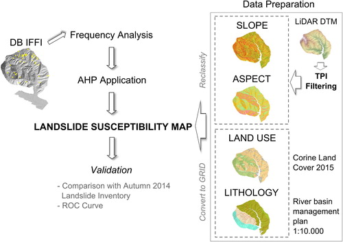
The considered case study is a shallow landslides prone area of the Liguria region (northwestern Italy), corresponding to a small coastal basin named Rupinaro catchment. During the autumn 2014, this area was affected by a series of intense rainfall events, causing numerous shallow landslides inventoried in Giordan, Cignetti, Baldo, and Godone (Citation2017), leveraging a very high-resolution digital terrain model from LiDAR survey. The availability of an adequate dataset of previous landslides and the event map related to the flood of 2014 make this basin a perfect test site for the application of the proposed methodology. In this work, we operated as follow: (i) analysis of the causative factors leveraging on the HR-DTM and on-field survey observation; (ii) computation of frequency analysis of the regional inventoried landslide (Trigila, Iadanza, & Spizzichino, Citation2008) in order to define the relation between the selected variables and landslides occurrence; (iii) implementation of a morphometric filtering of the DTM by the TPI method, in order to estimate the higher loyal landscape pattern, taking account of anthropic terraces; (iv) application of the AHP method computing the weights for each variable and relative classes, and finally (v) comparison and validation of the obtained susceptible map with previous inventoried landslides.
2. Study area
The Rupinaro catchment is a small coastal basin (11 km2) of the Liguria region (northwestern Italy), within Chiavari municipality. The topographic relief of the catchment ranges from 547 m (Mt. Anchetta) elevation above sea level (). The whole of the landscape is occupied by hills and mountains with a very steep slope, surrounding restricted flat areas. Generally, high acclivity and the proximity to the coastline reflect the typical tectonic setting of the Ligurian Apennines, with short channels with low-hydrographic order and high erosive action (Brancucci & Paliaga, Citation2006). Slope never exceed 45 –50 except for limited sectors, and aspect is prevalently south-southwest faces. Land use reflects a deeply human-influenced landscape, primarily represented by centuries-old anthropic terraces, entailing the creation of flat areas for farming. These structures consist of dry-stone walls, covering about 40% of the catchment (Godone, Giordan, & Baldo, Citation2018).
Figure 1. Relief terrain of the Rupinaro catchment, located in the eastern Liguria region (northwestern Italy): (a) aspect and (b) slope morphometric parameters.
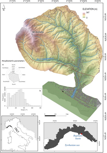
From a geological point of view, the study area is entirely within the Northern Apennines flysch succession (Marroni et al., Citation2002; Molli et al., Citation2010). The outcrop geological formation passes through the Mt. Antola Unit, constitute by the Mt. Antola Limenstones, to the Mt. Gottero Unit, constitute by the Slates of Mt. Verzi, the Manganese rich Shales and Palombini Clays. The Mt. Antola Limestones is localized in the western part of the basin, along the right side of the Rio Campodonico, tributary of the Rupinaro Stream. This unit prevalently consists of a turbiditic succession of marly limestone, and subordinated shales and slate (Scholle, Citation1971). The Manganese rich Shales, together with the Slates of Mt. Verzi, lie in the majority of the catchment. The Manganese rich Shales prevalently outcrops along the main stream axis, and consists of dark shales with intercalation of thick siltstones and calcarenites. The Slates of Mt. Verzi mainly lie in the left side of the Rio Campodonico, consisting of dark slates and marl (Marroni, Della Croce, & Meccheri, Citation1988). In the eastern sector of the basin, outcrops the Palombini Clay of the Giacopiane Lake, composed by an alternation of shales and siliceous limestones (Van Wamel, Citation1987).
2.1. Thematic data
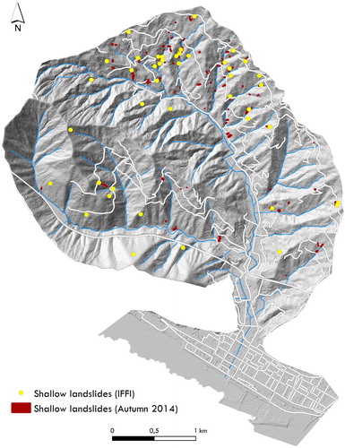
For landslides susceptibility map generation, one of the most important element is the availability of past landslides inventory. For the Rupinaro basin, two different inventories are available and employed in this work; (i) the National Landslide Inventory, achieved in the IFFI project (Trigila et al., Citation2008); (ii) the landslides inventory of the autumn 2014 rainfall event (Giordan et al., Citation2017).
The landslides inventoried in IFFI for the Rupinaro basin are in total 43, constituted by rainfall-induced landslides of limited size. Relative to the landslides inventoried in 2014, the study area has been hit by a series of rainstorm events occurred during the autumn of 2014 (Cevasco, Pepe, Avanzi, & Giannecchini, Citation2015; Silvestro, Rebora, Giannoni, Cavallo, & Ferraris, Citation2016). Specifically, in the 9–13th November, the Rupinaro catchment was affected by a prolonged rainfall with local rainstorm events, up to 100 mm per 3 h. The intense and prolonged rainfall generated the Rupinaro Stream flooding, triggered many shallow landslides and causing considerable damages and two casualties. After rainfall events, an helicopterborne LiDAR survey, coupled to photogrammetric acquisition of the damaged area was carried out by CNR IRPI.
The LiDAR data provided a means to identify all the rainfall-induced landslides, by exploiting its derivative products. The occurred phenomena have been mapped by a visual analysis methodology, employed combing high-resolution Digital Terrain Model (HR-DTM) and orthoimages (Giordan et al., Citation2017). Simultaneously, in the post-event phase, a field survey has been executed to define the main characteristics of the occurred phenomena. A total of 110 landslides have been inventoried (). Landslides were classified according to Cruden and Varnes (Citation1996). All the phenomena correspond to shallow landslides, including soil slips, debris flows and debris avalanches, with size varying from less than 10 m2 to more than 1000 m2.
Figure 2. Inventory map of the IFFI (Trigila et al., Citation2008) and autumn of 2014 rainfall-induced landslides, affecting the Rupinaro catchment. The shaded relief derived from the high-resolution DTM obtained from the post-event LiDAR survey.
The LiDAR survey of 2014 was planned and realized considering the possibility to acquire a high-resolution dataset that could be used both for landslides mapping, and for a more detailed analysis of the anthropic terraces and slope instability relationship. For this reason the survey was performed acquiring high-density points () in a period of the year when coverage of vegetation was limited (Giordan et al., Citation2017; Godone et al., Citation2018).
Table 1. LiDAR survey parameters.
3. Methods
The methodology for landslide susceptibility map generation is structured according to the workflow showed in . The methodology is structured in three phases:
Figure 3. Scheme of the adopted methodology.
-
definition of variables influencing shallow landslides initiation;
-
data preparation;
-
analytical Hierarchy Process application.
3.1. Considered variables for landslide susceptibility estimation
An analysis of the causal factor is performed to define the main variables that influence the shallow landslides triggering in the study area. The selection of the parameters that influence landslides in susceptibility mapping do not have general guidelines. Usually, the causal factors selection is highly dependent on the characteristic of the study area and data availability. We based the variables selection on a comprehensive bibliography research, added to LiDAR data processing and field campaign carried out after the autumn 2014 rainfall events. Many authors, focusing their studies on different area among the Liguria region, analyzed the relationship between rainfall-induced landslides and factors such as land use, geology, soil properties, slope (Cevasco et al., Citation2014; Crosta, Dal Negro, & Frattini, Citation2003). In our case most relevant are the variables derived from HR-DTM that have a significant degree of affinity with landslides (Giordan et al., Citation2017), taking also into consideration the presence of terraces, such as (i) slope; (ii) aspect; (iii) land use, and (iv) lithology.
3.2. Data preparation
The availability of HR-DTM allowed to work with a detailed representation of the studied area. Morphometric and topographic layers are derived from the described HR-DTM, by the employment of GIS tools. Taking into account the anthropic variable of this area, an ad hoc filtering procedure is created, based on the TPI index. Instead, the geological and land use maps are derived from the general land-use plan (Regione Liguria, Citation2017) and the web-portal of the Liguria region (Regione Liguria, Citation2016) both at scale 1:10.000.
In parallel, we carry out a frequency analysis of the inventoried landslides, within the National Landslide Inventory (IFFI, Trigila et al., Citation2008) in order to analyze the relationships between occurred landslides respect to the considered variables for landslide susceptibility computation. This step intends to strengthen the AHP usage, particularly in the allocation of the weights of each considered factors. The availability of two different datasets of landslides inventory (i.e. IFFI and Autumn 2014 events) are useful for the calibration (IFFI) and validation (Autumn 2014 events) of the presented susceptibility model.
3.2.1. TPI index-based filtering process
During data preparation, we operate a filtering on the HR-DTM, before computing slope and aspect layers. Several published researches have estimated the susceptibility map based on a low-resolution or re-sampled DTM (e.g. 5 m/10 m resolution) and from already existing topographic database (Ayalew & Yamagishi, Citation2005; Lee, Ryu, Won, & Park, Citation2004; Persichillo et al., Citation2016). Using this approach, relevant information of the ground pattern could be lost, particularly in a strong man-made modified landscape as in the case study. In our case, the HR-DTM clearly depicts the topographic pattern. Also, the anthropic terraces (average height of walls = 2 m), which cover an area of about 40% of the Rupinaro basin (Godone et al., Citation2018), are visible. It is important to note that shallow landslides commonly have a failure surface, which arises within soil or in correspondence of soil-bedrock interface (Beguería, Citation2006; Borrelli, Ciurleo, & Gullà, Citation2018). On the widespread terraced landscape, as the Rupinaro one, field observations highlight how shallow landslides mainly occurred in correspondence of the lower portion of the dry-stone walls. Considering, both theory and field observation, we decide to remove these anthropic features, by DTM filtering, in order to ensure, as far as possible, a realistic detection of landslide-prone areas. The Topographic Position Index (TPI) is computed to spot ridges (positive TPI values) and valley (negative TPI values) (Tagil & Jenness, Citation2008); in our case study, to spot wall bases and tops. The obtained raster layer is then queried by extracting only the minimum value (< 1th percentile), with the aim to pointing out riverbeds and terraces wall bases. The filtered layer is then employed as a mask to extract DTM cells intersecting the described land features and interpolated again in a terrace free DTM.
3.2.2. Slope and aspect
Topographic information have a relevant role in landslide hazard analysis. In particular, slope represents one of the most relevant factors in shallow landslide occurrence (Lee & Min, Citation2001). Considering that the slope factor is directly related to the landslides, it is frequently used in preparing landslide susceptibility maps, by applying a variable number in slope gradient subdivision (Bui, Lofman, Revhaug, & Dick, Citation2011; Calvello & Ciurleo, Citation2016; Clerici, Perego, Tellini, & Vescovi, Citation2002; Wu et al., Citation2016; Yalcin, Citation2008).
The availability of HR-DTM represents a useful instrument to derive these information. In the study area, the slope is affected by a geometric forcing constituted by the dry-stone walls of anthropic terraces. The availability of very HR-DTM points out clearly the presence of these features. The distribution of slope classes is strongly influenced by the presence of these elements that can affect the result of the model. By the TPI filtering, we obtain a terrain profile filtered by these geometric elements, by removing the disturbance produced by terraces. Totally, five slope classes have been set up for the Rupinaro catchment case study: (i) less than 15; (ii) 15–25
; (iii) 25–35
; (iv) 35–45
; (v) more than 45
.
Aspect is recognized as one of landslide conditioning factors and generally considered in the assessment of landslides susceptibility (Dai, Lee, & Ngai, Citation2002; Guzzetti et al., Citation1999). It has an effect on solar and rainfall exposure, thereafter on soil moisture and degree of saturation, which may influence the distribution and density of landslides occurrence (Eger & Hweitt, Citation2008; Yalcin, Citation2008). In literature, a linkage between aspect angle and soil formation and evolution has been observed, with a major correspondence in south-facing slopes (Sidari, Ronzello, Vecchio, & Muscolo, Citation2008; Stanchi, Freppaz, Godone, & Zanini, Citation2013). For this reason, we considered three aspect classes divide in north, south and east/west orientation indistinctly.
3.2.3. Land use
Land use, together with morphological factor, strongly conditioned rainfall-induced landslides initiation (Dai, Lee, Tham, Ng, & Shum, Citation2004; Galve, Cevasco, Brandolini, & Soldati, Citation2015). In accordance with the literature (Dai, Lee, Li, & Xu, Citation2001; Greenway, Citation1987), an improvement in slope stability, in terms of vegetation cover, should be linked to deep-rooting plants and to a soil moisture reduction by evapotranspiration.
Land use map of the Rupinaro catchment has derived from the vector data available from the geoportal of Liguria region (Regione Liguria, Citation2016), at 1:10.000 scale. Three classes of land use were generated for this area. We grouped all the urbanized areas, inclusive of road and rail network, industrial, commercial and public unit, in a unique class ‘Artificial areas’. All the cultivated sectors have been grouped in the class ‘Agricultural areas’, consisted primarily of ‘Non-irrigated arable land’, ‘Pasture’, ‘Olive groves’ and ‘Complex cultivation patterns’. Instead, all those sectors with scattered vegetation and scrubs and wooded sectors have been included in the class ‘Forest’.
3.2.4. Lithology
Lithology plays a relevant role in slope stability. As already described, bedrock of the Rupinaro catchment mainly belong to the Gottero Unit, and in the southeastern part to the Antola Unit. Lithological data were available by the general land-use plan (Regione Liguria, Citation2017), at 1:10.000 scale. At the basin scale, more than half territory belong to an impervious bedrock mainly consisting of shales and/or shale associated to marl. Instead a bedrock permeable for fracturing has been recognized in the marginal southeast portion of the study area (Regione Liguria, Citation2017). Three classes have been set: (i) shGOT, corresponding to Manganese rich Shales and Palombini Clay, impervious bedrock, (ii) shmGOT, corresponding to Slates Mt. Verzi, impervious bedrock and (iii) mlFMA, corresponding to Mt. Antola Limestones permeable for fracturing.
3.3. Analytic hierarchy process
The data preparation allows to extract the all considered variables in a grid format, in order to apply the Analytic Hierarchy Process (AHP).
The application of this method requires the division of a composite problem and the organization of its factors in a hierarchic order. Once the hierarchy is structured, a numerical value () is associated to the considered elements. These numerical values are based on subjective judgments on the relative importance of each factor. Therefore, the judgments are synthesized to determine the priorities to be assigned to these factors. Finally, a pair-wise comparison matrix is set up, and the normalized principal eigenvector is computed giving the weight of each factor (Saaty & Vargas, Citation2012).
Table 2. Scale of preference between two parameters in AHP (Saaty, Citation1977).
In the proposed methodology we computed a frequency analysis to collect information concerning the relationship between occurred shallow landslides, as reported in landslide national inventory (Trigila et al., Citation2008) and the selected causal factors of the Rupinaro catchment. This procedure allows to allocate weights to the various conditioning factor classes, for AHP, in a less subjective manner.
In this study, such as in other previous works (Thanh & Smedt, Citation2012; Yalcin, Citation2008; Yalcin, Reis, Aydinoglu & Yomralioglu, Citation2011), the AHP approach is applied to assign weights to causative factors by pair-wise comparison and to classes within each factor, too. The comparison matrix of the four identified causative factors is reported in , together with their respective comparison matrix. All the pair-wise comparison matrices were structured ranking the established items with respect to their impact on slope instability. The normalized principal eigenvector matrix of each factor is calculated by a statistical opens source environment (R Development Core Team , Citation2011) and reported in . In order to verify the consistency of the weights and ratings, the consistency index (CI) was applied, calculated by (Saaty, Citation2000)(1)
(1) where
is the largest eigenvalue and N is its size, corresponding to the number of parameters. Next, the consistency index is compared to a random consistency index RI. The RI values were reported in Saaty (Citation1977) as a function of N , and allows to calculate a consistency ratio CR, defined as
(2)
(2) When the consistency ratio is larger than 10% the subjective judgment in the pair-wise comparison is inconsistent and needs to be revised.
Table 3. Pair-wise comparison matrix and normalized principal eigenvector for landslide causative factors and for the classes within each factor, as required for applying the AHP method.
In view of factor weights determined by the AHP method a landslide susceptibility map was generated. We operated in GIS environment by the reclassification and rasterization of all the considered thematic layers. Applying a procedure based on the weighted linear sum (WLS), the combination of the causative factors and their classes was obtained, defining a landslide susceptibility index (LSI)(3)
(3) where
is the weight value of causative factor j,
the weight value of class i in causative factor j, and N the number of considered causative factors.
4. Results and validation
By applying the AHP method, we obtained the Landslides Susceptibility map of the Rupinaro basin (Main Map). The pair-wise comparison matrix was structured using four causative factors ranked in term of their impact on slope instability, also justified by the frequency analysis based on the IFFI national inventory analysis (Trigila et al., Citation2008). The normalized principal eigenvector of each comparison matrix portrays the presences applied in the hierarchic order, both between causative factors and between the classes of each causative factors (). For the study area, the slope factor corresponds to the most relevant considered variable getting the highest weight of 0.52, followed by the land use factor weighting 0.26. reports the Consistency Ration (CR), calculated on the basis of the relative values of Consistency Index (CI) and Random consistency index (RI). These parameters confirm the consistency of the weights and rating of each considered causative factors. The resulting Landslide Susceptibility map presents LSI value ranging from 0.06 to 0.56. LSI values are then classified by manual classification according to Oztekin and Topal (Citation2005) (). Totally four classes resulting: (i) low, (ii) medium, (iii) high, and (iv) very high. The ‘high’ LSI values cover most of the analyzed territory (43%), principally distributed in the northern and eastern portions of the basin. ‘Moderate’ values occupy the 28% of the Rupinaro basin, whereas the ‘very high’ and ‘low’ classes respectively have 12.5% and 16.5% of the basin ((a)).
Figure 4. Landslide susceptibility zonation map of the Rupinaro catchment; dark gray polygons correspond to the shallow landslides occurred during the autumn 2014 rainfall events. (a) Histogram of percentage values of basin areas and landslide areas in the four susceptibility classes.
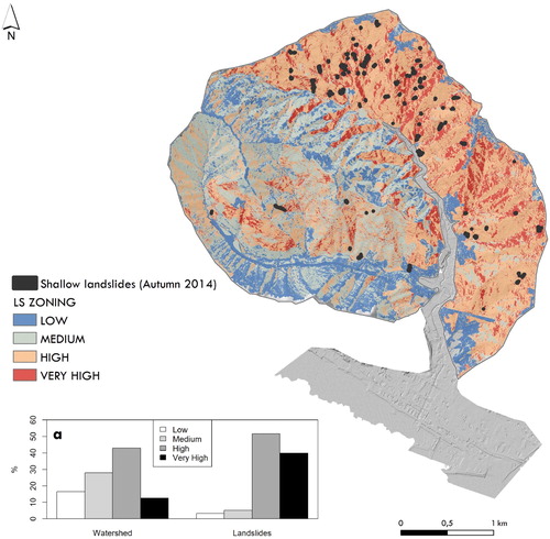
Table 4. Consistency index (CI), random consistency index (RI) and consistency ratio (CR) values for the causative factors considered.
In the case of Rupinaro catchment, consideration has been done to the long-term history of human impacts, primarily represented by anthropic terraces. These structures are widely distributed in the Rupinaro catchment (Godone et al., Citation2018), constituting a sensitive element in slope stability, mainly in respect of their level of maintenance (Arnáez, Lana-Renault, Lasanta, Ruiz-Flaño, & Castroviejo, Citation2015; García-Ruiz & Lana-Renault, Citation2011; Koulouri & Giourga, Citation2007; Tarolli et al., Citation2014). This landscape brings with it anthropic geometrical elements, with an average size of 2 m in height and some tens of meters in length. In this way, those features deeply modify the natural terrain profile, constituting a forcing able to create a misleading effect in landslides susceptibility computation. As highlighted in literature (Corominas et al., Citation2014; Reichenbach et al., Citation2018), HR-DTM usage in morphometric variables computation allows to improve the susceptibility map generation. Even more in the case of the deeply human affected profile terrain of the Rupinaro catchment, distinguishing and extrapolating the terraces geometry. Thanks to the HR-DTM availability, and applying the TPI filtering, we remove the disturbance, due to the dry-stone walls of the anthropic terraces, on slope and aspect computation obtaining a homogeneous layer, that describes a terrain without terraces.
A verification of the obtained result has been done on the basis of prior landslides inventory. Specifically, we employed the available data relative to the landslides inventory of the autumn 2014 rainfall events (Giordan et al., Citation2017). The mapped landslides correspond to 110 shallow landslides. Considering the source area, the inventoried landslides prevalently occurred in the slope classes of 25 –35 and 35 –45
, respectively the 41% and the 28%, presenting east–west and south exposure. The highest number of landslide occurred on agricultural areas (more than 90%), particularly in correspondence of olive groves, in connection with an impervious bedrock mainly consisting of shales and shales associated to marl. In the Rupinaro basin, this crop typically lies with terraced areas. By field observation and DTM derivative products analysis, we have found that, in most cases (approximately 80%), the source area of the inventoried landslides fells in correspondence of the dry-stone walls bases. The overall quality of the landslide susceptibility map is confirmed by the inventoried landslides areas distribution in the four respective LSI classes ((a)). Observing landslides distribution the 52% fall within ‘high’ susceptibility class and the 40% in the ‘very high’ class, prevalently in correspondence of agricultural areas, specifically olive groves, with a medium to high slope gradient. This result correctly predicts all known landslides inventoried for the autumn 2014 rainfall events.
In those areas with ‘high’ and ‘very high’ susceptibility that fall in correspondence of high vegetated areas, e.g. forested sectors, a limited number of shallow landslides have been observed. The landslides distributions could be related to the degree of slope degradation, and specifically to the level of terraced slope abandonment and recolonization by vegetation of these anthropic features. In fact, it is important to note that also forested sectors have a terraced slope, which are characterized by a high degree of vegetation cover such as to ensure a major slope stability. As demonstrated by Brandolini et al. (Citation2017), a relationship between time of terraces abandonment, slope degradation and vegetation growth has been observed in other area of the Liguria Region, based on a detailed field campaign to define the degree of agricultural land abandonment. In our case, instead, the implemented methodology offers a procedure taking advantage of immediately available and validated datasets (e.g. National Landslide Inventory; regional land use and lithology data), associated to a high-resolution DTM capable to finely describe also terraced landscape, as the considered one. In this way, we want to provide a prompt methodology, easily applicable during emergency, to define landslide susceptibility distribution, and easily replicable in cases in which a new LiDAR survey become available, avoiding a time-consuming detailed field survey that can be performed at a later stage.
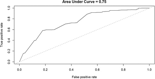
Additional validation of the Landslide Susceptibility map has been done applying the Relative Operating Characteristic (ROC) curve. The success rate is computed on the basis of a comparison between the landslide grid cells (Autumn 2014 rainfall events, ) and the rainfall-induced landslides susceptibility grid (Chung & Fabbir, Citation2003). We obtain a success rate of 75% ().
Figure 5. ROC curve computed on the basis of a comparison between landslide grid cells and landslides susceptibility grid.
5. Conclusion
The landslide susceptibility map assessment aimed at defining the potentially unstable areas, constitute a fundamental step for a more efficient land use planning and for hazard management. Various causes of landslides occurrence make the assessment of their natural and man-made predisposing factors a multidisciplinary procedure. This becomes even more evident when looking at territories extremely modified by human activity. On that basis, this study has been focused on a small coastal river basin, the Rupinaro catchment (eastern Liguria, Italy) characterized by a deeply human-influenced landscape, mainly represented by centuries-old agricultural anthropic terraces constitute by dry-stone walls. Remarkable interaction and mixing of natural and man-made factors, affecting slope instability, make this area a unique cultural and natural heritage.
The methodology proposed in this paper uses the AHP approach for shallow landslide susceptibility map generation. The causal factors definition is primarily based on field observation and in the light of experiences, strengthened by a frequency analysis computation based on the available dataset of the National Landslide Inventory. Moreover, we have exploited the available HR-DTM, acquired by helicopterborne LiDAR, to obtain a qualitative and quantitative data of morphological and man-made features like terraces. We developed a filtering procedure able to return a profile terrain without the geometric elements constituted by terraces. By this way, a robust morphometric parameters computation is ensured for the landslide susceptibility map definition.
The results display that most of the analyzed territory falls within very high and high classes of susceptibility (> 50%), predicting the 92% of the landslides exploited in the validation phase. Moreover, the application of ROC curve shows that the overall success rate of the shallow landslide susceptibility map is 75%. The obtained landslide susceptibility map can be a useful source for the management of high human-influenced territory, taking advantage of HR-DTM and its properly exploitation. Our procedure attempts to resolve the disturbing effect due to terraces, considered as a geometric element widespread throughout the whole territory, in order to clearly depict the pristine topographic pattern and define the most susceptible areas as realistic as possible. The proposed methodology, although provided encouraging results, will be improved in order to better represent critical areas such as very steep terraced study area.
Software
The shallow landslide susceptibility map was developed by the employment of several GIS tools, available in ArcGIS 10.2 (and following releases) and R 3.3 (and following releases).
SusceptibilityMap_REV2_FEB19.pdf
Download PDF (37.9 MB)Acknowledgments
The authors acknowledge Marco Baldo for LiDAR data processing. LiDAR survey has been funded by Liguria Region.
Disclosure statement
No potential conflict of interest was reported by the authors.
ORCID
Martina Cignetti http://orcid.org/0000-0002-4414-4386
Danilo Godone http://orcid.org/0000-0003-1455-6862
Daniele Giordan http://orcid.org/0000-0003-0136-2436
Related Research Data
References
- Arnáez, J. , Lana-Renault, N. , Lasanta, T. , Ruiz-Flaño, P. , & Castroviejo, J. (2015, May). Effects of farming terraces on hydrological and geomorphological processes. A Review CATENA , 128 , 122–134. S0341816215000351 doi: 10.1016/j.catena.2015.01.021
- Ayalew, L. , & Yamagishi, H. (2005, February). The application of GIS-based logistic regression for landslide susceptibility mapping in the Kakuda-Yahiko mountains. Central Japan Geomorphology , 65 (1), 15–31. S0169555X04001631 doi: 10.1016/j.geomorph.2004.06.010
- Beguería, S. (2006, March). Changes in land cover and shallow landslide activity: A case study in the Spanish Pyrenees. Geomorphology , 74 (1–4), 196–206. S0169555X05002692 doi: 10.1016/j.geomorph.2005.07.018
- Borrelli, L. , Ciurleo, M. , & Gullà, G. (2018). Shallow landslide susceptibility assessment in granitic rocks using GIS-based statistical methods: The contribution of the weathering grade map. Landslides , 15 (6), 1127–1142. doi: 10.1007/s10346-018-0947-7
- Brabb, E. E. (1984). Innovative approaches to landslide hazard and risk mapping. Publisher not identified.
- Brancucci, G. , & Paliaga, G. (2006). The hazard assessment in a terraced landscape: Preliminary result of the Liguria (Italy) case study. Geohazards. Engineering conferences international symposium series, June (pp. 18–21).
- Brandolini, P. , Cevasco, A. , Capolongo, D. , Pepe, G. , Lovergine, F. , & M. Del Monte (2017, January). Response of terraced slopes to a very intense rainfall event and relationships with land abandonment: A case study from Cinque Terre (Italy). Land Degrad. Develop. n/a–n/a. Retrieved 2017-04-05, from http://onlinelibrary.wiley.com/doi/10.1002/ldr.2672/abstract .
- Brandolini, P. , Cevasco, A. , Capolongo, D. , Pepe, G. , Lovergine, F. , & Monte, M. D. (2018, March). Response of terraced slopes to a very intense rainfall event and relationships with land abandonment: A case study from Cinque Terre (Italy). Land Degradation and Development , 29 (3), 630–642. doi: 10.1002/ldr.2672
- Brandolini, P. , Faccini, F. , Robbiano, A. , & Terranova, R. (2008). Relationship between flood hazards and geomorphology applied to land planning in the upper Aveto Valley: (Liguria, Italy). Comitato glaciologico italiano.
- Bruschi, V. M. , Bonachea, J. , Remondo, J. , Gómez-Arozamena, J. , Rivas, V. , Barbieri, M. , & Cendrero, A. (2013, August). Land management versus natural factors in land instability: Some examples in Northern Spain. Environmental Management , 52 (2), 398–416. doi: 10.1007/s00267-013-0108-7
- Bui, D. T. , Lofman, O. , Revhaug, I. , & Dick, O. (2011). Landslide susceptibility analysis in the Hoa Binh province of Vietnam using statistical index and logistic regression. Natural Hazards , 59 (3), 1413. doi: 10.1007/s11069-011-9844-2
- Calvello, M. , & Ciurleo, M. (2016). Optimal use of thematic maps for landslide susceptibility assessment by means of statistical analyses: Case study of shallow landslides in fine-grained soils. Landslides and engineered slopes. Experience, theory and practice (pp. 537–544). Florida, US: CRC Press.
- Carrara, A. , Guzzetti, F. , Cardinali, M. , & Reichenbach, P. (1999, November). Use of GIS technology in the prediction and monitoring of landslide hazard. Natural Hazards , 20 (2–3), 117–135. doi: 10.1023/A:1008097111310
- Cevasco, A. , Pepe, G. , Avanzi, G. D. , & Giannecchini, R. (2015). A study on the 10 November 2014 intense rainfall and the related landslides in the lower Lavagna valley (eastern Liguria). Rendiconti online Società Geologica Italiana , 35 , 66–69. doi: 10.3301/ROL.2015.65
- Cevasco, A. , Pepe, G. , & Brandolini, P. (2014). The influences of geological and land use settings on shallow landslides triggered by an intense rainfall event in a coastal terraced environment. Bulletin of Engineering Geology and the Environment , 73 (3), 859–875. doi: 10.1007/s10064-013-0544-x
- Chacon, J. , Irigaray, C. , Fernández, T. , & Hamdouni, R. E. (2006, December). Engineering geology maps: Landslides and geographical information systems. Bulletin of Engineering Geology and the Environment , 65 (4), 341–411. doi: 10.1007/s10064-006-0064-z
- Chung, C. J. F. , & Fabbri, A. G. (2003, November). Validation of spatial prediction models for landslide hazard mapping. Natural Hazards , 30 (3), 451–472. doi: 10.1023/B:NHAZ.0000007172.62651.2b
- Clerici, A. , Perego, S. , Tellini, C. , & Vescovi, P. (2002). A procedure for landslide susceptibility zonation by the conditional analysis method. Geomorphology , 48 (4), 349–364. doi: 10.1016/S0169-555X(02)00079-X
- Corominas, J. , Westen, C. v. , Frattini, P. , Cascini, L. , Malet, J. P. , Fotopoulou, S. , & Smith, J. T. (2014, May). Recommendations for the quantitative analysis of landslide risk. Bulletin of Engineering Geology and the Environment , 73 (2), 209–263. 10.1007/s10064-013-0538-8
- Crosta, G. B. , Dal Negro, P. , & Frattini, P. (2003). Soil slips and debris flows on terraced slopes. Natural Hazards and Earth System Science , 3 (1/2), 31–42. doi: 10.5194/nhess-3-31-2003
- Cruden, D. , & Varnes, D. (1996). Landslides types and processes. In A. K. Turner & R. L. Schuster (Eds.) Landslides: Investigation and mitigation (pp. 36–75). Washington, D.C.: National Academy Press.
- Dai, F. C. , Lee, C. F. , Li, J. , & Xu, Z. W. (2001, January). Assessment of landslide susceptibility on the natural terrain of Lantau Island, Hong Kong. Environmental Geology , 40 (3), 381–391. doi: 10.1007/s002540000163
- Dai, F. C. , Lee, C. F. , & Ngai, Y. Y. (2002, April). Landslide risk assessment and management: An overview. Engineering Geology , 64 (1), 65–87. S001379520100093X doi: 10.1016/S0013-7952(01)00093-X
- Dai, F. C. , Lee, C. F. , Tham, L. G. , Ng, K. C. , & Shum, W. L. (2004, December). Logistic regression modelling of storm-induced shallow landsliding in time and space on natural terrain of Lantau Island, Hong Kong. Bulletin of Engineering Geology and the Environment , 63 (4), 315–327. doi: 10.1007/s10064-004-0245-6
- Eger, A. , & Hewitt, A. (2008, November). Soils and their relationship to aspect and vegetation history in the eastern Southern Alps, Canterbury High Country, South Island, New Zealand. CATENA , 75 (3), 297–307. S0341816208001136 doi: 10.1016/j.catena.2008.07.008
- Faccini, F. , Luino, F. , Sacchini, A. , Turconi, L. , & De Graff, J. V. (2015, December). Geohydrological hazards and urban development in the Mediterranean area: An example from Genoa (Liguria, Italy). Natural Hazards and Earth System Sciences , 15 (12), 2631–2652. 15/2631/2015/ doi: 10.5194/nhess-15-2631-2015
- Fell, R. , Corominas, J. , Bonnard, C. , Cascini, L. , Leroi, E. , & Savage, W. Z. (2008). Guidelines for landslide susceptibility, hazard and risk zoning for land-use planning. Engineering Geology , 102 (3), 99–111. doi: 10.1016/j.enggeo.2008.03.014
- Galve, J. P. , Cevasco, A. , Brandolini, P. , & Soldati, M. (2015, February). Assessment of shallow landslide risk mitigation measures based on land use planning through probabilistic modelling. Landslides , 12 (1), 101–114. doi: 10.1007/s10346-014-0478-9
- García-Ruiz, J. M. , & Lana-Renault, N. (2011, March). Hydrological and erosive consequences of farmland abandonment in Europe, with special reference to the Mediterranean region – a review. Agriculture, Ecosystems and Environment , 140 (3–4), 317–338. S0167880911000041 doi: 10.1016/j.agee.2011.01.003
- Giordan, D. , Cignetti, M. , Baldo, M. , & Godone, D. (2017, December). Relationship between man-made environment and slope stability: The case of 2014 rainfall events in the terraced landscape of the Liguria region (northwestern Italy). Geomatics, Natural Hazards and Risk , 8 (2), 1833–1852. doi: 10.1080/19475705.2017.1391129
- Glade, T. (2003, April). Landslide occurrence as a response to land use change: A review of evidence from New Zealand. CATENA , 51 (3–4), 297–314. S0341816202001704 doi: 10.1016/S0341-8162(02)00170-4
- Godone, D. , Giordan, D. , & Baldo, M. (2018). Rapid mapping application of vegetated terraces based on high resolution airborne lidar. Geomatics, Natural Hazards and Risk , 9 (1), 970–985. doi: 10.1080/19475705.2018.1478893
- Greenway, D. (1987). Vegetation and slope stability. In M. G. Anderson & K. S. Richards (Eds.) Slope stability: Geotechnical engineering and geomorphology (pp. 187–230). Chichester, UK : John Wiley and Sons.
- Guzzetti, F. , Carrara, A. , Cardinali, M. , & Reichenbach, P. (1999, December). Landslide hazard evaluation: A review of current techniques and their application in a multi-scale study, Central Italy. Geomorphology , 31 (1–4), 181–216. S0169555X99000781 doi: 10.1016/S0169-555X(99)00078-1
- Kayastha, P. , Dhital, M. R. , & De Smedt, F. (2013, March). Application of the analytical hierarchy process (AHP) for landslide susceptibility mapping: A case study from the Tinau Watershed, West Nepal. Computers and Geosciences , 52 , 398–408. S0098300412003731 doi: 10.1016/j.cageo.2012.11.003
- Koulouri, M. , & Giourga, C. (2007, April). Land abandonment and slope gradient as key factors of soil erosion in Mediterranean terraced lands. CATENA , 69 (3), 274–281. S0341816206001482 doi: 10.1016/j.catena.2006.07.001
- Lasanta-Martínez, T. , Vicente-Serrano, S. M. , & Cuadrat-Prats, J. M. (2005, January). Mountain Mediterranean landscape evolution caused by the abandonment of traditional primary activities: A study of the Spanish Central Pyrenees. Applied Geography , 25 (1), 47–65. S0143622804000414 doi: 10.1016/j.apgeog.2004.11.001
- Lee, S. , & Min, K. (2001, August). Statistical analysis of landslide susceptibility at Yongin, Korea. Environmental Geology , 40 (9), 1095–1113. doi: 10.1007/s002540100310
- Lee, S. , Ryu, J. H. , Won, J. S. , & Park, H. J. (2004, February). Determination and application of the weights for landslide susceptibility mapping using an artificial neural network. Engineering Geology , 71 (3), 289–302. S001379520300142X doi: 10.1016/S0013-7952(03)00142-X
- Marroni, M. , Della Croce, G. , & Meccheri, M. (1988). Structural evolution of the M. Gottero Unit in the M. Zatta/M. Ghiffi sector. Ofioliti , 13 (1), 26–29.
- Marroni, M. , Molli, G. , Montanini, A. , Ottria, G. , Pandolfi, L. , & Tribuzio, R. (2002). The external Ligurian units (Northern Apennine, Italy); from rifting to convergence of a fossil ocean-continent transition zone. Ofioliti , 27 (2), 119–131.
- Molli, G. , Crispini, L. , Federco, L. , Malusà, M. , Mosca, P. , Ottria, G. , & Piana, F. (2010). Geology of the Northern Apennine-Western Alps junction area: A regional review and open problems. EGU general assembly conference abstracts (Vol. 12, p. 3914).
- Oztekin, B. , & Topal, T. (2005, November). GIS-based detachment susceptibility analyses of a cut slope in limestone, Ankara—Turkey. Environmental Geology , 49 (1), 124–132. doi: 10.1007/s00254-005-0071-6
- Persichillo, M. G. , Bordoni, M. , Meisina, C. , Bartelletti, C. , Barsanti, M. , Giannecchini, R. , & Galve, J. P. (2016). Shallow landslides susceptibility assessment in different environments. Geomatics, Natural Hazards and Risk , 8 (2), 1–24.
- R Development Core Team (2011). R: A language and environment for statistical computing (Vol. 1; R. D. C. Team, Ed.) (No. 2.11.1). R Foundation for Statistical Computing. Retrieved from http://www.r-project.org .
- Regione Liguria (2016). Geoportale Regione Liguria. Retrieved 2015-09-01, from http://geoportale.regione.liguria.it/geoportal/catalog/main/home.page.
- Regione Liguria (2017). Piani di Bacino Regione Liguria. Retrieved 2016-10-01, from http://www.pianidibacino.ambienteinliguria.it/ .
- Reichenbach, P. , Rossi, M. , Malamud, B. D. , Mihir, M. , & Guzzetti, F. (2018, May). A review of statistically-based landslide susceptibility models. Earth-Science Reviews , 180 , 60–91. S0012825217305652 doi: 10.1016/j.earscirev.2018.03.001
- Saaty, T. L. (1977, June). A scaling method for priorities in hierarchical structures. Journal of Mathematical Psychology , 15 (3), 234–281. 0022249677900335 doi: 10.1016/0022-2496(77)90033-5
- Saaty, T. L. (2000). Fundamentals of decision making and priority theory with the analytic hierarchy process (Vol. VI, 2nd ed.), Universitas Pittsburgh..
- Saaty, T. L. , & Vargas, L. G. (2012). Models, methods, concepts and applications of the analytic hierarchy process. Springer Science and Business Media (Google-Books-ID: 6J9XI8I1qjwC).
- Scholle, P. A. (1971). Sedimentology of fine-grained deep-water carbonate turbidites, Monte Antola Flysch (Upper Cretaceous), northern Apennines, Italy. Geological Society of America Bulletin , 82 (3), 629–658. doi: 10.1130/0016-7606(1971)82[629:SOFDCT]2.0.CO;2
- Sidari, M. , Ronzello, G. , Vecchio, G. , & Muscolo, A. (2008, July). Influence of slope aspects on soil chemical and biochemical properties in a Pinus laricio forest ecosystem of Aspromonte (Southern Italy). European Journal of Soil Biology , 44 (4), 364–372. S1164556308000447 doi: 10.1016/j.ejsobi.2008.05.001
- Silvestro, F. , Rebora, N. , Giannoni, F. , Cavallo, A. , & Ferraris, L. (2016, October). The flash flood of the Bisagno Creek on 9th October 2014: An “unfortunate” combination of spatial and temporal scales. Journal of Hydrology , 541 Part A , 50–62. S0022169415005636 doi: 10.1016/j.jhydrol.2015.08.004
- Stanchi, S. , Freppaz, M. , Godone, D. , & Zanini, E. (2013, December). Assessing the susceptibility of alpine soils to erosion using soil physical and site indicators. Soil Use Manage , 29 (4), 586–596. doi:10.1111/sum.12063/abstract
- Tagil, S. , & Jenness, J. (2008). GIS-based automated landform classification and topographic, landcover and geologic attributes of landforms around the Yazoren Polje, Turkey. Journal of Applied Sciences , 8 , 910–921. doi: 10.3923/jas.2008.910.921
- Tarolli, P. , Calligaro, S. , Cazorzi, F. , & Dalla Fontana, G. (2013). Recognition of surface flow processes influenced by roads and trails in mountain areas using high-resolution topography. European Journal of Remote Sensing , 46 , 176–197. doi: 10.5721/EuJRS20134610
- Tarolli, P. , Preti, F. , & Romano, N. (2014, June). Terraced landscapes: From an old best practice to a potential hazard for soil degradation due to land abandonment. Anthropocene , 6 , 10–25. S2213305414000113 doi: 10.1016/j.ancene.2014.03.002
- Thanh, L. N. , & Smedt, F. D. (2012, August). Application of an analytical hierarchical process approach for landslide susceptibility mapping in A Luoi district, Thua Thien Hue Province, Vietnam. Environmental Earth Sciences , 66 (7), 1739–1752. doi: 10.1007/s12665-011-1397-x
- Trigila, A. , Iadanza, C. , & Spizzichino, D. (2008). IFFI project (Italian landslide inventory) and risk assessment. Proceedings of the first world landslide forum (pp. 18–21).
- Van Wamel, W. A. (1987, October). On the tectonics of the Ligurian Apennines (Northern Italy). Tectonophysics , 142 (1), 87–98. doi: 10.1016/0040-1951(87)90296-4
- Van Westen, C. (2004). Geo-information tools for landslide risk assessment: An overview of recent developments. Landslides: Evaluation and stabilization (Vol. 1, pp. 39–56). London: Balkema, Taylor and Francis Group.
- Varnes, D. J. (1984). Landslide hazard zonation: A review of principles and practice. Natural Hazards (3), Retrieved 2017-02-13, from https://trid.trb.org/view.aspx?id=281932.
- Wu, Y. , Li, W. , Liu, P. , Bai, H. , Wang, Q. , He, J. , & Sun, S. (2016). Application of analytic hierarchy process model for landslide susceptibility mapping in the Gangu county, Gansu province, China. Environmental Earth Sciences , 75 (5), 422–0. doi: 10.1007/s12665-015-5194-9
- Yalcin, A. (2008, January). GIS-based landslide susceptibility mapping using analytical hierarchy process and bivariate statistics in Ardesen (Turkey): Comparisons of results and confirmations. CATENA , 72 (1), 1–12. S0341816207000173 doi: 10.1016/j.catena.2007.01.003
- Yalcin, A. , Reis, S. , Aydinoglu, A. C. , & Yomralioglu, T. (2011, June). A GIS-based comparative study of frequency ratio, analytical hierarchy process, bivariate statistics and logistics regression methods for landslide susceptibility mapping in Trabzon, NE Turkey. CATENA , 85 (3), 274–287. S0341816211000233 doi: 10.1016/j.catena.2011.01.014