
1. Introduction
This Special Issue of the Journal of Maps is devoted to highlighting contemporary examples of interdisciplinary collaborations between the arts and the geosciences (e.g. geomorphology, geology, Quaternary studies), with a specific focus upon the exploration of locations using, at least in part, some form of mapping. As previous contributions to the journal have exemplified, mapping is essential for the exploration of locations, particularly by supplying visual representation to help with the characterisation of three core geographical concepts (CitationMatthews & Herbert, 2008): space (e.g. distances, directions), place (e.g. boundaries, territories), and environment (e.g. biophysical characteristics). Despite rapid movements towards global connectedness, with scientific data and concepts, other goods and services, and people now moving at speed over vast distances, these core concepts still retain great power in shaping and explaining the world. Hence, mapping can help to document, represent and analyse this sense of global dynamism, especially when combined with various other art forms. Traditional forms of mapping remain important but rapid technological developments and new artistic creativities have opened up many more visually rich – indeed visually arresting – possibilities. Examples range from the use of the Esri Story Map Journal entitled ‘Mon école sous l’eau’/‘My school underwater’ to help young French schoolchildren better understand the dangers of flooding in their communities (CitationEsri, 2017), through use of colour-coded Light Detection and Ranging (LiDAR) images to reveal aesthetically-pleasing yet scientifically-informative images of landforms (e.g. CitationCoe, 2016), to the mapping of 4 million commuter flows as a basis for an empirical approach to the identification of ‘megaregions’ centred on major metropolitan areas of the USA (CitationNelson & Rae, 2016).
These developments in mapping have occurred against the broader backdrop of a growing interest in interdisciplinary collaborations between the arts/humanities and sciences. Despite CitationSnow’s (1959) observations of the disconnect between the ‘two cultures’ (humanities and sciences) in British society, and his view that this disconnect was a hindrance to solving the world’s problems, there have been persistent arguments that little is to be gained by juxtaposing different spheres of intellectual enquiry with the sciences (e.g. CitationElkins, 2009; CitationWolpert, 2002). Nonetheless, over recent years, many meetings, exhibitions and residencies have focused on exploring the inspirations and mutual benefits that can arise from bridging activities.
For artists, the benefits of engagement with the sciences include new creative opportunities. These opportunities include not only access to new technologies and its attendant artistic possibilities, but also access to new data and concepts, much of which provide abundant scope for re-purposing and re-interpretation. For example, for many artists, the current debate over whether we have exited the current geological time interval (the Holocene) into a new interval of humanity’s own making (the Anthropocene) is less a scientific than an aesthetic event; something to be re-imagined as an affective rather than a scientific fact (see, for example: CitationDavis & Turpin’s, 2015 edited collection of writings about art in the Anthropocene, and CitationTooth’s, 2016 review of the ‘Strata’ symposium at Aberystwyth University in January 2016). For some environmentally-concerned artists, there is also some value in an awareness that through their artistic practices (e.g. observing, drawing, writing, crafting, photographing), they may be contributing to the capture, processing and analysis of data, so providing an alternative ‘recording’ that may ‘bear witness’ (CitationArt Gallery of Ontario, 2018) to the many landscape, biological, hydrological, cryospheric and atmospheric changes that are currently taking place (e.g. CitationGriffiths et al., 2017; CitationMatless, 2018; CitationPerry, 2017).
For geoscientists working in academia or industry, the benefits of engagement with the arts include the potential for wider communication of data and concepts, especially to new, non-specialist audiences. As various initiatives illustrate (e.g. the launch of a new CitationEuropean Geosciences Union, n.d. ‘Geoscience Communication’ Open Access journal: https://www.geoscience-communication.net/), activities based around science communication (commonly termed outreach, public engagement, widening participation, or knowledge exchange) are increasingly seen as an important component of the professional life of geoscientists; for example, by showcasing the wider societal benefits of publically-funded research, enabling public consultation on land management decisions, or raising awareness of climate- or human-induced geohazards. Yet good science communication is far from straightforward. There is a realisation that simply providing geoscientific data and information is not enough to help people engage constructively with key issues or make informed decisions; faced with data presented in traditional scientific formats, even when simplified, people may just switch their attention. Different approaches may be required, such as those that employ insights from behavioural science or cognitive psychology (e.g. CitationCenter for Research on Environmental Decisions, 2009; CitationCorner, Shaw, & Clarke, 2018; CitationHarold, Lorenzoni, Shipley, & Coventry, 2016) or those that appeal to affective reasoning (e.g. CitationAllen, Hinshelwood, Smith, Thomas, & Woods, 2014), the latter approach opening up particular possibilities for involving the arts in science communication.
2. Context for the special issue
Subjects such as biology, chemistry, and global climate change commonly feature prominently in art-science collaborations. Good examples include CitationAckroyd & Harvey’s (n.d.) photographic photosynthesis works (http://www.ackroydandharvey.com/category/works/), Brandon CitationBallengée’s (n.d.) environmental artworks (http://brandonballengee.com), and the various outputs of the CitationCape Farewell (n.d.) project (https://capefarewell.com/). Technology-driven approaches to mapping and data visualisation can also be found, such as the work by CitationReal World Visuals (n.d.) (http://www.realworldvisuals.com/) that turns scientific data into dimensionally accurate volumes in familiar landscapes in order to help people make sense of twenty-first century environmental challenges (e.g. for carbon emissions reduction programmes). By contrast, many of the geosciences are less well represented in such collaborations. Exceptions can be found (e.g. see CitationHart, n.d.; CitationKirk-Smith, n.d.; CitationRuddock, n.d.) but in general, these collaborations seem to have less prominence in the public sphere, and the potential mutual benefits remain to be fully realised.
Recent debates in geomorphology bring a specific disciplinary focus to the issue. Concerns have been raised over the limited, possibly even declining, visibility of geomorphology as a discipline and a term (e.g. CitationGregory et al., 2014; CitationTooth, 2009; CitationWoodward, 2015), despite the fact that a sound understanding of Earth surface processes and landform changes is integral to addressing many environmental management challenges (CitationTooth & Viles, 2014). Proposed solutions to improving communication of geomorphology have tended to emphasise traditional forms of academic dissemination, including meetings (CitationGregory et al., 2014) and textbooks (CitationWoodward, 2015), but can greater engagement with the arts offer alternative communication channels? To examine the possibilities, the CitationBritish Society for Geomorphology (BSG) (n.d.) established the Visualising Geomorphology Working Group (2015–2017) (https://geomorphology.org.uk/working-groups/visualising-geomorphology). The Working Group’s remit was to examine ways in which geomorphology could be promoted through engagement with the arts – defined broadly to include diverse visual and non-visual forms of creative expression, such as painting, photography, film making, poetry, sculpture, land art works and music – and therefore raise the profile of the BSG and the discipline. A key output included a commentary by CitationTooth et al. (2016) that outlined historical, contemporary and forward-looking aspects of art-geomorphology relations, collectively highlighting the potential mutual benefits that can arise.
CitationTooth et al.’s (2016) commentary ended with some linked challenges for the geomorphological community: (i) can we identify the types of geomorphological data and concepts that are best suited for visual and non-visual artistic expressions?; (ii) how can we encourage more geomorphologists working with these types of data and concepts to consider engaging with the arts to communicate their research?; (iii) how can geomorphologists best cultivate mutually-beneficial collaborations with individuals from the arts communities? These sorts of questions can be broadened beyond geomorphology per se to include the wider geosciences. And although not addressed in the commentary, a similar – but reversed – suite of questions could be asked of the artistic community. What types of visual and non-visual artistic expressions are best suited for geoscience data and concepts? How can more artists be encouraged or incentivised to work with geoscientists in mutually-beneficial collaborations?
One way of addressing these sorts of questions is to document and analyse examples of previous or ongoing art-geoscience collaborations. What approaches have worked – or not worked – in such collaborations? Who has taken the lead in such collaborations, or has there been genuine co-creation and co-production? What creative tensions have arisen and how have they been resolved? Do any generic, transferable lessons arise? From the Visualising Geomorphology Working Group discussions, the idea thus arose for a Special Issue of the Journal of Maps to highlight interdisciplinary collaborations in art-geoscience. Given a long history of art-geoscience collaborations in mapping and cartography, the journal seemed a natural choice. In the calls for expressions of interest, we did not wish to constrain the topics that were potentially suitable for inclusion, yet we offered the following as examples: (i) use of scientific methods or techniques specifically for an artistic investigation of a location; (ii) scientific data already collected for location-based projects that are re-used or re-purposed for artistic means; (iii) artistic data or outputs that are re-purposed and re-used for a location-based, scientific project; (iv) use of artistic techniques to investigate phenomena and/or enhance presentation and communication of scientific data. Beyond that, guidelines were deliberately non-restrictive. ‘Mapping’ was loosely and broadly defined to include various forms of spatial representation, with the artistic medium allowed to be anything that could be reasonably explained or presented within the journal. Beyond the inclusion of traditional mapping products, we were keen to see submissions that might also use 3D models, video or audio to enable space-, place- and environment-based representations, or videos that present and explore the artistic work itself. While authors were asked to emphasise the collaborative aspects that underpinned their work, and encouraged to think critically about the innovative aspects in their particular interpretations of art-geoscience and mapping, they were left largely free to choose how to report the associated conversations and decisions involved (e.g. using first person or third person narratives). Plurality rather than strict uniformity of style was thought to be more in keeping with the diverse, innovative, and possibly evolving nature of the collaborations.
The call for expressions of interest sparked wide interest. Some of the initial ideas for papers did not come to fruition but nonetheless served to illustrate the latent or active appetite in the geoscientific – and to some extent the artistic – community for collaborative work. Many other ideas for papers did eventuate, and they make up the collection of nine papers here. Not all the examples of art-science collaborative approaches that we highlighted above are illustrated, but many are, with some papers touching on aspects of one of more examples, or indeed highlighting other examples that we had not envisaged. Collectively, the papers provide a sample of the vibrant and diverse art-geoscience collaborations that are taking place globally, while also highlighting the rich possibilities for future collaborations.
3. Summary of papers
The papers in this Special Issue involve contributions from 29 authors, roughly 20% of whom would probably classify themselves primarily as artists and 50% primarily as geoscientists, with the remainder more aligned with other disciplines such as those in the social sciences. Collaborations have taken place in a wide range of global locations (e.g. Australia, Africa, Europe, North America), with the papers including coverage of diverse geoenvironments (e.g. rivers, coasts, glaciers) and geoscience topics (e.g. landscape response to storms, global temperature increases, and direct human impacts, including reference to the debate over the proposed Anthropocene time interval).
CitationMacklin and Macklin (2019) outline their long-term (more than four decades) collaboration between an artist and a scientist in a variety of projects that have a central concern with changes to riverine landscapes worldwide. Techniques have included various forms of mapping and mark making that may incorporate walk-over surveys, aerial imagery, and relief printmaking using wood- and lino-cut blocks. Over time, their collaborations have developed from what they term ‘standard art-science practice’ (the artist as observer and communicator of science) to a more inter-, trans- or para-disciplinary practice that involves project co-conception, joint field work for ‘data’ collection, working together in the studio and laboratory, and public participatory approaches. Based on their experiences, they offer some suggestions for how to undertake meaningful and productive collaborative art-geoscience projects that will have credibility outside disciplinary boundaries.
In a variety of different contexts, subsequent papers provide additional illustrations of the ingredients needed for achieving these meaningful, productive, credible collaborative art-geoscience projects. CitationShugar, Colorado, Clague, Willis, and Best (2019) describe a collaboration between a team of geocientists (geomorphologists) and a visual artist in a glaciated landscape in the Yukon, northwest Canada. The collaboration involved pairing scientific mapping and comparative historical photographs with site-specific sculptural installations that collectively help people to visualise, comprehend and contemplate the rapid glacial and fluvial landscape adjustments that are taking place as a consequence of climate change. They argue that art can lie at the centre of an ‘eARTh science’ representation that opens new dialogues between artists and scientists and that highlights complementary ways of portraying rapid change to a broad range of observers.
In similar vein, CitationRisner, Naylor, and Marshall (2019) detail a collaborative project between craft researchers and a geomorphologist that focused on visual representations of UK coastal change. Scientific data collected for a location-based geomorphological mapping project (i.e. large boulder transport related to extreme northeast Atlantic storms) were re-interpreted and re-presented as a craft installation by using digital technologies and hand-crafted processes to create porcelain panels displaying multiple, layered images. Exhibition of the work has provided new opportunities for public engagement with the environmental, socio-economic, and political complexities of managing coastal change. The success of the project has influenced subsequent research, with both collaborative parties feeling that the experience has been a stepping stone towards a more outward orientation of their research that includes increased public engagement and therefore potentially greater impact.
CitationNicholson et al. (2019) outline the efforts and insights of a collaborative team consisting of scientists, geographers, and an artist as they worked to produce web-based story maps focused on the issue of environmental sustainability at two sites in Malawi. Adopting a practice-led approach to the mapping of the various data sets and methods, development of the story maps can be seen as a creative experiment that enabled the team to critically reflect upon, and expand the context of, data produced by their diverse disciplinary methods and individual expertise, while also highlighting the physical and social processes impacting people in Malawi. The story maps are not considered to be an artistic product sensu stricto, but instead help to lay bare elements of the artistic sensibilities and enquiry that underlie the collaborative process. The paper ends with some commentary on the benefits of art-science collaborations more generally.
CitationRann and Johnson (2019) describe a collaboration between an artist and a mathematician that arose from an investigation into Charles Hutton’s contribution to the development of the contour map. Hutton had been involved in an early experiment to calculate the density of the Earth based on surveys undertaken on the flanks of the mountain Schiehallion in Perthshire, Scotland in the late eighteenth century. Working with CitationHutton’s (1778) published data, calculations and sketches, and his description of the now missing map that included a limited use of contour lines to interpolate missing elevation data, the collaboration has led to a visual reinterpretation of the data, including a (re-)construction of a contour map of Schiehallion and new three-dimensional models of the mountain. These visual products elegantly combine art and science, while simultaneously provoking questions into this and related episodes in the early history of map making.
CitationSmith, Parrott, Monkman, O’Connor, and Rousham (2019) complement and extend some of the above themes by outlining how they designed and participated in a collaborative art-geoscience project undertaken in a university educational context. Fine Art and Geography students (16 in total) were invited to participate with staff from both disciplines in a project that focused on responses to and interpretations (‘readings’) of a specific place, namely the Grand Entrance Hall of the Thames Tunnel at Rotherhithe in London. This place is rich with history, and data were collected by individuals and small groups using a variety of artistic and more scientific methods, resulting in various outputs including surveys, sketches, photographs, sound recordings and latex casts. These outputs were distilled into a smaller subset and used to produce a short film about the different ‘readings’ of place, with the film being presented at an international conference. The project was not a formal part of the students’ degree programmes and so carried no credit, but those participating clearly benefitted from the experience of communicating across disciplinary divides and considering the implications of different disciplinary methods for practice in their own disciplines. The project highlights the potential for more androgogic/pedagogic approaches that might help to more formally assess the benefits for teaching and learning in such interdisciplinary projects (see also CitationSchaaf, Worrall-Hood, & Jones, 2017).
The other papers in this Special Issue are less concerned with creating or analysing the conditions whereby individuals from different disciplines can work together, but rather about making use of art for more scientific ends, re-purposing scientific data and products for more artistic ends, and/or exploring the sometimes blurred boundaries between what might traditionally be considered scientific imagery and visual art. CitationFrajer and Šimáček’s (2019) study investigates the use of landscape paintings as a potentially important source of information on historical landscape changes, focusing on examples of late nineteenth century paintings of the Iron Mountains in the Czech Republic. Combining information about the paintings and the artists from secondary sources (including consultations with a renowned expert on the Iron Mountains paintings) with analyses of fields of visibility using a Digital Elevation Model within a Geographical Information System (GIS), they produce a 1:40 000 scale map that identifies the sites where the paintings were undertaken. The various lines of investigation and mapping provide a basis for identifying changes in land use and vegetation cover, some of which are relatively subtle. The idea of using paintings for detecting historical landscape changes is not new but the use of GIS to help situate and appreciate the painters’ viewpoints allows for more precise assessment of such changes, and can be seen as part of a broader trend that increasingly is connecting physical and human geography research with the visual arts (e.g. CitationFoster & Lorimer, 2007; CitationHawkins, 2013).
CitationMossa, Chen, and Wu (2019) focus on new approaches in geovisualisation for the large Mississippi and Atchafalaya rivers in south Louisiana, USA. They couple LiDAR and bathymetric data, and using different algorithms for colour schemes, create striking 2D maps and 3D elevation models that depict spatial variations in underwater topography, contrast active and abandoned channels, and accentuate a range of low-relief natural and anthropogenic floodplain landforms. These visualisations are compared with the colourful map plates produced by CitationFisk (1944) to illustrate the ancient courses of the lower Mississippi River, images that are now considered ‘art’ by many cartographic scholars and other researchers (e.g. see CitationTooth et al., 2016). CitationMossa et al. (2019) suggest that while many people find aesthetic appeal in the newer visualisations, only time will tell whether they have similar artistic appeal to Fisk’s maps. Nevertheless, from a geoscience perspective, the comparisons of Fisk’s maps and the newer visualisations highlight the profound anthropogenic modifications of the rivers and floodplains over the last 70–80 years, especially the increased variety, extent and dimensions of anthropogenic landforms (e.g. artificial levees, spoil deposits). In addition, from a geoscience communication perspective, CitationMossa et al. (2019) suggest that these visualisations also have potential to provoke discussion about issues such as altered longitudinal and lateral water and sediment connectivity, the need for landscape and river restoration, and likely impacts of similar projects in other parts of the world.
CitationMould (2019) introduces an art project that repurposes historical aerial photographs to create affective, ‘low tech’ experiences of viewing landscapes and their histories. Focusing on riverine and built landscapes in southeast Australia that have been ‘lost’ beneath the rising waters of reservoirs associated with the Snowy Mountains Scheme for hydroelectricity generation and irrigation water supply, stereo images from 1944 are modified to create anaglyphs that appear in relief when viewed with red/cyan 3D glasses. Dark shadowy areas on the images represent the extent of inundation that crept over the land after the construction of dams in the 1950s and 1960s, in some cases fundamentally altering previously dynamic river landscapes. The paper argues that employment of this and other art-geoscience approaches can have a valuable education and outreach function, particularly by helping people to respond to the significant environmental concerns of the putative Anthropocene, which inherently cross technical, social and cultural terrain.
On first reading, this may seem like an eclectic collection of papers, but nonetheless is one that provides abundant evidence of how science offers new avenues for creative investigation and recording of phenomena, while also showing how art can be an important component in exploring and explaining science. In addition, careful consideration helps to identify some overarching themes regarding art-geoscience collaboration, including:
the diverse modes of collaborative working that are possible, with duos (CitationMacklin & Macklin, 2019; CitationRann & Johnson, 2019) and larger teams (CitationRisner et al., 2019; CitationSmith et al., 2019) of artists and scientists working together on shared concepts. Teams may include individual artists working alongside scientists (CitationNicholson et al., 2019; CitationShugar et al., 2019). Art-geoscience need not even involve collaboration across the art-science divide sensu stricto, for single individuals or small teams from predominantly science backgrounds may work with artistic matter to achieve scientific insights (CitationFrajer & Šimáček, 2019) or re-purpose scientific material to create images with aesthetic appeal (CitationMossa et al., 2019; CitationMould, 2019);
the wide range of artistic practice that is applied to geoscience data and concepts to ‘map’ or to create other visual outputs (e.g. relief print making, land art, digital craft, technology-assisted mapping, photography and film making, re-purposing of aerial images);
the wide range of contexts in which art-geoscience collaborations can be employed, including research, education and public engagement/outreach.
4. The future of art-science collaborations?
The final stages for the preparation of this Special Issue came at an interesting time. As the papers were undergoing review and this editorial was being drafted, we became aware of the activities of ‘Broto: Art, Science & Collaboration’, a partnership of the Center for Coastal Studies Provincetown and Provincetown Art Association and Museum, USA (see Broto: Art, Science & Collaboration, Citationn.d.-a). Broto – a word derived from Portugese and meaning ‘sprout’ – styles itself as a new organisation dedicated to art and science collaborations, especially those that address the climate change challenge. Its aspiration is to understand the nature of art-science collaboration and to foster, catalogue and showcase ‘substantive, mutual, real-time and credible’ art-science collaborations.
In February 2018, Broto distributed online surveys to 100 professional artists and, separately, to 100 professional scientists in the USA and Canada asking for responses and opinions on a range of matters including: their key career motivations; impressions of, interests in, and experiences with art-science collaborations; assessment of mainstream audiences’ understanding of art and science; the level of mutual regard between artists and scientists; and the main roles of art and science in society. The results are presented on the Broto website as a series of blog posts (see Broto: Art, Science & Collaboration, Citationn.d.-b). Few details on the backgrounds or interests of the responding artists and scientists are provided, but one might reasonably presume that these are drawn from a wide selection of professionals whose interests perhaps extend beyond just art-science collaborations in the climate change context. Broto’s summary of the findings is as follows:
on the whole, artists are statistically more optimistic about art-science collaborations than scientists and indicate a greater likelihood of doing collaborative work than their science counterparts;
‘scope of work’ in a future collaboration project is key for both artists and scientists, along with ‘chemistry with the collaborator’ and ‘communication’;
each group thinks the collaboration partner benefits most. Art-science collaborations are ‘good for the scientist’ topped the responses in the artists’ list of options and art-science collaborations are ‘good for the artist’ topped the responses in the scientists’ list.
The survey’s findings are highlighted as suggesting ‘meaningful overlap and areas for potential partnership between the two careers’. To build on these findings, an inaugural summit was held in Provincetown (4–6th May 2018). Consisting of speakers, panels, workshops and social events, the summit was devoted to building and ratifying a ‘Broto Collaboration Blueprint’ that would, inter alia, ‘attempt to put definition around the idea of collaboration’, create ‘rules of engagement’, ‘formalise a set of guidelines’, and ‘create an exportable framework’. Updates from the Broto website suggest that the summit was successful overall (Broto: Art, Science & Collaboration, Citationn.d.-c).
Regardless of the summit’s outcomes, given the natural overlap between climate change concerns and many science topics, the developing Broto project should be of considerable interest to the wider art-science community, including those working with geoscientific material. Alongside other archived examples of art-geoscience interdisciplinary collaborations (e.g. see Visualising Geomorphology, Citationn.d.), the papers in this Special Issue can provide additional case studies that may help inform the developing Broto project. Yet, as summarised above, the diversity of these art-geoscience case studies – albeit only a small snapshot – may cast doubt on the achievability or even desirability of a ‘Collaboration Blueprint’ with rules of engagement and formalised guidelines, at least in art-geoscience collaborations. Different modes of art-geoscience collaboration can be conceptualised, including both multidisciplinary and interdisciplinary approaches or strategies (), with the work being undertaken by individuals, duos, or larger teams of artists, geoscientists and others.
Figure 1. Representation of different approaches or strategies for multi- and inter-disciplinary art-geoscience projects. Research proceeds from the top of each diagram by following the arrows, which represent individual disciplines or methods. The thickness of the arrows reflects their relative contribution. The ovals represent the underpinning concept or project focus and their position reflects how and when they are chosen. These three ‘models’ are not mutually exclusive, and hybrid approaches that simultaneously or sequentially draw on one of more these approaches (strategies) are also possible, especially in large team projects.
Source: modified after CitationViles (2007).
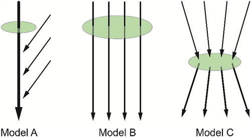
The representation in Figure 1, and the case studies outlined in this Special Issue, suggest that there is no single art-geoscience collaborative model: no one blueprint, and no ‘right’ or ‘wrong’ way to approach art-geoscience collaborations. What appeals to one person or team may well not appeal to or work for another, but rather there is a range of possibilities – a menu of options – when trying to find approaches or strategies that meet the central challenge of communicating geoscientific meaning while maintaining artistic integrity (CitationTooth et al., 2016). In other words, different collaborative ‘models’ are possible, each supporting different working arrangements and practices that may arise serendipitously and defy simple categorisation. At the time of writing (February 2019), the draft ‘Collaboration Blueprint’ available on the Broto website (Broto: Art, Science & Collaboration, Citationn.d.-d) acknowledges the ‘many existing models for collaboration’ but ‘seeks to provide additional context in collaboration space’ by building on already existing art-science work and expertise and by re-examining some of the important conversations about collaboration. So while the outcomes of the developing Broto project are yet to become fully clear, in art-geoscience, and perhaps art-science more broadly, attempts to tightly define the meaning of collaboration may be chimerical, while establishing rules of engagement and formalised guidelines risk becoming restrictive and thus stifling for creativity. But examining what works and what does not work in collaboration certainly is a laudable objective, particularly so that examples of best practice can be shared and the menu of options enlarged to facilitate future art-(geo)science collaborations (cf. CitationRuddock, 2018; CitationWeinberg, 2011). The collection of papers in this Special Issue makes a small contribution to this broader examination.
5. Final remarks
As ever, a Special Issue does not happen without the contributions of many reviewers. All the papers included in this Special Issue were subject to full peer review by at least two independent reviewers drawn from across the arts and geosciences, including individuals who work at the interface of the two spheres: Catherine Baker, Simon Cook, Rahul Devrani, Uwe Dornbusch, Jenny Dunseath, Kate Fahey, Ken Gregory, Hywel Griffiths, Harriet Hawkins, John Krygier, John Lewin, Robert Luzar, Danny McNally, Julian Ruddock, Varyl Thorndycraft, Alexander Tillmann, Corné van Elzakker, and Brian Whalley. All reviewers made constructive suggestions for improvements and/or developments of the initial submissions, and have thereby helped to shape the final products. We extend our thanks to all these reviewers.
Disclosure statement
No potential conflict of interest was reported by the authors.
References
- Ackroyd & Harvey. (n.d.). Works. Retrieved from http://www.ackroydandharvey.com/category/works/
- Allen, P., Hinshelwood, E., Smith, F., Thomas, R., & Woods, S. (2014). Culture shift: How artists are responding to sustainability in Wales. Report commissioned by Emergence. Retrieved from http://www.arts.wales/c_enterprise-and-regeneration/culture-shift
- Art Gallery of Ontario. (2018). Anthropocene: Exhibition overview. Retrieved from https://ago.ca/exhibitions/anthropocene
- Ballengée, B. (n.d.). Brandon Ballengée: Artist//Biologist//Environmental Activist. Retrieved from https://brandonballengee.com/
- British Society for Geomorphology. (n.d.). Visualising geomorphology. Retrieved from https://geomorphology.org.uk/working-groups/visualising-geomorphology
- Broto: Art, Science & Collaboration. (n.d.-a). About Broto. Retrieved from https://broto.eco/about /
- Broto: Art, Science & Collaboration. (n.d.-b). The Broto blog. Retrieved from https://broto.eco/blog /
- Broto: Art, Science & Collaboration. (n.d.-c). Conference satisfaction survey results. Retrieved from https://broto.eco/2018/05/23/conference-satisfaction-survey-results /
- Broto: Art, Science & Collaboration. (n.d.-d). Collaboration Blueprint. Retrieved from https://broto.eco/collaboration-blueprint /
- Cape Farewell. (n.d.). What does culture have to do with climate change? Everything. Retrieved from https://capefarewell.com/
- Center for Research on Environmental Decisions (CRED). (2009). The psychology of climate change communication: A guide for scientists, journalists, educators, political aides, and the interested public. New York, NY.
- Coe, D. E. (2016). Revealing Washington’s hidden landforms with LiDAR (and other elevation data). Washington State Joint Agency GIS Day. Washington State Department of Natural Resources Presentation Archive. Retrieved from https://www.dnr.wa.gov/programs-and-services/geology/publications-and-data/presentation-archive
- Corner, A., Shaw, C., & Clarke, J. (2018). Principles for effective communication and public engagement on climate change: A handbook for IPCC authors. Oxford: Climate Outreach.
- Davis, H., & Turpin, E. (Eds.). (2015). Art in the Anthropocene: Encounters among aesthetics, politics, environments and epistemologies. London: Open Humanities Press.
- Elkins, J. (2009). Aesthetics and the two cultures: Why art and science should be allowed to go their separate ways. In F. Halsall, J. Jansen, & T. O’Connor (Eds.), Rediscovering aesthetics: Transdisciplinary voices from art history, philosophy, and art practice (pp. 34–50). Redwood City, CA: Stanford University Press.
- Esri. (2017). Award-winning story map spells out flood danger to French schoolchildren. Retrieved from: http://www.esri.com/esri-news/arcwatch/0217/award-winning-story-map-spells-out-flood-danger-to-french-schoolchildren
- European Geosciences Union. (n.d.). Geoscience Communication: an interactive open-access journal of the European Geosciences Union. Retrieved from https://www.geoscience-communication.net/)
- Fisk, H. N. (1944). Geological investigation of the alluvial valley of the lower Mississippi River. Washington, DC: US Army Corps of Engineers.
- Foster, K., & Lorimer, H. (2007). Some reflections on art-geography as collaboration. Cultural Geographies, 14, 425–432. doi: 10.1177/1474474007078210
- Frajer, J., & Šimáček, P. (2019). Localisation of the painter’s canvas: Landscape paintings from the Iron Mountains (Czech Republic). Journal of Maps, this issue.
- Gregory, K. J., Lane, S. N., Lewin, J., Ashworth, P. J., Downs, P. W., Kirkby, M. J., & Viles, H. A. (2014). Communicating geomorphology: Global challenges for the twenty-first century. Earth Surface Processes and Landforms, 39, 476–486. doi: 10.1002/esp.3461
- Griffiths, H. M., Goodwin, G., Keevil, T., Salisbury, E., Tooth, S., & Roberts, D. (2017). Searching for an Anthropo(s)cene in the uplands of mid Wales. GeoHumanities, 3, 567–579. doi: 10.1080/2373566X.2017.1329631
- Harold, J., Lorenzoni, I., Shipley, T. F., & Coventry, K. R. (2016). Cognitive and psychological science insights to improve climate change data visualization. Nature Climate Change, 6, 1080–1089. doi: 10.1038/nclimate3162
- Hart, N. (n.d). Ice Report. Naomi Hart//Leverhulme artist in residence. Retrieved from http://icereport.group.shef.ac.uk /
- Hawkins, H. (2013). Geography and art. An expanding field: Site, the body and practice. Progress in Human Geography, 37, 52–71. doi: 10.1177/0309132512442865
- Hutton, C. (1778). An account of the calculations made from the survey and measures taken at Schehallien, in order to ascertain the mean density of the Earth. Philosophical Transactions of the Royal Society of London, 68, 689–788. doi: 10.1098/rstl.1778.0034
- Kirk-Smith, A. (n.d.). Anna Kirk-Smith MA (RCA): On the Endless Here. Retrieved from https://www.annakirksmith.com/ontheendlesshere
- Macklin, J. E., & Macklin, M. G. (2019). Art-geoscience encounters and entanglements in the watery realm. Journal of Maps, this issue.
- Matless, D. (2018). The Anthroposcenic: Landscape in the Anthroposcene. British Art Studies, 10, 28 pp.
- Matthews, J. A., & Herbert, D. T. (2008). Geography: A very short introduction. Oxford: Oxford University Press.
- Mossa, J., Chen, Y. H., & Wu, C.-Y. (2019). Geovisualization geoscience of large river floodplains. Journal of Maps, this issue.
- Mould, S. A. (2019). Seeing double in art and geoscience: 3D aerial portraits of ‘lost’ Anthropocene landscapes. Journal of Maps, this issue.
- Nelson, G. D., & Rae, A. (2016). An economic geography of the United States: From commutes to megaregions. PLOS ONE, 11, e0166083. doi: 10.1371/journal.pone.0166083
- Nicholson, P., Dixon, D., Pullanikkatil, D., Moyo, B., Long, H., & Barrett, B. (2019). ‘Malawi Stories’: Mapping an art-science collaborative process. Journal of Maps, this issue.
- Perry, M. (2017). Land/Sea. Cardiff: Ffotogallery.
- Rann, K., & Johnson, R. S. (2019). Chasing the Line: Hutton’s contribution to the invention of contours. Journal of Maps, this issue.
- Real World Visuals. (n.d.). Real world visuals: Bringing data to life. Retrieved from http://www.realworldvisuals.com/
- Risner, I. J., Naylor, L. A., & Marshall, J. (2019). Interdisciplinary palimpsest: Visual representations of coastal change combining digital craft and geomorphology. Journal of Maps, this issue.
- Ruddock, J. (2018). Navigating the uncertainties of art and science collaboration: A series of projects focussed on climate change (Unpublished PhD thesis). Aberystwyth University, Aberystwyth.
- Ruddock, J. (n.d.). 2A Earth Core: The Hominin Project. Retrieved from https://cargocollective.com/artscienceclimatechange/2A-Earth-Core-The-Hominin-Project
- Schaaf, R., Worrall-Hood, J., & Jones, O. (2017). Geography and art: Encountering place across disciplines. Cultural Geographies, 24, 319–327. doi: 10.1177/1474474016673068
- Shugar, D. H., Colorado, K. A., Clague, J. J., Willis, M. J., & Best, J. L. (2019). ‘Boundary’: Mapping and visualizing climatically changed landscapes at Kaskawulsch Glacier and Kluane Lake, Yukon. Journal of Maps, this issue.
- Smith, M. J., Parrott, F., Monkman, A., O’Connor, J., & Rousham, L. (2019). ‘Reading landscape’: Interdisciplinary approaches to understanding place. Journal of Maps, this issue.
- Snow, C. P. (1959). The two cultures and the scientific revolution. Cambridge, MA: Cambridge University Press.
- Tooth, S. (2009). Invisible geomorphology? Earth Surface Processes and Landforms, 34, 752–754. doi: 10.1002/esp.1724
- Tooth, S. (2016). Art and science collaborations in an age of change. Retrieved from https://stephentooth.wordpress.com/2016/01/23/art-and-science-collaborations-in-an-age-of-change/
- Tooth, S., & Viles, H. A. (2014). 10 reasons why geomorphology is important. Promotional brochure produced on behalf of the British Society for Geomorphology. Retrieved from http://www.geomorphology.org.uk/what-geomorphology
- Tooth, S., Viles, H. A., Dickinson, A., Dixon, S. J., Falcini, A., Griffiths, H. M., … Whalley, B. (2016). Visualizing geomorphology: Improving communication of data and concepts through engagement with the arts. Earth Surface Processes and Landforms, 41, 1793–1796. doi: 10.1002/esp.3990
- Viles, H. (2007). Heritage conservation today: consensus or collision? Report of the meeting held on 18th September 2007, Worcester College, Oxford by the ‘Consensus or Collision?’ Research Cluster.
- Visualising Geomorphology. (n.d.). Visualising geomorphology: Connecting geomorphology, geoscience and art. Retrieved from https://visualgeomorph.wordpress.com/about /
- Weinberg, D. H. (2011). From the Big Bang to Island Universe: Anatomy of a collaboration. Narrative, 19, 258–272. doi: 10.1353/nar.2011.0008
- Wolpert, L. (2002, March 10). Which side are you on? The Observer. Retrieved from https://www.theguardian.com/education/2002/mar/10/arts.highereducation
- Woodward, J. (2015). Is geomorphology sleepwalking into oblivion? Earth Surface Processes and Landforms, 40, 706–709. doi: 10.1002/esp.3692