
 ?Mathematical formulae have been encoded as MathML and are displayed in this HTML version using MathJax in order to improve their display. Uncheck the box to turn MathJax off. This feature requires Javascript. Click on a formula to zoom.
ABSTRACT
Rock glaciers in the southeastern Alps of Slovenia and Italy have been mapped in detail using high resolution digital elevation model and orthophotos, supported by field-based observations. A total of 52 rock glaciers with an area of 3.40 km2 have been delineated on a rock glacier map, divided in 18 sections at a scale of 1:15,000. Several geometrical parameters of rock glaciers have been calculated and their activity degree has been inferred. 90% of rock glaciers have been classified as relict, while the rest are assumed to be of uncertain activity and might still contain some ice. The volumetric ice content and water volume equivalent of the studied rock glaciers for the period of their activity has been calculated to 0.055 ± 0.011 km3 and 0.049 ± 0.010 km3, respectively, which is very close to the ice volume of glaciers reconstructed for this area during the little ice age to 0.069 km3.
1. Introduction
Masses of coarse and angular debris formed as a result of downslope creep of perennially frozen ice-rich debris with peculiar transversal furrows and ridges on the upper surface, which characterize the periglacial mountain domain of several alpine areas of the world, are commonly named rock glaciers (CitationBarsch, 1996; CitationHaeberli, 1985; CitationHaeberli et al., 2006). Together with glaciers they globally represent the largest cryospheric landforms of the mountain domain and widespread components of cold climate environment. They retain the majority of the available fresh water in its solid phase (e.g. CitationChevallier, Pouyaud, Suarez, & Condom, 2011; CitationNicholson et al., 2009; CitationRangecroft, Harrison, & Anderson, 2015). If glaciers are considered excellent climate indicators and their evolution recognized as one of the best indicators of climate change (e.g. CitationHaeberli, Hoelzle, Paul, & Zemp, 2007), rock glaciers are generally more resilient to changes in the climate due to their debris cover (CitationJones, Harrison, Anderson, & Betts, 2018). One of their peculiar characteristics is to retain much of their morphology long after they have ceased moving and permafrost has thawed, displaying smoothed surface topography and gentler front slopes (CitationHughes, Gibbard, & Woodward, 2003).
Ice glacier content and volume are generally easy to estimate (e.g. CitationBolch, Menounos, & Wheate, 2010; CitationBradley, Vuille, Diaz, & Vergara, 2006; CitationChevallier et al., 2011) and it has been done in several occasions in the southeastern Alps (e.g. CitationColucci et al., 2015; CitationColucci et al., 2019; CitationDel Gobbo, Colucci, Forte, Triglav, & Zorn, 2016; CitationForte, Dossi, Fontana, & Colucci, 2014), but this is not the case of rock glaciers due to their variable distribution of ice and challenging determination of the genesis (e.g. CitationRangecroft et al., 2015). Estimates for volumetric ice content within rock glaciers usually range between 40% and 60% according to CitationBarsch (1996), CitationHaeberli et al. (1998) and CitationHausmann, Krainer, Brückl, and Mostler (2007), although estimates of up to 70% have also been detected (e.g. CitationArenson, 2002; CitationBarsch, Fierz, & Haeberli, 1979). Still considerable uncertainties remain regarding the ice content and subsequent water equivalent of the so-called inactive rock glacier (sensu CitationBarsch, 1996), namely those rock glaciers which do contain ice, but are no longer mobile either due to melting of most of the upper ice layers within the terminus slope (climatically inactive), or because of topographic obstacles (dynamically inactive).
In several mountainous regions of the world and particularly in the European Alps the distribution of rock glaciers has been investigated in detail (e.g. CitationColucci, Boccali, Žebre, & Guglielmin, 2016b; CitationGuglielmin & Smiraglia, 1997; CitationKellerer-Pirklbauer, Lieb, & Kleinferchner, 2012; CitationRangecroft et al., 2014; CitationSeppi, Carton, & Baroni, 2010), but very scarce information regarding the volume estimation of ice and water equivalent at present exists, particularly if related to the distribution of relict rock glaciers, i.e. the rock glaciers that were active in the past. On the other hand, relict rock glaciers are recognized to have high storage capacity able to influence the water resources management in alpine catchments and mitigate the risk of natural hazards related to heavy precipitation events (CitationWinkler et al., 2016). Nevertheless, the lack of such studies performed on carbonate rocks with high permeability such as limestones means that any further considerations on rock glaciers storage capacity would result to be over speculative in this study area.
In the southeastern Alps, the exact timing and extent of Lateglacial glaciations are still largely unknown (CitationKozamernik, Colucci, Stepišnik, Forte, & Žebre, 2018). On the other hand the onset and decay of rock glaciers have been related to the Younger Dryas (YD) cold phase event and the subsequent climate amelioration of the early Holocene (CitationColucci et al., 2016b). However, this description lacks the real size in terms of ice volume and water content which are instead known for glaciers at the LIA peak (CitationColucci & Žebre, 2016) but still unknown for the Lateglacial phases.
Therefore, the main purposes of this paper are: (1) to estimate the volume and calculate the available water content of each relict rock glacier in the southeastern Alps of Italy and Slovenia for the period in which they were still active and (2) to present a rock glacier map of the southeastern Alps, including the main geomorphological features (e.g. perimeter, rock glacier front) on the basis of a 1 m cell digital terrain model (DTM).
The recent production of extremely detailed topography of Slovenia and Friuli Venezia Giulia (the northeastern-most Administrative Region of Italy) areas using light detection and ranging (LiDAR) data, was a further motivation to improve the accuracy of this inventory.
Moreover, the same areas of both countries have been recently surveyed by several authors and with different purposes, in order to map and rise knowledge about the coastal areas (CitationBiolchi, Furlani, Covelli, Busetti, & Cucchi, 2016), the Classical Karst region (CitationJurkovšek et al., 2016), the hydrogeological functioning of the alluvial plain (CitationTreu et al., 2017) as well as the sinkhole occurrence and analysis (CitationCalligaris, Devoto, & Zini, 2017). Glacial features and morphologies were already mapped by CitationColucci and Žebre (2016) and CitationŽebre and Stepišnik (2016), therefore this work is part of an extensive effort aiming for a better understanding of environments and landscapes of this transboundary European area.
2. Study Area
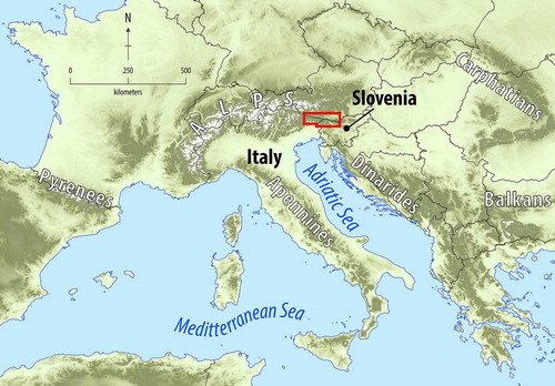
The study area extends from 46°15′ N to 46°38′ N and from 12°25′ E to 14°37′ E, including the northern part of Friuli Venezia Giulia Region in Italy and the northwestern part of Slovenia. The study area comprehends about 6000 km2, covering from west to east the Carnic Prealps and Alps, the Julian Alps and the Karavanke Mountains. Mt. Coglians–Hohe Warte (2,780 m a.s.l.) in the Carnic Alps and Mt. Triglav (2,864 m a.s.l.) in the Julian Alps are the two highest summits in the study area, respectively ().
Figure 1. Study area, highlighted with the red square, within the northern Mediterranean – Alpine region.
Sedimentary carbonate rocks prevail in the area, while igneous and metamorphic rocks are present to a limited extent in the Western Carnic Alps (CitationCarulli, 2006) and Karavanke Mountains (CitationKomac, 2005).
The 1981–2010 mean annual precipitation (MAP) is at its highest in the Julian Alps with totals higher than 3300 mm (CitationColucci & Guglielmin, 2015), but in the inner alpine Carnic sector decreases to 1600–1800 mm because of the precipitation shadow effect of the Prealps. Towards east the MAP decreases down to <1000 mm. The mean annual air temperature (MAAT) is strongly influenced by the altitudinal lapse rate but shows a decreasing trend from the prealpine reliefs to the inner alpine sectors and towards the east in Slovenia. The 1981–2010 MAAT point out to extremes of ca. −2.6°C on the highest peaks with the −2°C isotherm, which defines environments where frost action is dominant (CitationFrench, 2007), estimated at 2,665 ± 90 m a.s.l. The 0°C-isotherm is estimated at an altitude of 2,370 ± 90 m a.s.l.
The present cryosphere in the study area consists of 23 ice bodies, covering a total area of 0.358 km2 (CitationColucci, 2016) and more than a thousand caves located above 1,000 m a.s.l., which host snow, firn, and ice deposits (CitationColucci, Fontana, Forte, Potleca, & Guglielmin, 2016a). On the other hand, no active rock glaciers are present in the study area nowadays although few of them present uncertain activity due to their geomorphological characteristics. According to CitationColucci et al. (2016b) relict rock glaciers, distributed between 1,708 and 1,846 m a.s.l., cover an area of 3.45 km2 and were likely active during the Lateglacial developing during different periods of the Holocene. The Little Ice Age (LIA) maximum extent of glaciers was estimated to 2.35 km2 (CitationColucci, 2016) with a volume equal to 0.068 km3 (CitationColucci & Žebre, 2016). At present (2012) the volume is reduced by 96% and equals 0.0027 km3.
3. Materials and methods
The inventory of rock glaciers has been made by inspecting medium (0.5 m pixel; 1998, 2003, 2011 and 2014) and high resolution (0.15 m pixel; 2006–2009) aerial orthorectified photographs (orthophoto) (provided by Friuli Venezia Giulia Region and the Surveying and Mapping Authority of the Republic of Slovenia), as well as high resolution (1.0 m cell size) DTM and shaded relief interpolated from airborne laser scanning (LiDAR) data acquired between September 2006 and September 2009 for Friuli Venezia Giulia Region (CitationRAFVG, 2006–Citation2009) and between February 2011 and April 2015 for Slovenia (CitationMinistry of the Environment and Spatial Planning, Slovenian Environment Agency, 2011–2015). The analysis of the aforementioned spatial data served as a basis for the field-based geomorphological mapping, accurate delineation of landforms and extraction of their morphometric characteristics ().
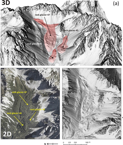
Figure 2. (a) The extent of Brica (n. 47 in the Main Map), del Cason (n. 45) and dell’Inferno (n. 46) rock glaciers as seen from the shaded relief projected on the 1 m cell size DTM in 3D view, (b) vegetation cover as seen from the ortophoto projected on the shaded relief in 2D view, and (c) their typical morphology resembling the lava flow shown on the shaded relief in 2D view.
3.1. Topographic base
The topographic base of the Main Map at a scale of 1:150,000 is composed of a 10 m resolution DTM (CitationRAFVG, 2006–Citation2009) and a 12.5 m resolution DTM (Surveying and Mapping Authority of the Republic of Slovenia, Citation2001–2005), portrayed with a background shaded relief map (see Main Map ). The hydrography, comprising water courses of 1st, 2nd, 3rd and 4th order, the most important mountain peaks, the extent of glaciers and ice patches at the Little Ice Age peak and in 2012 (CitationColucci & Žebre, 2016) and the main towns are also shown. The coordinate system of the Main Map is WGS_1984_UTM_Zone_33N.
The topographic base of the 18 frames (from a to t; see Main Map ), at a scale of 1:15,000, is a shaded relief map in grayscale covered by a colored DTM with a 1 m resolution. The coordinate system of the frames is the same of the Main Map (WGS_1984_UTM_Zone_33N).
The base layer of the geographical settings is a 30 m resolution ASTER Global Digital Elevation Model (ASTER GDEM) in a World Geodetic System 1984 (D_WGS_84) (http://gdem.ersdac.jspacesystems.or.jp/) with 20 m vertical and 30 m horizontal data accuracy (CitationASTER GDEM Readme File).
3.2. Data collection
Fieldwork, analysis of high resolution DTMs, orthophotos, Google Earth® and Bing® images were used in collecting the data for the map production. Fieldwork was carried out between 2013 and 2017 and included geomorphological mapping of periglacial features as well as verification of all landforms as recognized from remote sensing analysis, both for the Italian and Slovenian side of the southeastern Alps.
3.3. Geomorphological features
Periglacial landforms (rock glacier front, perimeter) were drawn on the basis of geomorphological mapping conducted in the field, and the analysis of LiDAR data, aerial photographs, and orthophotos.
By carefully looking at the surface morphology, consistent effort was used in the determination of the rooting zone where the rock glacier meets the input accumulation zone, and its upper limit. Rock glaciers were further classified according to the geometry into lobate rock glaciers that present a length/width ratio <1 and tongue-shaped rock glaciers, having typical length/width ratio >1 (CitationWahrhaftig & Cox, 1959).
3.4. Topographic names
The topographic names for the Italian side were derived from topographic maps Tabacco 1:25,000 (1993–2003) (sheets: 01, Sappada-S. Stefano-Forni Avoltri; 02, Forni di Sopra-Ampezzo-Sauris-Alta Val Tagliamento; 09, Alpi Carniche-Carnia centrale; 018, Alpi Carniche orientali-Canal del Ferro; 019, Alpi Giulie occidentali-Tarvisiano; 027, Canin-Val Resia-Parco Naturale Prealpi Giulie), by using toponyms generally derived from mountain peaks, huts or paths located in the vicinity of the landforms. The topographic names for the Slovenian side were obtained from the Topographic maps of the Republic of Slovenia in scale 1:25,000 (Citation1993–1999) (sheets: Koren 021; Kepa 022; Log pod Mangartom 039; Rateče 040; Kranjska Gora 041; Vrba 044; Spodnje Jezersko 046; Breginj 064; Soča 066; Ukanc 067;Kamniška Bistrica 073; Luče 074).
3.5. Volumetric ice content and water volume equivalent of rock glaciers
Ice volume of the studied rock glaciers was estimated on the basis of assumed volumetric ice content within intact rock glaciers and rock glaciers volume. Relict rock glaciers present heterogeneous aquifer and their present water storage is difficult to quantify without a detailed internal structure and dye-tracing measurements (CitationWinkler et al., 2016). Our current data does not allow making any conclusion on their present capacity for storing the water. Worldwide field-supported studies, instead, suggest the volumetric ice content within active rock glaciers often range between 40% and 60% (e.g. CitationArenson, 2002; CitationHausmann et al., 2007, Citation2012), although the range can be even larger (e.g. CitationArenson et al., 2010) (). In this paper, the volumetric ice content of 40–60% has been considered as the most probable and thus used in ice volume estimations. Adopting the same percentage array as majority of the studies (e.g. CitationJones et al., 2018) also enables comparison among different research. Volume of rock glaciers was estimated by multiplying rock glacier surface area (A) and thickness (H). The first parameter was extracted from LiDAR data, using previously defined rock glacier polygon. The second parameter was estimated using an empirical rule established by CitationBrenning (2005) based on field observations of rock glacier polygons. According to this power-law relationship (Equation (1)) the mean rock glacier thickness (H; in meters) is calculated as a function of surface area (A; in square kilometers) and two scaling parameters (c and β)(1)
(1) where c is 50 and β is 0.2.
Table 1. Field-based observations of ice content (%) by rock glacier volume reported in the literature.
Ice volume estimates were subsequently used for calculating the water volume equivalent (w.v.e.) (CitationBrenning, 2005; CitationJones et al., 2018) for the time when these rock glaciers were still active by assuming an ice density conversion factor of 900 kg m−3 (CitationPaterson, 1994).
4. Results
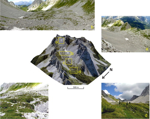
52 rock glaciers have been mapped and analyzed in the southeastern Alps mainly concentrated in the Carnic Alps sector (27 rock glaciers) and in the Carnic Prealps (14 rock glaciers). The total area of rock glaciers in the southeastern Alps has been calculated to 3.40 km2, which is 0.006% less than the previous estimations by CitationColucci et al. (2016b) (i.e. 1 rock glacier was excluded from results of this previous paper after field observations). Following the geomorphological approach described in CitationColucci et al. (2016b) and given the lack of geophysical investigations to determine the presence or lack of ice in the landforms, 47 rock glaciers have been classified as relict, and 6 of uncertain activity. The Tiarfin rock glacier () being the longest (ca. 1.1 km) among the studied landforms has been classified as complex in the group of the 5 of uncertain activity due to variable geomorphological characteristics along the longitudinal section, from its rooting zone to the terminus. It has the highest mean elevation (2,148 m a.s.l.) developing from 2,275 m a.s.l. to 2,080 m a.s.l. The upper part is characterized by a series of well-developed and sharp protalus ramparts located at the highest elevation of the rock glacier complex ((a)). Here both the Alpine permafrost index map (APIM) (CitationBoeckli, Brenning, Gruber, & Noetzli, 2012) and a Bottom Temperature of Snow cover (BTS) measurements campaign performed in March 2013 point to a likely presence of permafrost in the scree slope. The central part of the rock glacier is characterized by several ridges and furrows clearly recognizable also from the field ((b)). Small dolines likely due to thermokarst activity or suffusion is a characteristic of the sector between roughly 2,120 and 2,080 m a.s.l. ((c)) with increasing vegetation cover moving towards the frontal part of the rock glacier where small Larix and Pinus mugo grow over continuous meadows ((d)).
Figure 3. 3D image of Tiarfin rock glacier (n. 23 in the Main Map) realized by projecting the 2008 ortophoto on the 1 m cell size DTM. Details of different parts of this landform are highlighted in the Squares: (a) protalus ramparts located at the highest elevation of the rock glacier complex; (b) the central part where several ridges and furrows are clearly visible also from the field; (c) small dolines over the rock glacier surface likely due to thermokarst activity or suffosion; (d) the vegetated frontal part of the rock glacier with small Larix and Pinus mugo.
The regional mean altitude of all the rock glacier’s fronts is calculated to 1,720 m a.s.l. (st. dev. 230 m). Rock glaciers are generally characterized by discontinuous to continuous vegetation cover (), mainly P. mugo, Larix and Picea with only nine of them occurring above the timber line as in the case of Tiarfin rock glacier ().
The total volume of the studied rock glaciers has been estimated to 0.109 km3 (). By applying the assumed ice content of 50 ± 10%, the total volumetric ice content of rock glaciers is 0.055 ± 0.011 km3, while their w.v.e. is 0.049 ± 0.010 km3 (). As a reference, this is roughly 50% less than the estimated water volume of lake Bohinj (Slovenia; See the Main Map) the largest permanent lake in the study area (0.0997 km3; CitationHlad and Skoberne (2001)). The volume of the artificial lake of Sauris (see the Main Map) in the Carnic Alps is calculated to 0.07 km3. Since the majority of rock glaciers were defined as relict, their volume estimates and therefore also the ice content and w.v.e. are given for their active state in the past. It has been inferred on the basis of the paleoclimate analysis that these rock glaciers are likely related to the Younger Dryas cold phase; however, older age for some of them cannot be excluded. Only 6 rock glaciers among the identified 52 are defined as of uncertain activity degree of which 1 as complex. These 6 rock glaciers may still contain some ice also in the recent climate, but most probably significantly less than during the Younger Dryas. It is worth noting that there are no direct field measurements of rock glacier thickness and ice content in our study area, therefore these are unknown variables and their uncertainty is difficult to quantify. The power-law relationship (EquationEquation 1(1)
(1) ) for calculating the mean rock glacier thickness used in our study was developed for rock glaciers in Central Chile (CitationBrenning, 2005), which means it cannot necessarily account best for our regional inventory. Apart from that, also the genesis (permafrost origin versus glacigenic origin) of the studied rock glaciers, strongly influencing the ice content estimations, is uncertain as well. All in all, our results present the first-order approximation and more field research is needed to better address and understand these uncertainties.
Table 2. Some statistics of the studied rock glaciers, including estimations of their paleo-ice volume and paleo-water volume equivalent.
The estimated total volumetric ice content of rock glaciers in the southeastern Alps during Younger Dryas is similar to the ice volume of glaciers during Little Ice Age in the same area. The latter has been calculated to 0.068 km3 (CitationColucci & Žebre, 2016).
5. Conclusions
A revised mapping of rock glaciers in several sectors of the southeastern European Alps (Carnic Alps and Prealps, Julian Alps and Prealps, southern Karavanke Mountains) has been produced for the first time after verification of all the landforms on the field. Detailed geomorphological mapping performed through LiDAR surveys allowed a revised quantification of area, thickness and volume of rock glaciers in order to estimate their paleo-ice volume for the time when such landforms were still active, by using a power-law equation. Moreover, a detailed morphology of every rock glacier of the Italian and Slovenian southeastern Alps is now clearly visible in the Main Map. The estimated total volumetric ice content of rock glaciers, which are thought to have been formed during the Younger Dryas cold event, is close to the ice volume of glaciers calculated in this area at the peak of the Little Ice Age.
Software
The maps were produced by means of Esri ArcGIS v. 10.4, while Adobe Illustrator CS6 and Adobe InDesign CS6 were used for graphic operations and layout building, respectively.
Author contribution
RRC conceived this study. CB realized the map, elaborated the RAW LiDAR data and undertook the GIS/statistical analysis. RRC, CB and MŽ made the field observations. RRC and MŽ wrote the manuscript and edited tables and figures, with the help of CB.
Boccali-etal-Map_RGB_rid.pdf
Download PDF (48.8 MB)Acknowledgments
We acknowledge Chris Orton, Thomas Wagner and Philippe Schoeneich as well as the Editor Jan-Christoph Otto for their useful suggestions in reviewing a first version of the manuscript. We also deeply thank Sara Biolchi for her help and suggestions in revising the Main Map.
Disclosure statement
No potential conflict of interest was reported by the authors.
ORCID
C. Boccali http://orcid.org/0000-0003-4564-2253
M. Žebre http://orcid.org/0000-0001-6772-2866
R. R. Colucci http://orcid.org/0000-0001-8344-5723
Related Research Data
References
- Arenson, L. U. (2002). Unstable alpine permafrost: a potentially important natural hazard – variations of geotechnical behaviour with time and temperature (Doctoral Thesis) Institute for Geotechnical Engineering, Swiss Federal Institute of Technology ETH Zurich.
- Arenson, L. U. , Pastore, S. , Trombotto Liaudat, D. , Bolling, S. , Quiroz, M. A. , & Ochoa, X. L. (2010). Characteristics of two Rock Glaciers in the Dry Argentinean Andes Based on Initial Surface Investigations. In Proceedings of the 63rd Canadian Geotechnical Conference & 6th Canadian Permafrost Conference, Calgary, Canada, 12-16 September 2009 (pp. 1501–1508).
- ASTER GDEM Readme File . Retreived from http://www.gisat.cz/images/upload/6fbe0_aster-gdem-readme-ev1-dot-0.pdf
- Barsch, D. (1977). Ein Permafrostprofil aus Graubünden, Schweizer Alpen. Zeitschrift Für Geomorphologie , 21, 79–86.
- Barsch, D. (1996). Rockglaciers : indicators for the present and Former Geoecology in high mountain environments . Berlin Heidelberg : Springer-Verlag. doi: 10.1007/978-3-642-800993-1
- Barsch, D. , Fierz, H. , & Haeberli, W. (1979). Shallow Core Drilling and Bore-Hole measurements in the permafrost of an active rock glacier near the Grubengletscher, Wallis, Swiss Alps. Arctic and Alpine Research , 11 , 215–228. doi: 10.2307/1550646
- Biolchi, S. , Furlani, S. , Covelli, S. , Busetti, M. , & Cucchi, F. (2016). Morphoneotectonics and lithology of the eastern sector of the Gulf of Trieste (NE Italy). Journal of Maps , 12 , 936–946. doi: 10.1080/17445647.2015.1099572
- Boeckli, L. , Brenning, A. , Gruber, S. , & Noetzli, J. (2012). Permafrost distribution in the European Alps: Calculation and evaluation of an index map and summary statistics. Cryosphere , 6 , 807–820. doi: 10.5194/tc-6-807-2012
- Bolch, T. , Menounos, B. , & Wheate, R. (2010). Landsat-based inventory of glaciers in western Canada, 1985-2005. Remote Sensing of Environment , 114 , 127–137. doi: 10.1016/j.rse.2009.08.015
- Bradley, R. S. , Vuille, M. , Diaz, H. F. , & Vergara, W. (2006). Threats to water supplies in the tropical Andes. Science , 312 , 1755–1756. doi: 10.1126/science.1128087
- Brenning, A. (2005). Climatic and geomorphological controls of rock glaciers in the Andes of Central Chile. Humboldt-Universität zu Berlin, Mathematisch-Naturwissenschaftliche Fakultät II. doi: 10.18452/15332
- Calligaris, C. , Devoto, S. , & Zini, L. (2017). Evaporite sinkholes of the Friuli Venezia Giulia region (NE Italy). Journal of Maps , 13 , 406–414. doi: 10.1080/17445647.2017.1316321
- Carulli, G. B. (2006). Note illustrative alla carta geologica del Friuli Venezia Giulia. . Firenze : S.E.L.C.A.
- Chevallier, P. , Pouyaud, B. , Suarez, W. , & Condom, T. (2011). Climate change threats to environment in the tropical Andes: Glaciers and water resources. Regional Environmental Change , 11 , 179–187. doi: 10.1007/s10113-010-0177-6
- Colucci, R. R. (2016). Geomorphic influence on small glacier response to post-Little Ice Age climate warming: Julian Alps, Europe. Earth Surface Processes and Landforms , 41 , 1227–1240. doi: 10.1002/esp.3908
- Colucci, R. R. , Fontana, D. , Forte, E. , Potleca, M. , & Guglielmin, M. (2016a). Response of ice caves to weather extremes in the southeastern Alps, Europe. Geomorphology , 261 , 1–11. doi: 10.1016/j.geomorph.2016.02.017
- Colucci, R. R. , Boccali, C. , Žebre, M. , & Guglielmin, M. (2016b). Rock glaciers, protalus ramparts and pronival ramparts in the south-eastern Alps. Geomorphology , 269 , 112–121. doi: 10.1016/j.geomorph.2016.06.039
- Colucci, R. R. , Forte, E. , Boccali, C. , Dossi, M. , Lanza, L. , Pipan, M. , & Guglielmin, M. (2015). Evaluation of internal structure, volume and Mass of Glacial bodies by Integrated LiDAR and Ground Penetrating Radar surveys: The case study of Canin Eastern Glacieret (Julian Alps, Italy). Surveys in Geophysics , 36 , 231–252. doi: 10.1007/s10712-014-9311-1
- Colucci, R. R. , Forte, E. , Žebre, M. , Maset, E. , Zanettini, C. , & Guglielmin, M. (2019). Is that a relict rock glacier? Geomorphology , 330 , 177–189. doi: 10.1016/j.geomorph.2019.02.002
- Colucci, R. R. , & Guglielmin, M. (2015). Precipitation–temperature changes and evolution of a small glacier in the southeastern European Alps during the last 90 years. International Journal of Climatology , 35 , 2783–2797. doi: 10.1002/joc.4172
- Colucci, R. R. , & Žebre, M. (2016). Late Holocene evolution of glaciers in the southeastern Alps. Journal of Maps , 12 , 289–299. doi: 10.1080/17445647.2016.1203216
- Croce, F. A. , & Milana, J. P. (2002). Internal structure and behaviour of a rock glacier in the arid Andes of Argentina. Permafrost and Periglacial Processes , 13 (4), 289–299. doi: 10.1002/ppp.431
- Del Gobbo, C. , Colucci, R. R. , Forte, E. , Triglav, M. , & Zorn, M. (2016). The Triglav glacier (Eastern Alps, Slovenia): volume estimation, internal characterization and 2000-2013 temporal evolution by means of Ground Penetrating Radar measurements. Pure and Applied Geophysics , 173 , 2753–2766. doi: 10.1007/s00024-016-1348-2
- Forte, E. , Dossi, M. , Fontana, M. C. , & Colucci, R. R. (2014). 4-D quantitative GPR analyses to study the summer mass balance of a glacier: A case history. Proceedings of the 15th International Conference on Ground Penetrating Radar . doi: 10.1109/ICGPR.2014.6970444
- French, H. M. (2007). The periglacial environment (3rd ed.). Chichester : John Wiley & Sons, Ltd.
- Guglielmin, M. , & Smiraglia, C. (1997). Catasto Dei Rock Glaciers Delle Alpi Italiane. In: Archivio Comitato Glaciologico Italiano 3. pp. 1–103.
- Haeberli, W. (1985). Creep of mountain permafrost: Internal structure and flow of alpine rock glaciers. Mitteilungen der Versuchsanstalt fur Wasserbau, Hydrologie und Glaziologie an der ETH Zurich , 77 , 5–142.
- Haeberli, W. , Hallet, B. , Arenson, L. , Elconin, R. , Humlum, O. , Kääb, A. , … Mühll, D. V. (2006). Permafrost creep and rock glacier dynamics. Permafrost and Periglacial Processes , 17 , 189–214. doi: 10.1002/ppp.561
- Haeberli, W. , Hoelzle, M. , Kääb, A. , Keller, F. , Vonder Müll, D. , & Wagner, S. (1998). Ten years after drilling through the permafrost of the active rock glacier Murtèl, Eastern Swiss Alps: Answered questions and new perspectives. PERMAFROST - Seventh International Conference , 403–410.
- Haeberli, W. , Hoelzle, M. , Paul, F. , & Zemp, M. (2007). Integrated monitoring of mountain glaciers as key indicators of global climate change: The European Alps. Annals of Glaciology , 46 , 150–160. doi: 10.3189/172756407782871512
- Hausmann, H. , Krainer, K. , Bruckl, E. , & Ullrich, C. (2012). Internal structure, ice content and dynamics of Olgrube and Kaiserberg rock glaciers (Otztal Alps, Austria) determined from geophysical surveys. Austrian Journal of Earth Sciences , 105 , 12–31.
- Hausmann, H. , Krainer, K. , Brückl, E. , & Mostler, W. (2007). Internal structure and ice content of Reichenkar rock glacier (Stubai Alps, Austria) assessed by geophysical investigations. Permafrost and Periglacial Processes , 18 , 351–367. doi: 10.1002/ppp.601
- Hlad, B. , & Skoberne, P. (2001). Biological and landscape diversity in Slovenia: An overview. Ministry of the Environment and Spatial Planning; Surveying and Mapping Authority of the Republic of Slovenia, Environmental Agency of the Republic of Slovenia, Ljubljana. Retrieved from http://www.mop.gov.si/fileadmin/mop.gov.si/pageuploads/publikacije/en/biological_landscape_diversity_in_slovenia.pdf
- Hughes, P. D. , Gibbard, P. L. , & Woodward, J. C. (2003). Relict rock glaciers as indicators of Mediterranean palaeoclimate during the Last Glacial maximum (Late Würmian) in northwest Greece. Journal of Quaternary Science , 18 , 431–440. doi: 10.1002/jqs.764
- Jones, D. B. , Harrison, S. , Anderson, K. , & Betts, R. A. (2018). Mountain rock glaciers contain globally significant water stores. Scientific Reports , 8 , 2834. doi: 10.1038/s41598-018-21244-w
- Jurkovšek, B. , Biolchi, S. , Furlani, S. , Kolar-Jurkovšek, T. , Zini, L. , Jež, J. , … Cucchi, F. (2016). Geology of the Classical Karst Region (SW Slovenia–NE Italy). Journal of Maps , 12 , 352–362. doi: 10.1080/17445647.2016.1215941
- Kellerer-Pirklbauer, A. , Lieb, G. K. , & Kleinferchner, H. (2012). A new rock glacier inventory of the eastern European Alps. Austrian Journal of Earth Sciences , 105 , 78–93.
- Komac, M. (2005). Statistics of the Geological Map of Slovenia at scale 1: 250.000 = statistika Geološke karte Slovenije 1 250.000. Geologija , 48 , str. 117–126. doi: 10.5474/geologija.2005.011
- Kozamernik, E. , Colucci, R. R. , Stepišnik, U. , Forte, E. , & Žebre, M. (2018). Spatial and climatic characterization of three glacial stages in the upper Krnica valley, SE European Alps. Quaternary International , 470 , 67–81. doi: 10.1016/j.quaint.2017.05.047
- Krainer, K. , Bressan, D. , Dietre, B. , Haas, J. N. , Hajdas, I. , Lang, K. , … Tonidandel, D. (2015). A 10,300-year-old permafrost core from the active rock glacier Lazaun, southern Ötztal Alps (South Tyrol, northern Italy). Quaternary Research (United States ), 83 (2), 324–335. doi: 10.1016/j.yqres.2014.12.005
- Ministry of the Environment and Spatial Planning, Slovenian Environment Agency . (2011-2015). LiDAR data Slovenia. Retrieved from http://gis.arso.gov.si/evode/profile.aspx?id=atlas_voda_Lidar@Arso
- Monnier, S. , & Kinnard, C. (2013). Internal structure and composition of a rock glacier in the Andes (upper Choapa valley, Chile) using borehole information and ground-penetrating radar. Annals of Glaciology , 54 (64), 61–72. doi: 10.3189/2013AoG64A107
- Nicholson, L. , Marin, J. , Lopez, D. , Rabatel, A. , Bown, F. , & Rivera, A. (2009). Glacier inventory of the upper Huasco valley, Norte Chico, Chile: Glacier characteristics, glacier change and comparison with central Chile. Annals of Glaciology , 50 , 111–118. doi: 10.3189/172756410790595787
- Paterson, W. S. B. (1994). The Physics of glaciers . Oxford : Butterworth-Heinemann.
- RAFVG, R.A.F.V.G. (2006). Digital Terrain Model cell size 10 m. Retreived from http://irdat.regione.fvg.it/CTRN/ricerca-cartografia/
- RAFVG, R.A.F.V.G. (2009). LiDAR data. Retreived from http://irdat.regione.fvg.it/CTRN/ricerca-cartografia/
- Rangecroft, S. , Harrison, S. , & Anderson, K. (2015). Rock glaciers as water stores in the Bolivian Andes: An assessment of their hydrological importance. Arctic, Antarctic, and Alpine Research , 47 , 89–98. doi: 10.1657/AAAR0014-029
- Rangecroft, S. , Harrison, S. , Anderson, K. , Magrath, J. , Castel, A. P. , & Pacheco, P. (2014). A first rock glacier inventory for the Bolivian Andes. Permafrost and Periglacial Processes , 25 , 333–343. doi: 10.1002/ppp.1816
- Seppi, R. , Carton, A. , & Baroni, C. (2010). Rock glacier relitti e antica distribuzione del permafrost nel Gruppo Adamello Presanella (Alpi Centrali). Il Quaternario, Italian Journal of Quaternary Sciences , 23 , 137–144.
- Surveying and Mapping Authority of the Republic of Slovenia . (2001). Digital elevation model cell size 12.5 m. Retreived from http://prostor4.gov.si/imps/srv/slv/catalog.search#/metadata/4ac9a90e-7694-42eb-870a-c11ef93783c4
- Topographic maps of the Republic of Slovenia in scale 1:25000 . (1993). Ljubljana: Ministry of the Environment and Spatial Planning; Surveying and Mapping Authority of the Republic of Slovenia.
- Treu, F. , Zini, L. , Zavagno, E. , Biolchi, S. , Boccali, C. , Gregorič, A. , … Cucchi, F. (2017). Intrinsic vulnerability of the Isonzo/Soča high plain aquifer (NE Italy – W Slovenia). Journal of Maps , 13 , 799–810. doi: 10.1080/17445647.2017.1384935
- Wahrhaftig, C. , & Cox, A. (1959). Rock glaciers in Alaska. Geological Society of America Bulletin , 70 , 383–436. doi: 10.1130/0016-7606(1959)70[383:RGITAR]2.0.CO;2
- Winkler, G. , Wagner, T. , Pauritsch, M. , Birk, S. , Kellerer-Pirklbauer, A. , Benischke, R. , … Hergarten, S. (2016). Identification and assessment of groundwater flow and storage components of the relict Schöneben rock glacier, Niedere Tauern range, Eastern Alps (Austria). Hydrogeology Journal , 24 , 937–953. doi: 10.1007/s10040-015-1348-9
- Žebre, M. , & Stepišnik, U. (2016). Glaciokarst geomorphology of the northern Dinaric Alps: Snežnik (Slovenia) and Gorski Kotar (Croatia). Journal of Maps , 12 , 873–881. doi: 10.1080/17445647.2015.1095133