
ABSTRACT
Depending on its chemical and mineralogical composition, the serpentinite represents a peculiar rocky material, which plays a significant role in influencing pedogenetic weathering, vegetation ecology, geo-mechanical and tectonic processes, as well as gravitational slope failure. In serpentinite-bearing environments the response to gravitational stress is more effective than in other rock types. In the Monviso meta-ophiolite Complex (Western Alps), a close relation between landsliding and serpentinite rock occurrences is particularly evident. Our geological map (Main Map), at a scale 1:10,000, illustrates the geology and geomorphological features of the Pui-Orgiera giant (2.98 km2) complex landslide, located on the southern slope of the Monviso Massif. This map clearly documents that the characteristics and kinematics of the landslide are closely associated to the anomalous thickening and widening increase of the Baracun Shear Zone, a remnants of an intra-oceanic detachment fault which separates serpentinite and meta-intrusives from metabasalt and metasediments of the Monviso meta-ophiolite Complex.
1. Introduction
The serpentinite represents a very unique rocky material in terms of pedogenic processes (CitationAlexander & DuShey, 2011; CitationAlexander, Coleman, Keeler-Wolf, & Harrison, 2007; CitationLee, Graham, Laurent, & Amrhein, 2004), plant ecology (CitationD’Amico & Previtali, 2012; CitationKruckeberg, 1984), and tectonic processes (CitationHilairet et al., 2007). Depending on its chemical composition and the crystallographic specificity of serpentine minerals (CitationGuillot, Schwartz, Reynard, Agard, & Prigent, 2015), the serpentinite favours the formation of localized mechanical and rheological weakness horizons, which may act as lubricant surfaces (CitationAmiguet, Van De Moortèle, Cordier, Hilairet, & Reynard, 2014), concentrating short to long-lived tectonic and gravitational deformation. In subaerial serpentinite-bearing environments the response to gravitational stress is more effective than in other rock types as well-documented by both large-scale mass wasting occurrences in various ophiolitic complexes ( CitationCowan & Mansfield, 1970; CitationYamagishi & Ito, 1994; CitationYatabe, Yagi, & Yokota, 1997) and the close relationships between landslides and pervasive deformed serpentinite (CitationBrandolini, Nosengo, Pittaluga, Ramella, & Razzore, 1999; CitationColeman, 1996; CitationCowan & Mansfield, 1970; CitationDickinson, 1966; CitationFioraso, Tararbra, & Negro, 2010; CitationPhipps, 1984; CitationStark, Newman, de la Peña, & Hillebrandt, 2011; CitationYatabe, Bhandary, & Okamura, 2007).
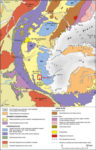
In the Italian Alps, the IFFI project (Inventory of Landslide Phenomena in Italy; http://www.isprambiente.gov.it/en/projects/soil-and-territory/iffi-project) outlines a close relation between landsliding and serpentinite rock occurrences as particularly evident in the Monviso meta-ophiolite Complex (MO hereafter; see CitationBalestro et al., 2014; CitationBalestro, Fioraso, & Lombardo, 2011, Citation2013) (), which represents a remnant of the Jurassic Alpine Tethys stacked in the Western Alps (CitationBalestro, Festa, Dilek, & Tartarotti, 2015; CitationFesta, Balestro, Dilek, & Tartarotti, 2015; CitationLombardo, Rubatto, & Castelli, 2002).
Figure 1. Structural sketch map of the Western Alps (modified from CitationBigi et al., 1990; and CitationPiana et al., 2017). The red inset shows the investigated area represented in the Main Map.
In this paper and related geological map at 1:10,000 scale (Main Map), we illustrate the geology and geomorphological features of the Pui-Orgiera giant complex landslide, located on the left side of the Varaita Valley (southern slope of the Monviso Massif) between the hamlets of Confine and Villar (). It represents one of the most impressive instability phenomena in ophiolite rock units of the Alps, in terms of size, kinematics and morphological evolution. This landslide, in turn, is located in a slope extensively affected by an imposing deep-seated gravitational deformation. In addition to Quaternary deposits and morphological features, particular attention was paid to the mapping of both geological and structural settings of the bedrock, which are crucial to better constrain the collapse mechanisms of the landslide, involving serpentinite bedrock. Our findings provide a better understanding of the landslide evolution, which is useful for both the mitigation of potential future risks for local settlements, and the definition of useful criteria for study of similar serpentinite-related landslides around the world.
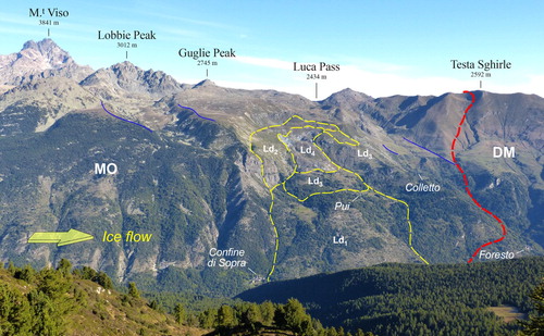
Figure 2. Panoramic view of the left side of the Varaita Valley. Red dashed line: tectonic contact between the Monviso meta-ophiolite Complex (MO) and the Dora-Maira Unit (DM). Yellow dashed lines: boundaries of the Pui-Orgiera landslide and related sectors (Ld1–Ld4). Blue lines: lateral moraine ridges related to the Last Glacial Maximum. Photo taken from Sampeyre Pass (2283 m a.s.l.), view looking N (Long. 7°07′09″, Lat. 44°33′04″).
2. Methods
The Main Map, at a scale of 1:10,000, encompasses an area of 23.74 km2 located on the southern slope of the Monviso Massif, in the central Cottian Alps (). Detailed geological data and geomorphological features were collected by original mapping performed at 1:5,000 scale. Field work was integrated with photointerpretation of multi-temporal aerial images (2000 colour photographs 1:15,000/1:19,000 scale of the Piemonte Region; 2004 black and white photographs 1:27,000 scale of the Italian Military Geographic Institute) and digital orthophotos (2009–2011 with 50 cm/pixel resolution) of the Piemonte Region. In addition to bedrock geology, glacial, periglacial, alluvial and slope deposits, different types of gravitational phenomena (deep-seated slope deformations, landslide accumulations and related morphological features) are shown in the Main Map.
Field data are represented on a vector topographic map partially derived from the ‘Carta Tecnica Regionale Numerica’ at a scale of 1:10,000 of the Piemonte Region (Coordinate System WGS 1984 UTM, Zone 32N). Because part of the orography of the investigated area has radically changed following the massive slope collapse occurred in July 2009, new 10 m contour lines were obtained using the LIDAR-derived DTM with 5 m resolution of the Piemonte Region (DTM Lidar 2009–2011 Piemonte ICE).
3. Geological and morphological setting
The bedrock of the Pui-Orgiera landslide consists of the meta-ophiolite succession of the MO, which is tectonically juxtaposed to the Mesozoic cover (i.e. quartzite, micaschist, marble and calcschist) of the Dora-Maira continental margin unit. The MO is characterized by the occurrence of remnants of an intra-oceanic detachment fault (i.e. the Baracun Shear Zone of Festa, CitationBalestro, Dilek et al., 2015; BSZ hereafter), which separates serpentinite and meta-intrusives in its footwall, from metabasalt and metasediments in its hangingwall. Tight to isoclinal folds deformed this succession and developed a pervasive axial plane foliation (i.e. the main regional foliation). Both the lithological and the syn-metamorphic tectonic contacts (i.e. the Granero-Casteldelfino Shear Zone of CitationBalestro et al., 2018) are parallel to the main foliation. Post-metamorphic faults, E- to NE striking, crosscut the meta-ophiolite succession, fracturing rock masses and filling them with vein networks ((a)).
Figure 3. Field images of the meta-ophiolite succession of the MO. (a) Close up view of massive serpentinite laced by antigorite veins (dashed black lines) and crosscut by faults (dashed red lines) (Long. 7°7′55″, Lat. 44°35′51″). (b) E-W striking fault (dashed red lines) cutting the calcschist (Long. 7°8′47″, Lat. 44°35′43″). (c) Close up view of a meta-ophicarbonate horizon (Long. 7°8′43″, Lat. 44°36′47″). (d) Metabasite with relics of pillow textures (yellow dashed lines) (Long. 7°8′8″, Lat. 44°36′48″). Rocks and structures of the Baracun Shear Zone. (e) Contact between a block of metagabbro (Mg) and the talcschist (Ts) matrix (Long. 7°8′16″, Lat. 44°36′40″). (f) Blocks of metagabbro (Mg) embedded within the serpentine schist (Ss) matrix (Long. 7°8′51″, Lat. 44°37′39″).
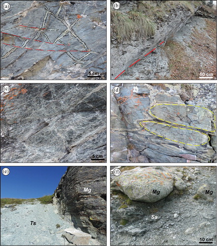
The top of the massive antigorite- and magnetite-bearing serpentinite is discontinuously characterized by meta-ophicarbonate horizons ((c)), up to ten of metres thick, which consists of ‘clasts’ of serpentinite, cm to dm in size, laced by calcite and dolomite veins. The serpentinite hosts meta-intrusives, ranging in size from decimetres rodingite dykes to hectometres elongated bodies, consisting of Mg-Al-rich metagabbro, minor Fe-Ti-rich metagabbro, Fe-rich meta-quartzdiorite and metaplagiogranite. In the NW sector of the Main Map, massive metabasalts, hundreds of metres thick, preserve relics of pillow textures ((d)), whereas in the SSE sector, they discontinuously occur as bodies of banded metabasite, tens of metres wide, with rare relics of breccia textures. Metasediments consist of clast-supported gabbroic metabreccia and of calcschist alternating to marble levels, locally associated with quartzite and quartz-rich schist.
The BSZ shows a block-in-matrix fabric (CitationBalestro, Festa, & Tartarotti, 2015) defined by blocks of metagabbro embedded in a matrix of talcschist and serpentine schist, mainly made of talc, chlorite and tremolite, and of antigorite, magnetite, talc, calcite and chrysotile, respectively ((e, f)). In the Colletto area, the occurrence of major fold hinges, tectonic contacts and faults, thickened the BSZ which results pervasively sheared, forming a weakness horizon that played a key role in the evolution of the Pui-Orgiera landslide, as described in the following.
In the upper Varaita Valley, deposits (lodgement and ablation till, erratic boulders) and landforms (lateral- and end-moraine systems, roche moutonnées) related to the Last Glacial Maximum (LGM) and recessional phases are widely present. Just downstream of the Varaita di Bellino and Varaita di Chianale rivers confluence, at the climax of the LGM, the surface of the valley glacier reached a maximum elevation of 1650–1550 m a.s.l.. As a result of the prolonged glacial erosion, valley slopes are now characterized by very steep profile below the LGM trimline (<1600 m). In the study area, two other imposing tributary glaciers originated from cirques on the southern slope of the Lobbie Peak and Rasciassa Peak, respectively. They gave rise to extensive lateral moraines up to 150 m high and extended downslope for about one kilometre (). After the rapid ice melting and retreating of the glacier fronts, diffuse landforms related to the periglacial activity developed. In the cirque areas, the production of an unusual large amount of debris at the expense of pervasively fractured metabasite and metabasalt, favoured the formation of extensive rock glaciers. Based on specific morphological and hydrogeological features such as oversteepened front, lichen cover and water spring characteristics, almost all mapped rock glaciers can be considered as inactive.
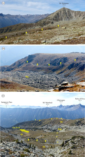
On the southern slope of the Lobbie Peak – Rasciassa Peak divide, widespread morphological features such as counter slopes, gravitational scarps and topographic depressions ((a, b)), highlight the presence of a huge deep-seated gravitational slope deformation. It is one of the largest instability phenomena of the Western Alps, involving a large part (17 km2) of the MO (see the scheme of distribution of gravitational instability phenomena in the Main Map): it extends between 2890 m a.s.l. (SW ridge of the Lobbie Peak) and the bottom of the Varaita Valley (1200 m a.s.l.). Uphill-facing scarps are the most common morphologies, typically 0.5–5 m high, and tens to hundreds of metres in length and approximately parallel or subparallel to slope contours. Although locally scarps are isolated, most of them occur in groups of several tens to hundreds of metres in width. As a consequence, double- or triple-crested ridges involve for some stretches the drainage divide between Luca Pass and Rasciassa Peak. Useful information on the relative chronology about this sackung phenomenon emerges from the relationship between morphostructural features and superficial deposits. In some cases, gravity induced landforms (mainly counter slopes) affect talus, rock fall accumulations and older glacial and late glacial deposits ((a, b)); in other cases, counter slopes are covered or sealed by periglacial deposits such as rock glaciers and gelifluction lobes ((c)).
Figure 4. (a) A 400 m long counter slope involving talus deposits of Truc Plain is visible in the foreground (yellow triangles). Photo taken from Truc Plain (2440 m), view looking SSW (Long. 7°7′54″, Lat. 44°36′48″) . (b) Impressive uphill-facing scarp (yellow triangles), 750 m long, along the eastern margin of Truc Plain. Photo taken from Traversie (2500 m), view looking SSW (Long. 7°8′5″, Lat. 44°37′17″). Rg1 indicates an inactive rock glacier. (c) Antislope scarps (yellow triangles) involving the glacial till (Gt) and the lateral moraine system of the Lobbie glacier. Notice that the inactive rock glacier (Rg1) is not displaced by gravitational collapse. Photo taken from the southern slope of the Guglie Peak (2500 m a.s.l.), view looking SSW (Long. 7°7′15″, Lat. 44°37′1″).
4. The Pui-Orgiera landslide
The Pui-Orgiera landslide is located on the southern slope of the Po-Varaita drainage divide (Lobbie Peak – Rasciassa Peak ridge). The landslide accumulation covers an area of 2.98 km2 and extends between 2,300 m a.s.l. (in the crown area) and 1050 m a.s.l. (in the valley bottom). The maximum length and width of the landslide are 3.3 and 1.3 km, respectively. Although subsurface data are lacking, a maximum thickness of 180–210 m can be extrapolated through the position of the surface rupture trace at depth (see cross section A-A’ in the Main Map), allowing to estimate a volume of about 0.45 km3 for the landslide mass. On the basis of geomorphological features, nature of the involved material, failure mechanism and age, the landslide accumulation can be divided into four sectors (Ld1–Ld4) (cf. and the Main Map), as described in the following (from the oldest to youngest), to delineate the evolutionary history of the landslide.
The sector Ld1 extends downslope the Pui village (1620 m) up to the valley bottom, between the hamlets of Confine and Villar. The landslide consists of a chaotic accumulation of clast-supported angular blocks of massive serpentinite, dm to m in size, with giant blocks up to 102–103 m3 randomly distributed within the collapsed mass ((a)). Metabasite and metagabbro blocks, coming from the crown area (il Colletto), are conspicuously concentrated near the Pui village. Ld1 can be classified as a translational rock slide that caused the collapse and total disruption of a large part of the serpentinite bedrock. This slope movement dammed the Varaita Valley with the contribution of a second complex rock slide located on the opposite side of the valley: the alluvial plain visible upstream the hamlet of Confine formed as a consequence of the blockage of Varaita River. Although the absolute emplacement age of the Ld1 sector is unknown, it must have mobilized soon after the retreat of the Varaita glacier as suggested by the deep incisions visible in the distal portion of the blocky accumulation, which agrees with an early post-glacial age of the phenomenon. Although in the central Cottian Alps the glacial chronology is poorly constrained, in the lower Susa Valley (northern sector of the Cottian Alps), the last moment of ice occupation was lately dated to 18.8 ± 2.0 ka with 10Be method (CitationIvy-Ochs et al., 2018). Much more recently, south of the Pui village, a large portion of the Ld1 was historically documented to suddenly collapsed in the year 1655, likely induced by heavy rains that triggered the downslope emplacement of a massive debris flow through the rapid disintegration of serpentine material ((a)), which buried 48 buildings and destroyed almost the entire hamlet of Villar, except for the parish church alone.
Figure 5. (a) Frontal view of the Ld1 sector of the Pui-Orgiera landslide. The Varaita River gorge is visible in the foreground. The red dashed line highlights the main scarp of the catastrophic reactivation of 1655. Photo taken from the right side of the Varaita Valley, East of Meire Gioanotta (1340 m a.s.l.), view looking NNE (Long. 7°7′43″, Lat. 44°34′40″). (b) Panoramic view of the upper part of the Pui-Orgiera landslide. Photo taken from Sampeyre Pass (2283 m a.s.l.), view looking N (Long. 7°07′09″, Lat. 44°33′04″). Ld1 to Ld4 represent the different landslide sectors. (c) Lateral view of the frontal sector of the Ld4 landslide. The impressive head scarp of the Pui-Orgiera landslide is visible in the foreground, involving the glacial till (Gt) of the Serre Plain. A large outcrop of metagabbro, meta-quartzdiorite and metaplagiogranite is visible on the right of the image. Photo taken from Croce del Gerbido (1628 m a.s.l.), view looking NW (Long. 7°8′54″, Lat. 44°35′30″).
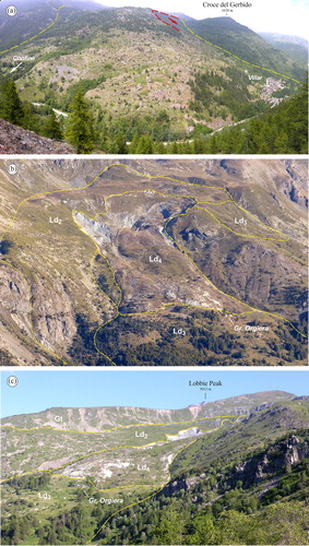
The Ld2 accumulation is dominantly a translational rock slide involving huge, semi-intact, blocks of massive serpentinite and, subordinately, metabasite and metagabbro ((b)). Ld2 is bounded to the North and North-West by an impressive head scarp up to 150–170 m high that involves the broad Serre Plain glacial plateau ((c)). This landslide was presumably generated soon after the collapse of the Ld1 sector, with a retrogressive mechanism involving ever larger portions of bedrock by multiple rotational-translational slides. Rupture surfaces correspond to numerous counter slopes and gravitational scarps, tens to hundreds of metres in length and up to 5–15 m high, and approximately parallel to slope contours, as documented in the upper part of the landslide (cf. cross-section A-A’ in the Main Map). The basal sliding surface, cropping out at the base of the main scarp, is for long stretches sealed by talus and mixed deposits resulting from the erosion of the Serre Plain glacial plateau ((c)).
The Ld3 sector is located upslope the Pui village (), and is stratigraphically juxtaposed to the Ld1 as shown by the noticeable ground bulging visible at the toe zone. The Ld3 accumulation is characterized by matrix- to (locally) clast supported chaotic deposits. The matrix is silty to sandy and ranges areally in percentage from about 50 and 80%. Its fine portion is highly sheared, showing the mixing of incoherent material made of soft, soapy aggregates of talc, chlorite and serpentine, locally with asbestos habit (Mt unit in the Main Map). Clasts are made of metagabbro and metabasite, angular to subangular in shape, and cm to dm in size. Blocks, up to 1.5–2 m wide, are randomly distributed within the collapsed material. Ld3 can be interpreted as a serpentinite flow (sensu CitationCowan & Mansfield, 1970) and characterized by intense shearing, deformation, and mixing of the involved bedrock materials.
The Ld4 sector corresponds to an impressive landslide ((b)), which, following anomalous intense snowfall (7.8 m of snow recorded from November 2008 to May 2009 at the Baracche Plain weather station, located at 2135 m a.s.l. on the right side of the Varaita Valley, 3 km South of the Pui-Orgiera landslide; CitationFratianni et al., 2015) and rapid snowmelt, started to move gradually downslope at the end of June 2009 and then accelerated rapidly few days later. Between 7 and 27 July, the landslide toe moved downslope of about 60–80 m, with a peak velocity of 4–5 m/day mostly in the period 15–25 July. Later, the velocity rapidly decreased to few cm/day. At the end of the paroxysmal phase, the rock flow travelled downslope up to 130 m and stopped just few metres from some uninhabited rural buildings of the Grange Orgiera ( (c)) ( CitationARPA Piemonte - Regione Piemonte, 2009 ). The landslide accumulation extends over an area of 0.41 km2, with highest and lowest elevation of 2159 and 1713 m a.s.l., respectively. The maximum length and width of the accumulation are about 1200 and 515 m, with a mean slope of 20.4°. There are no drill holes in the landslide area; however, at the end of paroxysmal movement, subsurface investigations (geoelectrical tomography combined with seismic refraction survey) have been made in the lower half of Ld4 (Line 1, Line 2 and Line 3 in the Main Map). Geophysical investigations detect a sharp seismic discontinuity at a depth of 40–60 m below the ground surface, which could correspond to the basal surface of the landslide. Ld4 comes from the reactivation of both the ancient Ld3 landslide and the marginal portion of Ld2. Similarly to Ld3, the involved material appears as a chaotic mixture of flaky, intensely sheared talcschist and serpentine schist, embedding subordinate angular to subangular clasts of metagabbro and metabasite. Some lenticular to rounded blocks of metagabbro, up to 8–10 m wide, are randomly distributed within the rock flow accumulation, showing characteristic polished and striated outer surfaces that result from friction between blocks and the matrix. Surface morphology of the sector Ld4 is typical of a complex rock slide – rock flow phenomenon. The central and distal portions of the landslide body flowed and expanded downslope, giving rise to a bilobate shape of the toe zone ((b)) and leading to an uplift of the original ground surface of up to 22 m. After the main body moved downslope, the crown area progressively retrogressed by means of multiple rotational slides (cross-section A-A’ in the Main Map), with a maximum subsidence in the depletion zone of about 20 m. The displaced material is superficially cut by several transverse scarplets and open cracks, whereas the two flanks of the accumulation host longitudinal pressure ridges. Finally, it is worth noting that some mud flows developed at expense of the highly water-saturated fine-grained matrix during the paroxysmal phase of the landslide emplacement. Between 2009 and 2016, a network of 19 GPS receivers installed on and around the deforming mass ( CitationARPA Piemonte - Regione Piemonte, 2009 ) recorded a horizontal rate of movement ranging from a maximum of 8.32 m (receiver R1 in the Main Map) to a minimum of 0.23 m (receiver R15). Monitoring data shows an asymptotic, gradually decreasing rate of movement, effect of long-term dehydration of the talcschist and serpentine schist of the BSZ and other lithologies involved in the Ld4 accumulation.
5. Discussion and conclusions
Our findings document that the Pui-Orgiera landslide represents an anomalous, multi-stage and long-lived mass movement, likely developed since the end of the LGM. Four distinct sectors (Ld1–Ld4) were distinguished, each of them characterized by the different combination of controlling and triggering factors and by specific failure mechanisms and kinematics. Based on the involved rocky material, morphology and types of movement, the evolution of the Pui-Orgiera landslide can be divided in two main stages.
Stage 1 : the rapid emplacement of the Ld1 rock slide, which involved the massive serpentinite originally outcropping along the valley slope between Croce D’Alie – Croce di Ciampagna and Grange Costanza, and the subsequent destabilization and collapse (with a retrogressive mechanism) of the Ld2 accumulation above the depleted zone. The slope failure likely started through the combination of (i) the intense glacial scouring and overdeepening of valley bottom, which resulted in both the increase of relief and disequilibrium of the rock slope after the rapid shrinkage of the Varaita glacier, and (ii) the occurrence of an inherited and tectonically disrupted serpentinite bedrock, including the talcschist and the serpentine schist of the BSZ, which represent a significant mechanical and rheological weakness horizon along which sliding concentrated;
Stage 2 : the removal of the basal support in the detachment area of Ld1 sector, in which the serpentinite is 20°–30° dipping toward NW (i.e. counter slope dipping), enabled overlying rocks of the BSZ to slide and flow downslope. The occurrence of material with very low shear strength, as the talcschist and serpentine schist of the BSZ, represented the main predisposing factor for Ld3–Ld4 rock flows. High levels of water saturation due to intense and prolonged precipitations (as in the July 2009) also increase pore pressure, further reducing shear strength at the base and within the reworked BSZ, triggering massive landsliding.
In conclusion, the Pui-Orgiera landslide represents the wider of several others slope instability phenomena in the MO that show causative links with serpentinite and rocks of the inherited BSZ. Our findings clearly document that the giant slide of the Ld1–Ld2 sectors of the Pui-Orgiera landslide, and the downslope flow of the Ld3–Ld4 sectors during the second evolutionary stage, are close associated to the local increase of thickening of the BSZ in the Colletto area, which resulted from the superposition of polyphasic tectonic deformation. This outlines the significant role played by inherited intra-oceanic detachment faults, such as the BSZ and similar ones, in concentrating gravitational stress and slope instability along particular mechanical and rheological weakness horizons, as also documented in other ophiolite massifs (CitationEgashira, Gibo, & Sasaki, 1992; CitationWang, Suemine, & Schulz, 2010; CitationYatabe et al., 1997). As in the MO (see CitationBalestro et al., 2018), these type of weakness horizons are commonly folded and tectonically dismembered by orogenic-related deformation, occurring at different structural levels within present-day mountain belts. The careful mapping and detailed monitoring of inherited weakness horizons is thus a significant task to mitigate mass wasting natural risks in ophiolite massifs throughout the world.
Software
The topographic map, the geological map and the related database were edited with QGIS 2.14.3 Essen, while the final map layout was edited with Adobe® Illustrator® CS5. Photos were managed and compiled using Adobe® Photoshop® CS2.
Geological map of the Pui-Orgiera serpentinite landslide (Varaita Valley, Western Alps)
Download PDF (110.2 MB)Acknowledgements
Many thanks to Michele Morelli, Jesús Guerrero Iturbe, and Bieke Cattoor for their valuable and thorough reviews and useful comments, from which we have greatly benefited in revising the manuscript and the geological map.
Disclosure statement
No potential conflict of interest was reported by the authors.
Related Research Data
References
- Alexander, E. B. , Coleman, R. G. , Keeler-Wolf, T. , & Harrison, S. P. (2007). Serpentine geoecology of Western North America . New York : Oxford University Press, 512 pp.
- Alexander, E. B. , & DuShey, J. (2011). Topographic and soil differences from peridotite to serpentinite. Geomorphology , 135 , 271–276. doi: 10.1016/j.geomorph.2011.02.007
- Amiguet, E. , Van De Moortèle, B. , Cordier, P. , Hilairet, N. , & Reynard, B. (2014). Deformation mechanisms and rheology of serpentines in experiments and in nature. Journal of Geophysical Research: Solid Earth , 119 , 4640–4655. doi: 10.1002/2013JB010791
- ARPA Piemonte - Regione Piemonte . (2009). La frana di Grange Orgiera nel Comune di Sampeyre (CN). Technical Report, 36 pp.
- Balestro, G. , Festa, A. , Borghi, A. , Castelli, D. , Gattiglio, M. , & Tartarotti, P. (2018). Role of Late Jurassic intra-oceanic structural inheritance in the Alpine tectonic evolution of the Monviso meta-ophiolite complex (Western Alps). Geological Magazine , 155 (2), 233–249. doi: 10.1017/S0016756817000553
- Balestro, G. , Festa, A. , Dilek, Y. , & Tartarotti, P. (2015). Pre-Alpine extensional tectonics of a peridotite-localized oceanic core complex in the late Jurassic, high-pressure Monviso ophiolite (Western Alps). Episodes , 38 (4), 266–282. doi: 10.18814/epiiugs/2015/v38i4/82421
- Balestro, G. , Festa, A. , & Tartarotti, P. (2015). Tectonic significance of different block- in-matrix structures in exhumed convergent plate margins: Examples from oceanic and continental HP rocks in inner Western Alps (NW Italy). International Geology Review , 57 (5-8), 581–605. doi: 10.1080/00206814.2014.943307
- Balestro, G. , Fioraso, G. , & Lombardo, B. (2011). Geological map of upper Pellice Valley (Italian Western Alps). Journal of Maps , 7 (1), 634–654. doi: 10.4113/jom.2011.1213
- Balestro, G. , Fioraso, G. , & Lombardo, B. (2013). Geological map of the Monviso massif (Western Alps). Journal of Maps , 9 (4), 623–634. doi: 10.1080/17445647.2013.842507
- Balestro, G. , Lombardo, B. , Vaggelli, G. , Borghi, A. , Festa, A. , & Gattiglio, M. (2014). Tectonostratigraphy of the northern Monviso Meta-ophiolite complex (Western Alps). Italian Journal of Geosciences , 133 (3), 409–426. doi: 10.3301/IJG.2014.13
- Bigi, G. , Castellarin, A. , Coli, M. , Dal Piaz, G. V. , Sartori, R. , Scandone, P. , & Vai, G. B. (1990). Structural model of Italy. Scale 1:500,000. Sheet N. 1. Consiglio Nazionale delle Ricerche. Progetto Finalizzato Geodinamica.
- Brandolini, P. , Nosengo, S. , Pittaluga, F. , Ramella, A. , & Razzore, S. (1999). Methodological approach in the analysis of two landslides in a geologically complex area: The case of Varenna Valley (Ligury). In R. Casale , & C. Margottini (Eds.), Floods and landslides: Integrated risk assessment (pp. 357–368). Heidelberg : Springer.
- Coleman, R. G. (1996). New Idria serpentinite: A land management dilemma. Environmental & Engineering Geoscience , 2 (1), 9–22.
- Cowan, D. S. , & Mansfield, C. F. (1970). Serpentinite flows on Joaquin Ridge, Southern Coast Ranges, California. Geological Society of America Bulletin , 81 (9), 2615–2628.
- D’Amico, M. E. , & Previtali, F. (2012). Edaphic influences of ophiolitic substrates on vegetation in the Western Italian Alps. Plant and Soil , 351 , 73–95. doi: 10.1007/s11104-011-0932-6
- Dickinson, W. R. (1966). Table Mountain serpentinite extrusion in California Coast Ranges. Geological Society of America Bulletin , 77 (5), 451–472.
- Egashira, K. , Gibo, S. , & Sasaki, K. (1992). Swelling chlorite as a possible alteration product of serpentiniziation, relating to the formation of a slip-surface in the Tochinoki landslide, Kochi. Clay Science , 8 , 221–232.
- Festa, A. , Balestro, G. , Dilek, Y. , & Tartarotti, P. (2015). A Jurassic oceanic core complex in the high-pressure Monviso ophiolite (western Alps, NW Italy). Lithosphere , 7 , 646–652.
- Fioraso, G. , Tararbra, M. , & Negro, N. (2010). The deep-seated gravitational slope deformation of Sauze d’Oulx (Western Alps): analysis of the deformation mechanisms related to the late Quaternary evolution of the upper Susa Valley. Italian Journal of Quaternary Sciences , 23 (1), 37–54. (in italian).
- Fratianni, S. , Terzago, S. , Acquaotta, F. , Faletto, M. , Garzena, D. , Prola, M. C. , & Barbero, S. (2015). How snow and its physical properties change in a changing climate alpine context? In G. Lollino et al (Ed.), Engineering Geology for Society and Territory (Vol. 1, pp. 57–60). Springer International Publishing Switzerland. doi: 10.1007/978-3-319-09300-0_11
- Guillot, S. , Schwartz, S. , Reynard, B. , Agard, P. , & Prigent, C. (2015). Tectonic significance of serpentinites. Tectonophysics , 646 , 1–19. doi: 10.1016/j.tecto.2015.01.020
- Hilairet, N. , Reynard, B. , Wang, Y. , Daniel, I. , Merkel, S. , Nishiyama, N. , & Petitgirard, S. (2007). High-pressure creep of serpentine, interseismic deformation, and initiation of subduction. Science , 318 (5858), 1910–1913. doi: 10.1126/science.1148494
- Ivy-Ochs, S. , Lucchesi, S. , Baggio, P. , Fioraso, G. , Gianotti, F. , Monegato, G. , … Schlüchter, C. (2018). New geomorphological and chronological constraints for glacial deposits in the Rivoli-Avigliana end-moraine system and the lower Susa Valley (Western Alps, NW Italy). Journal of Quaternary Science . doi: 10.1002/jqs.3034
- Kruckeberg, A. R. (1984). California serpentins: Flora, vegetation, geology, soils, and management problem . Berkeley : University of California Publications in Botany, 180 pp.
- Lee, B. D. , Graham, R. C. , Laurent, T. E. , & Amrhein, C. (2004). Pedogenesis in a wetland meadow and surrounding serpentinitic landslide terrain, northern California, USA. Geoderma , 118 , 303–320. doi: 10.1016/S0016-7061(03)00214-3
- Lombardo, B. , Rubatto, D. , & Castelli, D. (2002). Ion microprobe U–Pb dating of zircon from a Monviso metaplagiogranite: Implications for the evolution of the Piedmont-Liguria Tethys in the Western Alps. Ofioliti , 27 , 109–117.
- Phipps, S. P. (1984). Ophiolitic olistostromes in the basal Great Valley sequence, Napa County, northern California Coast Ranges. Geological Society of America Bulletin, Special Paper , 198 , 103–125.
- Piana, F. , Fioraso, G. , Irace, A. , Mosca, P. , d’Atri, A. , Barale, L. , … Vigna, G. B. (2017). Geology of Piemonte region (NW Italy, Alps-Apennines interference zone). Journal of Maps , 13 (2), 395–405. doi: 10.1080/17445647.2017.1316218
- Stark, T. D. , Newman, E. J. , de la Peña, G. , & Hillebrandt, D. H. (2011). Fill placement on slopes underlain by Franciscan Mélange. Journal of Geotechnical and Geoenvironmental Engineering , 137 (3), 263–272. doi: 10.1061/(ASCE)GT.1943-5606.0000394
- Wang, G. , Suemine, A. , & Schulz, W. H. (2010). Shear-rate-dependent strength control on the dynamics of rainfall-triggered landslides, Tokushima Prefecture. Japan Earth Surface Processes and Landforms , 35 , 407–416. doi: 10.1002/esp.1937
- Yamagishi, H. , & Ito, Y. (1994). Relationship of the landslide distribution to geology in Hokkaido, Japan. Engineering Geology , 38 , 189–203.
- Yatabe, R. , Bhandary, N. , & Okamura, M. (2007). Geotechnical perspectives of landslide mechanism in serpentine zone. Journal of the Clay Science Society of Japan (in Japanese), 46 (1), 16–23. doi: 10.11362/jcssjnendokagaku1961.46.16
- Yatabe, R. , Yagi, N. , & Yokota, K. (1997). Mineralogical and soil mechanical characteristics of landslides in serpentine belt. In P. G. Marinos , G. C. Koukis , G. C. Tsiambaos , & G. C. Stournaras (Eds.), Engineering Geology and the Environment (Vol. 1, pp. 1149–1153). Rotterdam : Balkema.