
ABSTRACT
During Quaternary glacial periods, the Šumava / Bayerischer Wald mountains were subject to mountain glaciations. Recent studies have focussed mainly on the several well-developed cirques. However, the glacial geomorphology of the mountain range as a whole has not yet been mapped from digital data. Here we use high-resolution digital elevation models to identify over 300 erosional and 40 depositional landforms of glacial origin. Our study provides a map of glacial geomorphology for the whole mountain range across the Czech Republic, Germany, and Austria, with an up-to-date overview of previously investigated sites and newly identified glacial features in areas that have not previously been surveyed. The results of our mapping study can further be validated by field surveys and will serve as a basis for future reconstructions of palaeoglaciation in the Šumava / Bayerischer Wald mountains.
1. Introduction
During the Quaternary, mid- and high-latitudes experienced glaciations both of mountain/alpine and ice sheet type (CitationEhlers, Gibbard, & Hughes, 2011). The data on the extents of glaciations are used by other disciplines, such as biology, anthropology, and palaeoclimatology. However, in many areas the extents, and also their timing, remain uncertain. The extents of glaciation are reconstructed through field surveying in combination with the use of remote sensing data; aerial photographs and digital elevation models (DEMs) are well-established types of data used for mapping the spatial distribution of glacial landforms (e.g. CitationChandler et al., 2018). The Light Detection and Ranging (LiDAR) technology has helped to significantly increase both the horizontal and the vertical resolution of DEMs over the last few years. Many countries have released detailed LiDAR DEMs recently, allowing detailed mapping of glacial landforms often in a higher detail than the mapping in the field could provide (e.g. CitationDowling, Spagnolo, & Möller, 2015; CitationHardt, Hebenstreit, Lüthgens, & Böse, 2015; CitationJónsson, Schomacker, Benediktsson, Ingólfsson, & Johnson, 2014; CitationOjala, Putkinen, Palmu, & Nenonen, 2015; CitationSalcher, Hinsch, & Wagreich, 2010; CitationYu, Eyles, & Sookhan, 2015).
The Šumava / Bayerischer Wald mountains in Central Europe represent an example of a formerly glaciated area, where no complex mapping of glacial features has been done. The recent availability of LiDAR DEMs on the territory of the Czech Republic, Germany and Austria presents a timely opportunity to carry out detailed geomorphological mapping focussed on glacial landforms in the area. The aim of this paper and the Main Map is to provide an overview of the spatial distribution of glacial features in the Šumava / Bayerischer Wald mountains. This is done by remapping previously investigated locations, filling the gaps in-between and providing a layer of digital data for future research concerned on the topic of past glaciations in the mountain range. Our mapping results can also serve as a basis for the development of conservation policy with respect to geomorphological heritage of the national parks in the area.
2. Study area
2.1. Geographical setting
The Šumava / Bayerischer Wald mountains (also known as the Bohemian and Bavarian Forest in English or Böhmerwald and Bavorský les in German and Czech respectively) is a fault-block mountain range whose main axis forms the border between the Czech Republic and Germany, as well as the main water divide between the Northern and Black seas (). The southeastern part of the mountain range belongs to Austria (). The highest peak, Großer Arber, reaches to 1456 m above sea level (asl), while the central portion of the mountains is dominated by planation surfaces with relatively low relief and a large area with an elevation over 1000 m asl (over 350 km2). As a part of the Bohemian Massif, the mountain range is composed of Variscan metamorphic and granitic rocks (CitationBabůrek, Pertoldová, Verner, & Jiřička, 2006) and its tectonic structure has been affected by the Alpine orogeny (CitationChlupáč, Brzobohatý, Kovanda, & Stráník, 2011). The natural heritage on both the Czech and German side of the border is protected by national parks: NP Šumava and NP Bayerischer Wald.
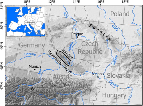
Figure 1. Location of the Šumava / Bayerischer Wald mountains. The extent of the Main Map is displayed by a black frame.
2.2. Glacial geomorphology
During the cold stages of the Pleistocene, the Šumava / Bayerischer Wald mountains were one of several isolated mountain ranges subject to glaciation in the broad ice-free corridor between the Fennoscandian Ice Sheet in the north and the glaciated Alps in the south (CitationEhlers & Gibbard, 2004). The traces of past glaciation in the Šumava / Bayerischer Wald were first described in the nineteenth century (CitationBayberger, 1886) and have been studied ever since (e.g. CitationErgenzinger, 1967; CitationHauner, 1980; CitationKřížek, Vočadlová, & Engel, 2012; CitationMentlík, Engel, Braucher, Léanni, & Team, 2013; CitationPreihäusser, 1934; CitationRaab & Völkel, 2003; CitationRathsburg, 1927; CitationReuther et al., 2011; CitationVočadlová et al., 2015; CitationVotýpka, 1979). Most of the studies, especially the most recent, have focussed mainly on some of the twelve identified cirques () or short valley-glacier locations with well-preserved glacial landforms, and dated these to the Würm period – Marine Isotope Stage (MIS) 2 (CitationMentlík et al., 2013; CitationRaab & Völkel, 2003; CitationReuther et al., 2011; CitationVočadlová et al., 2015). Calculated equilibrium line altitudes (ELAs) from the cirque locations are ranging from 925 to 1145 m asl (CitationMentlík et al., 2013; CitationRaab & Völkel, 2003), which is well below the elevation of the central summit areas (usually over 1200 m asl). In addition, there have been moraines described in lower elevations (670–890 m asl) in the valleys on the southwestern slopes of the mountains (CitationErgenzinger, 1967; CitationHauner, 1980). Based on these moraines, a hypothesis of a more extensive glaciation was proposed and described in detail by CitationErgenzinger (1967), who presented a map of glacial landforms and reconstructed an ice field based on an ELA of 1060 m asl derived from the mapped landforms. The map of Ergenzinger consists of field evidence from the German part of the mountain range exclusively and the extent of glaciation was extrapolated to the Czech territory using topographic maps. The total area of suggested ‘maximum Würm’ glacial extent is 646 km2 (CitationErgenzinger, 1967). Climatic degree-day modelling performed by CitationHeyman, Heyman, Fickert, and Harbor (2013) yielded a similar extent of glacial accumulation area for conditions with 10.7 °C lower mean annual temperatures (MAATs) than at present. More research is needed to reconstruct the glacial history of the mountain range, both in terms of the extents of the past glaciation and their chronology.
Table 1. List of the previously studied cirques in the Šumava / Bayerischer Wald mountains with references.
The glacial history of the Šumava / Bayerischer Wald mountains ties to the glacial history of the Eastern Alps located only about a hundred kilometres to the south across the Danube valley (). The extents and chronologies of the originally established glacial stratigraphy (Würm, Riss, Mindel, respectively, for the last, penultimate and antepenultimate glaciation; CitationPenck, 1882; CitationPenck & Brückner, 1901/1909) are being refined (CitationBickel, Lüthgens, Lomax, & Fiebig, 2015; CitationFiebig, Ellwanger, & Doppler, 2011; CitationPreusser, Graf, Keller, Krayss, & Schlüchter, 2011; CitationSalcher, Starnberger, & Götz, 2015; CitationVan Husen & Reitner, 2011). This presents the opportunity to study the glacial history of the Šumava / Bayerischer Wald mountains in more detail and compare the glacial histories against one another.
3. Data and methods
3.1. Data collection and mapping methodology
The Šumava / Bayerischer Wald mountains stretch across three countries: Germany, the Czech Republic, and Austria; different DEMs or DEM-derived imagery were therefore used for each of the countries. For the Czech part of the study area, the Digital Terrain Model of the Czech Republic of the 4th generation (‘DMR 4G’) was obtained from the State Administration of Land Surveying and Cadastre. These elevation data are a part of the ZABAGED Geodatabase containing detailed spatial data of the country in the scale of 1:10,000. The LiDAR-based elevation model is provided in 5 × 5 m grid with vertical random error of approximately 30 cm. On the territory of Austria, the Digital Terrain Model of Austria of 10 m resolution was used. The data were downloaded from the Land Upper Austria online portal as a 10 × 10 m grid. For the German part of the mountains we only had a hillshade image available derived from the DGM1 product produced by the Bavarian State Office for Digitization, Broadband and Surveying. The spatial resolution of the hillshade image was 1 m. In each country, the data have been analysed separately.
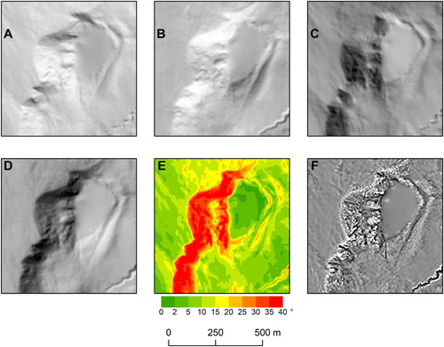
Multiple raster images for surface GIS (geographical information systems) analysis were generated from the DEMs for the Czech Republic and Austria, keeping the original spatial resolution of the DEMs. The following types of derived raster images were employed for the detection of glacial features: (1) Hillshaded relief, where the shades display breaks of slope that delineate the edges of landforms. To avoid bias arising from using illumination from one direction only (CitationSmith & Clark, 2005; CitationSmith & Wise, 2007), we used four directions of illumination: 45°, 135°, 245°, and 315°. The height of the illumination source was 45° in all cases (). The final raster images were visualised using two different range distributions: histogram-equalised, to increase the shade intensity for detecting landforms with lower relief (e.g. remnants of moraines, indistinct glacial cliffs), and minimum-maximum, to lower the contrast and let sharp glacial features stand out (e.g. pronounced glacial cliffs). For the German part of the mountains, only a hillshade with 315° direction and 45° source height was used (as we did not have the original DEM available). (2) Slope gradient, which helps to visualise the shape of landforms and to identify escarpments. Based on the study area relief, the raster was classified into the following classes: 0–2°, 2–5°, 5–10°, 10–15°, 15–20°, 20–25°, 25–30°, 30–35°, and more than 35°. (3) Contours. We used contours with 10 m vertical interval as an accessory for raster analysis. (4) Curvature. Combined plan and slope curvature was used as an accessory raster for verifying the mapped edges of landforms.
Figure 2. Examples of DEM-derived images used for the mapping: hillshaded relief with illumination direction 45° (A), 135° (B), 245° (C) and 315° (D); slope gradient in degrees (E); curvature, black: concave parts of the surface, white: convex parts of the surface (F). For the location of the area, see .
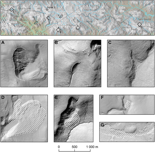
Glacial landforms in the study area were manually delineated in the above-described GIS data and classified into two main groups: (a) glacial erosion features, and (b) glacial depositional features. The glacial erosion features group contains glacially formed cliffs in three levels (): well developed (clearly visible features with certain glacial origin), poorly developed (visible features with highly probable glacial origin) and speculative (features of possible glacial origin). The glacial depositional features group contains well developed- and poorly developed moraines as well as other potential glacigenic accumulations and sandurs (). All these landforms were mapped using remote sensing data only and their origin was not verified by geomorphological and sedimentological field surveys. Hence, only clearly visible landforms showing morphologically distinct or highly probable glacial origin were mapped. In most cases, these landforms show visual similarity to the forms described in the cirque locations ().
Figure 3. Examples of glacial landforms mapped in this study: well developed (A), poorly developed (B) and speculative (C) glacial cliff; well developed (D), poorly developed (E) moraine; potential glacigenic accumulation (F); sandur (G). Locations of these examples and the example shown in are shown in the inset map.
3.2. Map creation
The Main Map is designed as a wall map in dimensions of A0 landscape format (841 × 1189 mm), with the main map panel displaying the mapped glacial landforms of the Šumava / Bayerischer Wald mountains. The main map panel is at the scale of 1:75,000 and has elevation data displayed by contours with an interval of 50 m complemented by a semi-transparent hillshade (illumination azimuth 315°, altitude 45°). Hydrographic features, summit points, and populated places are added to the map for easier orientation of the map reader. The primary content of the map (i.e. the glacial features) is depicted using distinct symbology, which is explained in the Legend. The glacial extent suggested by CitationErgenzinger (1967) is displayed as well. Ten additional maps at the scale of 1:25,000 showing thirteen best-developed glacial cirques complement the main map panel in order to display the mapped glacial features at a larger scale. The background of these maps is represented by hillshade images with 315° azimuth and 45° altitude of illumination and 10 m grid. These images have been derived from the original DEMs described in Section 3.1. Geological map depicting the lithology of the mountain range at the scale of 1:300,000 is also added to the map layout. The geological map was created by generalisation of three different national geological maps: Bavarian State Office of Geology (1996): Geological map 1:500,000, Geological Survey of Austria (2019): Geological map 1:1,000,000 and Czech Geological Survey (2007): Geological map 1:500,000. Locations of the map frames of the best-developed glacial cirques and the state borders are printed in the geological map for better orientation of the reader.
4. Mapping results, implications and conclusions
Geomorphological mapping from detailed DEMs allowed us to produce a map of glacial landforms for the whole Šumava / Bayerischer Wald mountains (see the Main Map). We remapped previously described glacial landforms () but we also present a number of newly identified glacial features in the area. Some of the newly identified features are clearly of glacial origin while for others the glacial origin is more speculative. In total, we mapped over 300 erosional and over 40 depositional landforms. The most abundant feature is a glacial cliff, in contrast to the lack of glacial depositional landforms. The mapped glacial cliffs are facing to the east in most cases. The majority of mapped features (almost all in the German part of the mountains) are located within the ‘maximum Würm’ extent of glaciation as suggested by CitationErgenzinger (1967), except for the relict sandurs. Glacial erosion features outside of the glacier extent of Ergenzinger are found in the western part of the mountains, in the westernmost area north of Ostrý Mt. (1293 m asl), and east of Můstek (1235 m asl) and Pancíř (1214 m asl), and mountains around the peak of Javorná (1090 m asl; see the Main Map). The density of glacial features decreases to the east. CitationErgenzinger (1967) suggestion of glaciers on Boubín (1362 m asl) and Bobík (1264 m asl) mountains, Almberg Mt. (1139 m asl), Grandelberg Mt. (1010 m asl), Haidel Mt. (1166 m asl), Knížecí stolec Mt. (1226 m asl), Špičák Mt. (1221 m asl) and Chlum Mt. (1192 m asl) are not supported by glacial landforms mapped in this study.
The distribution and morphology of the mapped features is consistent with the suggested climatic conditions at the time of their origin (CitationBarr & Spagnolo, 2015). The cirques and proto-cirques with different degree of development ranging from classic to marginal (sensu CitationEvans & Cox, 1995) are mainly facing to the east, which probably reflects the western winds of the glacial periods (CitationMeyer & Kottmeier, 1989; CitationRenssen, Kasse, Vandenberghe, & Lorenz, 2007) redistributing snow into leeward positions (CitationJeník, 1961). The absence of mapped features in the eastern part of the mountains can be explained by lower accumulation rates in the precipitation-shadow of the mountains. The accumulation rates were either too low to sustain the growth of glaciers in the precipitation-starved parts of the mountains or glaciers were cold-based and left no erosional traces of their existence.
Using the Last Glacial Maximum (LGM) temperatures from the available palaeoclimatic studies for the region (CitationAllen, Siegert, & Payne, 2008; CitationRamstein et al., 2007), CitationHeyman et al. (2013) modelled ice extents similar to the reconstruction of CitationErgenzinger (1967). Results of our mapping are consistent with this, identifying a number of glacial features located predominantly in the area suggested to have been glaciated (CitationErgenzinger, 1967; CitationHeyman et al., 2013). The timing and extent of the more extensive glaciation remain unclear and need to be studied further. Thus, our remote-sensing mapping survey should serve as a basis for future field-based and numerical modelling research.
The glacial geomorphology of the Šumava / Bayerischer Wald mountains is best expressed in the form of classic glacial cirques but the glacial imprint containing erosional and depositional landforms extends over most of the mountain range and indicates a relatively extensive glaciation at some point in the past.
Software
Mapping of glacial features and the DEM analyses were carried out in ArcMap 10.3 (ESRI, 2014). The final layout of the map set was produced in ArcGIS Pro (ESRI, 2017).
main_map.pdf
Download PDF (30.3 MB)Acknowledgments
We thank Tobias Heckmann for providing us the hillshade image of Bavaria. We would also like to thank Hanne Hendrickx, Matteo Spagnolo, Heike Apps and Jeremy Ely for their revisions and useful comments. The Associate Editor, Jasper Knight, and the Editor-in-Chief, Mike J. Smith, are acknowledged for their comments and editorial assistance.
Disclosure statement
No potential conflict of interest was reported by the authors.
ORCID
David Krause http://orcid.org/0000-0001-5224-8954
Martin Margold http://orcid.org/0000-0001-5834-850X
Related Research Data
References
- Allen, R., Siegert, M. J., & Payne, A. J. (2008). Reconstructing glacier-based climates of LGM Europe and Russia – Part 2: A dataset of LGM precipitation/temperature relations derived from degree-day modelling of palaeo glaciers. Climate of the Past, 4(4), 249–263. doi: 10.5194/cp-4-249-2008
- Babůrek, J., Pertoldová, J., Verner, K., & Jiřička, J. (2006): Průvodce geologií Šumavy. Prague: Czech Geological Survey.
- Barr, I. D., & Spagnolo, M. (2015). Glacial cirques as palaeoenvironmental indicators: Their potential and limitations. Earth-Science Reviews, 151, 48–78. doi: 10.1016/j.earscirev.2015.10.004
- Bayberger, F. (1886). Geographisch-geologische Studien aus dem Böhmerwalde: die Spuren alter Gletscher, die Seen und Thäler des Böhmerwaldes. Gotha: J. Perthes.
- Bickel, L., Lüthgens, C., Lomax, J., & Fiebig, M. (2015). The timing of the penultimate glaciation in the northern Alpine Foreland: New insights from luminescence dating. Proceedings of the Geologists’ Association, 126(4–5), 536–550. doi: 10.1016/j.pgeola.2015.08.002
- Chandler, B. M. P., Lovell, H., Boston, C. M., Lukas, S., Barr, I. D., Benediktsson, Í. Ö., … Stroeven, A. P. (2018). Glacial geomorphological mapping: A review of approaches and frameworks for best practice. Earth-Science Reviews, 185, 806–846. doi: 10.1016/j.earscirev.2018.07.015
- Chlupáč, I., Brzobohatý, R., Kovanda, J., & Stráník, Z. (2011). Geologická minulost České republiky. Praha: Academia.
- Dowling, T. P. F., Spagnolo, M., & Möller, P. (2015). Morphometry and core type of streamlined bedforms in southern Sweden from high resolution LiDAR. Geomorphology, 236, 54–63. doi: 10.1016/j.geomorph.2015.02.018
- Ehlers, J., & Gibbard, P. L. (Eds.). (2004). Quaternary glaciations: Extent and chronology (1st ed.). Amsterdam; San Diego: Elsevier.
- Ehlers, J., Gibbard, P. L., & Hughes, P. D. (Eds.). (2011). Quaternary glaciations - extent and chronology: A closer look. Amsterdam; Boston: Elsevier.
- Ergenzinger, P. (1967). Die eiszeitliche Vergletscherung des Bayerischen Waldes. E&G–Quaternary Science Journal, 18(1), 152–168.
- Evans, I. S., & Cox, N. J. (1995). The form of glacial cirques in the English Lake District, Cumbria. Zeitschrift für Geomorphologie, 39, 175–202.
- Fiebig, M., Ellwanger, D., & Doppler, G. (2011). Pleistocene glaciations of Southern Germany. In J. Ehlers, P. L. Gibbard, & P. D. Hughes (Eds.), Developments in quaternary sciences (Vol. 15, pp. 163–173). doi: 10.1016/B978-0-444-53447-7.00014-3
- Hardt, J., Hebenstreit, R., Lüthgens, C., & Böse, M. (2015). High-resolution mapping of ice-marginal landforms in the Barnim region, northeast Germany. Geomorphology, 250, 41–52. doi: 10.1016/j.geomorph.2015.07.045
- Hauner, U. (1980). Eiszeitliche Formen und Ablagerungen. Grafenau: Bayer. Staatsministerium für Ernährung, Landwirtschaft u. Forsten.
- Heyman, B. M., Heyman, J., Fickert, T., & Harbor, J. M. (2013). Paleo-climate of the central European uplands during the last glacial maximum based on glacier mass-balance modeling. Quaternary Research, 79(1), 49–54. doi: 10.1016/j.yqres.2012.09.005
- Jankovská, V. (2006). Late Glacial and Holocene history of Plešné Lake and its surrounding landscape based on pollen and palaeoalgological analyses. Biologia, 61(20), S371–S385. doi: 10.2478/s11756-007-0064-x
- Jeník, J. (1961). Alpinská vegetace Krkonoš, Králického Sněžníku a Hrubého Jeseníku: teorie anemo-orografických systémů. Prague: Nakladatelství Československé akademie věd.
- Jónsson, S. A., Schomacker, A., Benediktsson, ÍÖ, Ingólfsson, Ó, & Johnson, M. D. (2014). The drumlin field and the geomorphology of the Múlajökull surge-type glacier, central Iceland. Geomorphology, 207, 213–220. doi: 10.1016/j.geomorph.2013.11.007
- Křížek, M., Vočadlová, K., & Engel, Z. (2012). Cirque overdeepening and their relationship to morphometry. Geomorphology, 139–140, 495–505. doi: 10.1016/j.geomorph.2011.11.014
- Mentlík, P., Engel, Z., Braucher, R., Léanni, L., & Team, A. (2013). Chronology of the late Weichselian glaciation in the Bohemian Forest in Central Europe. Quaternary Science Reviews, 65, 120–128. doi: 10.1016/j.quascirev.2013.01.020
- Mentlík, P., Minár, J., Břízová, E., Lisá, L., Tábořík, P., & Stacke, V. (2010). Glaciation in the surroundings of Prášilské Lake (Bohemian Forest, Czech Republic). Geomorphology, 117(1–2), 181–194. doi: 10.1016/j.geomorph.2009.12.001
- Meyer, H.-H., & Kottmeier, C. (1989). Die atmosphärische Zirkulation in Europa im Hochglazial der Weichsel-Eiszeit—abgeleitet von Paläowind-Indikatoren und Modellsimulationen. E&G–Quaternary Science Journal, 39(1), 10–18.
- Ojala, A. E. K., Putkinen, N., Palmu, J. P., & Nenonen, K. (2015). Characterization of De Geer moraines in Finland based on LiDAR DEM mapping. GFF, 137(4), 304–318. doi: 10.1080/11035897.2015.1050449
- Penck, A. (1882). Die Vergletscherung der Deutschen Alpen, ihre Ursache, periodische Wiederkehr und ihr Einfluß auf die Bodengestaltung. Leipzig: J. A. Barth.
- Penck, A., & Brückner, E. (1901/1909). Die Alpen im Eiszeitalter. Leipzig: Tauchnitz.
- Pfaffl, F. (1988). Glazialmorphologische Untersuchungen am Rachel-Nordkar und am Grossen Arbersee im Bayerischen Wald. Geologische Blätter für Nordost-Bayern, 38, 7–26.
- Preihäusser, G. (1934). Über Kare und Karseen des Bayrischen Wales. Der Bayerwald, 32, 65–71.
- Preusser, F., Graf, H. R., Keller, O., Krayss, E., & Schlüchter, C. (2011). Quaternary glaciation history of northern Switzerland. Quaternary Science Journal, 60(2/3), 282–305. doi: 10.3285/eg.60.2-3.06
- Procházka, V., Mizera, J., Kletetschka, G., & Vondrák, D. (2019). Late Glacial sediments of the Stará Jímka paleolake and the first finding of Laacher See Tephra in the Czech Republic. International Journal of Earth Sciences, 108(1), 357–378. doi: 10.1007/s00531-018-1658-y
- Raab, T., & Völkel, J. (2003). Late Pleistocene glaciation of the Kleiner Arbersee area in the Bavarian Forest, south Germany. Quaternary Science Reviews, 22(5–7), 581–593. doi: 10.1016/S0277-3791(02)00090-2
- Ramstein, G., Kageyama, M., Guiot, J., Wu, H., Hély, C., Krinner, G., & Brewer, S. (2007). How cold was Europe at the Last Glacial maximum? A synthesis of the progress achieved since the first PMIP model-data comparison. Climate of the Past, 3(2), 331–339. doi: 10.5194/cp-3-331-2007
- Rathsburg, A. (1927). Die Gletscher des Böhmerwaldes zur Eiszeit. Berichte Der Naturwissenschaftlichen Gesellschaft Chemnitz, 22, 65–161.
- Renssen, H., Kasse, C., Vandenberghe, J., & Lorenz, S. J. (2007). Weichselian Late Pleniglacial surface winds over northwest and central Europe: A model–data comparison. Journal of Quaternary Science, 22(3), 281–293. doi: 10.1002/jqs.1038
- Reuther, A. U., Fiebig, M., Ivy-Ochs, S., Kubik, P. W., Reitner, J. M., Jerz, H., & Heine, K. (2011). Deglaciation of a large piedmont lobe glacier in comparison with a small mountain glacier – new insight from surface exposure dating. Two studies from SE Germany. Quaternary Science Journal, 60(2/3), 248–269. doi: 10.3285/eg.60.2-3.03
- Salcher, B. C., Hinsch, R., & Wagreich, M. (2010). High-resolution mapping of glacial landforms in the north alpine Foreland, Austria. Geomorphology, 122(3–4), 283–293. doi: 10.1016/j.geomorph.2009.09.037
- Salcher, B. C., Starnberger, R., & Götz, J. (2015). The last and penultimate glaciation in the North Alpine Foreland: New stratigraphical and chronological data from the Salzach glacier. Quaternary International, 388, 218–231. doi: 10.1016/j.quaint.2015.09.076
- Smith, M. J., & Clark, C. D. (2005). Methods for the visualization of digital elevation models for landform mapping. Earth Surface Processes and Landforms, 30(7), 885–900. doi: 10.1002/esp.1210
- Smith, M. J., & Wise, S. M. (2007). Problems of bias in mapping linear landforms from satellite imagery. International Journal of Applied Earth Observation and Geoinformation, 9(1), 65–78. doi: 10.1016/j.jag.2006.07.002
- Van Husen, D., & Reitner, J. M. (2011). An outline of the quaternary stratigraphy of Austria. Quaternary Science Journal, 60(2/3), 366–387. doi: 10.3285/eg.60.2-3.09
- Vočadlová, K., & Křížek, M. (2009). Comparison of glacial relief landforms and the factors which determine glaciation in the surroundings of Černé jezero Lake and Čertovo jezero Lake (Šumava Mts., Czech Republic). Moravian Geographical Reports, 17(2), 2–14.
- Vočadlová, K., Petr, L., Žáčková, P., Křížek, M., Křížová, L., Hutchinson, S. M., & Šobr, M. (2015). The Lateglacial and Holocene in Central Europe: A multi-proxy environmental record from the Bohemian Forest, Czech Republic. Boreas, 44(4), 769–784. doi: 10.1111/bor.12126
- Votýpka, J. (1979). Geomorfologie granitové oblasti masívu Plechého. Acta Universitatis Carolinae, Geographica, 16(2), 55–83.
- Yu, P., Eyles, N., & Sookhan, S. (2015). Automated drumlin shape and volume estimation using high resolution LiDAR imagery (curvature based relief separation): A test from the Wadena Drumlin Field, Minnesota. Geomorphology, 246, 589–601. doi: 10.1016/j.geomorph.2015.07.020