
ABSTRACT
We present a geologic map for the Eocene-Oligocene Nanchititla mafic dike swarm consisting of over 140 NNW-SSE trending dike segments; whose emplacement was influenced by the left-lateral transtensional deformation regime prevailing in southern México during the Cenozoic. The hosting rock is a mechanically heterogeneous continental sedimentary sequence interbedded with volcanic rocks. Interaction among magma and host rock promoted the formation of dike-sill systems, segmentation and sinuous intrusions. Dike thickness observed is between 1 and 45 m with a peak in the range from 1 to 5 m. Six giant dikes of more than 30 m thick were documented. The 80% of the dikes have porphyritic textures rich in plagioclase phenocrysts with size ranging from 0.5 to 2.5 cm. New and compiled 40Ar-39Ar ages constrain the swarm emplacement between 30 and 34.5 Ma, whereas plagioclase phenocrysts entrained by the magma have older ages between 35 and 42 Ma.
1. Introduction
The Nanchititla mafic dike swarm, reported as the largest and best exposed dike swarm in continental México (CitationChávez-Álvarez, Cerca, & Ferrari, 2012), is located in the eastern Michoacán state ((a)) and includes more than 140 individual dikes in a 24 km wide and 28 km long NW-SE oriented area. Previous studies show that the dike swarm represents an important magmatic episode whose emplacement is associated to extension and strike slip faulting (purple lines in (b)) in the Sierra Madre del Sur (SMS; CitationDíaz-Bravo & Morán-Zenteno, 2011; CitationMoran-Zenteno et al., 2017; CitationMorán-Zenteno, Alba-Aldave, Sole, & Iriondo, 2004). The magmatic record of the SMS migrated from W to E from the Late Cretaceous to the early Miocene at its eastern side (CitationFerrari et al., 2014; CitationMorán-Zenteno et al., 1999; CitationMorán-Zenteno, Cerca, & Keppie, 2007). At the north-central sector of the SMS a late Eocene to early Oligocene (from 36 to 30 Ma) (; and references therein) volcanic field extends WNW over an area of almost 4000 km2 and includes silicic volcanic centers of Nanchititla, La Goleta, Taxco, Tilzapotla, and Huautla ((b)) (CitationAlaniz-Álvarez, Nieto-Samaniego, Morán-Zenteno, & Alba-Aldave, 2002; CitationDíaz-Bravo & Morán-Zenteno, 2011; CitationGonzález-Torres et al., 2013; CitationMartini et al., 2009; CitationMorán-Zenteno et al., 1999; CitationMorán-Zenteno et al., 2000; CitationMorán-Zenteno et al., 2004; CitationMoran-Zenteno et al., 2017; CitationMori et al., 2012). The strike-slip deformation and extension that occurred in SMS accommodated the collapse of some late Eocene and early Oligocene WNW volcanic edifices (La Goleta and Tilzapotla volcanic centers, (b)) which are in turn coeval with the emplacement of the dike swarm (CitationMorán-Zenteno et al., 2004; CitationDíaz-Bravo & Morán-Zenteno, 2011). The Nanchititla dike swarm crops out at the eastern flank of the N-S oriented Tzitzio anticline (CitationChávez-Álvarez et al., 2012; CitationGonzáles-Cervantes, 2007; CitationSerrano-Durán, 2005). Tzitzio anticline is part of a group of N-S oriented shortening structures of Late Cretaceous to Early Paleocene ((a); CitationCerca, Ferrari, Corti, Bonini, & Manetti, 2010; CitationCerca, Ferrari, López-Martínez, Martiny, & Iriondo, 2007; CitationDelgado-Argote, López-Martínez, York, & Hall, 1992) that has an axial plane dipping steeply to the west (CitationMartini et al., 2009). The dike swarm ends abruptly against the western end of these WNM volcanic centers, where a thick package of ignimbrites (Sierra de Nanchititla in (b)) is in contact with Oligocene lavas that rest over the sedimentary sequence that is cut by the dike swarm. Many of the Nanchititla dikes intrude a thick sequence of the Cutzamala formation of about 2500 m of conglomerates, sandstones, and shale redbeds, deposited in continental fluvial and lacustrine environment in Campanian to early Eocene times. Dikes composition is mafic calc-alkaline basaltic and andesitic-basaltic rocks with dark green to gray color (CitationSerrano-Durán, 2005). They show mainly intergranular, intersertal, and glomeroporfidic textures characterized by important plagioclase mega phenocrysts content ((a–c)), although aphanitic textures are also observed. The plagioclase mega phenocrysts are anorthites and bytownites commonly over 2.5 cm in length and have a volumetric percentage of up to 60% in the dikes. Plagioclase mega phenocrysts are common in basaltic lavas from spreading ridges, intraplate hotspots and flood basalts (e.g. CitationCullen, Vicenzi, & McBirney, 1989; CitationFurman, Frey, & Park, 1991; CitationHiggins & Chandrasekharam, 2007). However, their transport dynamics through the sub-volcanic plumbing systems and how it controls their distribution in the surface remains unknown. Here, we present a detailed field study of the distribution of plagioclase mega-phenocrysts bearing magma through dikes. We present a map of plagioclase size distribution in dikes from the Nanchititla dike swarm along with observations of geomorphological features of these intrusions (Main Map). The data were obtained from field observations, laboratory, data analysis and an updated compilation of isotopic ages, including five new 40Ar/39Ar ages, as well as the integration of geological cartography derived from previous works, original mapping, and photointerpretation.
Figure 1. Schematic map showing the location of the Nanchititla dike swarm and the geological setting. (a) The Nanchititla dike swarm is located in the eastern Michoacán state. (b) The mapped dike swarm inside the red square is located at the western end of a regional lineament of Eocene-Oligocene volcanic centers and left lateral faulting indicated by NW-SE purple lines in the map (CitationMorán-Zenteno et al., 2007). Shortening structures with N-S axis in grey lines appear at both sides of the studied area.
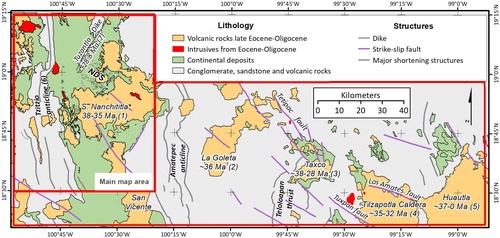
Figure 2. A view of the two main structures that limit the Nanchititla dike swam at the east and west side. (a) N-S section of the Tzitzio anticline in contact with the red beds that host the Eocene-Oligocene dikes. (b) A west to east view of Sierra de Nanchititla, constituted by a thick package of ignimbrites in contact with Oligocene lavas that rest unconformably on the red bed sequence.
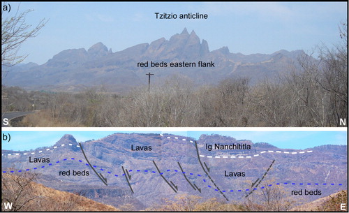
Figure 3. Dike outcrop showing typical porphyritic textures with high plagioclase phenocrysts content. In (a) the dike-host rock contact is observed, the circle in blue enclosed a section of dike rock in situ that contains giant plagioclase phenocrysts. Photograph (b) is a close up of the area in the blue circle that shows individual plagioclase phenocrysts and glomeroporphyritic clots of plagioclase. (c) The groundmass shows an intersertal texture, here is shown a close view of plagioclase phenocryst twinning. (d) Rocks were classified according to the phenocrysts size distributions calculated with CSD Corrections from CitationHiggins (2000). The calculation of Crystal Size Distribution uses geometric parameters of an ellipse (white line) that approximates to the 2D phenocrysts outlines (light blue line).
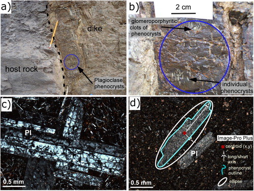
Table 1. A summary of geochronological data that includes new, recalculated and previously reported ages for Nanchititla dikes and other magmatic units.
2. Methods and tools
2.1. Field methods
The traces of the Nanchititla dikes are continuously exposed from few meters up to several kilometers. The erosion of the host rock exposes a vertical section of approximately 700 m from 380 to 1051 m.a.s.l. Field-work involved the observation of dike outcrops at 149 sites where structural data and rock samples were collected. Each location was recorded using a GPS in UTM coordinates using WGS84 datum. The strike and dip of dike walls, fractures, folds, and host rock planes were measured using a Freiberg compass. Geometrical features of dikes such as thickness and wall shape were measured directly in outcrops with a measuring tape and photographed using a digital camera. Rock samples were collected in most of the sites for textural and crystal size distribution analysis. Petrographic description was made on thin sections.
2.2. 40Ar-39Ar geochronology
Five representative and unaltered samples of dikes were dated by the 40Ar-39Ar step-heating method. We dated plagioclase phenocrysts and groundmass proceeding from both phenocryst-poor and phenocryst-rich dikes in four samples. Groundmass and plagioclase concentrate with purity larger than 99% were analyzed at the Geochronology Lab of Department of Geology, CICESE, using a VG5400 mass spectrometer and a laser gas extraction system. Samples were irradiated at the nuclear reactor of the University of McMaster in Hamilton, Ontario, Canada, using as monitor of irradiation two known-age samples of sanidine, FCT-2 of 27.84 ± 0.04 Ma (CitationKuiper et al., 2008) and TCR-2 of 27.87 ± 0.04 Ma (CitationRenne et al., 1998). Experiments were made by step-heating the samples, increasing the laser power from 1 to 14 watts and measuring the isotopic composition of argon released during each step. More details of the 40Ar-39Ar technique are explained in CitationOchoa-González, Carreon-Freyre, Cerca, and López-Martínez (2015) and CitationBonini et al. (2017). The age was calculated for each individual fraction adding individual steps in accordance with CitationHall (1981). Corrections by discrimination, radioactive decay (CitationSteiger & Jäger, 1977), background line, and interference reactions (from isotopes derived from Ca, Cl, and K) were considered. Straight-line calculation was performed with the equations presented by in CitationYork, Evensen, López-Martínez, and De Basabe-Delgado (2004). Errors are reported at 1σ level. Errors for integrated, plateau, isochron, and weighted mean ages include the uncertainty in the J parameter. Plateau ages were calculated using the weighted mean of three or more consecutive fractions, which agreed within 1σ errors excluding the uncertainty in J. When a plateau could not be computed, the age correlations (tc) were used. 40Ar*/39ArK correlation diagrams are given by the inverse of the intercept of the line defined by the data and is equivalent to the age in Ma.
2.3. Phenocrysts size distribution analysis
Rock samples of 32 dikes were cut in cubes of at least two perpendicular plane sections of 25 cm2 exposing the porphyritic textures. Gray scale photographs were recorded for each exposed rock plane in cubes and in outcrop. This resulted in 113 planes in which the distribution of sizes from plagioclase mega phenocrysts were determined through a crystal size distribution (CSD) analysis following the method of CitationHiggins (2000, Citation2002). This is a method for stereo corrections of CSD through measurements of crystal outlines observed in 2D planes, such as length, width, area, perimeter, orientation, and crystal centroid location. Phenocrysts outlines were delimited by polygons drawn in Image-pro Plus ((d)). The values of the length, width, area, perimeter, orientation, and centroid location of phenocrysts were obtained automatically for a best-fit ellipsoid from each drawn polygon using the count/size tool in Image-pro Plus. These parameters were imported to the CSD correction program by CitationHiggins (2000, Citation2002) that estimates the approximate 3D crystal size distribution. For simplicity, it was considered there was an absence of phenocrysts preferred orientation, thus the small and long axis determined from the approximated ellipses are considered close to S/I (CitationHiggins, 1994). The aspect ratio of the phenocrysts was simplified by considering I = L (CitationHiggins & Chandrasekharam, 2007). We observed that the apparent aspect ratios between length and width of the best-fit ellipsoids approximated to the phenocrysts outlines are from 1:2 to 1:9. Since our 2D values are similar to those obtained by Higgins we consider to apply the same 3D ratio of 1:5:5, with the advantage of a direct comparison between the results. Most of the plagioclase phenocrysts are anorthite and bytownite with tablet geometry. The values of the long dimensions calculated for the phenocrysts obtained from the plots of size distribution (CitationHiggins, 2000) were used to classify the textures of the Nanchititla dikes in four groups: G, M, N and NV. The size distribution plots might include a broad range of sizes due to the polydisperse nature of the phenocrysts population. The range of sizes of each group was selected arbitrarily as follows: G type textures for plagioclase lengths are above 2.5 cm, M type textures for values between 0.5 and 2.5 cm, N type textures for lengths minor to 0.5 cm and NV for aphanitic textures.
2.4. Map compilation
We compiled previous geologic maps of the studied area (CitationChávez-Álvarez et al., 2012; CitationGonzáles-Cervantes, 2007; CitationMennella, Garduño-Monroy, & Bonassi, 2000; CitationSerrano-Durán, 2005) into six INEGI 1:50000 scale topographic sheets (Tuzantla, E14A45; Bejucos, E14A55; Tiquicheo, E14A54; Limon de Paptzindan, E14A44; Palmar Chico, E14A65; and Huetamo, E14A64) in the CEM3.0 digital elevation model (DEM) from ‘Instituto Nacional de Estadística, Geografía e Informática’ (INEGI). The compiled database along with the new field and lab data was imported into shapefile format. Map layout, as well as geo-referencing and digitization of structural elements such as the main faults traces, synclines, anticlines and dike traces, was completed in 1:100,000 scale using ESRI© ArcGIS 10.5. The traces of more than 100 dikes were mapped from image analysis and field verification. The classes of the mean size of plagioclase phenocryst from 115 rock samples were included in the Main Map.
2.5. Results and discussion
2.5.1. 40Ar-39Ar geochronology of the Nanchititla dike swarm
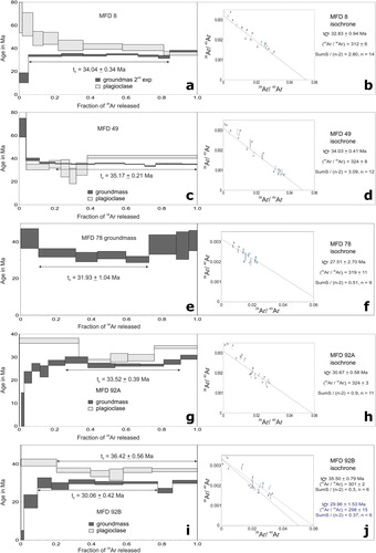
The age of the Nanchititla mafic dike swarm was constrained by five new 40Ar-39Ar ages and 20 ages compiled from previous works (; supplementary Table S1 and ) (CitationDíaz-Bravo & Morán-Zenteno, 2011; CitationGómez-Vasconcelos, Garduño-Monroy, Macías, Layer, & Benowitz, 2015; CitationGonzáles-Cervantes, 2007; CitationMartini et al., 2009; CitationSerrano-Durán, 2005). Preferred ages are indicated in . The 40Ar/39Ar age for sample MFD8 yielded a plateau age for the groundmass of 34.50 ± 0.37 Ma and for plagioclase of 41.93 ± 1.66 Ma ((a)), with similar isochrone age ((b)). For sample MFD49 the isochrone ages yielded 31.80 ± 1.62 Ma for the groundmass and 34.57 ± 0.50 Ma for the plagioclase phase ((c,d)). In the case of sample MFD78 only the groundmass was dated yielding a preferred plateau age of 32.39 ± 1.07 Ma ((e)). For dike MFD92 two samples were collected corresponding to different textures that we have interpreted as a multiple intrusion along the same structure. Sample MFD92A yielded a plateau age for the groundmass of 33.95 ± 0.40 Ma and a similar isochrone age ((g,h)). The plagioclase phase from this dike yielded a tp age of 36.40 ± 0.85 Ma computed using 42% of the radiogenic argon extracted. Sample MFD92B yielded a plateau age of 30.45 ± 0.45 Ma and a plateau age of 36.92 ± 0.58 Ma for the plagioclase phase ((i,j)). Ages compiled for the dike swarm showed similar results. In the case of the ages made by CitationSerrano-Durán (2005), LS 42 dike yielded an isochrone age of 35.02 ± 1.02 Ma for the groundmass and a statistically undistinguishable plateau age of 34.97 ± 4.30 Ma for the plagioclase phenocrysts. Dike sample BEJ-9 yielded 36.26 ± 0.51 Ma for hornblende. For whole rock samples, those from CitationSerrano-Durán (2005) yielded plateau ages of 38.17 ± 0.63 (LS 3) and 37.59 ± 0.63 Ma (TC 05); whereas CitationGonzáles-Cervantes (2007) reported 36.79 ± 0.44 Ma (NAN 64) and 35.65 ± 0.33 (NAN 68) for lava and dike samples, respectively. We consider that the anomalously old age of whole rock samples represents a mixture of the age of the phenocrysts and the groundmass. Overall, we interpret our results as the age of emplacement of the dike swarm varying from ca. 34.5 to 30 Ma, i.e. the ages of the groundmass, and that the phenocrysts phase has older ages between 42 and 35 Ma that represent the phases dragged out in the magma flow from its source.
Figure 4. 40Ar-39Ar age spectra, preferred age and inverse correlation diagram; respectively, for samples: (a and b) MFD 8, (c and d) MFD 49, (e and f) MFD 78, (g and h) MFD 92A, (i and j) MFD 92B. Geochronologic data and sample location are reported in . When available duplicate experiments on different mineral phases are indicated. Dating was performed at the Laboratorio de Geocronología of CICESE (Centro de Investigación Científica y Educación Superior de Ensenada Baja California). Acronyms: tp, plateau age; tc, inverse correlation diagram age.
The case of the Tuzantla dike contrast with the dike swarm not just in its oblique orientation with respect to the main dike trend but also its age. The age reported by CitationGómez-Vasconcelos et al. (2015) for groundmass of Tuzantla dike yielded an isochrone age of 28.8 ± 0.6 Ma (TUZ-01), whereas the plagioclase phenocrysts yielded and Ar-Ar age of 24.55 ± 1.55 Ma (LS 84) and a K-Ar age of 34.8 ± 1.1 Ma (CitationSerrano-Durán, 2005). This large difference in age illustrates the difficulty of dating the phenocrysts-bearing dikes in the zone.
The age of the volcanism in the surrounding region has been reported in a range from 43 to 24 Ma (). Oldest Tertiary magmatism recorded in the area is related to the emplacement of the Purungueo dacitic dome of 43.11 ± 1.37 Ma located to the west of the dike swarm (sample TC 07; CitationSerrano-Durán, 2005) and the basal lava flows of the silicic Nanchititla volcanic field with ages of 43.40 ± 2.80 Ma (sample TC 01; CitationGonzáles-Cervantes, 2007). Further south there are reports of dacites and intrusives within the same Eocene age, i.e. the dacitic rock sample M 29-9-1 with an age of 43.23 ± 0.45 Ma and the granodiorite sample M 15-2-4 with an age of 45.72 ± 0.30 (CitationMartini et al., 2009). These results suggest a subvolcanic episode in the region between ca. 46 and 43 Ma, represented in the studied area by the Purungueo dome.
Silicic ignimbrites of the Nanchititla and Sultepec – La Goleta volcanic fields located to the east of the Nanchititla swarm occurred at an age closer to the dikes. Namely, the age reported for the sample TC 02 (CitationGonzáles-Cervantes, 2007) of 36.23 ± 0.52 Ma, 35.15 ± 0.44 Ma and 36.17 ± 0.55 Ma for ignimbrite samples GO 05 and GO 372-07, respectively (CitationDíaz-Bravo & Morán-Zenteno, 2011); and 36.60 ± 1.10 Ma for a sample GO 01-04 from a pyroclastic dike associated to emplacement of the ignimbrite (CitationDíaz-Bravo & Morán-Zenteno, 2011). In the Ciudad Altamirano region located to the south of the studied area, it was reported an age of 37.21 ± 0.56 Ma (CitationMartini et al., 2009) for an ignimbrite rock sample (M 15-2-3). In addition to this, two more ages have been reported for a subvolcanic and intrusive bodies in the Nanchititla volcanic field (CitationGonzáles-Cervantes, 2007), yielding ages of 36.74 ± 0.19 Ma for an hypabissal diorite rock (sample TC 04) and 36.10 ± 0.16 Ma for a granite rock (sample NAN 55). In conclusion, these data suggest that a short time magmatic silicic pulse occurred between ca. 37 and 35 Ma.
2.5.2. Morphological features of dikes
The Nanchititla dikes dip 74° on average and follow a dominant NW-SE trend. Six giant dikes of more than 30 m wide, and trending WNW-ESE, are distributed in three parallel bands at the northern, central and southern parts of the dike swarm (Main Map). The dike traces are parallel to slightly oblique with respect to the six giant dikes (rose diagram in (a)) with thickness ranging between 1 and 45 m with an average thickness of 6.96 m. (Plot in (h)), and a peak in the range from 1 to 5 m. The notable exception to the general trend is the giant Tuzantla dike, a 32 m wide intrusion that can be followed for at least 18 km in an NNE-SSW orientation.
Figure 5. Distribution of dike orientation and thickness in the Nanchititla dike swarm (a and b). Some dikes have planar and tabular geometries as shown in (c). Photograph (d), (e) and (f) are examples of finger-like dike intrusions are a single segment or several segments formed from the main dike intrusion. Dike-sill systems were also observed at different levels of the host rock as shown in incise (g) and (h).
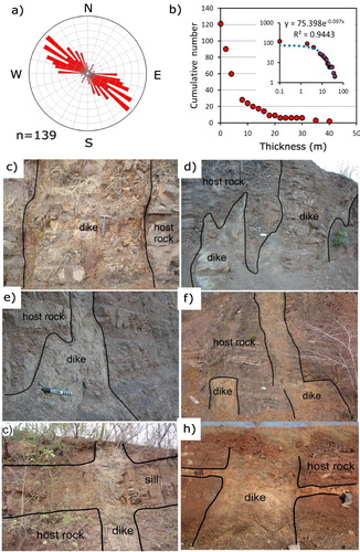
The cumulative frequency distribution of dikes (Main Map) shows that the number of dikes decreases as they become thicker. The log–log plot in the inset ((b)) shows that dike thickness follows a power law distribution, a behavior commonly observed in other dike populations emplaced in different tectonic settings (e.g. CitationCurtis, Riley, Owens, Leat, & Duncan, 2008; CitationGudmundsson, 1995).
Nanchitila dikes show contrasting morphologies in the exposed column of the Cutzamala sequence. Most of the dikes are characterized by well-defined planar walls emplaced as sheet intrusions ((c)), although at some levels dikes emplaced following sinuous paths that in some cases were segmented in two or more finger-like intrusions ((d–f) and supplementary table S2). This can be indicative that host rock behaved as a ductile material due to its particular rheological profile or due to thermal erosion (e.g. CitationKavanagh & Sparks, 2011) that promotes a ductile flow processes (e.g. CitationMagee et al., 2019). Dike-sill systems ((g,h)) are observed at the same stratigraphic level of sinuous and finger-like intrusions in close association with strength contrast contacts between relatively rigid (sandstone, conglomerate) and soft (siltstones, shale) host rocks (e.g. CitationKavanagh, Menand, & Sparks, 2006). All sinuous intrusions and dike sill systems occur along NW-SE trending dikes comprised between the bands of WNW-ESE trending giant dikes. They are no wider than 16 m, with the most common range of thickness from 0.1 to 5 m.
2.5.3. Transport of plagioclase mega phenocrysts magmas in Nanchititla dikes
The 80% of the dikes analyzed are rich in plagioclase phenocrysts of a broad range of sizes. These porphyritic textures were classified on the basis of their 3D approximated phenocrysts sizes as N, M and G according to their markedly difference of the phenocrysts size distribution ((a) and ). The plot of population density versus size is a key output from CSD analysis that supported the arbitrary limits used to idealize the three types of textures that we considered in our dike classification ((b)).
Figure 6. Rock samples that show the contrasting plagioclase phenocrysts size content in Nanchititla dikes. N, M, G and Nv classification is based on the results of Cristal Size Distribution Analysis made for these rocks using the method of CitationHiggins (2000). Nv is aphanitic texture Most of the dikes have porphyritic textures being the N type (Pl < 0.5 cm) the most abundant.
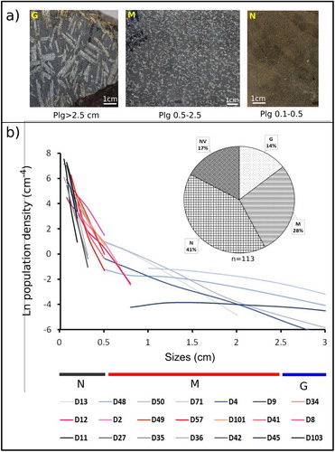
Figure 7. Percentage of dikes with G, M, N and NV type rocks in different range of dike thickness. The percentage was normalized to the maximum number of dikes observed in each range.
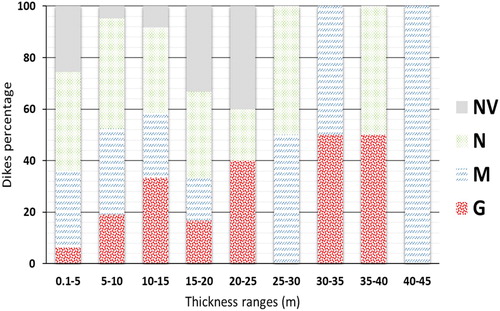
Although the data is limited to the dikes observed at the surface, N-type rocks (with the smallest phenocryst of sizes <0.5 cm, and ) were found distributed from north to south of the dike swarm. In the central area is notable the absence of aphanitic rocks (NV type) that in general represents the 17% of dikes observed (). NV type rocks were observed at the northern and southern portions of the dike swarm, having a remarkable presence in a band located near Tiquicheo locality (Main Map). M type rocks were observed mainly at the north of swarm, and less often to the south, with few cases at the south west and north west of Zacapuato locality. G type rocks rich in mega phenocrysts were observed scarcely at the northern and southern parts of the swarm, being more abundant in the central part. Both rich and poor plagioclase phenocrysts magmas were transported through dikes of different thicknesses, most of them associated with pre-existing faults. In particular, aphanitic rocks were found in dikes from 0.1 to 25 m thick (), being more abundant in the range of thickness between 15 and 25 m. In contrast, magmas rich in plagioclase phenocrysts were observed in dikes with a broad range of thickness, from 0.1 m and up to 45 m thick. Most of the dikes thickness are in the range of 0.1–15 m and have G, M, N and NV rock types with predominance of plagioclase phenocrysts of N type, 0.5 cm long (); however, the proportion of G and M type rocks increase with thickness. This implies that the thicker dikes of the swarm extracted magmas rich in mega-phenocrysts sizes.
3. Probable causes of plagioclase phenocrysts distribution
The extraction of magma carrying all different sizes of plagioclase phenocrysts took place in the zone is suggested by the distribution of giant dikes of N, M, and G type textures. The complex configurations of dike intrusions, i.e. dike-sill systems and en echelon dikes, suggest that these intrusions change their trajectory due to a rotation of the local stress direction, probably introduced by variations of the host rock competence (e.g. CitationChávez-Álvarez et al., 2012; CitationKavanagh et al., 2006). Less competent silt and clay-bearing host rock correspond usually to plastic behavior that might have allowed formation of dikes with sinuous trajectories and finger terminations.
The size of plagioclase phenocrysts in mafic magmas is related with the time of residence in a magma reservoir and its rate of growth, which depends of the available water content and mineral resources in the immediate border (e.g. CitationCashman & Marsh, 1988; CitationHiggins & Chandrasekharam, 2007; CitationZellmer, Blake, Vance, Hawkeswoth, & Turner, 1999). Phenocrysts growth rate calculated from CSD analysis for undercooling conditions in magma reservoirs are between 10−10 and 10−9 mm/s (e.g. CitationCashman, 1993; CitationCashman & Marsh, 1988; CitationHiggins, 2006). This range includes growth rates for lava flow that are around 10−9 mm/s and growth rates in magma reservoirs between 10−11 to 10−10 mm/s depending on crustal depth. If we consider that the plagioclase phenocrysts in the Nanchititla dike swarm developed at the same rate, size variations for the plagioclase phenocrysts of the dike swarm suggest a difference in the residence time on the order of millions of years. In our case, phenocrysts 42–35 Ma old were entrained from different magma sources in the crust by basaltic magmas of 35–30 Ma. Dikes might have been fed by several reservoirs where plagioclase phenocrysts developed. Alternatively, the mega phenocrysts could have been entrained from pre-existing intrusive rocks.
4. Conclusions
A geological map of the Nanchititla mafic dike swarm and its hosting rocks is presented. This is the largest continental mafic dike swarm reported in México representing an important Eocene to Oligocene magmatic episode in the Sierra Madre del Sur. The NW-SE preferred alignment of the dike traces in the Nanchititla swarm suggests a strong tectonic influence in their emplacement. The emplacement of dikes is partially coeval with extension and strike-slip faulting and the regional alignment of volcanic centers reported in southern México. The map shows dikes with long and parallel lineal traces with nearly vertical walls. Complex dike geometries observed at the outcrop scale, such as dike-sill systems, en echelon dikes, sinuous and finger-like intrusions, suggest that local variations of the host rock competence change the stress orientations. Six giant dikes of more than 30 m thick were documented, they are distributed in three parallel bands. The 80% of the dikes within the swarm are rich in broad range of plagioclase phenocrysts sizes. The aphanitic groundmass ages obtained constrain the age of emplacement of the dike swarm between 30 and 34.5 Ma. Plagioclase mega phenocrysts dragged by the magma in general have older ages between 35 and 42 Ma. Previous whole rock ages of the dikes yielded anomalous ages illustrating the difficulties found for dating dike systems. The Nanchititla dike swam is the best exposed mafic dike swam in México, representing a natural laboratory to study the feeder system of the late Eocene-Oligocene volcanism in the SMS.
Software
Geo-referencing and digitization of map elements was made using ESRI© ArcGIS 10.5. Data collected from previous works such as rock data ages, structural data and morphological aspects of dikes along with the data obtained from the textural analysis made for this paper were input in Excel files. CSD-correction software by CitationHiggins (2000) was used to calculate the true value of plagioclase phenocrysts. Image-Pro Plus was used to analyze the 2D phenocrysts intersections and evaluate the geometrical parameters of the phenocrysts outlines. Figures and photographs were editing using common image editing and drawing software, Canvas GFX© Canvas X Pro 16 and Corel© Corel Draw 2017. Database for this manuscript is available at DOI: 10.17632/85vtm52jsm.1.
The Eocene-Oligocene Nanchititla dike swarm, eastern Michoacan, Mexico
Download PDF (38.4 MB)Acknowledgements
Lina Serrano-Durán, Norma González, Michelangelo Martini, and Rodrigo Portillo are thanked for their participation in some part of the fieldwork. Ricardo Carrizosa and Alejandro Sólis Sánchez helped with the rock sample cutting and photographic record. Photographs from outcrops and samples were processed using image edition software. Vicente Torres-Rodríguez did a detailed revision for supplemental map and gave us cartographic feedback. We acknowledge the revision of Heike Apps, Craig Magee and Julio Cesar Horta de Almeida, and of the associate editor Claudio Riccomini that helped to clarify the manuscript.
Disclosure statement
No potential conflict of interest was reported by the authors.
Additional information
Funding
Related Research Data
References
- Alaniz-Álvarez, S. A. , Nieto-Samaniego, A. F. , Morán-Zenteno, D. J. , & Alba-Aldave, L. (2002). Rhyolitic volcanism in extension zone associated with strike-slip tectonics in the Taxco region, southern México. Journal of Volcanology and Geothermal Research , 118 , 1–14. doi: 10.1016/S0377-0273(02)00247-0
- Bonini, M. , Cerca, M. , Moratti, G. , López-Martínez, M. , Corti, G. , & Gracia-Marroquín, D. (2017). Early Miocene contractional deformation in the lower Comondú Group in Baja California Sur (México). Tectonophysics, 719–720, 135–147. doi:10.1016/j.tecto.2017.05.032 .
- Cashman, K. V. (1993). Relationship between plagioclase crystallisation and cooling rate in basaltic melts. Contributions to Mineralogy and Petrology , 113 , 126–142. doi: 10.1007/BF00320836
- Cashman, K. V. , & Marsh, B. D. (1988). Crystal size distribution (CSD) in rocks and the kinetics and dynamics of crystallization II: Makaopuhi lava lake. Contributions to Mineralogy and Petrology , 99 (3), 292–305. doi: 10.1007/BF00375363
- Cerca, M. , Ferrari, L. , Corti, G. , Bonini, M. , & Manetti, P. (2010). Inversion tectonics of the heterogeneous lithosphere of southwestern México during Laramide shortening. Lithosphere , 2 (3), 172–187. doi: 10.1130/L48.1
- Cerca, M. , Ferrari, L. , López-Martínez, M. , Martiny, B. , & Iriondo, A. (2007). Late Cretaceous shortening and early Tertiary shearing in the central Sierra Madre del Sur, southern México: Insights into the evolution of the Caribbean–North American plate interaction. Tectonics , 26 , 26, 1–34, TC3007. doi:10.1029/2006TC001981 .
- Chávez-Álvarez, M. J. , Cerca, M. , & Ferrari, L. (2012). Physical and geological description of the Nanchititla dike swarm. Revista Mexicana de Ciencias Geológicas , 29 (3), 551–571.
- Cullen, A. , Vicenzi, E. , & McBirney, A. R. (1989). Plagioclase-ultraphyric basalts of the Galapagos Archipelago. Journal of Volcanology and Geothermal Research , 37 , 325–337. doi: 10.1016/0377-0273(89)90087-5
- Curtis, M. L. , Riley, T. R. , Owens, W. H. , Leat, P. T. , & Duncan, R. A. (2008). The form, distribution and anisotropy of magnetic susceptibility of Jurassic dikes in H.U. Sverdrupfjella, Dronning Maud Land, Antarctica. Implications for dike swarm emplacement. Journal of Structural Geology , 30 , 1429–1447. doi: 10.1016/j.jsg.2008.08.004
- Delgado-Argote, L. , López-Martínez, M. , York, D. , & Hall, C. (1992). Geologic framework and geochronology of ultramafic complexes of southern México. Canadian Journal of Earth Sciences , 29 , 1590–1604. doi: 10.1139/e92-125
- Díaz-Bravo, B. A. , & Morán-Zenteno, D. J. (2011). The exhumed Eocene Sultepec-Goleta Volcanic Center of southern México: Record of partial collapse and ignimbritic volcanism fed by wide pyroclastic dike complexes. Bulletin of Volcanology , 73 (7), 917–932. doi: 10.1007/s00445-011-0460-5
- Ferrari, L. , Bergomi, M. , Martini, M. , Tunesi, A. , Orozco-Esquivel, M. , & López Martínez, M. (2014). Late Cretaceous – Oligocene magmatic record in southern México: The case for a temporal slab window along the evolving Caribbean-North America-Farallon triple boundary. Tectonics , 33 , 1738–1765. doi: 10.1002/2014TC003525
- Furman, T. , Frey, F. A. , & Park, K.-H. (1991). Chemical constraints on the petrogenesis of mildly alkaline lavas from Vestmannaeyjar, Iceland; the Eldfell (1973) and Surtsey 1963–1967) eruptions. Contributions to Mineralogy and Petrology , 109 , 19–37. doi: 10.1007/BF00687198
- Gómez-Vasconcelos, M. G. , Garduño-Monroy, V. H. , Macías, J. L. , Layer, P. W. , & Benowitz, J. A. (2015). The Sierra de Mil Cumbres, Michoacán, México: Transitional volcanism between the Sierra Madre Occidental and the Trans-Mexican Volcanic Belt. Journal of Volcanology and Geothermal Research , 301 , 128–147. doi: 10.1016/j.jvolgeores.2015.05.005
- Gonzáles-Cervantes, N. (2007). Evolución del centro silícico de la Sierra de Nanchititla Edo. de México y Michoacán (Master thesis). UNAM, Centro de Geociencias, México.
- González-Torres, E. A. , Morán-Zenteno, D. J. , Mori, L. , Díaz-Bravo, B. , Martiny, B. M. , & Solé, J. (2013). Geochronology and magmatic evolution of the Huautla volcanic field: Last stages of the extinct Sierra Madre del Sur igneous province of southern México. International Geology Review , 55 (9), 1145–1161. doi: 10.1080/00206814.2013.767504
- Gudmundsson, A. (1995). Infrastructure and mechanics of volcanic systems in Iceland. Journal of Volcanology and Geothermal Research , 64 , 1–22. doi: 10.1016/0377-0273(95)92782-Q
- Hall, C. M. (1981). The application of K-Ar and 40Ar/39Ar methods to the dating of recent volcanics and the Laschamp event (PhD thesis). University of Toronto, Canada.
- Higgins, M. D. (1994). Determination of crystal morphology and size from bulk measurements on thin sections: Numerical modelling. American Mineralogist , 79 , 113–119.
- Higgins, M. D. (2000). Measurement of crystal size distributions. American Mineralogist , 85 (9), 1105–1116. doi: 10.2138/am-2000-8-901
- Higgins, M. D. (2002). Closure in crystal size distributions (CSD), verification of CSD calculations, and the significance of CSD fans. American Mineralogist , 87 (1), 171–175. doi: 10.2138/am-2002-0118
- Higgins, M. D. (2006). In quantitative textural measurements in igneous and metamorphic petrology (pp. I-Vi) . Cambridge : Cambridge University Press.
- Higgins, M. D. , & Chandrasekharam, D. (2007). Nature of sub-volcanic Magma Chambers, Deccan Province, India: Evidence from quantitative textural analysis of plagioclase megacrysts in the Giant Plagioclase Basalts. Journal of Petrology , 48 (5), 885–900. doi: 10.1093/petrology/egm005
- Kavanagh, J. L. , Menand, T. , & Sparks, R. S. J. (2006). An experimental investigation of sill formation and propagation in layered elastic media. Earth and Planetary Science Letters , 245 (3–4), 799–813. doi: 10.1016/j.epsl.2006.03.025
- Kavanagh, J. L. , & Sparks, R. S. J. (2011). Insights of dike emplacement mechanics from detailed 3D dike thickness datasets. Journal of the Geological Society , 168 (4), 965–978. doi: 10.1144/0016-76492010-137
- Kuiper, K. F. , Deino, A. , Hilgen, F. J. , Krijgsman, W. , Renne, P. R. , & Wijbrans, J. R. (2008). Synchronizing rock clocks of Earth history. Science , 320 , 500–504. doi: 10.1126/science.1154339
- Magee, C. , Muirhead, J. , Schofield, N. , Walker, R. J. , Galland, O. , Holford, S. , … McCarthy, W. (2019). Structural signatures of igneous sheet intrusion propagation. Journal of Structural Geology , 125 , 148–154. doi: 10.1016/j.jsg.2018.07.010
- Martini, M. , Ferrari, L. , López-Martínez, M. , Cerca, M. , Valencia, V. , & Serrano-Duran, L. (2009). Cretaceous-Eocene magmatism and Laramide deformation in south-western México: No role for terrane accretion. In S. M. Kay , V. A. Ramos , & W. R. Dickinson (Eds.), Backbone of the Americas: Shallow Subduction, Plateau Uplift, and Ridge and Terrane Collision: Geol. Soc. Am. Memoir. 204 (pp. 151–182). Colorado, USA: Geological Society of America.
- Mennella, L. , Garduño-Monroy, V. H. , & Bonassi, O. (2000). Fault-slip analysis in the basal units of the Mexican Volcanic Belt on the eastern flank of the Tzitzio anticline, Michoacán, México. Special Paper of the Geological Society of America , 334 , 237–246.
- Morán-Zenteno, D. J. , Alba-Aldave, L. A. , Sole, J. , & Iriondo, A. (2004). A major resurgent caldera in southern México: The source of the late Eocene Tilzapotla ignimbrite. Journal of Volcanology and Geothermal Research , 136 (1–2), 97–119. doi: 10.1016/j.jvolgeores.2004.04.002
- Morán-Zenteno, D. J. , Cerca, M. , & Keppie, D. (2007). The geologic Cenozoic evolution of southwestern México: Advances and problems of interpretation. Geology of México. In S. Alaniz-Alvarez & A. F. Nieto-Samaniego (Eds.), Celebrating the Centenary of the Geological Society of México, Geological Society of America Special Paper 422 (pp. 75–92). Colorado, USA: Geological Society of America.
- Moran-Zenteno, D. J. , Martiny, B. , Solari, L. , Mori, L. , Luna-González, L. , & González-Torres, E. (2017). Cenozoic magmatism of the Sierra Madre del Sur and tectonic truncation of the Pacific margin of southern México. Earth-Science Reviews , 183 , 85–114. doi: 10.1016/j.earscirev.2017.01.010
- Morán-Zenteno, D. J. , Martiny, B. , Tolson, G. , Solís-Pichardo, G. , Alba-Aldave, L. , Hernández-Bernal, M. , … Silva-Romo, G. (2000). Geocronología y características geoquímicas de las rocas magmáticas terciarias de la Sierra Madre del Sur. Boletín de la Sociedad Geológica Mexicana , 53 (1), 27–58. doi: 10.18268/BSGM2000v53n1a2
- Morán-Zenteno, D. J. , Tolson, G. , Martínez-Serrano, R. G. , Martiny, B. , Schaaf, G. , Silva-Romo, P. , … Solís-Pichardo, G. N. (1999). Tertiary arc-magmatism of the Sierra Madre del Sur, México, and its transition to the volcanic activity of the Trans-Mexican Volcanic Belt. Journal of South American Earth Sciences , 12 (6), 513–535. doi: 10.1016/S0895-9811(99)00036-X
- Mori, L. , Morán-Zenteno, D. J. , Martiny, B. M. , González-Torres, E. A. , Chapela-Lara, M. , Díaz-Bravo, B. A. , & Roberge, J. (2012). Thermomechanical maturation of the continental crust and its effects on the late Eocene–early Oligocene volcanic record of the Sierra Madre del Sur Province, southern México. International Geology Review , 54 (13), 1475–1496. doi: 10.1080/00206814.2011.644745
- Ochoa-González, G. H. , Carreon-Freyre, D. , Cerca, M. , & López-Martínez, M. (2015). Assessment of groundwater flow in volcanic faulted areas. A study case in Queretaro, México. Geofísica Internacional , 54 (3), 199–220. doi:10.1016/j.gi.2015.04.016 (ID: 19544) doi: 10.1016/j.gi.2015.04.016
- Renne, P. R. , Swisher, C. C. , Deino, A. L. , Karner, D. B. , Owens, T. L. , & De Paolo, D. J. (1998). Intercalibration of standards, absolute ages and uncertainties in 40Ar/39Ar dating. Chemical Geology , 145 , 117–152. doi: 10.1016/S0009-2541(97)00159-9
- Serrano-Durán, L. M. (2005). Estudio de los enjambres de diques en la región Tuzantla-Tiquicheo-Nanchititla, Edo. de México y Michoacán (Bachelor’s thesis). UNAM , Centro de Geociencias, México.
- Steiger, R. , & Jäger, E. (1977). Sub commission on geochronology: Convention on the use of decay constants in Geo and Cosmochronology. Earth and Planetary Science Letters , 36 , 359–362. doi: 10.1016/0012-821X(77)90060-7
- York, D. , Evensen, N. M. , López-Martínez, M. , & De Basabe-Delgado, J. (2004). Unified equations for the slope, intercept, and standard errors of the best straight line. American Journal of Physics , 72 , 367–375. doi: 10.1119/1.1632486
- Zellmer, G. F. , Blake, S. , Vance, D. , Hawkeswoth, C. , & Turner, S. (1999). Plagioclase residence times at two island ac volcanoes (Kameni islands, Satoini and Soufriere, St Vincent) determined by S diffusion systematic. Contributions to Mineralogy and Petrology , 136 , 345–357. doi: 10.1007/s004100050543