
ABSTRACT
In this paper litho-sedimentological and morphodynamic maps of the coastal sector belonging to the Pisa Province are presented as an example of how increasing the accessibility to data on lithology, sedimentology, and morphodynamics may lead to a better approach to coastal management. The database used to build the maps includes an original rendering of remote sensing data (aerial imagery) and new field data (geologic survey), as well as data retrieved from the scientific literature (grain-size and past coastline positions). The maps show that the geometry of beach ridges is an indication of the evolution of the Arno River delta in the last 3000 years, highlighting the relationships between geological aspects and morphodynamic features. The maps represent the synthesis of different data available in the database, and they may be a useful support to coastal management as they are more easily understandable and straightforward than the database from which are created.
1. Introduction
During the last century coastal areas all over the world underwent major adaptations as human pressure became progressively more aggressive: port constructions and land reclamation projects in particular contributed to alter the landscape, interfering with the natural processes acting on a coast (CitationLaïbi et al., 2014; CitationMeyer-Arendt, 2001; CitationYing, Ding, Wang, & Van Maren, 2011). Due to the complexity of the processes involved in the evolution of the coastal environment (e.g. waves, currents, river bedload, etc.), coasts are sensitive to small variations of every factor, either natural or anthropogenic (CitationMasselink & Hughes, 2003; CitationStive et al., 2002). Therefore, modifications to coastline configuration have been extensively reported, especially when land is retreating (CitationJabaloy-Sánchez et al., 2010; CitationLi & Gong, 2016). Thus, coastal erosion ultimately gained increasing attention as one of the major risks in low-lying areas. In this scenario, coastal zone management plays a pivotal role as the decisions made by local administrations in the present may lead to huge benefits or serious problems in the future. Vulnerability and risk have been addressed in many ways as they are factors that must be taken into full consideration while evaluating the best approach to protect and/or manage a specific coastal site (CitationHinkel et al., 2015). Risks are mainly related to inundation and flooding, which are emphasized by relative sea-level rise: reduction of coastal risk can be achieved by managing natural protections (e.g. CitationFerrario et al., 2014) or through strategies boosting prevention, mitigation, and preparedness (e.g. CitationPoelhekke et al., 2016; Citationvan Dongeren et al., 2018). Vulnerability has been frequently analyzed by means of dedicated indices, which help to identify the potential issues of a given site while highlighting the features in need of urgent actions. Coastal vulnerability was firstly assessed by CitationGornitz and Kanciruk (1989) by means of a database listing coastal hazards such as inundation and erosion processes related to sea-level rise. This methodology was modified by CitationGornitz (1991) into a Coastal Vulnerability Index (CVI), which took into consideration local factors such as geomorphology, shoreline evolution, relative sea-level variations, mean significant wave height, mean tidal range. The CVI was later improved including climatological features to describe the effects of storms (CitationGornitz, Daniels, White, & Birdwell, 1994). A latest addition concerns the impact of coastal dune erosion in the vulnerability of coastal zones, as dunes are the most important feature in many littoral areas, and often endangered by erosion processes (e.g. CitationCiccarelli et al., 2017; CitationGarcía-Mora, Gallego-Fernández, Williams, & García-Novo, 2001; CitationMartínez, Gallego-Fernández, García-Franco, Moctezuma, & Jiménez, 2006). CVIs represent a good tool to assess risk and vulnerability, but CVI implementation and running must be done by trained experts. Nevertheless, CVIs are limited in effectiveness if they are not contextualized within thematic maps of coastal areas. Geological, and particularly morphodynamic and litho-sedimentological, maps constitute complementary tools to give a full meaning and efficacy to CVIs (CitationAlquini, Bertoni, Sarti, Vieira, & Melo Júnior, 2018). These approaches are tightly intertwined, and development of accurate maps is needed to represent the first order of data to design and integrate the CVI approach. Moreover, thematic maps of coastal areas can be straightforward and easily accessible, not necessarily by experts. These maps act as a grounding database that can be progressively integrated and revised as new data and observations are acquired. As already pointed out in the scientific literature, maps are of great support for coastal management as they provide the chance to visualize in single documents many aspects related to the morphodynamic processes acting on the coast (CitationAlquini et al., 2018; CitationDe Muro, Pusceddu, Buosi, & Ibba, 2017; CitationSabato, Longhitano, Gioia, Cilumbriello, & Spalluto, 2012). Recent approaches to coastal management that emphasize multidisciplinarity (e.g. CitationBartolini et al., 2018) would benefit from the concurrent implementation of maps and CVIs. Here we present an example of two implementable maps, namely litho-sedimentological and morphodynamic, of the Pisa Province coastal area (Tuscany, Italy). This stretch of coast is constituted by natural and strongly anthropogenic areas with a considerable touristic value.
2. Study area
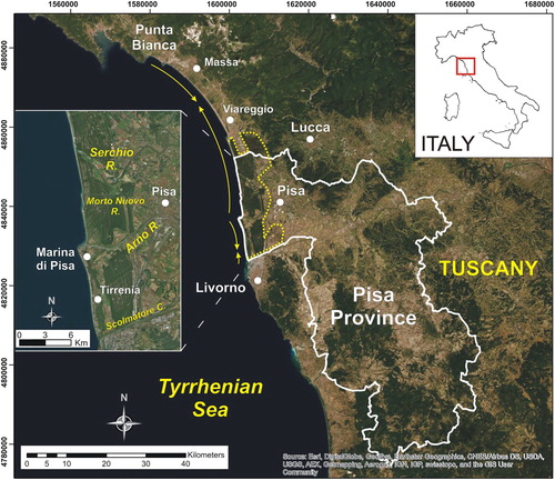
The Pisa Province coastline is about 26 km long and is encompassed within the administrative borders of Lucca to the north and Livorno to the south (). This stretch of coast is located in the northern sector of Tuscany (western Italy) and belongs to the Northern Tuscany littoral cell, which extends for about 64 km from the Punta Bianca promontory to the north and the Port of Livorno to the south (CitationAnfuso, Pranzini, & Vitale, 2011). The Pisa coastal plain is a strandplain that has evolved over the last 3000 years by the Arno and Serchio rivers (CitationRossi, Amorosi, Sarti, & Potenza, 2011) and overlies the Viareggio extensional basin, which is a half-graben that has been active since the late Miocene (CitationPascucci, 2005). Stratigraphic data concerning the alternations of terrestrial and marine deposits related to glacial-interglacial cycles reveal that the Pisa coastal plain is constituted by multiple transgressive-regressive sequences (CitationAmorosi et al., 2013). Currently, the major morphological feature is represented by the Arno River mouth, which is located midway through the Pisa coastline and separates two littoral subcells characterized by divergent drift directions (). The southernmost sector is characterized by a northward-trending drift (CitationCappietti et al., 2003). Three other streams flow into the sea along the Pisa shoreline (namely Serchio River, Morto Nuovo River, and Scolmatore channel), but they are subordinate to the Arno River's catchment area and its high annual sediment load (CitationCavazza, 1984). The recent evolution of the Arno River delta is strongly related to increasing human pressure reported in the area during the last millennium (CitationKaniewski et al., 2018). Progradation of the delta was recorded since 1606, as soon as the mouth was artificially offset to the west to avert major floods inland (CitationPranzini, 2001). Towards the end of the nineteenth century, erosion processes began to affect the area, causing coastline retreat in the whole area of the delta. The effects of erosion over time led to safety issues at a seaside village (Marina di Pisa). This erosion made it necessary to develop a long series of protective structures (e.g. groynes, breakwaters, seawalls) on the left side of the delta. The structures were put in place to protect the buildings, and in the end stabilizing the coastline at its present configuration. Conversely, the right side was not protected as it was a natural reserve area now belonging to the Migliarino – San Rossore – Massaciuccoli Regional Park (CitationPranzini, 2001). The left side has been recently redeveloped with the construction of artificial gravel beaches, which helped increase tourism revenues (CitationNordstrom, Pranzini, Jackson, & Coli, 2008). Significant mass loss on the refill material was reported in later years (CitationBertoni et al., 2016; CitationBertoni, Sarti, Benelli, & Pozzebon, 2012). The area north of the mouth has been subjected to significant erosion rates during the last century (CitationBini, Casarosa, & Ribolini, 2008); coastline retreat has not slowed down in recent years, leading to the erosion of large sectors of the dune field that characterizes this stretch of coast (CitationAlquini, Bertoni, & Sarti, 2016). Wave state in this sector of the Tyrrhenian Sea is prevalently characterized by WSW waves, even though the strongest high-energy events come from the southwest (CitationCipriani, Ferri, Iannotta, Paolieri, & Pranzini, 2001). The tidal regime can be classified as microtidal, as the tidal range is hardly over 30 cm.
Figure 1. Location map of the study area. The yellow lines represent the direction of the littoral drifts along the Northern Tuscany littoral cell. The yellow dotted line outlines the area belonging to the Migliarino – San Rossore – Massaciuccoli Regional Park.
3. Materials and methods
The maps enclose a lot of data acquired through a multidisciplinary approach over an area of about 200 km2. The remote sensing data (Digital Terrain Model, DTM) have been compared with ground-truth observations and combined with accurate on-field surveys, sediment sampling, laboratory analysis, and morphological classification of dunes. The chronological framework was derived by bibliographic sources.
3.1. Remote sensing data
The availability of free-of-charge LiDAR (Light Detection and Ranging) data from GEOscopio website (Tuscany Region geo-portal) allowed the employment of a detailed Digital Terrain Model (DTM) of the study area as source data for map construction/realization. The LASER (Light Amplification by the Stimulated Emission of Radiation) scanner acquisition enables the production of Digital Elevation Model (DEM) even of the ‘bare’ ground surface (DTM), in which any other feature lying on the terrain (e.g. trees, building, etc.) has been removed. The use of DTM rather than DEM is essential for morphologic investigation, especially in densely vegetated areas as in the case of the Arno River delta. LiDAR data (i.e. x,y,z points cloud) that produced the DEM used in this work have been acquired with a LASER airborne survey between 2008 and 2009 by MATTM (Ministero dell’Ambiente e della Tutela del Territorio e del Mare). DEMs provided from MATTM display 1 × 1 m or 2 × 2 m ground resolutions and planimetric and altimetric accuracy of ±30 cm and ±15 cm, respectively. Enhancement techniques were applied within GIS environment to the LiDAR DTM raster visualization in order to obtain a basemap characterized by an increased 3D effect. Such rendering helps appreciate the low topographic features within the study area.
3.2. Field data
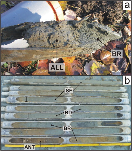
The detailed geological survey was carried out as a field check of the geomorphological features the preliminary aerial image photo-interpretation revealed. The survey was made using a topographic base map (1:5000 scale) of the study area, which includes the shoreline and the oldest dune ridges or the alluvial plain deposits. The units were discerned based on morphological and sedimentological features, such as the presence of landforms and deposits related to aeolian deposition, the morphometry of frontal dunes, the identification of paleosols, and the presence of relict alluvial forms. The discrimination between units in the inner sectors was made based on samples collected by means of a hand auger to reach the undisturbed layer of sediments (about 30–70 cm deep). Samples were taken from the surface elsewhere. Additional hand auger and vibracore drills were carried out at significant sites to better identify the depositional facies in the area between the Arno River and the Scolmatore channel (). Grain-size analysis was carried out on about 230 samples collected along 5 cross-shore transects, starting from the foreshore to the oldest dune ridge (CitationBertoni & Sarti, 2011). Sediments were dry-sieved in laboratory, and the resulting data were processed to calculate CitationFolk and Ward (1957) parameters such as sediment mean grain-size and sorting.
Figure 2. Pictures of some sediment samples collected from the deposits that have been recognized during the geological survey of the study area. (a) Hand auger sampling: sediment sample taken close to the mouth of the Morto Nuovo River showing the transition between beach ridge deposits (BR) and the overlying alluvial deposits (ALL); (b) vibracore sampling: series of cores representing the stratigraphy of the study area at the vibracore drilling location (black dot, Map 1) – ANT: anthropogenic area; BR: beach ridge deposits; BD: beach deposits; SF: shoreface deposits.
3.3. Chronological framework
The chronological setting of the study area and of the main geomorphological features is derived by an accurate review of the existing bibliographic sources related to archeological findings. The dates of the dune ridges are in accordance with those reported by CitationMazzanti and Pasquinucci (1983), CitationDella Rocca, Mazzanti, and Pranzini (1987), CitationCarratori et al. (1994), and CitationGattiglia (2013). The oldest dune ridge dates back to between the 8th century and the 1st century BC, while subsequent dune ridges are more accurately dated and are spaced just a few centuries in between (CitationDella Rocca et al., 1987; CitationPranzini, 2001).
4. Results
All collected data were included in the maps concerning litho-sedimentological and morphodynamic features of the selected site. The following paragraphs illustrate the most important findings for each aspect.
4.1. Litho-sedimentological map (Main Map 1)
The litho-sedimentological map of the study area concerns the sedimentological characterization of the deposits. The sediments have deposited during the Upper Pleistocene – Holocene in marine and alluvial environments. The results of grain-size analysis carried out on the samples collected along the cross-shore transects are shown through diagrams (bottom right panel, Map 1). The topography of the transects is also shown in order to define the main morphological features of the study site (top right panel, Map 1). The topographic profiles have been extracted from the LiDAR DTM. Specifically, the following units have been mapped:
-
Anthropogenic areas. This unit includes areas where the geologic and geomorphological features are strongly modified by human activities. They are almost exclusively present south of the Arno River, as the study area belongs to the Migliarino – San Rossore – Massaciuccoli Regional Park northwards.
-
Coastal marine and transitional deposits. These represent the juxtaposition of subsequent new beach ridges, running parallel to present-day coastline, and present beach forming a wide sandy strandplain area (Holocene). The following depositional facies can be recognized within the coastal marine deposits:
-
o Beach deposits. They are constituted by well-sorted medium to coarse sands. The grain-size decreases in the backshore where sands are widely subject to aeolian selective processes.
-
o Beach ridge deposits. Although they are formed by a complex set of morphologies, sediment grain-size analysis does not evidence substantial changes (bottom right panel, Map 1). All the samples fall in a medium to fine sand grain-size range and show poor sorting. In contrast with previous works (e.g. CitationCarratori et al., 1994; CitationDella Rocca et al., 1987), hand-auger boreholes do not show grain-size changes in the swale area (known as ‘lame’) comprised between two consecutive beach ridges. Within this overall setting, systematic analysis of data collected along transects roughly perpendicular to the beach ridge alignments shows a faint westward grain-size increase, i.e. from oldest to youngest beach-ridges (CitationBertoni & Sarti, 2011). Mean (Mz) values are comprised between 355 μm and 120 μm, with a sharp variation at the transition from secondary (stabilized) and primary (active) dunes. This abrupt change has been related to a variation of Arno River sediment supply occurred after the seventeenth century mouth cutoff (CitationBertoni & Sarti, 2011).
-
o Back-barrier deposits. These outcrop in the southern portion of the study area and were deposited in a suite of depositional environments mainly composed by small, ephemeral bays and lagoons. Lithologies are constituted by an alternation of well-sorted fine to medium sands and silty sands occasionally containing organic-rich layers.
-
o Paludal deposits. Darkish organic-rich clay and silty clay. They form in small, hyperaline, ephemeral wet areas close to the coastline just north of the Arno River delta in the swales between sandy ridges (Holocene).
-
-
Terrestrial deposits:
-
o Alluvial plain and/or reclaimed areas. The present-day alluvial plain is constituted by light brown silt, silty sand and clay. Their deposition is due to fluvial processes such as recurrent floods and channel avulsion related to Arno River evolution (CitationMartini, Sarti, Pallecchi, & Costantini, 2011; CitationPranzini, 2001). Some reclaimed areas filled with alluvial deposits since the last five centuries are also included in this unit (CitationSarti, Bini, & Giacomelli, 2010). Alluvial deposits also outcrop in the swales close to the Arno River. As swales are elongate depressions encompassed within two consecutive beach ridges, they are morphological traps able to accommodate sediments during floods (Holocene).
-
o Alluvial deposits. Yellow silty-sandy deposits. These outcrop in a small area backing the oldest beach ridge, belonging to the Upper Pleistocene ‘Coltano formation’ (CitationCarratori et al., 1994; CitationSarti, Rossi, & Giacomelli, 2015).
-
4.2. Morphodynamic map (Main Map 2)
The following sets of data are integrated in the morphodynamic map:
-
Beach-ridge alignments, dated beach-ridges, and beach-ridge elevation range derived from LiDAR Digital Terrain Models (DTM). The range is subdivided in three ridge elevation classes: <2 m, between 2 and 3 m, and >3 m.
-
The positions of archeological proxies relevant to fix chronological constraints.
-
Main hydraulic waterworks along the Arno River.
-
Longshore drift direction.
-
Eroding and accreting sectors along the coastline.
-
A polar graph displaying wave frequency of occurrence and direction.
The wide strandplain shown in the map formed as a consequence of sediment supply delivered by the Arno and Serchio rivers. These deltas can be defined as wave-dominated in accordance with CitationGalloway (1975). The sand delivered to the sea is distributed along the coast by longshore drift to form an extensive beach ridge strandplain. When sediment supply exceeds accommodation space a progradational depositional trend is triggered. The coastline shifts seawards (CitationCatuneanu, 2006), resulting in the formation of a beach ridge strandplain complex. In the study area this sandy complex constitutes the outcropping depositional portion of the late Holocene progradational system forming after mid Holocene sea-level stabilization (CitationKaniewski et al., 2018). Since about 3000 BP, subsurface (CitationAguzzi et al., 2007; CitationAmorosi et al., 2013) and surface (CitationCarratori et al., 1994) data show the acceleration of coastline seaward migration due to increased sediment supply related to widespread deforestation inland (CitationKaniewski et al., 2018; CitationPranzini, 2001) as well as the reduction in the rate of accommodation space creation. This increase seems to occur at the same time in the whole Mediterranean area (CitationAmorosi & Milli, 2001; CitationAnthony, Marriner, & Morhange, 2014). The overall geometry of the beach ridge strandplain complex is roughly arcuate towards the Arno River mouth and extends from east to west for about 6 km. The age of the innermost beach ridge, defines the timespan in which coastline migration began (CitationCarratori et al., 1994; CitationPranzini, 2001). A sharp geometric discontinuity is observed close to the Arno delta area where, after the seventeenth century AD, the beach ridge became cuspate (CitationPranzini, 2007). This change is related to waterworks carried out to enhance the navigability of the river (cutting off meander loops) and to solve problems such as mouth silting and upstream flooding (CitationMartini et al., 2011; CitationPranzini, 2001). Beach ridge elevation is mainly between 2 and 3 m asl. The elevation of beach ridges is related to sediment supply and, as a consequence, to the rate of coastline progradation (CitationOtvos, 2000, Citation2012; CitationTamura, 2012). High rates of coastline progradation seem to promote the development of low and closely-spaced beach ridges, while low progradation rates seem to be associated with higher and wider spaced beach ridges.
As the Pisa Province coastline is characterized by the presence of different types of coastal dunes, they have been recognized and classified as follows. In accordance with the classification scheme of CitationMasselink and Hughes (2003), from the backshore to the innermost beach ridge alignments we recognized: (i) an area close to the shoreline where accretion/erosion effects are documented due to aeolian processes and storm wave-driven events, and (ii) a vegetated area which is subjected to weak wind-driven dune modification. Primary and secondary dunes (sensu CitationDavies, 1980) characterize the two areas respectively. Primary dunes consist of incipient foredunes and frontal or parabolic dunes. Incipient foredunes, which form just on accretional or in equilibrium beaches (CitationHesp, 2002), occur in a small stretch of coast south of the Serchio River that is not yet subjected to erosion. These foredunes form a continuous asymmetric ridge, running for about 1700 m (Zoom 1, Map 2) parallel to the coastline.
During accretion states, frontal dunes represent the natural evolution of the incipient foredunes in terms of growth. South of the Serchio River they develop for about 5 km and may reach up to 10 m in height (Zoom 1 and 2, Map 2). Frontal dunes are occasionally interrupted by blowouts that can trigger the formation of parabolic dunes (Zoom 1 and 2, Map 2). Landward the beach ridges are secondary dunes (Zoom 3, Map 2). They are characterized by areas where the vegetation is mostly shrubs and semi-mobile dunes are formed between areas where the dense arboreous vegetation inhibits wind processes (steady dunes). The primary dunes have progressively turned into secondary dunes. In between these two areas, and relatively close to the coastline, erosion leads to reworking of the secondary dunes. The most significant effects are manifest in the sectors where erosion is higher, such as the area within the north side of the Arno River and the Morto River (CitationAlquini et al., 2016), located in the Migliarino – San Rossore – Massaciuccoli Regional Park. Here, the partial or complete erosion of frontal dunes results in the burial of backing secondary dunes, triggering the progressive destruction of the vegetation. This area, still subject to intensive erosion, runs parallel to the coast and reaches a maximum width of about 300 m. Two areas are slightly below sea level: the first is located just north of the Arno River and is characterized by ephemeral small marshes (Zoom 4, Map 2); the second is located in the southern part of the study area and was occupied by small lagoons during the last centuries (Zoom 5, Map 2). The sector south of the Arno River mouth is characterized by dense human occupation. Two settlements, Marina di Pisa and Tirrenia, were raised in the late nineteenth century and quickly became important drivers for the tourism economy; however, they had to be protected with several hard structures (breakwaters, groynes, seawalls) once erosion reduced the sandy beach and threatened the buildings (Zoom 5, Map 2).
5. Conclusions
The maps presented here are based on solid and deep databases that can be constantly improved and integrated as new data are acquired. Litho-sedimentological and morphodynamic features are just two of the several aspects that might be shown on such maps; in fact, they can also be complemented with or dedicated to data from different themes, such as biology (e.g. fauna and flora issues) and environmental science (e.g. pollution level), and also economy (e.g. land use and value). In this sense, they may constitute the basic data that can be used for more specific research, while encouraging a multidisciplinary approach. Merging newly acquired lithological and sedimentological data retrieved by the literature allowed us to identify changes on this sector of the Tuscany coast in the last 3000 years. Such data were matched with an original rendering of available remote sensing data to highlight the topographic features, which is especially useful in an area characterized by small elevations. The integration of new data should be managed by public administrations, which are the supply agencies responsible for handling the territory. The synergy among researchers, administrations, stakeholders and citizens should establish the best practices for coastal management. Unfortunately, at least in Italy, this synergy often represents the weak link that needs improvement. The maps we provide are a digested synthesis of many aspects, which are presented in a way that is more easily comprehensible to different stakeholders, especially with regard to the relationships between data related to different themes (e.g. geological vs morphodynamic aspects). Therefore, multi-thematic maps, along with coastal vulnerability indices, may be the tools that can be employed by all the actors playing major roles in managing coastal areas.
Software
Management and processing of LiDAR data have been performed with QGIS (Geographical Information System) software environment. In detail, a mosaicking of the all the LiDAR sheets (1:2000 scale) covering the study area was carried out, producing a single DTM raster extending from the Bufalina channel (north, Province of Lucca) to the Scolmatore channel (south, Province of Livorno), and from the Arno River mouth (west) to the Barbaricina meander (east). A grey-scale hillshade of the DTM along with a classified symbology of the elevation values (meters on ground level) is the background for a detailed digitalization of all the main morphologic features characterizing the study area. The final layout of the maps has been achieved using CorelDRAW Graphics Suite 12 (License no. DR12WEX-1511962-ALE).
Map2_A3_Bertoni_et_alii.pdf
Download PDF (17.2 MB)Map1_A3_Bertoni_et_alii.pdf
Download PDF (24.9 MB)Acknowledgements
The Authors are thankful to Dr Fernanda Alquini, who helped out retrieving literature data. The aerial picture of the protection structures at Marina di Pisa has been kindly provided by prof. Arthur C. Trembanis. The Authors also thank prof. Maria Sgavetti for her generous helpfulness. Insightful observations and comments raised by reviewers Luisa Sabato and Ivan Martini and editor Jasper Knight led to significant improvements to the final version of the manuscript. DB's work was in part financially supported by the grant ‘PRA_2018_41 Georisorse e Ambiente’ awarded to Dr Simona Raneri.
Disclosure statement
No potential conflict of interest was reported by the authors.
Additional information
Funding
Related Research Data
References
- Aguzzi, M. , Amorosi, A. , Colalongo, M. L. , Ricci Lucchi, M. , Rossi, V. , Sarti, G. , & Vaiani, S. C. (2007). Late Quaternary climatic evolution of the Arno coastal plain (Western Tuscany, Italy) from subsurface data. Sedimentary Geology , 202 , 211–229. doi: 10.1016/j.sedgeo.2007.03.004
- Alquini, F. , Bertoni, D. , & Sarti, G. (2016). Extreme erosion of a dune crest within a short timespan (January-September 2016): The recent case in the Migliarino – San Rossore – Massaciuccoli Regional Park (Tuscany, Italy). Atti della Società Toscana di Scienze Naturali, Memorie Serie A , 123 , 5–16. doi: 10.2424/ASTSN.M.2016.15
- Alquini, F. , Bertoni, D. , Sarti, G. , Vieira, C. V. , & Melo Júnior, J. C. F. (2018). Morpho-sedimentological and vegetational characterization of Grande beach at São Francisco do Sul island (Santa Catarina, Brazil). Journal of Maps , 14 , 105–113. doi: 10.1080/17445647.2018.1438317
- Amorosi, A. , Bini, M. , Giacomelli, S. , Pappalardo, M. , Ribecai, C. , Rossi, V. , … Sarti, G. (2013). Middle to late Holocene environmental evolution of the Pisa coastal plain (Tuscany, Italy) and early human settlements. Quaternary International , 303 , 93–106. doi: 10.1016/j.quaint.2013.03.030
- Amorosi, A. , & Milli, S. (2001). Late Quaternary depositional architecture of Po and Tevere river deltas (Italy) and worldwide comparison with coeval deltaic successions. Sedimentary Geology , 144 (3–4), 357–375. doi: 10.1016/S0037-0738(01)00129-4
- Anfuso, G. , Pranzini, E. , & Vitale, G. (2011). An integrated approach to coastal erosion problems in northern Tuscany (Italy): Littoral morphological evolution and cell distribution. Geomorphology , 129 , 204–214. doi: 10.1016/j.geomorph.2011.01.023
- Anthony, E. J. , Marriner, N. , & Morhange, C. (2014). Human influence and the changing geomorphology of Mediterranean deltas and coasts over the last 6000 years: From progradation to destruction phase? Earth-Science Reviews , 139 , 336–361. doi: 10.1016/j.earscirev.2014.10.003
- Bartolini, S. , Mecocci, A. , Pozzebon, A. , Zoppetti, C. , Bertoni, D. , Sarti, G. , … Moretti, S. (2018). Augmented virtuality for coastal management: A holistic use of in situ and remote sensing for large scale definition of coastal dynamics. ISPRS International Journal of Geo-Information , 7 , 92. doi: 10.3390/ijgi7030092
- Bertoni, D. , & Sarti, G. (2011). Grain size characterization of modern and ancient dunes within a dune field along the Pisan coast (Tuscany, Italy). Atti Società Toscana Scienze Naturali, Memorie Serie A , 116 , 11–16. doi: 10.2424/ASTSN.M.2011.02
- Bertoni, D. , Sarti, G. , Benelli, G. , & Pozzebon, A. (2012). In situ abrasion of marked pebbles on two coarse-clastic beaches (Marina di Pisa, Italy). Italian Journal of Geosciences , 131 (2), 205–214. doi: 10.3301/IJG.2012.04
- Bertoni, D. , Sarti, G. , Grottoli, E. , Ciavola, P. , Pozzebon, A. , Domokos, G. , & Novák-Szabó, T. (2016). Impressive abrasion rates of marked pebbles on a coarse-clastic beach within a 13-month timespan. Marine Geology , 381 , 175–180. doi: 10.1016/j.margeo.2016.09.010
- Bini, M. , Casarosa, N. , & Ribolini, A. (2008). Multitemporal (1938–2004) evolution of the Pisan shoreline based on the comparison of georeferenced aerial images. Atti della Società Toscana di Scienze Naturali, Memorie Serie A , 113 , 1–12.
- Cappietti, L. , Cammelli, C. , Farrell, E. , Ferri, S. , Aminti, P. L. , & Pranzini, E. (2003). A case of updrift erosion induced by a harbour breakwater . Ravenna : Medcoast 2003. pp. 1701–1718.
- Carratori, L. , Ceccarelli Lemut, M. L. , Frattarelli Fischer, L. , Garzella, G. , Greco, G. , Grifoni Cremonesi, R. , … Tozzi, C. (1994). Carta degli elementi naturalistici e storici della Pianura di Pisa e dei rilievi contermini, scala 1:50.000. In R. Mazzanti (Ed.), La pianura di Pisa e i rilievi contermini la natura e la storia: Memorie Società Geografica Italiana (pp. 491). Roma: Edizioni Del Cerro.
- Catuneanu, O. (2006). Principles of sequence stratigraphy . Amsterdam : Elsevier.
- Cavazza, S. (1984). Regionalizzazione geomorfologica del trasporto solido in sospensione dei corsi d'acqua tra il Magra e l'Ombrone. Atti della Società Toscana di Scienze Naturali, Memorie Serie A , 91 , 119–132.
- Ciccarelli, D. , Pinna, M. S. , Alquini, F. , Cogoni, D. , Ruocco, M. , Bacchetta, G. , … Fenu, G. (2017). Development of a coastal dune vulnerability index for Mediterranean ecosystems: A useful tool for coastal managers? Estuarine, Coastal and Shelf Science , 187 , 84–95. doi: 10.1016/j.ecss.2016.12.008
- Cipriani, L. E. , Ferri, S. , Iannotta, P. , Paolieri, F. , & Pranzini, E. (2001). Morfologia e dinamica dei sedimenti del litorale della Toscana settentrionale. Studi Costieri , 4 , 119–156.
- Davies, J. L. (1980). Geographical variation in coastal development . New York : Longman. p. 212.
- De Muro, S. , Pusceddu, N. , Buosi, C. , & Ibba, A. (2017). Morphodynamics of a Mediterranean microtidal wave-dominated beach: Forms, processes and insights for coastal management. Journal of Maps , 13 , 26–36. doi: 10.1080/17445647.2016.1250681
- Della Rocca, B. , Mazzanti, R. , & Pranzini, E. (1987). Studio geomorfologico della pianura di Pisa. Geografia Fisica e Dinamica Quaternaria , 10 , 56–84.
- Ferrario, F. , Beck, M. W. , Storlazzi, C. D. , Micheli, F. , Shepard, C. C. , & Airoldi, L. (2014). The effectiveness of coral reefs for coastal hazard risk reduction and adaptation. Nature Communications , 5 , 4794. doi: 10.1038/ncomms4794
- Folk, R. L. , & Ward, W. C. (1957). Brazos River bar: A study in the significance of grain size parameters. Journal of Sedimentary Petrology , 27 , 3–26. doi: 10.1306/74D70646-2B21-11D7-8648000102C1865D
- Galloway, W. E. (1975). Process framework for describing the morphologic and stratigraphic evolution of deltaic depositional systems. In M. L. Broussard (Ed.), Deltas: Models for exploration (pp. 87–98). Houston, TX: Houston Geological Society.
- García-Mora, M. R. , Gallego-Fernández, J. B. , Williams, A. T. , & García-Novo, F. (2001). A coastal Dune Vulnerability classification. A case study of the SW Iberian Peninsula. Journal of Coastal Research , 17 , 802–811.
- Gattiglia, G. (2013). MAPPA. Pisa medievale: archeologia, analisi spaziali e modelli predittivi . Roma : Edizioni Nuova Cultura, p. 218.
- Gornitz, V. (1991). Global coastal hazards from future sea level rise. Palaeogeography Palaeoclimatology Palaeoecology , 89 , 379–398. doi:10.1016/0921-8181(91)90118-G doi: 10.1016/0031-0182(91)90173-O
- Gornitz, V. , & Kanciruk, P. (1989). Assessment of global coastal hazards from sea level rise. In Proceedings of the 6th symposium on coastal and Ocean management (pp. 1345–1359). Charleston, USA .
- Gornitz, V. M. , Daniels, R. C. , White, T. W. , & Birdwell, K. R. (1994). The development of a coastal risk assessment database: Vulnerability to sea-level rise in the U.S. southeast. Journal of Coastal Research , SI12 , 327–338.
- Hesp, P. (2002). Foredunes and blowouts: Initiation, geomorphology and dynamics. Geomorphology , 48 , 245–268. doi: 10.1016/S0169-555X(02)00184-8
- Hinkel, J. , Jaeger, C. , Nicholls, R. J. , Lowe, J. , Renn, O. , & Peijun, S. (2015). Sea-level rise scenarios and coastal risk management. Nature Climate Change , 5 , 188–190. doi: 10.1038/nclimate2505
- Jabaloy-Sánchez, A. , Lobo, F. J. , Azor, A. , Bárcenas, P. , Fernández-Salas, L. M. , Díaz del Río, V. , & Pérez-Peña, J. V. (2010). Human-driven coastline changes in the Adra River deltaic system, southeast Spain. Geomorphology , 119 , 9–22. doi: 10.1016/j.geomorph.2010.02.004
- Kaniewski, D. , Marriner, N. , Morhange, C. , Vacchi, M. , Sarti, G. , Rossi, V. , … Van Campo, E. (2018). Holocene evolution of Portus Pisanus, the lost harbour of Pisa. Scientific Reports , 8 , 11625. doi: 10.1038/s41598-018-29890-w
- Laïbi, R. A. , Anthony, E. J. , Almar, N. , Castelle, B. , Senechal, N. , & Kestenare, E. (2014). Longshore drift cell development on the human-impacted Bight of Benin sand barrier coast, West Africa. Journal of Coastal Research , SI70 , 78–83. doi: 10.2112/SI70-014.1
- Li, W. , & Gong, P. (2016). Continuous monitoring of coastline dynamics in western Florida with a 30-year time series of Landsat imagery. Remote Sensing of Environment , 179 , 196–209. doi: 10.1016/j.rse.2016.03.031
- Martínez, M. L. , Gallego-Fernández, J. B. , García-Franco, J. G. , Moctezuma, C. , & Jiménez, C. D. (2006). Assessment of coastal dune vulnerability to natural and anthropogenic disturbances along the Gulf of Mexico. Environmental Conservation , 33 , 109–117. doi: 10.1017/S0376892906002876
- Martini, I. P. , Sarti, G. , Pallecchi, P. , & Costantini, A. (2011). Landscape influences on the development of the medieval-early Renaissance City-states of Pisa, Florence, and Siena, Italy. In Landscapes and Societies: Selected Cases (pp. 203–221).: Springer. doi: 10.1007/978-90-481-9413-1_13
- Masselink, G. , & Hughes, M. G. (2003). Introduction to coastal processes & geomorphology . London, UK : Arnold, p. 354.
- Mazzanti, R. , & Pasquinucci, M. (1983). L’evoluzione del litorale Lunense-Pisano alla metà del XIX secolo. Bollettino della Società Geografica Italiana , 12 , 605–628.
- Meyer-Arendt, K. J. (2001). Recreational development and shoreline modification along the north coast of Yucatán, Mexico. Tourism Geographies , 3 , 87–104. doi: 10.1080/14616680010008720
- Nordstrom, K. F. , Pranzini, E. , Jackson, N. L. , & Coli, M. (2008). The marble beaches of Tuscany. Geographical Review , 98 , 280–300. doi: 10.1111/j.1931-0846.2008.tb00300.x
- Otvos, E. G. (2000). Beach ridges – Definitions and significance. Geomorphology , 32 (1–2), 83–108. doi: 10.1016/S0169-555X(99)00075-6
- Otvos, E. G. (2012). Coastal barriers – Nomenclature, processes, and classification issues. Geomorphology , 139–140 , 39–52. doi: 10.1016/j.geomorph.2011.10.037
- Pascucci, V. (2005). Neogene evolution of the Viareggio basin, northern Tuscany (Italy). GeoActa , 4 , 123–138.
- Poelhekke, L. , Jäger, W. S. , van Dongeren, A. , Plomaritis, T. A. , McCall, R. , & Ferreira, Ó . (2016). Predicting coastal hazards for sandy coasts with a Bayesian Network. Coastal Engineering , 118 , 21–34. doi: 10.1016/j.coastaleng.2016.08.011
- Pranzini, E. (2001). Updrift river mouth migration on cuspate deltas: Two examples from the coast of Tuscany (Italy). Geomorphology , 38 , 125–132. doi: 10.1016/S0169-555X(00)00076-3
- Pranzini, E. (2007). Airborne LIDAR survey applied to the analysis of the historical evolution of the Arno River delta (Italy). Journal of Coastal Research , SI50 , 400–409.
- Rossi, V. , Amorosi, A. , Sarti, G. , & Potenza, M. (2011). Influence of inherited topography on the Holocene sedimentary evolution of coastal systems: An example from Arno coastal plain (Tuscany, Italy). Geomorphology , 135 (1–2), 117–128. doi: 10.1016/j.geomorph.2011.08.009
- Sabato, L. , Longhitano, S. G. , Gioia, D. , Cilumbriello, A. , & Spalluto, L. (2012). Sedimentological and morpho-evolution maps of the ‘Bosco Pantano di Policoro’ coastal system (Gulf of Taranto, southern Italy). Journal of Maps , 8 , 304–311. doi: 10.1080/17445647.2012.722791
- Sarti, G. , Bini, M. , & Giacomelli, S. (2010). The growth and decline of Pisa (Tuscany, Italy) up to the Middle Ages: Correlations with landscape and geology. Alpine and Mediterranean Quaternary , 23 (2), 311–322.
- Sarti, G. , Rossi, V. , & Giacomelli, S. (2015). The upper pleistocene ‘isola di coltano sands’ (arno coastal plain, tuscany Italy): Review of stratigraphic data and tectonic implications for the southern margin of the viareggio basin. Atti della Società Toscana di Scienze Naturali, Memorie Serie A , 122 , 75–84. doi: 10.2424/ASTSN.M.2015.22
- Stive, M. J. , Aarninkhof, S. G. , Hamm, L. , Hanson, H. , Larson, M. , Wijnberg, K. M. , … Capobianco, M. (2002). Variability of shore and shoreline evolution. Coastal Engineering , 47 , 211–235. doi: 10.1016/S0378-3839(02)00126-6
- Tamura, T. (2012). Beach ridges and prograded beach deposits as palaeoenvironment records. Earth-Science Reviews , 114 (3–4), 279–297. doi: 10.1016/j.earscirev.2012.06.004
- van Dongeren, A. , Ciavola, P. , Martinez, G. , Viavattene, C. , Bogaard, T. , Ferreira, Ó , … McCall, R. (2018). Introduction to RISC-KIT: Resilience-increasing strategies for coasts. Coastal Engineering , 134 , 2–9. doi: 10.1016/j.coastaleng.2017.10.007
- Ying, X. , Ding, P. , Wang, Z. B. , & Van Maren, D. S. (2011). Morphological impact of the construction of an offshore Yangshan Deepwater Harbor in the Port of Shanghai, China. Journal of Coastal Research , 28 , 163–173. doi: 10.2112/JCOASTRES-D-11-00046.1