
ABSTRACT
A volcanological map of the active Somma-Vesuvius volcano is presented at the 1:20,000 scale. The map is based on 1:5000 field mapping carried out during the Italian CARG project. Geological data are represented on a digital terrain model of the volcano. This allows a better visualisation of the main morphological, volcanic, and geological features. The legend is organised in four different panels, which depict the activity of the volcano and caldera development. The geological survey is based on recognition and description of lithostratigraphic units. The geological map highlights the volcanic evolution of the Somma-Vesuvius volcano, and it is propaedeutic for further studies aimed at improving the scientific knowledge and the volcanic hazard assessment of this world-famous volcano.
1. Introduction
The Somma-Vesuvius, together with the Phlegrean Fields Volcanic District (CitationRosi & Sbrana, 1987; CitationSbrana, Marianelli, & Pasquini, 2018 and references therein), are part of a series of active volcanic complexes developed within the extensional graben of the Campanian plain, one of the most important peri-Tyrrhenian structures of the Southern Apennines chain. Its formation occurred from Miocene to Pleistocene following the opening of the Tyrrhenian basin (CitationPeccerillo, 2005).
Somma-Vesuvius volcano formed at the intersection of two main, NE-SW and NW-SE fault systems, inside the southeast portion of the Campanian plain half graben. In this side of the graben, the Mesozoic carbonate units represent the basement of the volcano (below 1800 m of depth) and host part of the magma feeding system. In some cases, the presence of carbonates influences the eruption dynamics, through the interaction between magma and carbonate-derived CO2, and possibly the magma composition by carbonate assimilation (CitationDallai, Cioni, Boschi, & D’Oriano, 2011; CitationIacono Marziano, Gaillard, & Pichavant, 2008; CitationPeccerillo, 2005; CitationRittmann, 1933; CitationSavelli, 1967), and distinguishes Somma-Vesuvius from the volcanoes of the Phlegrean Fields Volcanic District (carbonate basement deeper than 4000 m).
Despite Somma-Vesuvius is worldwide recognised as one of the most hazardous volcanoes, few geological maps have been published. After the pioneering geological map of sir CitationJohnston-Lavis (1891), a geological map of Somma-Vesuvius Volcanic Complex at 1:25,000 scale was published by CitationRosi, Santacroce, and Sbrana (1986), containing a detailed survey of both ancient and modern lava flows, the latter performed through the analysis of historical documents combined with field data. However, the geological map did not describe the complex pyroclastic successions, that were mapped through the use of a single unit. In the framework of the CARG’88 project, financed by Servizio Geologico d’Italia (ISPRA) and aimed at obtaining a new 1:50,000 geological map of Italy, new geological surveys and volcanological studies started in the Somma-Vesuvius area in the 90s. They produced a more detailed and accurate geological map of Somma-Vesuvius and the surrounding plain at 1:15,000 scale (CitationRegione Campania, 2003). In the same project, other geological maps based on the Unconformity Bounded Stratigraphic Units (UBSU) were implemented, i.e. the 1:50,000 scale Sheets Ercolano and Sorrento (CitationServizio Geologico d’Italia, in press). More recently, a geological map of a limited area in the southwestern sector of the volcano, dominated by the products of the most recent period of activity of the volcano, was published by CitationPaolillo et al. (2016).
Based on the detailed field surveys carried out during the above mentioned CARG’88 project and on new stratigraphic and volcanological studies, an updated geological map of the Somma-Vesuvius volcano is here presented at the scale 1:20,000 (Plate I). Geological data were placed on a digital terrain model (DTM) of the volcano, allowing a better visualisation of the morphological and volcanological features. The legend, based on lithostratigraphic units, was also revised and grouped to better illustrate the volcanological evolution of Somma-Vesuvius. Finally, a large set of published and unpublished volcanological data on dispersal of pyroclastic density currents (PDCs) and fallout deposits of more than 20 explosive events of variable magnitude and intensity was also completely revised and summarised in a dedicated plate (Plate I).
2. Eruptive history of Somma-Vesuvius
The Somma-Vesuvius volcanic complex is formed by an older stratovolcano (Mt. Somma) cut by an eccentric, polyphasic caldera, and by a stratocone (Vesuvius) grown during historical times inside the caldera (). Mt. Somma stands over a large sedimentary plain, prevalently formed by volcaniclastic deposits originated by the mobilisation of the pyroclastic deposits during inter- and syn-eruptive periods, and collectively described as the volcano sedimentary apron of Somma-Vesuvius (CitationRegione Campania, 2003). The volcanoclastic deposits alternate with medial to distal PDCs and fall deposits.
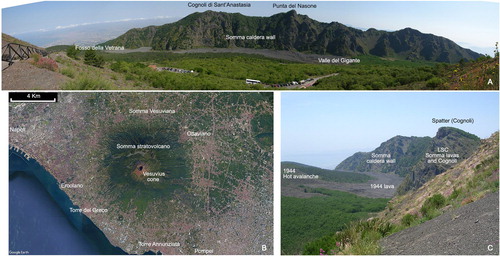
Figure 1. (A): View from Vesuvius cone; in the background the Somma inner caldera wall; in the foreground 1944 lava flow. (B): Somma-Vesuvius (Google Earth image). (C): Valle del Gigante, view from Mt. Somma, Cognoli di Levante. In the foreground Somma spatter cone (Cognoli) and lavas (LSC formation in the main map), and in the background, 1944 lava (lv20 in the main map, centre of picture) and 1944 hot avalanche deposits (1944 va in the main map) overlying the lava flow and Colle Umberto exogenous lava dome (left).
The first detailed stratigraphy of the Somma-Vesuvius was made by CitationDelibrias, Di Paola, Rosi, and Santacroce (1979), who named all the main eruption units and first provided a general chronologic framework. This reconstruction was the base for the monographic work of CitationSantacroce (1987) and was then progressively improved and detailed () by several authors (as summarised in CitationCioni, Bertagnini, Santacroce, & Andronico, 2008 and CitationSantacroce et al., 2008). Nowadays the deposits of a large number of eruptions of different intensity occurred in the last 22 ky of activity are well known in terms of stratigraphy, dispersal and main physical parameters, and many of them can be mapped with a certain detail. Most of the studies dedicated to the different eruptions derive from the detailed stratigraphic work carried out during the field survey for the new geological map, and isopach maps of more than 20 events have been revised and presented in the synoptic Plate I.
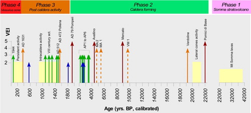
Figure 2. Simplified chronostratigraphic sequence (not to scale) of Somma-Vesuvius. Arrows refer to explosive eruptions, length and colour (blue = VEI 2; green = VEI 3; orange = VEI 4; red = VEI 5) reflect the estimated VEI (data from CitationCioni et al., 2008); dashed arrows mark eruptions of uncertain source. Yellow boxes show periods of persistent strombolian and effusive activity.
The construction of the stratovolcano started after the Campanian Ignimbrite eruption (Phlegrean Fields; 39 ky, CitationDe Vivo et al., 2001), as evidenced by the stratigraphy of the Trecase 1 geothermal well (CitationBrocchini, Principe, Castradori, Laurenzi, & Gorla, 2001). The stratovolcano grew up to around 2000 m in height over a time span of ca. 20 ky (CitationCioni, Santacroce, & Sbrana, 1999), mainly through the piling up of lava flows and spatter and loose scoria deposits. The main effusive to mildly explosive activity of the Somma stratovolcano was interrupted around 22 ky BP by the trachytic Pomici di Base Plinian eruption (CitationSantacroce et al., 2008). This event marked the onset of the multistage Somma caldera formation (CitationCioni et al., 1999) and the shift to a more explosive activity fed by generally evolved magmas. The Pomici di Base eruption was followed by effusive/mildly explosive activity from lateral vents, aligned along regional faults (San Severino, Pollena and Camaldoli eruptive fracture systems) () and, after about 3 ky, by the Pomici Verdoline ((A)) subplinian eruption (CitationCioni, Sulpizio, & Garruccio, 2003). The following 15 ky period of activity was characterised by two, large intensity (Plinian) eruptions, separated by long periods of nearly complete quiescence, and by a shift from trachytic to phonolitic compositions (). These two Plinian events (Mercato Pumice, 9.0 ky BP; CitationMele, Sulpizio, Dellino, & La Volpe, 2011; Avellino Pumice, 3.9 ky BP; Sevink et al., Citation2011; CitationSulpizio, Bonasia, et al., 2010a, Citation2010b), produced phonolitic and phonolitic to tephriphonolitic products, respectively ((A,B)). Both these Plinian eruptions, culminated in phases of caldera collapse, are related to the partial emptying of a crustal magma reservoir (CitationCioni et al., 1999), which started to define the present-day caldera shape (see the main map and ). No clear activity from Somma-Vesuvius is recorded in the intervening periods separating these two eruptions, except for the sporadic finding of badly preserved, fall deposits dubitatively traceable to the activity of the volcano or from the nearby Phlegrean fields caldera ().
Figure 3. Geological and structural sketch map of Somma-Vesuvius. Submarine gas emission areas from CitationCaliro, Chiodini, Avino, Cardellini, and Frondini (2005).
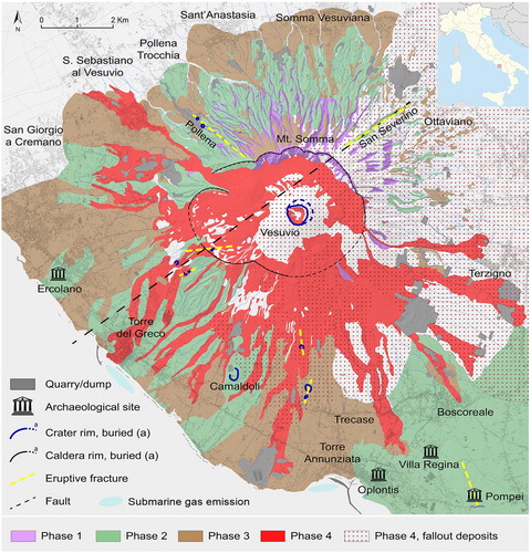
Figure 4. (A) Traianello quarry. The white pumice layer in the middle of the sequence is the base of the Mercato Pumice fallout, followed on top by pyroclastic flow unit. The thinly stratified fallout deposits of Pomici Verdoline and Campi Flegrei Agnano Pomici Principali are visible below the Mercato Pumice. (B) The fallout sequence (white and grey beds) of the Avellino Pumice. (C) Panoramic view of the Post AD 472 sequence in the area of Terzigno. The sequence is formed by the superposition of scoria and ash fallout beds of several eruptions. The light coloured deposits at the base of the sequence record the final pyroclastic density currents and lahars related to the AD 472 Pollena eruption.
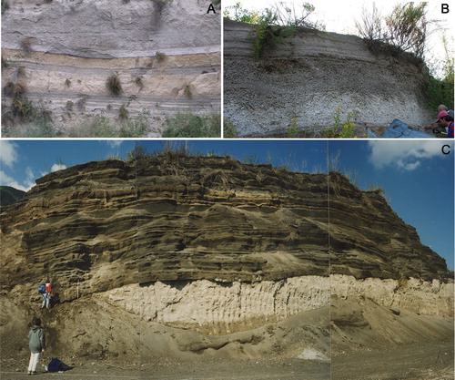
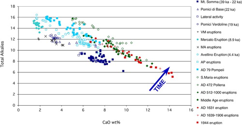
Figure 5. Composition of Somma-Vesuvius products is largely variable through time and within a single eruption. The diagram shows the increasing alkalinity of the erupted products from the Somma lavas up to the most recent products (data from CitationSantacroce et al., 2008).
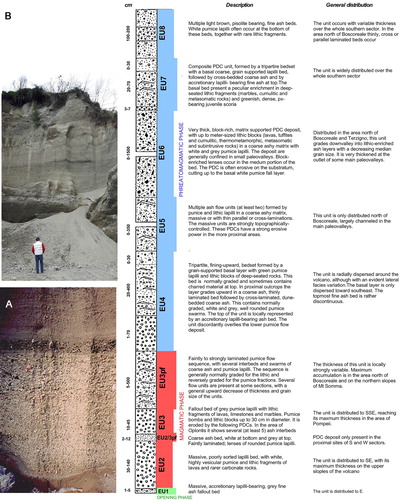
After the Avellino eruption, the frequency of medium to high intensity eruptions increased, with at least 8 explosive events ranging from subplinian to violent strombolian and vulcanian (CitationAndronico & Cioni, 2002). This period of activity ends in 217 BC (CitationStothers & Rampino, 1983) preceding the AD 79 Pompeii Plinian eruption. This iconic event was described in detail by Pliny the Younger, who was the first eyewitness of a large volcanic eruption that handed down a written report of this natural phenomenon. The deposits are represented by a widely dispersed pumice fallout and by numerous PDCs (). Magma composition varies from phonolitic to tephriphonolitic, mainly differing from the preceding products for the highest K2O/Na2O ratio. The deposits of AD 79 eruption are still easily visible in the main archaeological sites of Ercolano, Oplontis and Pompei () and in several other minor excavations. The eruption modified the morphology surroundings the volcano, producing a general increase of the elevations up to 10–20 m in Ercolano (CitationGuidobaldi, Camardo, & Rossi, 2014) and Pompei archeological areas (Vogel, Maerker, & Seiler, Citation2011), and an important variation of the coastline, as reported in the geological map (main map; CitationCinque & Irollo, 2004; CitationGuidobaldi, Camardo, & Notomista, 2014).
Figure 6. A general consensus exists on the stratigraphy of the AD 79 eruption deposits (CitationCioni, Marianelli, & Sbrana, 1992; CitationSigurdsson, Carey, Cornell, & Pescatore, 1985) with the definition of three different phases. The Opening phase, comprising only a few centimetres of accretionary lapilli-bearing ash fall and very minor surge beds, was followed by the Plinian magmatic phase, mostly consisting of tephra fallout (white and grey pumice layers, phonolitic to tephriphonolitic) dispersed in an elongated fan to SSW. This fallout deposit is the product of a sustained Plinian column, which during the deposition of the grey pumice collapsed at least four times producing low concentration, turbulent pyroclastic density currents (hereafter PDCs). The latter can be found interlayered in the fallout deposits along the slopes of the volcano and in the plain approximately up to a maximum distance of 8–10 km from the vent. According to Pliny the Younger's letters (CitationSigurdsson et al., 1985; CitationSigurdsson, Cashdollar, & Sparks, 1982), the Plinian phase of the eruption lasted no longer than 20 h. It was followed by a phreatomagmatic phase whose initial stages (formation of a short-lived sustained column concluded with the generation of a high-energy turbulent PDC) coincided with the onset of the caldera collapse that enlarged to the South the existing depression left by the preceding Plinian events (CitationCioni et al., 1999). The AD 79 eruption closed with the emplacement of ‘wet’ PDCs and a thick succession of accretionary lapilli-bearing ash beds. The figure contains the stratigraphy of the eruption in the Pozzelle quarry. (A) Close view of the white pumice fallout. At the base it is visible the grey ash of the opening phase. On top of the white pumice is a thin bed of grey pumice fallout followed by the pyroclastic flow deposits related to the total column collapse. (B) Sequence of pyroclastic flow deposits in the San Sebastiano quarry.
The Vesuvius cone possibly began to form after AD 79 inside the Somma caldera, in coincidence with minor explosive activity described in few contemporary chronicles (Cioni, D'Oriano, Bertagnini, & Andronico, Citation2013). Its growth occurred discontinuously during periods of open conduit activity (). All the products erupted during the entire following period of activity are mostly characterised by poorly evolved compositions (from tephrites to tephriphonolites) with only minor amount of phonolitic magmas associated to the very initial phases of the two largest and most intense events of the period. At the same time, the alkali content of the products was increasingly higher with respect to the preceding activity (). The first period, named Santa Maria Cycle (Cioni et al., Citation2013), punctuated the I-III century period, preceding the subplinian event of the AD 472 Pollena eruption (CitationSulpizio, Mele, Dellino, & La Volpe, 2005). Open conduit activity ((C)) characterised the V–VIII and X–XII centuries (San Pietro Cycle and Villa Inglese lava flows), and preceded the AD 1631 subplinian eruption. The latter was the last large explosive event occurred in the recent history of Vesuvius. Basing on several lines of evidence, these two last subplinian eruptions were taken as reference for defining the maximum expected event in case of reactivation by the national Civil Protection Department (http://www.protezionecivile.gov.it/media-comunicazione/dossier/dettaglio/-/asset_publisher/default/content/aggiornamento-del-piano-nazionale-di-emergenza-per-il-vesuvio).
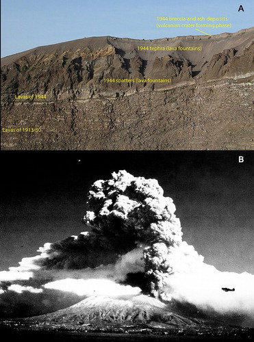
In particular, the scenario of the expected event was based on that of the AD 1631 eruption, accurately reconstructed through detailed stratigraphic works and the analysis of several contemporary chronicles (CitationBertagnini et al., 2006; CitationRosi, Principe, & Vecci, 1993). The AD 1631 eruption was followed by the last period of activity (1638–1944) during which the ‘Gran Cono’ of Vesuvius attained its present morphology. The eruptive activity of this period was split into 18 cycles characterised by summit and lateral lava effusions and semi-persistent mild explosive activity. Each cycle was closed by more intense effusive-explosive ‘final’ eruptions (CitationSantacroce, 1987), the last one occurred in 1944 (). The rise of a volatile-rich mafic magma batch triggered a mixed effusive-explosive eruption (CitationMarianelli, Metrich, & Sbrana, 1999; CitationMarianelli, Sbrana, Métrich, & Cecchetti, 2005) opened by lava effusions and followed by a violent lava fountaining phase ((B)) and by a final phreatomagmatic phase (CitationMarianelli et al., 1999, and references therein). The Vesuvius is quiescent since March 1944.
Figure 7. (A) View of the present Vesuvius crater (inner northern), deposits of Phase 4: 1913–1944 lavas (lv19 and lv20 in the main map); 1944 proximal fallout deposits (spatter ss and lapilli fallout in the main map); breccia and ashes (pc in the main map). (B) Somma-Vesuvius and 1944 plume on 24 March 1944 (photo credit: U.S. Air Force Photo Coll. Courtesy of the National Air and Space Museum, Smithsonian Institution).
3. Methods
The first step for the elaboration of the volcanological map was the collection and the graphic layout of the base map. The orographic background of the map is the result of the Lidar DTM (1 × 1 m ground resolution, Z-error ± 15 cm, years 2009–2012) and the ORCA project DTM (5 × 5 m, years 2004–2005). These two digital elevation models were mixed to produce a realistic topographic effect, using Adobe Photoshop® CC 2018. The topographic contour lines were derived from the smoothing and contouring process on the ORCA DTM, and the high-resolution Lidar DTM was also used to draw geomorphological elements such as fractures, scars, caldera and crater rims and parasitic vents (see http://sit.cittametropolitana.na.it/lidar.html).
The bathymetric reconstruction was based on the data elaboration extracted from the map ‘Golfo di Napoli’, 1:60.000 scale published by Istituto Idrografico della Marina, Genova, 1889.
The geological data are based on the CARG’88 field survey carried out at the 1:5.000 scale and on unpublished data of the authors. In this study, all data were stored and generated in a geographical information system (GIS) developed with ESRI ARCGIS® 10.6, using the cartographical reference system WGS 84-UTM 33N. Data generation in a GIS environment enables the production of the following thematic layouts:
-
orographic background of inland and offshore areas;
-
topographic and bathymetric contour lines;
-
polygonal and linear base map elements such as buildings and streets (Open Street Map);
-
polygonal, linear, and punctual features for volcanological, geological, and geomorphological elements;
-
Archaeological sites of interest (Pompei and Ercolano data extracted from CTP – Carta Tecnica Provinciale, scale 1:25.000; sheets 446 IV and 448 III);
All these layers were elaborated with Adobe Illustrator® CC 2018 and Adobe Photoshop® CC 2018 obtaining the final layout at the scale 1:20,000.
Data collected for Plate I, as isopachs of fallout and PDC deposits, main outcrops, vents and caldera rims of the different eruptions, are from a detailed revision of published and unpublished data mainly collected by the authors in the last 30 years. Published data are acknowledged in the legend of Plate I.
4. Results and discussion
The geological map (main map) is based on a reinterpretation of the volcano evolution in terms of different phases, during which the volcano changed the style of activity and some main volcano-tectonic structures progressively formed and evolved. The proposed phases mark the main steps of the volcano evolution, that will be described in detail in the following sub-sections: (i) Somma stratovolcano growth, (ii) polyphasic caldera formation, (iii) post caldera activity and, (iv) growth of Vesuvius cone. The forty-three lithostratigraphic units related to the different phases are here distinguished on the basis of their lithologic and sedimentological features, as well as in many cases by the presence of basal unconformities (mainly erosional), paleosols, reworked or variably pedogenized beds and, in a few cases, structural unconformities. We preferred not to use a stratigraphic scheme based on UBSU (Unconformably Bounded Stratigraphic Units), as for example proposed at other Italian volcanoes (CitationBranca, Coltelli, Groppelli, & Lentini, 2011; CitationFuniciello & Giordano, 2010) or similar to that used for the 1:50,000 geological map of Italy. In fact, as indicated above, the four different phases recognised in the evolution of the volcano are related to changes in the style of activity and may or not correspond to the presence of unconformable surfaces between the deposits at the scale of the entire edifice. In fact, the nature itself of volcanic activity, largely discontinuous in time, results in the frequent formation of multiple, local or more extended erosional surfaces both during the activity within a single phase or due to events that mark the passage from a phase to another.
4.1. Phase 1: Building of the Somma stratovolcano (ca. 39 ka – 22 ka)
Alternating lava flows and scoria deposits form the Somma stratovolcano, cropping out extensively along the upper slopes of Mt. Somma (see geological sketch in the main map and ) and on the scarp of the Somma caldera ((A)). The sequence exposed on the caldera wall evidences two main units: (i) a lower unit, mostly represented by weathered scoria beds and, (ii) an upper unit, formed by an alternation of thin lava flows and scoriae topped by parasitic cones (LSC in the main map; (C)). The stratigraphic succession is locally crosscut by several dykes, up to a few metres thick (CitationMarinoni, 2001; CitationPorreca et al., 2006). Few parasitic scoria and spatter cones are located on the lower slopes of Mt. Somma and in the surrounding plain buried under younger pyroclastic and volcaniclastic deposits. These have morphological evidences and crop out both in the southern and eastern sectors, in the Pompei and in the Palma Campania areas, respectively.
This sequence (LPG and LSC in the main map; (A,C)), representing the oldest outcropping products of the Somma volcanic successions, is unconformably covered by the units of Phase 2, dominated by explosive activity, which partially infill deep valleys eroded on the Somma flanks (especially in the northern sector or in the higher slopes of the eastern sector) or mantle the interfluves. The products of this activity are not exposed in the southern and western sectors of the volcano, except in few quarries in the areas of Boscoreale, where they are covered by a 20–30 m thick pyroclastic succession of the following activity.
4.2. Phase 2: Caldera formation (22 ka – AD 79)
During this period, at least four major Plinian eruptions and several lower intensity eruptions occurred. Major Plinian eruptions (Pomici di Base, Mercato, Avellino and Pompeii) were responsible of the shaping of the summit caldera (CitationCioni et al., 1999). Summit caldera collapses occurred after each Plinian eruption, each centred at slightly different locations roughly aligned along an E-W direction (). The deposits of these Plinian eruptions are always characterised by fall beds of pumice and lithics, usually alternating with and followed by deposits of dilute to concentrate PDC. Fall deposits dominate the eastern and north eastern flanks of the volcano, reflecting the direction of the dominant stratospheric winds (Plate I). PDC deposits are dispersed along the entire slopes of the volcano, from an elevation of about 500 m down to the nearby plain, where they are interstratified with the volcanoclastic deposits (forming the Somma-Vesuvius apron).
The PDC deposits show largely variable sedimentological features, from massive to stratified deposits, and from ash-dominated to breccia-like deposits. The maximum thickness of these deposits generally coincides with the termination of the main paleovalleys, where they form pyroclastic fans reaching a thickness of several metres. Thinly stratified deposits from dilute PDCs are also widely exposed on Somma slopes, irrespective of the paleotopography of the volcano. The stratigraphic relationships between the deposits of the different eruptions are complex, as they occupy paleo-depressions often cut into the deposits of the previous eruptions, resulting in a complex geometry with lateral or vertical superposition of units from different eruptions. Phase 2 deposits also comprise the products of a few subplinian events (Pomici Verdoline, AP1 and AP2 eruptions) mainly characterised by fall beds, with only minor PDC deposits. Ash deposits from long-lasting ash emission activity (AP3, AP4, AP5) locally form thick deposits on the eastern slopes of the volcano. In the time interval between 22 and 19 ka, activity along several eruptive fractures fed by latitic magmas formed spatter and scoria cones and minor lava flows along the San Severino valley (NE of slopes) and in the area upslope of Pollena village (NW Somma slopes). In the stratigraphic succession, sporadic tephra layers of possible Somma-Vesuvius provenance are also present (MA1 and MA2) as well as of at least two major eruptions of Phlegrean Fields (Agnano Pomici Principali and Agnano Monte Spina Plinian eruptions; CitationRosi & Sbrana, 1987; de Vita et al., Citation1999). As a whole, the products of this phase represent the majority of the outcropping deposits along the northern and eastern slopes of the volcano, while they are mainly covered, in the western and southern sectors, by the deposits of the following phases.
4.3. Phase 3: Post-caldera activity (AD 472 – AD 1631)
Phase 3 deposits are the result of the post-caldera activity, which comprises several eruptions mainly sourced inside the caldera. Volumetrically, this activity is dominated by the deposits of the two subplinian eruptions of AD 472 (Pollena, PPL) and AD 1631 (PMX). Both eruptions were characterised by easterly to north easterly dispersed fall beds, followed by PDC deposits spreading all over the volcano slopes (PPL) or only over its western and southern slopes (PMX). The absence of AD 1631 PDC deposits on the northern Somma slopes indicates they had not enough energy to overpass the caldera wall. These AD 1631 PDC deposits are mainly represented by massive, poorly sorted, valley-pond units, usually showing a large proportion of block-sized material (both juvenile and lithic), which flowed following the main valleys and forming pyroclastic fans at the break in slope to the plain surrounding the volcano. These PDC contributed to bury the Villa of Emperor August, I-IV century, that survived to the AD 79 eruption (CitationPerrotta, Scarpati, Luongo, & Aoyagi, 2006). Although Phase 3 deposits are dominated by the products of the AD 472 and AD 1631 eruptions, an important high-frequency, mid- to low-intensity activity also occurred between the two events. This activity is locally recorded, especially in the eastern sector, by a succession of lapilli and ash fallout layers only separated by minor reworked beds or erosional surfaces. This activity, started in AD 512, and lasted at least up to XII century. Lava flows vented from inside the caldera first overpassed the southern (and lower altitude) rim of the caldera approximately during the XI century activity, invading the southern and then the western slopes of the volcano (CitationPaolillo et al., 2016; CitationPrincipe et al., 2004). An important effusive activity possibly also accompanied the VI to X century explosive activity, being confined inside the caldera and not evident on the outer slopes of the volcano. Minor scoria cones, Fossa Monaca and Viulo vents, on the lower southern slopes of the volcano were also built up during this period.
4.4. Phase 4: Vesuvius cone (post 1631–1944)
The AD 1631 eruption marked an important change in the style of activity of the volcano, whose activity rapidly resumed with a nearly continuous open-conduit activity. Lava effusion and low-intensity explosive activity characterised this period, which was also punctuated by violent strombolian eruptions (CitationArrighi, Principe, & Rosi, 2001; CitationMarianelli et al., 2005; CitationSantacroce, 1983). The present Vesuvius cone is the result of lava and tephra accumulation during this period of activity ((A)). Although being prevalently focused in the central part of the caldera, effusive activity sometimes issued from vents on the flanks of Vesuvius cone or close to its base, and in some cases also outside of the caldera, along the slopes of the volcano (CitationPrincipe et al., 2004). The products of this activity are collectively indicated in the main map and in as Phase 4. The witnesses of this activity are the large lava flows flowing down from the caldera border to cover the southern and western sectors of the volcano. Most of these lava flows can be recognised through their morphology and attributed to the related eruptions thanks to the huge literature existing for the area since the XVIII century.
5. Final remarks and conclusions
The new volcanological map of the Somma-Vesuvius Complex presents a novel, exhaustive picture of the volcanic structures, geological history, and distribution of effusive and explosive deposits. The map represents the basic document for a correct reconstruction of the past activity and a guide for the possible impact on the territory in case of a future reactivation of the volcano. Hence, we expect that the geological map (main map) and the associated table presenting the dispersal of fallout and PDC deposits of a large number of past events (Plate I) can become a reference for any future, long-term, territorial planning and assessment of volcanic hazard in the area.
In this new map, the volcano activity is framed in different phases aimed to increase detail of the deposits of the numerous eruptions of the past 22 ka of the volcano, and to give an easier and more effective interpretative key of the volcano evolution. With respect to the other available maps of Vesuvius area, the proposed grouping of the different litostratigraphic units into some main phases, and the picture given by Plate I of the impact related to the main past explosive eruptions, represent in our opinion an important added value, as they offer a clearer and direct view of the changes occurred in the volcano through time. Easiness of reading and directness of the message brought by the large amount of geological information conveyed by the main map and Plate I are particularly important not only for their scientific content, but also for a correct dissemination of the available knowledge on the volcanic area, of absolute relevance for increasing the awareness of the several hundred thousand inhabitants living on the volcano slopes and the nearby plain.
Software
ESRI ArcGIS® 10.6 was used to produce the digital elevation model, to collect all data in GIS, and to create new features. The design of the final map layout was created using Adobe Photoshop® CC 2018 and Adobe Illustrator® CC 2018.
Supplemental Material
Download PDF (11.3 MB)Volcanological map of Somma-Vesuvius (Italy)
Download PDF (45 MB)Acknowledgements
The contribution of the CAR.G Project team, the Geological Survey of Italy, and the Istituto Superiore per la Protezione e la Ricerca Ambientale (ISPRA) and Regione Campania are acknowledged in the map. The authors are grateful to Heike Apps, José Luis Macías, Guido Ventura and Claudio Riccomini for their constructive comments and suggestions that helped to improve the quality of the manuscript.
Disclosure statement
No potential conflict of interest was reported by the authors.
Additional information
Funding
Related Research Data
References
- Andronico, D. , & Cioni, R. (2002). Contrasting styles of Mount Vesuvius activity in the period between the Avellino and Pompeii Plinian eruptions, and some implications for assessment of future hazards. Bulletin of Volcanology , 64 , 372–391. doi: 10.1007/s00445-002-0215-4
- Arrighi, S. , Principe, C. , & Rosi, M. (2001). Violent strombolian and subplinian eruptions at Vesuvius during post-1631 activity. Bulletin of Volcanology , 63 , 126–150. doi: 10.1007/s004450100130
- Bertagnini, A. , Cioni, R. , Guidoboni, E. , Rosi, M. , Neri, A. , & Boschi, E. (2006). Eruption early warning at Vesuvius: The A.D. 1631 lesson. Geophysical Research Letters . doi: 10.1029/2006GL027297
- Branca, S. , Coltelli, M. , Groppelli, G. , & Lentini, F. (2011). Geological map of Etna volcano, 1: 50,000 scale. Italian Journal of Geosciences , 130 (3), 265–291.
- Brocchini, D. , Principe, C. , Castradori, D. , Laurenzi, M. A. , & Gorla, L. (2001). Quaternary evolution of the southern sector of the Campanian Plain and early Somma-Vesuvius activity: Insights from the Trecase 1 well. Mineralogy and Petrology , 73 , 67–91. doi: 10.1007/s007100170011
- Caliro, S. , Chiodini, G. , Avino, R. , Cardellini, C. , & Frondini, F. (2005). Volcanic degassing at Somma–Vesuvio (Italy) inferred by chemical and isotopic signatures of groundwater. Applied Geochemistry , 20 , 1060–1076. doi: 10.1016/j.apgeochem.2005.02.002
- Cinque, A. , & Irollo, G. (2004). Il “volcano di Pompei”: nuovi dati geomorfologici e stratigrafici. Italian Journal of Quaternary Sciences , 17 , 101–116.
- Cioni, R. , Bertagnini, A. , Santacroce, R. , & Andronico, D. (2008). Explosive activity and eruption scenarios at Somma-Vesuvius (Italy): Towards a new classification scheme. Journal of Volcanology and Geothermal Research , 178 , 331–346. doi: 10.1016/j.jvolgeores.2008.04.024
- Cioni, R. , D’Oriano, C. , Bertagnini, A. , & Andronico, D. (2013). The 2nd to 4th century explosive activity of Vesuvius: New data on the timing of the upward migration of the post-AD 79 magma chamber. Annals of Geophysics , 56 (4), S0438–S0417. doi: 10.4401/ag-6444
- Cioni, R. , Marianelli, P. , & Sbrana, A. (1992). Dynamics of the AD 79 eruption: Stratigraphic, sedimentological and geochemical data on the successions from the Somma-Vesuvius southern and eastern sectors. Acta Vulcanol , 2 , 109–123.
- Cioni, R. , Santacroce, R. , & Sbrana, A. (1999). Pyroclastic deposits as a guide for reconstructing the multi-stage evolution of the Somma-Vesuvius caldera. Bulletin of Volcanology , 61 , 207–222. doi: 10.1007/s004450050272
- Cioni, R. , Sulpizio, R. , & Garruccio, N. (2003). Variability of the eruption dynamics during a subplinian event: The Greenish Pumice eruption of Somma-Vesuvius (Italy). Journal of Volcanology and Geothermal Research , 124 , 89–114. doi: 10.1016/S0377-0273(03)00070-2
- Dallai, L. , Cioni, R. , Boschi, C. , & D’Oriano, C. (2011). Carbonate-derived CO2 purging magma at depth: Influence on the eruptive activity of Somma-Vesuvius, Italy. Earth and Planetary Science Letters , 310 , 84–95. doi: 10.1016/j.epsl.2011.07.013
- Delibrias, G. , Di Paola, G. M. , Rosi, M. , & Santacroce, R. (1979). La storia eruttiva del complesso vulcanico Somma-Vesuvio ricostruita dalle successioni piroclastiche del Monte Somma. Rend Soc It Mineral Petrol , 35 , 411–438.
- de Vita, S. , Orsi, G. , Civetta, L. , Carandente, A. , D'Antonio, M. , Di Cesare, T. , … Southon, J. (1999). The Agnano–Monte Spina eruption in the densely populated, restless Campi Flegrei caldera (Italy). J. Volcanol. Geotherm. Res. 91 , 269–301. doi: 10.1016/S0377-0273(99)00039-6
- De Vivo, B. , Rolandi, G. , Gans, P. B. , Calvert, A. , Bohrson, W. A. , Spera, F. J. , & Belkin, H. E. (2001). New constraints on the pyroclastic eruptive history of the Campanian volcanic plain (Italy). Mineralogy and Petrology , 73 , 47–65. doi: 10.1007/s007100170010
- Funiciello, R. , & Giordano, G. ( Eds.). (2010). The Colli Albani Volcano. Geological Society of London, Special Publication IAVCEI, 3, 400pp. ISBN: 78-1-86239-307-3.
- Guidobaldi, M. P. , Camardo, D. , & Notomista, M. (2014). I carotaggi geoarcheologici nell’area della nuova caserma dei Carabinieri di Ercolano. Rivista di Studi Pompeiani , 25 , 166–170. (in Italian).
- Guidobaldi, M. P. , Camardo, D. , & Rossi, M. (2014). Portici, campagna di carotaggi geoarcheologici in piazza S. Ciro. Rivista di Studi Pompeiani , 25 , 171–173. (in Italian).
- Iacono Marziano, G. , Gaillard, F. , & Pichavant, M. (2008). Limestone assimilation by basaltic magmas: An experimental re-assessment and application to Italian volcanoes. Contributions to Mineralogy and Petrology , 155 , 719–738. doi: 10.1007/s00410-007-0267-8
- Johnston-Lavis, H. J. (1891). Geological map of Monte Somma and Vesuvius (1:10,000) constructed during the years 1880-1888 . London : George Philips & Son.
- Marianelli, P. , Metrich, N. , & Sbrana, A. (1999). Shallow and deep reservoirs involved in magma supply of the 1944 eruption of Vesuvius. Bulletin of Volcanology , 61 , 48–63. doi: 10.1007/s004450050262
- Marianelli, P. , Sbrana, A. , Métrich, N. , & Cecchetti, A. (2005). The deep feeding system of Vesuvius involved in recent violent strombolian eruptions. Geophysical Research Letters , 32 , L02306. doi: 10.1029/2004GL021667
- Marinoni, L. B. (2001). Crustal extension from exposed sheet intrusions: Review and method proposal. Journal of Volcanology and Geothermal Research , 107 , 27–46. doi: 10.1016/S0377-0273(00)00318-8
- Mele, D. , Sulpizio, R. , Dellino, P. , & La Volpe, L. (2011). Stratigraphy and eruptive dynamics of a pulsating Plinian eruption of Somma-Vesuvius: The Pomici di Mercato (8900 years B.P.). Bulletin of Volcanology , 73 , 257–278. doi: 10.1007/s00445-010-0407-2
- Paolillo, A. , Principe, C. , Bisson, M. , Gianardi, R. , Giordano, D. , & La Felice, S. (2016). Volcanology of the Southwestern sector of Vesuvius volcano, Italy. Journal of Maps , 12 , 425–440. doi: 10.1080/17445647.2016.1234982
- Peccerillo, A. (2005). Plio-quaternary volcanism in Italy ( Vol. 365). New York : Springer-Verlag Berlin Heidelberg.
- Perrotta, A. , Scarpati, C. , Luongo, G. , & Aoyagi, M. (2006). Burial of Emperor Augustus’ villa at Somma Vesuviana (Italy) by post-79 AD Vesuvius eruptions and reworked (lahars and stream flow) deposits. Journal of Volcanology and Geothermal Research , 158 , 445–466. doi:10.1016/j.jvolgeores.2006.08.00623
- Porreca, M. , Acocella, V. , Massimi, E. , Mattei, M. , Funiciello, R. , & De Benedetti, A. A. (2006). Geometric and kinematic features of the dike complex at Mt. Somma, Vesuvio (Italy). Earth and Planetary Science Letters , 245 , 389–407. doi: 10.1016/j.epsl.2006.02.027
- Principe, C. , Tanguy, J. C. , Arrighi, S. , Paiotti, A. , Le Goff, M. , & Zoppi, U. (2004). Chronology of Vesuvius_ activity from A.D. 79 to 1631 based on archeomagnetism of lavas and historical sources. Bulletin of Volcanology , 66 , 703–724. doi: 10.1007/s00445-004-0348-8
- Regione Campania . (2003). Geological map of Vesuvius 1:15,000, Regione Campania, Assessorato Difesa Suolo.
- Rittmann, A. (1933). Die geologisch bedingte evolution und differentiation des Somma-Vesuvmagmas . Berlin : Reimer.
- Rosi, M. , Principe, C. , & Vecci, R. (1993). The 1631 Vesuvius eruption. A reconstruction based on historical and stratigraphical data. Journal of Volcanology and Geothermal Research , 58 (1–4), 151–182. doi: 10.1016/0377-0273(93)90106-2
- Rosi, M. , Santacroce, R. , & Sbrana, A. (1986). Geological map of Somma-Vesuvius volcanic complex (scale 1:25,000). In R. Santacroce (Ed.), Somma-Vesuvius. Quaderni de ‘La Ricerca Scientifica’ CNR 114(8) (pp. 1–220). Roma : CNR Edizioni.
- Rosi, M. , & Sbrana, A. ( Eds.). (1987). Phlegrean fields (Vol. 9). CNR, Quad. Ric. Sci., 114 (9), 175 pp.
- Santacroce, R. (1983). A general model for the behavior of the Somma-Vesuvius volcanic complex. Journal of Volcanology and Geothermal Research , 17 (1–4), 237–248. doi: 10.1016/0377-0273(83)90070-7
- Santacroce, R. ( Editore). (1987) Somma Vesuvius. CNR, Quad. Ric. Sci., 114 (8), 220 pp.
- Santacroce, R. , Cioni, R. , Marianelli, P. , Sbrana, A. , Sulpizio, R. , Zanchetta, G. , … Joron, J. L. (2008). Age and whole rock–glass compositions of proximal pyroclastics from the major explosive eruptions of Somma-Vesuvius: A review as a tool for distal tephrostratigraphy. Journal of Volcanology and Geothermal Research , 177 , 1–18. doi: 10.1016/j.jvolgeores.2008.06.009
- Savelli, C. (1967). The problem of rock assimilation by Somma-Vesuvius magma. Contributions to Mineralogy and Petrology , 16 (4), 328–353. doi: 10.1007/BF00371529
- Sbrana, A. , Marianelli, P. , & Pasquini, G. (2018). Volcanology of Ischia (Italy). Journal of Maps , 14 (2), 494–503. doi: 10.1080/17445647.2018.1498811
- Servizio Geologico d’italia . (in press). Geological map of Italy, F 448 Ercolano, F 466 Sorrento Isola d’Ischia. 1:50000 – ISPRA Geological Survey of Italy, ISPRA Roma.
- Sevink, J. , Bergen, M. , Plicht, J. , Feiken, H. , Anastasia, C. , & Huizinga, A. (2011). Robust date for the Bronze Age Avellino eruption (Somma-Vesuvius): 3945±10 calBP (1995±10 calBC). Quaternary Science Reviews , 30 . doi:10.1016/j.quascirev.2011.02.001 .
- Sigurdsson, H. , Carey, S. , Cornell, W. , & Pescatore, T. (1985). The eruption of Vesuvius in A.D. 79. National Geographic Research , 1 , 1–55.
- Sigurdsson, H. , Cashdollar, S. , & Sparks, S. R. J. (1982). The eruption of Vesuvius in AD 79: Reconstruction from historical and volcanological evidence. American Journal of Archaeology , 86 (1), 39–51. doi: 10.2307/504292
- Stothers, R. B. , & Rampino, M. R. (1983). Volcanic eruptions in the Mediterranean before A.D. 630 from written and archaeological sources. Journal of Geophysical Research , 88 (B8), 6357–6371. doi: 10.1029/JB088iB08p06357
- Sulpizio, R. , Bonasia, R. , Dellino, P. , Mele, D. , Di Vito, M. A. , & La Volpe, L. (2010). The Pomici di Avellino eruption of Somma-Vesuvius (3.9 ka BP). Part II: Sedimentology and physical volcanology of pyroclastic density current deposits. Bulletin of Volcanology , 72 , 559–577. doi: 10.1007/s00445-009-0340-4
- Sulpizio, R. , Cioni, R. , Di Vito, M. A. , Mele, D. , Bonasia, R. , & Dellino, P. (2010). The Pomici di Avellino eruption of Somma-Vesuvius (3.9 ka BP). art I: Stratigraphy, compositional variability and eruptive dynamics. Bulletin of Volcanology , 72 , 539–558. doi: 10.1007/s00445-009-0339-x
- Sulpizio, R. , Mele, D. , Dellino, P. , & La Volpe, L. (2005). A complex, subplinian-type eruption from low-viscosity, phonolitic to tephri-phonolitic magma: The AD 472 (Pollena) eruption of Somma-Vesuvius, Italy. Bulletin of Volcanology , 67 , 743–767. doi: 10.1007/s00445-005-0414-x
- Vogel, S. , Maerker, M. & Seiler, F. (2011). Revised modeling of the post-AD 79 volcanic deposits of Somma-Vesuvius to reconstruct the pre-AD 79 topography of the Sarno River plain (Italy). Geologica Carpathica , 62 , 5–16, doi: 10.2478/v10096-011-0001-3