
ABSTRACT
The Upper Rhone Valley (Valais, Switzerland) has been heavily modified over the past 200 years by human activity and natural processes. A qualitative analysis of the morphological and land-use evolution of the Rhone River floodplain since the end of the eighteenth century was carried out using historical maps from 1780 to 1860 processed with Structure-from-Motion (SfM) and Geographical Information System (GIS) tools. This study aims to produce a long-term analysis of river management and land-use change in a stretch of the Upper Rhone Valley around the town of Sion based on a time series of maps, realised in the years 1780–1802, 1820–1845, 1847, 1850s, 1852–1857, 1859–1860. The historical maps were digitised, and for each of the corresponding periods, a map was produced within a GIS. The comparison of the maps was completed by using documentary sources or subsequent studies. With the intention to identify the fluvial landscape changes and past river management, six multitemporal maps were produced. Finally, this research aims to provide helpful diachronic information for planning a future sustainable landscape development in Valais.
1. Introduction
The interplay between geomorphological processes, land-use, ecosystems and human influence has always played a special role in the evolution of the fluvial environment since anthropogenic activities started to alter the natural processes (CitationJames & Marcus, 2006; CitationLi, Yang, Pu, & Liu, 2017). Land-use change is a dynamic process that links together natural and human systems (CitationBrandolini & Carrer, 2020). Therefore, a historical reconstruction of this process is necessary to evaluate the reciprocal interactions between anthropogenic activities and fluvial environments (CitationBollati, Reynard, Cagnin, & Pelfini, 2018). Historical maps, when available, represent a valuable resource for understanding the causes, mechanisms and consequences of the human-induced changes in fluvial features and support river management at any scale (CitationHohensinner et al., 2013; CitationPătru-Stupariu, Stupariu, Cuculici, & Huzui, 2011). Moreover, the combination of historical data with geoscience data and remote sensing analysis is essential to study the relationship of natural events such as floods and river diversions with human land-use changes through time (CitationBrandolini, Cremaschi, & Pelfini, 2019; CitationRoccati et al., 2018). In regions that are historically affected by flooding and where urbanisation has increased exposure to floods, historical cartography provides valuable indications for planning more sustainable urbanised alluvial landscapes in the future (CitationBrandolini & Cremaschi, 2018). GIS tools are essential to compare digitised historical maps with more recent ones and to carry out a multi-temporal analysis of landscape dynamics (CitationLieskovský et al., 2018; CitationStatuto et al., 2017).
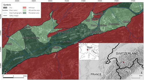
The Upper Rhone Valley is located in the Swiss Alps between the Rhone Glacier and Lake Geneva, and it is particularly interesting to study since it represents the largest inner Alpine basin with a size of c. 5244 km2. The Rhone River originates from the Furka Glacier (2341 m asl) and, with a total length of 164 km, dissects the western Swiss Alps with a general NE-SW direction upstream of Martigny and SSE-NNW direction downstream ().
Figure 1. Location of the study area and main units: hillslope, alluvial fan areas and floodplain areas.
The Upper Rhone Basin contained some of the thickest Alpine glaciers throughout the Quaternary period (CitationKelly, Buoncristiani, & Schlüchter, 2004; CitationSchlüchter, 2009), and it was characterised by subsequent advance and retreat phases due to the alternation of glacial-interglacial periods. During the Last Glacial Maximum (LGM), 22.1 ± 4.3 ka BP, the Rhone Glacier filled the Upper Rhone Basin, outflowed onto the foreland and was the main component of the LGM transection glaciers in the western Alps. The deglaciation and retreat from the LGM position started in 21.1 ± 0.9 ka BP and ice collapse already initiated between 16.8 and 17.4 ka BP (CitationSchoch A, Henrik, Hoffmann, & Schrott, 2018). The sedimentary succession presents the typical post-glacial Alpine pattern: subglacial stream deposit, lodgement till, ablation till, proglacial lacustrine deposits, glaciolacustrine deposits, bottom-set, foreset and top-set deltaic deposits, alluvial deposits (CitationStutenbecker et al., 2018). The glacial esaration influenced the mountainsides conformation, but frequently the traces of erosional processes have been covered by alluvial fans. Indeed, the tributaries of the Rhone River developed alluvial fans that influenced its course occupying a vast portion of the plain; two of them (the Illgraben fan near Sierre and the St-Barthélémy fan near Saint-Maurice) had a crucial role in modifying the Rhone River profile. Even though the nineteenth and twentieth-century channelisation profoundly rectified the river course, between Sierre and Martigny, the influence of the alluvial fans developed by the tributaries is still clearly visible on the sinuous pattern of the Rhone River (CitationReynard, 2009).
The Medieval chroniclers report the occurrence of severe flood events, and during the Little Ice Age (or LIA, 1350–1850 AD) the Upper Rhone River had certainly a torrential regime as other rivers in the Western Alps (CitationBravard, 1989). During the second half of the nineteenth century, the anthropogenic activities had a crucial impact on the Rhone basin. The river was channelized twice in the periods of 1863–1894 and 1930–1960 (the so-called ‘Corrections of the Rhone River’, see (CitationBaud, Bussard, & Reynard, 2016; Citationde Torrenté, 1964), which reduced the length of the river (CitationStutenbecker et al., 2018) and gave to the river the present-day aspect. In the 2000s, after severe flood events, the ‘Third Correction’ began following the ‘Room-for-River’ flood management strategy (CitationVis, Klijn, De Bruijn, & Van Buuren, 2003) and aims to: (1) widen the river, (2) increase the capacity, (3) secure levees and (4) improve the general environmental quality (CitationOlivier et al., 2009).
Today, the Rhone is a highly regulated Alpine river with an annual mean discharge of 1720 m3/s at its mouth and a flow regime of 17.8 L/s/km2 specific discharge (CitationOlivier et al., 2009). The flow regime of the Upper Rhone is characterised by low flows during winter while high flows occur in late spring and summer due to snowmelt (see ). Anthropogenic activities such as gravel harvesting and retention in reservoirs have altered the sediment discharge of the river: bedload transport was estimated at 1 Mm3/year at the beginning of the twentieth century, but today it is only 0.2 m3/year (CitationThareau, Giuliani, Jimenez, & Doutriaux, 2006).
Table 1. Main characteristics of the Upper Rhone River Basin (CitationOlivier et al., 2009) and the data registered at the gauging station of Sion (https://www.hydrodaten.admin.ch/en/2630.html): A – catchment area upstream of gauging station.
In the last decades several portions of the Upper Rhone River Valley were studied applying a geohistorical approach (CitationBaud et al., 2016; CitationStäuble, Martin, & Reynard, 2008; CitationZanini, Zanini, Weber, & Schlaepfer, 2006) and combining historical maps (CitationReynard, 2009) with geoscience analysis, in particular: between Riddes et Martigny (CitationBaud & Reynard, 2015; CitationLaigre, Reynard, Arnaud-Fassetta, Baron, & Glenz, 2012; CitationReynard & Baud, 2015); from Viège to Rarogne and Sierre to Sion (CitationLaigre, Arnaud-Fassetta, & Reynard, 2010); and the Conthey area (CitationStäuble & Reynard, 2005).
This research was conducted in the area around the town of Sion, precisely between Liène and Lìzerne rivers (). In this portion, the Rhone River presents a sinuous course due to the series of alluvial fans developed by its tributaries Liène, Borgne, Sionne, Printse, Morge and Lìzerne (). The aim of the study is to produce a long-term analysis of landscape changes in this section of the valley at the end of the LIA, between 1780 and 1860 AD, i.e. before the systematic river training, combining historical maps and GIS analysis. The objective is to create multi-temporal maps to highlight the main modifications due to anthropogenic land and water management activities that occurred in that period.
2. Material and methods
In recent years, historical cartography has increasingly become a fundamental source for the analysis of land-use and environmental changes (CitationLeyk, Boesch, & Weibel, 2006). In this study, the geographical reconstruction of the landscape was carried out over a period of 80 years in six time steps: 1780–1802, 1820–1845, 1847, 1850s, 1852–1857, 1859–1860. The specific historical cartography for each period was examined with the aim to create different base maps to make a comparison in time. The chosen periods were determined by the quality and quantity of historical sources available.
2.1 Historical maps
The principal maps used in the multi-temporal reconstruction of the eighteenth–nineteenth century morphology of the Rhone River floodplain and subsequent changes are listed in and include: 16 hand-drawn maps from the Archives de la Bourgeoisie de Sion (ABS) stored at the Archives de l’Etat du Valais (AEV), one hand-drawn map of the AEV, one topographic map of the Bibliothèque nationale de France in Paris and one topographic map from the Office fédéral de topographie (Swisstopo).
Table 2. List of the historical maps considered in this study. ABS: Archives de la Bourgeoisie de Sion; AEV: Archives de l’Etat du Valais. In bold style, the maps used in the ‘backdating approach’.
The ABS hand-drawn maps do not cover the territory of the research area uniformly, but they are extremely useful because they have been realised at a large scale and represent in detail the fluvial landscape appearance. On the contrary, the Swisstopo map covers the whole research area, but their small scale does not allow us to identify valuable particularities about the land-use evolution.
The Napoleonic Map was hand-drawn in watercolours by the Napoleon cartographers in 1802. The aim of this map was to plan enhancement of the Simplon road that connected Switzerland to Italy for military reasons; close to the road, the cartographers represented precisely any roads, villages, woods, fields and watercourses (CitationLechevalier, 2005).
The Dufour Map was published in the period from 1845 to 1865 using a scale of 1:100,000. It was realised with an equal-area conic projection after direct surveys in the field, and it represents the first official topographic map of Switzerland (Swisstopo). In this study, we used the original version of the plate XVII Vevey – Sion (1847) that shows the Rhone Valley before the integral river training.
The Plan du Chemin de fer (hereafter, ‘Railway Map’) was made for the construction of the Simplon railway (called Ligne d’Italie). Even if not dated with precision, it is probably contemporary to the Dufour Map and it, therefore, represents the situation of the Rhone River before the channelisation work that started around 1860.
A multi-temporal cartographic comparison was carried out to reconstruct the original morphology of this portion of the Upper Rhone Valley and to identify the most significant transformations, such as modifications to the river channel, reduction of natural and agricultural areas and urban sprawl.
2.2. Digitising process
All the historical maps considered in this research were either available in georeferenced format or were georeferenced using Ground Control Points (GCPs) identified on current cartographic sources.
The ABS maps were drawn in a different period, scale and style for the upper-middle-class people (bourgeoisie) of Sion to map their properties. These large-scale maps represent limited portions of the Rhone River floodplain in detail and served as an invaluable source of information about fluvial landscape changes. On the other hand, perspective projection and geometric foundations of the maps production process are unknown, making the georeferencing procedure in GIS problematic.
The first step of the workflow consisted of digitising the maps to be imported into the GIS software. The Napoleonic Map, the Railway Map and the Dufour Map were already digitalised by the Valais administration and Swisstopo that provided a georeferenced copy of these files. Concerning the ABS maps, the scanning would have been challenging because of their size, format and, sometimes, their state of conservation. The large size and format of some historical maps (e.g. ABS 99/36 100 × 150 cm; ABS 202/11 60 × 110 cm) would have required expensive digital scanners to capture the entire map. Moreover, in a few cases, the maps were very fragile (eg. ABS 202/12) and difficult to handle. To resolve all these issues of size and conservation, each map was digitised using a photogrammetric approach (CitationBrandolini & Patrucco, 2019) with Agisoft PhotoScan. The elaborated TIFF images (96 dpi resolution) were then imported in the open-source desktop software QGIS 3.4.
To perform the georectifying process on the ABS maps, Thin Plate Spline (TPS) and cubic resampling methods (QGIS 3.4) were employed (CitationBaiocchi, Lelo, Milone, & Mormile, 2013). A minimum of three GCPs (CitationOniga, Breaban, & Statescu, 2018) was detected to scale, rotate and locate each map but the absence of a topographic regular grid in the ABS maps made the georeferencing phase extremely challenging. In particular, the Pont du Rhône (Rhone Bridge) was the reference key point in geo-referencing ABS historical maps in association with the historical location of the river dykes and groynes. Other essential reference points were the buildings of towns’ historic centres and the geomorphological features of Châteauneuf, Tourbillon and Valère hills. Moreover, to minimise the spatial inaccuracy of the ABS maps the ‘backdating approach’ was employed (CitationBednarczyk, Kaim, & Ostafin, 2016; CitationFeranec, Hazeu, Christensen, & Jaffrain, 2007): it consists in verifying and correcting the positions of the points in older maps according to recent and most accurate maps (CitationLieskovský et al., 2018). In particular, two georeferenced copies of the historical topographic maps retrieved from Swisstopo have been employed: the Dufour Map for the ABS maps dated before the ‘First Correction’ and the Siegfried Map (1870–1922) for all the ABS maps made after 1861 (for details on these maps see (CitationStäuble et al., 2008) ). This method cannot resolve all the positional inaccuracies mainly due to scale differences (CitationKaim et al., 2016) but represents the most reliable approach to georeference ancient historical cartography when other more accurate procedures are not available (CitationLieskovský et al., 2018)
Thanks to this data processing, it was possible to make all ortho-rectified maps comparable in terms of scale and land-use classification, and it was possible to overlay them, in order to assess landscape changes. The ABS maps represent limited portions of the study area, and they have been realised in different periods with different techniques, scale, fonts and even languages. To overcome the limitations of each singular map, we combined them in mosaics of historical maps with the same chronology/style/scale and representing the same time period. For each map, the land-use changes, water uses and fluvial geomorphological features are indicated. The results consist of 6 multi-temporal maps that reconstruct the landscape evolution of this portion of the Upper Rhone Valley from 1780 to 1860.
3. Results
The characteristics of the historical cartography considered in this research were not suitable for a land-use quantitative procedure (CitationChiang, Leyk, Honarvar Nazari, Moghaddam, & Tan, 2016; CitationLeyk, Boesch, & Weibel, 2005) but enabled a qualitative interpretation on landscape evolution. The description and the main changes () for each period are presented here.
Table 3. Main characteristics for each period.
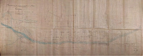
3.1. 1780–1802 (Main Map, Sheet 1/3)
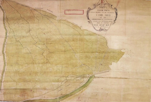
In this period, alternation of braided channels and portions of sinuous unique channel characterises the Rhone River. From the main channel, a series of sub-channels flowed around channel bars especially upstream of the confluence with the Liène River and in the area known in the present-day as Les Iles (i.e. The Islands). In the Napoleonic Map ((A)), a waterlogged area upstream to the Borgne fan in Bramois is reported. Concerning land-use, few data are available. Napoleon cartographers reported agriculture and wood zones ((A)) without indicating any details about the crops cultivated or the arbour species. ABS 99/35 and 99/36 dating back to the second half of the eighteenth century () were handy to reconstruct the division of the farmland and the owner of each field on the left side of the Borgne River on the alluvial fan (). This portion of the Borgne fan was cultivated at least since 1741 when the cadastre was compiled for the first time, but there is no indication of the specific agriculture use. In this portion of the Borgne fan, an irrigation system was active, and few channels are still active in the present day. Downstream of the Pont du Rhône woodland is common but not homogenous. This woodland fragmentation might be evidence of parallel secondary land-use probably represented by extensive pasturelands. Regarding the hydrographic elements represented in the Napoleonic Map, the Morge River and Lizerne River flowed in the Rhone River following their natural watercourses bordered by forests.
Figure 2. The study area as it is represented in the Napoleonic Plan (A), the Dufour Map (B) and the Railway Map (C). (Courtesy of ©Archives de l’Etat du Valais, AEV and Swisstopo).
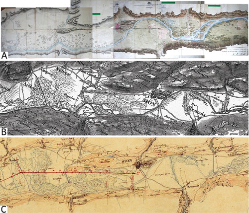
Figure 3. ‘Plan géométrique de la plaine de Champsec/Sion’ digitalised with Agisoft Photoscan (CitationBrandolini & Patrucco, 2019) (Courtesy of ©Archives de l’Etat du Valais, AEV, ABS 99/36). The map is oriented with South at the top of the map.
3.2. 1820–1845 (Main Map, Sheet 1/3)
The study of this interval is based on 9 historical maps with the same style and scale, dated between 1823 and 1845 (). The Rhone River is still partly braided with channel bars and sub-channels. The historical maps of this interval are much more detailed than the Napoleonic Map, so it was possible to reconstruct with more precision the bars features and the braided channels. Moreover, on both sides of the Rhone River dykes and groynes () testify anthropogenic activities on the river in that period. The aim was to manage the fluvial sediments to reclaim waterlogged areas and to rectify the river watercourse. The groynes, indeed, keeping the fluvial sediments, reduced the number of the sub-channels and filled the floodplain wetlands progressively. Very few indications about land-use are available for this time interval, and historical maps report only woods and meadows along the Rhone River banks.
Figure 4. ‘Plan du Rhône entre Bramois et Uvrier’ digitalised with Agisoft Photoscan (CitationBrandolini & Patrucco, 2019). (Courtesy of ©Archives de l’Etat du Valais, AEV, ABS 97/17).
The Les Iles zone represents the most interesting area to understand the river pattern evolution through the nineteenth century (see ‘Les Iles detail’ box in Multitemporal Maps, Sheets 1/3). Here the place name still indicates the presence of former fluvial bars, depicted in the Napoleonic Map and then represented in the ABS maps with more precision. Furthermore, dykes and groynes seem to have deactivated many sub-channels with the Rhone River fluvial sediments, but the presence of woods only in the centre of the channel-bars suggests that the former braided channels were probably still active occasionally. Therefore, the Rhone River in this period seems to have been characterised by a single-thread sinuous and wandering channel pattern (CitationFryirs & Brierley, 2018). Moreover, plans to build further dykes and groynes in the area are reported. The historical maps for this time interval report some particulars about the land-use along the Rhone River banks: fields, orchards or meadows are indicated even though the cultivations are unknown. The presence of orchards south of the river in the area between the Pont du Rhône and Aproz seems to indicate that the protection by the dykes was sufficient to allow, quite close to the Rhone River, land-uses more sensible to floods than meadows or forests.
3.3. 1847 and 1850s (Main Map, Sheet 2/3)
Two maps (see Main Map, 2/3) have been considered for this interval: the Dufour Map ((B)) and the Railway Map ((C)). Both these maps are extremely useful to have a general view of the Rhone River pattern in this period because they cover the whole research area. Besides that, these maps have a too small scale and present no particular details about water management or land-use. The Dufour Map reports woods and wetland areas in Praz–Pourris and around Châteauneuf and the Lìzerne River appears rectified and channelised. In the Railway Map, the Praz – Pourris wetlands occupy less area than in the Dufour Map and probably depends on the period of the year when the Plan du Chemin de fer was made. In both maps, the Rhone River seems characterised by a single-thread sinuous pattern except: (1) upstream the of Liène River and between Aproz and Ardon (braided pattern) (2) in the Les Iles area (wandering pattern) (CitationFryirs & Brierley, 2018).
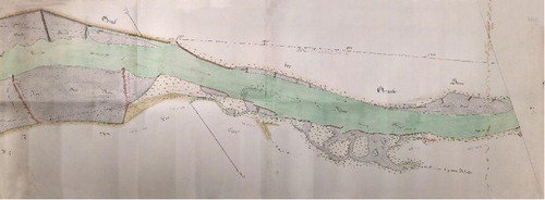
3.4. 1852–1857 and 1859 – 1860 (Main Map, Sheet 3/3)
The historical maps considered in Main Map Sheet 3/3 show the Rhone River right before the ‘First Correction’ that occurred in the 1860s (). Compared with the previous periods, the dykes and groynes system seems to have been developed mainly in Les Iles zone (see ‘Les Iles detail’ box in Multitemporal Maps, Sheets 3/3). Fields, orchards, woods are indicated generically and without any particular detail while the Rhone River seems almost completely channelised with only a locally wandering pattern.
Figure 5. ‘Plan de dessèchement des marais de la plaine de Sion (1857)’ digitalised with Agisoft Photoscan (CitationBrandolini & Patrucco, 2019) (Courtesy of ©Archives de l’Etat du Valais, AEV, ABS 202/11).
4. Discussion and conclusions
This study enabled us to understand the evolution of the Rhone River in the Sion area between the Liène and Lìzerne rivers in the final phases of the LIA. As reported in other portions of the Rhone Valley as in the Saillon area (CitationLaigre et al., 2012), at the turn between the eighteenth and nineteenth century the braided pattern of the Rhone River seems to be limited to some specific parts such as the confluence with torrential tributaries such as the Sionne or the Printse rivers, as well as particularly flat portions of the floodplain upstream of large alluvial fans such as the sector situated just upstream of the Borgne river alluvial fan. In the other sectors, the river presents a sinuous natural pattern.
The land-use was interpreted manually, which might have resulted in human-induced errors, but excluded any misclassification problems present in automatic procedures (CitationLeyk et al., 2005). Also, comparison of the land-use based on diverse cartographic sources may be influenced by the differences in definitions and map purposes (CitationLieskovský et al., 2018) for these reasons all the maps considered in this study have been analysed with the support of local historians.
The instability of the watercourse may explain the large presence of woods downstream of Sion and upstream of the Borgne alluvial fan. Nevertheless, large sectors of the plain are cultivated on alluvial fans, such as the Borgne River fan, and also in the Rhone River plain itself. Swamps have limited extension in the area. All these indices corroborate the conclusion (CitationEvéquoz-Dayen, 2009) that at the turn of the nineteenth century, the Rhone River plain was far from being unexploited and covered with swamps, as described by foreign travellers (CitationReichler & Ruffieux 1998).
From the end of the eighteenth century, the anthropogenic activities modified the natural evolution of the Rhone River, affecting the fluvial dynamics. First of all, the construction of dykes and groynes had the effect of keeping the fluvial sediments reclaiming flood-prone areas. This process took several decades and right before the first river training project (1860s) Les Iles area was still characterised by a wandering channel pattern (CitationFryirs & Brierley, 2012). Nevertheless, the presence of orchards closed to the main channel of the Rhone River in the 1840s certainly indicates that the impacts of flooding were becoming less important, partly because of the construction of various dykes in the previous years.
The use of the large-scale ABS historical maps gave us the opportunity to highlight new details about the evolution of the Upper Rhone Valley landscape at a local scale and to understand the impact of human-induced changing on the Rhone River. The main learning concerns the fact that quite systematic building of dykes and groynes happened almost 40 years before the first Rhone correction. The objective was to reduce the lateral extension of the Rhone River by building longitudinal dykes and to concentrate flows by the construction of submersible groynes. This technique that has then been used systematically during the general river training since the 1860s, not only had the objective to concentrate flow but also wanted to provoke artificial sedimentation of the spaces comprised between the dykes and groynes.
To conclude, the information about the land-use change remains limited to few indications about the occurrence of woods, fields, orchards and meadows along the river banks, but no details about the agriculture activities are available. Concerning the fluvial landscape changes, this research highlighted the impact of past flood management on the natural development of the Rhone River. Since the 2000s, local authorities have been proposing sustainable solutions to deal with climate change impacts in the Upper Rhone Basin (CitationClarvis et al., 2014). Therefore, the ‘Third Correction’ was planned to mitigate flood hazard, e.g. restoring flooding areas on selected stretches upstream of Lake Geneva (CitationKremer et al., 2015): with this aim the results of the research here proposed might serve as an indication to restore the historical appearance of the Rhone River before the ‘First Correction’. In general, multitemporal maps could represent valuable tools not only to understand the past evolution of a region but also to plan future sustainable landscape management projects.
Software
The ABS historical maps have been digitalised using the software Agisoft PhotoScan 1.4.4. Data processing and map design were performed with open-source GIS QGIS 3.4 Madeira (2018 QGIS Development Team).
Acknowledgements
The authors would like to acknowledge Alain Dubois, Director of the State Archive of Valais (AEV), and his collaborators Denis Reynard and Jean-Pierre Theytaz, as well as the historian Muriel Borgeat-Theler for her help in the transcription of some documents and proficuous discussions. The authors also thank the AEV administration and staff for giving the right to use the historical maps and for helping during the consultation of the ABS archive. We also thank the reviewers (Dominik Kaim, Peter Pisut and Martin von Wyss) and the associate editor for their useful suggestions.
Disclosure statement
No potential conflict of interest was reported by the authors.
Additional information
Funding
Related Research Data
References
- AEV . Archives Cantonales de l’Etat du Valais. Retrieved from https://www.vs.ch/aev
- Baiocchi, V. , Lelo, K. , Milone, M. V. , & Mormile, M. (2013). Accuracy of different georeferencing strategies on historical maps of Rome. Geographia Technica , 1 , 10–16.
- Baud, D. , Bussard, J. , & Reynard, E. (2016). La correction du Rhône valaisan au XIXe siècle: Un aménagement à fort impact environnemental. In P. Fournier & G. Massard-Guilbaud (Eds.), Le Rhône: Dynamique, histoire et société. Aménagement, territoires et environnement. Perspectives historiques (pp. 137–148). Rennes : Presses de l’Université de Rennes.
- Baud, D. , & Reynard, E. (2015). Géohistoire d’une trajectoire paysagère dans la plaine du Rhône valaisan. Analyse du secteur entre Riddes et Martigny (1840–1965). Norois , 237 , 15–31. doi: 10.4000/norois.5761
- Bednarczyk, B. , Kaim, D. , & Ostafin, K. (2016). Forest cover change or misinterpretation? On dependent and independent vectorisation approaches. Prace Geograficzne , 3 , 19–30.
- Bollati, I. , Reynard, E. , Cagnin, D. , & Pelfini, M. (2018). The enhancement of cultural landscapes in mountain environments: An artificial channel history (Torrent-Neuf, Canton Valais, Switzerland) and the role of trees as natural archives of water flow changes. Acta geographica Slovenica , 58 , 87–100. doi: 10.3986/AGS.4137
- Brandolini, F. , & Cremaschi, M. (2018). The impact of late Holocene flood management on the Central Po plain (Northern Italy). Sustainability , 10 , 3968. doi: 10.3390/su10113968
- Brandolini, F. , Cremaschi, M. , & Pelfini, M. (2019). Estimating the potential of archaeo-historical data in the definition of geomorphosites and geo-educational itineraries in the Central Po plain (N Italy). Geoheritage ,
- Brandolini, F. , & Patrucco, G. (2019). Structure-from-motion (SFM) photogrammetry as a non-invasive methodology to digitalize historical documents: A highly flexible and low-cost approach? Heritage Review (Bismarck, ND), 2 , 2124–2136. doi: 10.3390/heritage2030128
- Brandolini, F. , & Carrer, F. (2020). Terra, silva et paludes. Assessing the role of alluvial geomorphology for Late-Holocene settlement strategies (Po Plain – N Italy) through Point Pattern Analysis. Environmental Archaeology: The Journal of Human Palaeoecology.
- Bravard, J.-P. (1989). La métamorphose des rivières des Alpes françaises à la fin du Moyen-Age et à l’époque moderne. Bulletin de la Société Géographique de Liège , 25 , 145–157.
- Chiang, Y.-Y. , Leyk, S. , Honarvar Nazari, N. , Moghaddam, S. , & Tan, T. X. (2016). Assessing the impact of graphical quality on automatic text recognition in digital maps. Computers & Geosciences , 93 , 21–35. doi: 10.1016/j.cageo.2016.04.013
- Clarvis, M. H. , Fatichi, S. , Allan, A. , Fuhrer, J. , Stoffel, M. , Romerio, F. , … Toreti, A. (2014). Governing and managing water resources under changing hydro-climatic contexts: The case of the upper Rhone basin. Environmental Science & Policy , 43 , 56–67. doi: 10.1016/j.envsci.2013.11.005
- de Torrenté, C. (1964). La correction du Rhône en amont du Lac Léman . Berne : Département fédéral de l’intérieur.
- Evéquoz-Dayen, M. (2009). Des sources pour l’étude du Rhône valaisan. In E. Reynard , M. Evéquoz-Dayen , & P. Dubuis (Eds.), Le Rhône: dynamique, histoire et société (Vol. 21. pp. 47–62). Sion : Cahiers de Vallesia.
- Feranec, J. , Hazeu, G. , Christensen, S. , & Jaffrain, G. (2007). Corine land cover change detection in Europe (case studies of the Netherlands and Slovakia). Land Use Policy , 24 , 234–247. doi: 10.1016/j.landusepol.2006.02.002
- Fryirs, K. A. , & Brierley, G. J. (2012). Geomorphic analysis of river systems: An approach to reading the landscape . Chichester : John Wiley & Sons.
- Fryirs, K. A. , & Brierley, G. J. (2018). What’s in a name? A naming convention for geomorphic river types using the River Styles Framework. PLoS One , 13 , e0201909. doi: 10.1371/journal.pone.0201909
- Hohensinner, S. , Lager, B. , Sonnlechner, C. , Haidvogl, G. , Gierlinger, S. , Schmid, M. , … Winiwarter, V. (2013). Changes in water and land: The reconstructed Viennese riverscape from 1500 to the present. Water Hist , 5 , 145–172. doi: 10.1007/s12685-013-0074-2
- James, L. A. , & Marcus, W. A. (2006). The human role in changing fluvial systems: Retrospect, inventory and prospect. Geomorphology , 79 , 152–171. doi: 10.1016/j.geomorph.2006.06.017
- Kaim, D. , Kozak, J. , Kolecka, N. , Ziółkowska, E. , Ostafin, K. , Ostapowicz, K. , … Radeloff, V. C. (2016). Broad scale forest cover reconstruction from historical topographic maps. Applied Geography (sevenoaks, England) , 67 , 39–48. doi: 10.1016/j.apgeog.2015.12.003
- Kelly, M. A. , Buoncristiani, J.-F. , & Schlüchter, C. (2004). A reconstruction of the last glacial maximum (LGM) ice-surface geometry in the western Swiss Alps and contiguous Alpine regions in Italy and France. Eclogae Geologicae Helvetiae , 97 , 57–75. doi: 10.1007/s00015-004-1109-6
- Kremer, K. , Corella, J. P. , Hilbe, M. , Marillier, F. , Dupuy, D. , Zenhäusern, G. , & Girardclos, S. (2015). Changes in distal sedimentation regime of the Rhone delta system controlled by subaquatic channels (Lake Geneva, Switzerland/France). Marine Geology , 370 , 125–135. doi: 10.1016/j.margeo.2015.10.013
- Laigre, L. , Arnaud-Fassetta, G. , & Reynard, E. (2010). Cartographie sectorielle du paléoenvironnement de la plaine alluviale du Rhône suisse depuis la fin du Petit Age Glaciaire: la métamorphose fluviale de Viège à Rarogne et de Sierre à Sion. Bull Murithienne , 127 , 7–17.
- Laigre, L. , Reynard, E. , Arnaud-Fassetta, G. , Baron, L. , & Glenz, D. (2012). Caractérisation de la paléodynamique du Rhône en Valais central (Suisse) à l’aide de la tomographie de résistivité électrique. Géomorphologie: Relief, Processus, Environnement , 18 , 405–426. doi: 10.4000/geomorphologie.10020
- Lechevalier, M. (2005). La mission del ingénieurs géographes français en Valais en 1802. Vallesia , 60 , 411–431.
- Leyk, S. , Boesch, R. , & Weibel, R. (2005). A conceptual framework for uncertainty investigation in map-based land cover change modelling. Transactions in GIS , 9 , 291–322. doi:10.1111/j.1467-9671.2005.00220.x.
- Leyk, S. , Boesch, R. , & Weibel, R. (2006). Saliency and semantic processing: Extracting forest cover from historical topographic maps. Pattern Recognition , 39 , 953–968. doi: 10.1016/j.patcog.2005.10.018
- Li, J. , Yang, L. , Pu, R. , & Liu, Y. (2017). A review on anthropogenic geomorphology. Journal of Geographical Sciences , 27 , 109–128. doi: 10.1007/s11442-017-1367-7
- Lieskovský, J. , Kaim, D. , Balázs, P. , Boltižiar, M. , Chmiel, M. , Grabska, E. , … Antalová, K. (2018). Historical land-use dataset of the Carpathian region (1819–1980). Journal of Maps , 14 , 644–651. doi: 10.1080/17445647.2018.1502099
- Olivier, J.-M. , Dole-Olivier, M.-J. , Amoros, C. , Carrel, G. , Malard, F. , Lamouroux, N. , & Bravard, J.-P. (2009). Chapter 7 – The Rhône River Basin. In K. Tockner , U. Uehlinger , & C. T. Robinson (Eds.), Rivers of Europe (pp. 247–295). London : Academic Press.
- Oniga, V.-E. , Breaban, A.-I. , & Statescu, F. (2018). Determining the optimum number of ground control points for obtaining high precision results based on UAS images. Proceedings , 2 , 352. doi: 10.3390/ecrs-2-05165
- Pătru-Stupariu, I. , Stupariu, M.-S. , Cuculici, R. , & Huzui, A. (2011). Understanding landscape change using historical maps. Case study Sinaia, Romania. Journal of Maps , 7 , 206–220. doi: 10.4113/jom.2011.1151
- Reichler, C. , & Ruffieux, R. (1998). Le voyage en Suisse: anthologie des voyageurs français et européens de la Renaissance au XXe siècle . Paris : R. Laffont.
- Reynard, E. (2009). Les sources cartographiques pour l’histoire du Rhône valaisan. In E. Reynard , M. Evéquoz-Dayen , & P. Dubuis (Eds.), Le Rhône: dynamique, histoire et sociét (Vol. 21. pp. 63–71). Sion : Cahiers de Vallesia.
- Reynard, E. , & Baud, D. (2015). Etude géohistorique de l’assèchement de la plaine de Riddes-Martigny (1910-1940). Vallesia , 70 , 255–291.
- Roccati, A. , Luino, F. , Turconi, L. , Piana, P. , Watkins, C. , Faccini, F. , … Piana, P. (2018). Historical geomorphological research of a Ligurian coastal floodplain (Italy) and Iis value for management of flood risk and environmental sustainability. Sustainability , 10 , 3727. doi: 10.3390/su10103727
- Schlüchter, C. (2009). Die Schweiz während des letzteiszeitlichen Maximums (LGM), 1:500 000. GeoKarten 500.Wabern, editor . Bern : Bundesamt für Landestopografie swisstopo.
- Schoch A, B. , Henrik, J. , Hoffmann, T. , & Schrott, L. (2018). Multivariate geostatistical modeling of the spatial sediment distribution in a large scale drainage basin, Upper Rhone, Switzerland. Geomorphology , 303 , 375–392. doi: 10.1016/j.geomorph.2017.11.026
- Statuto, D. , Cillis, G. , Picuno, P. , Statuto, D. , Cillis, G. , & Picuno, P. (2017). Using historical maps within a GIS to analyze two centuries of rural landscape changes in Southern Italy. Land , 6 , 65. doi: 10.3390/land6030065
- Stäuble, S. , Martin, S. , & Reynard, E. (2008). Historical mapping for landscape reconstruction. Examples from the Canton of Valais (Switzerland). In: Mountain mapping and visualisation: 6th ICA Mountain Cartography Workshop, 11–15 Feb 2008 (pp. 211–217), Lenk, Switzerland.
- Stäuble, S. , & Reynard, E. (2005). Evolution du paysage de la plaine du Rhône dans la région de Conthey. Les apports de l’analyse des cartes historiques. Vallesia , 60 , 433–456.
- Stutenbecker, L. , Delunel, R. , Schlunegger, F. , Silva, T. A. , Šegvić, B. , Girardclos, S. , … Loizeau, J.-L. (2018). Reduced sediment supply in a fast eroding landscape? A multi-proxy sediment budget of the upper Rhône basin, Central Alps. Sedimentary Geology , 375 , 105–119. doi: 10.1016/j.sedgeo.2017.12.013
- Swisstopo . Federal Office of Topography Swisstopo. Retrieved from https://www.swisstopo.admin.ch
- Thareau, L. , Giuliani, Y. , Jimenez, C. , & Doutriaux, E. (2006). Managing sedimentation in the Swiss Rhone and Génissiat reservoir. Dams and Reservoirs, Societies and Environment in the 21st Century, Two Volume Set: 1243–1249. doi:10.1201/b16818-194 .
- Vis, M. , Klijn, F. , De Bruijn, K. M. , & Van Buuren, M. (2003). Resilience strategies for flood risk management in the Netherlands. International Journal of River Basin Management , 1 , 33–40. doi: 10.1080/15715124.2003.9635190
- Zanini, F. , Zanini, E. , Weber, C. , & Schlaepfer, R. (2006). Analyse de la dynamique du paysage de la plaine du Rhône de 1850 à 2003 sur la base de cartes topographiques. Bull Murithienne , 124 , 89–98.