
ABSTRACT
The interaction between geomorphological processes and anthropogenic activities produces an impressive association of geomorphological and archaeological heritage in urban contexts. We analyzed the urban geomorphology and the geo- and cultural heritage in the town of Pavia (N Italy). The city is located in a strategic position, on a series of fluvial terraces where the Romans founded a colony, probably in the place of an Iron Age Gaul settlement. In Medieval Times and the Modern Era, Pavia sprawled outside the Roman walls, creating new urban areas and modifying the landscape. Geomorphological and GIS-spatial analyses integrated with anthropic landform surveying, archaeological data and historical cartography were performed. This multi-disciplinary approach allowed an investigation into how urban development was firstly adapted and then superimposed onto fluvial landforms. As a result, a flexible geocultural itinerary is proposed for linking geoheritage with cultural heritage, and for disseminating urban geomorphology key-concepts.
1. Introduction
Urban geomorphology and urban geoheritage are becoming topics that are of growing interest, as they represent the starting point in understanding the relationship between natural modelling processes and anthropic activities, in geoheritage assessment and geoarchaeological studies (CitationCardarelli et al., 2004; CitationCremaschi et al., 2018; CitationDall’Aglio et al., 2011; CitationDall’Aglio et al., 2017; CitationDel Monte et al., 2016; CitationGiordano et al., 2016; CitationLewin, 2010; CitationMozzi et al., 2018; CitationNinfo et al., 2016; CitationPica et al., 2016; CitationRhoads et al., 2016; CitationStefani & Zuppiroli, 2010). In the beginning, the geomorphological landscape was determinant for village and settlement positioning (CitationBenito-Calvo & Pérez-González, 2015; CitationCremaschi et al., 2018), but afterwards, human activities progressively became more incisive in reworking morphological features and in conditioning surface geomorphic processes. Effects and impacts are nowadays more evident in heavy populated urban areas where landforms can be dismantled, buried and reworked with consequences in terms of hazard and risk (CitationAcquaotta et al., 2018) as well as in terms of geoheritage degradation and masking (CitationClivaz & Reynard, 2017; CitationGarcia et al., 2019). At the same time, cultural heritage has been growing, acquiring value in relation to the archaeological, historical, architectural components, together with the geomorphological component (CitationBrandolini et al., 2019).
Alluvial plains always represented key sites for settlements as fluvial deposition generated available terrains for settling, while river patterns naturally delimited plain portions establishing the first natural defense, even if living near rivers means living under the risk of flooding (CitationBrandolini et al. 2020; CitationBrandolini & Carrer, 2020). In this sense, land and water management activities sometimes helped to reduce flood hazards, but in other cases induced a higher hazard scenario (CitationFaccini et al., 2018). Where landforms have been deeply modified in urban contexts, some geomorphic features and geomorphosites (sensu CitationPanizza, 2001; CitationPelfini & Bollati, 2014; CitationReynard & Panizza, 2005) can be still recognized, thanks to specifics of urban features, to historical documents and to an integrated approach in investigations (CitationBrandolini et al., 2019). In this sense, geo-archaeological and historical data are crucial to understanding the geomorphological evolution of city centers as demonstrated by Rome (CitationDel Monte et al., 2016; CitationPica et al., 2016) and by other famous Mediterranean towns like Genoa, Naples, Palermo and Patras (CitationBrandolini et al., 2019).
In this study we analyzed the urban geomorphological development of the town of Pavia (Central Po Plain, Northern Italy) in the last two millennia, in order to: i) highlight and map the former topographic and geomorphic features in relation to artefacts; ii) propose a flexible itinerary useful for disseminating cultural and geo-heritage in the city context, as well as the effects of urban growth on fluvial landforms.
The city of Pavia was selected as it is considered an important and representative fluvial town (CitationGisotti, 2016). Pavia represents an urbanistic model typical for the Po plain (CitationDall’Aglio et al., 2011; CitationGisotti, 2016).
2. The study area and geomorphological setting
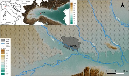
The mapped area lies inside the Lombardy region (Northern Italy) (). The town of Pavia is located on a series of fluvial terraces in the western part of the Central Po Plain, a few kilometers upstream from the confluence of the Ticino River into the Po River and approximately 45 km south of Milan.
Figure 1. Location of the study area.
The current morphology of the plain sector within which Pavia rises is fundamentally due to the rivers’ activity that from the Pleistocene to the present have shaped the landscape through alternating phases of sedimentation and incision. The river terraces are the most striking and characteristic elements, but also other typical features of alluvial plains, such as fluvial ridges, crevasse splay, traces of abandoned riverbed and scarps, can be found (CitationCastiglioni et al., 1997).
The portion of the plain to the north of the Po River is a wide surface, clearly defined by terrace borders, known as ‘Livello fondamentale della pianura’ (‘Main Surface of the Plain’, MSP, ), interpreted as the product of fluvioglacial and fluvial aggradation phases of the pede-Alpine plain, as a consequence of the Last Glacial Maximum (CitationCastiglioni & Pellegrini, 2001). In the late Pleistocene, this surface was abandoned by the main rivers that, under the changes in the climatic conditions that marked the passage to the Holocene, began to deepen the plain itself digging increasingly higher scarps. The series of Holocene valleys, one entrenched inside the other, within which the rivers Po, Ticino, Adda, Oglio, etc. flow, are the result of this activity (CitationRavazzi et al., 2012). Alternating phases of erosion and deposition also took place during the Holocene. The result was a remarkable articulation of the plain, with high terraces overlooking the river below, constituting areas that, from a strategic and functional point of view, were the primary object of the settlement choices by ancient populations.
Some of these geomorphological features can be considered geosites (sensu CitationWimbledon, 1999). More specifically, landforms can be considered geomorphosites (i.e. sites of geomorphological interest; sensu CitationPanizza, 2001) when they acquire values for their scientific, cultural, economic and scenic component (CitationBollati et al., 2017a) in relation to human perception (CitationGaravaglia et al., 2012; CitationPanizza & Piacente, 2003). Geosites nowadays can be identified both in urban and peri-urban contexts. Inside the municipal boundary, geomorphosites are mainly masked or modified by human reworking, while in city surroundings, they testify to ancient fluvial activity. Two examples are represented by the ‘Dosso Boschetto’ (Boschetto fluvial ridge), which rises about 4-6 m on the surrounding plain testifying juxtaposition of fluvial ridges and/or river bars and the ‘Cuspide di terrazzo di Cascina Santa Sofia’ (Cascina Santa Sofia terrace cusp). This latter is the result of the meandering river channel, which dismantled an intermediate terrace because of lateral erosion. (CitationPellegrini & Vercesi, 2005; CitationTozzi, 1995).
3. Historical urban development
The city of Pavia lies on a system of fluvial terraces that slope down towards the Ticino river (58 m a.s.l.) from the MSP through a series of terraces. Although the large surface available allowed the new urban layout to be perfectly adapted to the plain morphological features, the relatively high difference in altitude between the intermediate and lower terraces was not taken as a limit for the town. During its growth from South-West to North-East the city crossed those escarpments that show local differences in height as great as 10 meters, especially near the River Ticino (). This evolution model can be related to the aim of privileging a direct relationship with the river in order to control it (CitationTozzi, 1974). Moreover, in this way, it was possible to exploit terrace springs that were found in correspondence with the terrace scarps (CitationTozzi, 2005).
Figure 2. Historical urban development of Pavia.
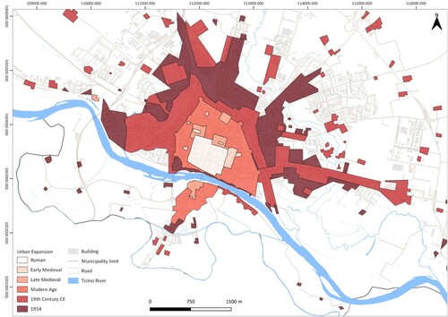
The geomorphological setting of Pavia and surroundings guided the choice for the first human settlements. The Roman colony of Ticinum, (Roman name of Pavia) was founded in 89 BCE on the banks of the River Ticino, probably replacing a former Gaul village (CitationTozzi, 2007). The valleys cut by the Ticino and by two minor watercourses Navigliaccio and Vernavola, delimited an area that was well defended naturally. Moreover, the town core was artificially delimited by two branches of the ancient Carona stream: Carona degli Orti and Carona Magistrale (CitationDall’Aglio et al., 2011) ( and ). The Roman plan of the city consisted of squared districts defined by a regular grid of roads (cardi and daecumani) still recognizable in the historic city center layout. During the Middle Ages, the city expanded especially to the North and East as new royal palaces, churches and monasteries were founded (CitationBlake, 1995; CitationHudson, 1981; CitationNepoti, 2000). In 1359 CE the city of Milan conquered Pavia and its ruler, Galeazzo II Visconti, promoted the establishment of a new castle (the Visconti Castle; CitationVicini, 1991) that was built at an altitude of about 80-82 m on the MSP. In the Modern Age, the battle of Pavia (1525 CE) marks a watershed in the city’s fortunes, with the beginning of the Spanish occupation which lasted until 1713, after which the city was ruled by the Austrians until 1796. After the Napoleonic period (1815), it returned under Austrian control until the Second War of Italian Independence in 1859. In the nineteenth century, the most relevant intervention on the urban assessment of Pavia was the opening of a new artificial waterway that connects Milan to the Ticino River: the Naviglio Pavese canal. This 33 km waterway was completed in 1819 and was intensively used for commercial purposes until the beginning of the twentieth century CE. During the twentieth century, the city’s historic city center spread, reaching its current extension ()
Figure 3. Locations of the itinerary stops.
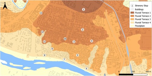
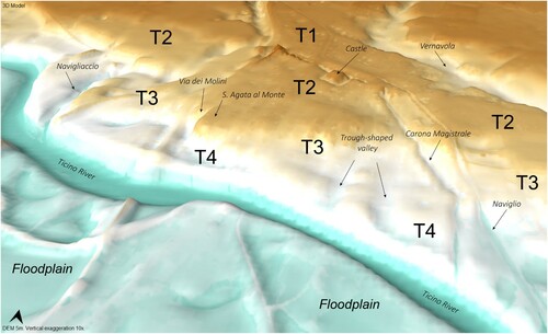
Figure 4. 3D model of the fluvial terrace sequence of Pavia (vertical exaggeration 10x).
4. Methods
To achieve an interdisciplinary understanding of the interplay between geomorphological processes and human activities, geomorphological survey and GIS-spatial analyses were integrated with field surveying, archaeological data and historical cartography.
A detailed geomorphological survey was carried out, as the current morphology of the city’s slopes has undergone an anthropic reworking over the centuries, that sometimes makes the distinction between natural and Man-made forms challenging.
The cartographic effort on the study area took place mainly through remote sensing, with the acquisition and processing of topographical and geomorphological data to be compared with the historical-archaeological data. To draw the Main Map, we acquired field data and data available from several archives. Reference topography was derived from Digital Elevation Model (5-meters resolution) retrieved online from the Geoportale of the Lombardia Region (http://www.geoportale.regione.lombardia.it/) and elaborated through software GRASS 7 (OSGeoProject) to fix DEM resolution (tool r.map.calc). The historical-archaeological data were extracted from historical cartography retrieved from the archive of Pavia Civic Museum (available online http://www.museicivici.pavia.it/paviainweb/cartografia). Some of the historical maps of Pavia were scanned using a high-resolution and contactless methodology based on SfM-photogrammetry (CitationBrandolini & Patrucco, 2019) and then imported in QGIS 3.4 (OSGeoProject) to be georeferenced (Georeference plug-in). Symbols refer to the last version of the geomorphological maps legend edited by the Italian Institute for Environmental Protection and Research-ISPRA (CitationCampobasso et al., 2018), and the geo-anthropic elements were used according to CitationDel Monte et al. (2016).
The geoheritage literature on fluvial (CitationBrandolini et al., 2019) and urban landscapes (CitationPelfini et al., 2018; CitationPica et al., 2016; CitationReynard et al., 2017) helped in the definition of the thematic itinerary on geocultural heritage here proposed. In order to detect the most evident variations in altitude of the town, crossing the terraces of the different orders, a series of topographic transects were performed. The QGIS Profile tool was used to extract the topographic profiles from the DEM. Some elements were chosen to be crossed by the profiles: i) terrace scarps and river edges (CitationDall’Aglio et al., 2011; CitationMorandotti, 1934; CitationTozzi, 1995); ii) historically relevant elements (bridges, churches, ancient spas) the locations of which were mainly guided by the geomorphological elements.
5. Results
The Main Map synthesizes the geomorphological evidence still recognizable in the urban context of Pavia and shows the transformation of fluvial landforms into anthropic landforms. Moreover, it highlights the proposed 13 geo-cultural stops, which allow to walk on and cross the modified fluvial terraces, from the main surface of the plain to the Ticino river.
5.1. Geomorphological overview on the Pavia city center
The main map and show the distribution of the original fluvial features and the range of anthropic modifications. At first glance, it is possible to recognize the naturally defended area on which the historical center of the city is located (delimited by natural watercourses). At the same time, it is possible to grasp the result of the anthropic action that has remodeled the natural boundaries by incising escarpments (man-made scarp edges e.g. stop 13). The historical city center rises on the fluvial terraces () starting with MSP (Terrace order 1; T1) where the Visconti Castle was built and slowly descending to the river course occupying the successive terraces of second, third and fourth order. The Terrace order 2 (T2) edge and scarp show how these latter represented an important source of water for people thanks to water springs (stop 3). The water use is also documented by a network of roman pipes (stop 10). Moreover, the effect of running and channeled water cutting T2 is evident (Stop 12) where a V-shaped incision is reported (Main Map).
Somewhere the watercourse dynamic has dramatically reduced the Terrace Order 3 (T3), bringing almost into contact the Terrace Order 4 (T4) and T2 as evidenced by a steep street (Stop 8). T3 is well represented by stop 9, where the mural painting by Bernardino Lanzani (1522) shows the urban planning of the city, its declivity toward the river, and the related access to the riverbank (see stop 9 description). Analogously, the perspective of the city from stop 7 (T4) highlights the anthropic remodeling interventions to reach the Castle on T1.
5.2. The geocultural itinerary
A Geocultural Itinerary (GI from now on) is proposed (). This can be considered a flexible itinerary as several sites (13) have been selected as meaningful geostops linked with cultural features. Geostops in an urban context can be progressively reached via different paths, walking different streets and squares.
The GI runs through the city center, inside the Modern Age city-walls, from the Visconti Castle till the Ticino River (stop 1-7), crossing the various terraced surfaces. Then the itinerary, moving from stop 7 to 13, allows the observation of more characteristics of T4-T2, human artificial channels and trenches, going finally up towards the railway station.
Description of the 13 geostops forming the proposed urban cultural itinerary:
- Piazza Castello (n.1, in ). The castle lies on the southern edge of the Pleistocene MSP, the highest and oldest terraced surface of the area, extending northwards without interruption, referred here as T1 ().
- University main building (n.2 in ). Like most of the city center, it is located on the terraced Holocene surface (T2; ) which is lower (less than about 3 meters) than the surface of the Castle area. The University courtyards present a large variety of stones constituting the architectonic elements that offer the opportunity for observations on lithodiversity (CitationSacchini et al., 2018) and stone provenance.
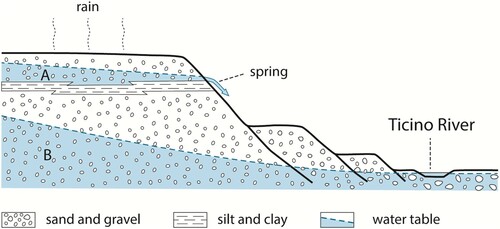
- San Tommaso building (Piazza del Lino) (n.3; ). The building is located on the edge of surface T2 and partly also on its scarp. The historical sources identify here as the place of foundation of the city, describing the site as being rich in water springs. Indeed, the high scarp, which cuts the T2 terrace, highlights the impermeable silty deposits that support an aquifer below the gravel (). When this water table is loaded, the springs, intercepted by the scarp, are activated (CitationTozzi, 2017).
- Piazza Municipio (n.4 in ). The square lies on the edge of T2, and the steep Via Porta runs transversally to the terrace scarp. This scarp, towards the East, shows a clear change of direction as evidence of a meandering river channel during the ancient incision phase ().
- San Michele Church (n.5 in ). It is located on T3 () the surface of which is discontinuous, as a consequence of the lateral river erosion or due to the incision of small valleys, developed perpendicularly to the River Ticino into which they flow. It seems that part of the churchyard was extended with artificial fillings. The church was built using sandstones with carbonate cement (Monte Arzolo sandstones), outcropping relatively near the town and characterized by pleasant colors. Despite the high malleability of the material, chemical weathering on this lithotype is responsible for ruining stones and artistic sculpture.
- Porta Nuova (n.6 in ). It is located in the lower area of the city (T4, ) and is separated from the river by a high artificial levee on which a road runs. Despite the levee, during the major floods, this area may be flooded.
- Piazzale Lungo Ticino (n.7 in ). The perspective of the city from this point of view highlights the upward development and the anthropic remodeling interventions to allow the road (Corso Strada Nuova) leading to the castle to overcome the height difference of about 18-20 meters. Looking at the watercourse, the riverbank defenses and some lateral and mid-channel bars can be observed. On the right bank, opposite Pavia city center, the ‘Borgo Ticino’ district is located. It lies on a level approximately similar to T4 and houses without defence works are frequently submerged by floods. The last flood was in 2019 when during the night between 24th and 25th November, the Ticino overflowed the banks in the area of Borgo Basso (Borgo Ticino neighborhood).
- Porta Calcinara (n.8 in ). This lower area is at the same altitudinal level of Porta Nuova (T4); a very steep street (Via Rotari dei Longobardi) leads directly to T2, T3 not being present.
- San Teodoro Church (n.9 in ). Not far from Porta Calcinara, San Teodoro Church is located on a portion of T3. Here an interesting mural painting by Bernardino Lanzani (1522) is present: the town seems to ‘rise’ from the river while the Abbot Antonio protects the town from the French soldiers. Together with its cultural and historical value, this piece shows the urban planning of the city, its declivity towards the river, and the related access to the riverbank.
- Piazza del Duomo and Piazza della Vittoria (n.10 in ). The itinerary returns to the T2 terraced surface, where, in 1960, the excavation for the underground market brought to light important Roman remains, represented by an impressive network of sewer pipes (CitationTozzi, 2007).
- Sant’Agata al Monte (n. 11 in ). The place-name (today Piazza XXIV Maggio) refers to the existence of a Medieval monastery settled in a topographically higher position than the surrounding neighborhood. This church was established in the 7th century CE in a prominent position on terrace T2 (about 76.5 m a.s.l.), hanging directly on T4 terrace. The monastery was dismantled at the beginning of the twentieth century CE. The only remnants of this hidden archaeo-geomorphosite consist of some stone epigraphs that were reused to construct the building that replaced the medieval Sant’Agata Church (CitationTolomelli, 2000).
- Via dei Molini (n.12 in ). Today we can still recognize depressions oriented almost N-S that were probably incised by the waters running towards the Ticino (see the Main Map). Some of these were run through by canals used for various human needs. The Via dei Molini was probably crossed by the ‘Carona dei Molini’ a canal, now not very evident, serving these mills.
- Viale Cesare Battisti (n. 13 in ). On the side of via Cesare Battisti, on the other hand, there is a deep valley that had to be scoured by the ‘Carona degli Orti’, to irrigate urban vegetable gardens in the past. The latter could have constituted an ancient limit to the city on the western side.
6. Discussion
Geomorphological reconstructions in urban areas are strategic for better understanding of the geomorphic dynamic, especially when this latter has been deeply modified by human interventions. This is crucial in fluvial environments where urban development has been responsible, for example, for the drainage of the rivers or the coverage of riverbeds (CitationBrandolini et al., 2018).
Figure 5. Schematic representation of a terrace water spring. The schematic section of the terraced system highlights a silty bed that supports a water table that feeds some springs at the terrace slope. A – perched aquifer; B – phreatic aquifer. The wealth of sources, in an exemplary way, was celebrated by Opicino de Canistris in sixteenth century CE (CitationTozzi, 2017) who remembers ‘in the center of the city, under the St. Thomas church, a very copious and beautiful spring'.
In this work, a great contribution to the reconstruction of the ancient fluvial landscape in Pavia comes from a detailed field survey, which includes field measurements of street slopes in different points of the city, and from a careful research of archaeological and historical data carried out both during the present and previous researches. This permits us to know the role of anthropogenic activities in reshaping the landscape.
So the use of an integrated approach for reconstructing urban geomorphology and history undoubtedly represents a key strategy not only for a better knowledge of today’s city features and characteristics but also to better comprehend fluvial dynamics and possible risk scenarios, as well as urban landscape as a cultural resource (CitationPelfini et al., 2018). In this sense, it is important to analyze not only fluvial dynamics but also the complex of water-driven processes as generally considered also for different morphogenetic and morphoclimatic environments (CitationBollati et al., 2017b).
The growing attention paid to urban geomorphology (e.g. CitationReynard et al., 2017) and to geomorphological legend that in Italy has been recently updated (CitationCampobasso et al., 2018), including detailed symbols for anthropic landforms and for geoheritage, has given significant help in constructing the Main Map. Nevertheless, the detail of the main map here presented required the introduction of specific symbols (e.g.‘V-shaped incision’) among the anthropogenic landforms. In any case, it is important to organize an easily adaptable legend, which allows the combining of colors referring to natural genetic processes with anthropic ones (e.g. CitationPica et al., 2016).
The choice of the geostops is conditioned by the necessity to highlight the city center structure in relation with fluvial geomorphology and in particular, the presence of terraces of different orders, other geomorphic features like fluvial erosion scarps and man-made scarp edges, and processes (e.g water spring stop 3). Moreover, the choice of stops is linked with human history and cultural aspects (e.g. stop 9).
These considerations represent the bases on which our multi-thematic itinerary has been realized. The 13 geostops follow the increasing terrace numbers (from T1 to T4 and return) and, at the same time, they permit the observation of the natural and human-controlled fluvial changes and cultural sites. It can be considered a flexible itinerary; in fact, selected points (geostops), sequentially linked to each other, can be reached by walking different streets and squares. This is particularly suitable for urban contexts.
7. Conclusions
The proposal of a thematic itinerary on geocultural heritage in Pavia, based on urban geomorphology represents a key strategy to raise awareness about the dynamics of both the natural and the anthropic processes. The Main Map, easy understood thanks to a detailed legend, allows the observation of the distribution of the original fluvial features and the modified ones. This includes both the natural defended old city boundaries and the successive anthropic modifications, and the reshaping of the terrace edges and escarpments. The flexibility of the itinerary allows selecting only some stops in relation to the time at disposal and/or specific interests.
This multi-thematic path also represents an educational opportunity (CitationCaironi et al., 2019; CitationPelfini et al., 2016): the selected stops focus on different topics allowing different didactic strategies and interdisciplinary approaches, as urban geomorphology can represent the starting point for scientific and humanistic studies. The urban landscape shows and stores geomorphological evidence, sometimes partially dismantled or buried, and then hidden. Their identification can be extremely representative of human history and can confer additional value to geomorphological features. Moreover, the reconstruction of fluvial landscape changes in urban contexts becomes of extreme importance in river management. (CitationBrandolini & Cremaschi, 2018; CitationFaccini et al., 2017).
Finally, the selected geostops consider only the historical city center, but other sites of geomorphological and cultural interest can be found. The proposed flexible geocultural itinerary could be implemented in the future including the original remnants of natural fluvial surfaces in the city surroundings, that were only mentioned in this paper (geosites officially catalogued by the Province of Pavia; CitationPellegrini & Vercesi, 2005), and other geocultural sites, considering not only walking routes but also cycling routes or covered by public transport.
Software
QGIS 3.4 was used for all cartographic design. DTM analysis was performed with the help of tools from SAGA GIS 2.3.2 and GRASS GIS 7.4.2. Figures and the Main Map were elaborated by FB and LP.
Main_Map.pdf
Download PDF (13.5 MB)Acknowledgements
The project was supported by the Italian Ministry of Education, University and Research (MIUR) through the project Dipartimenti di Eccellenza 2018–2022 (WP4 – Risorse del Patrimonio Culturale) awarded to the Dipartimento di Scienze della Terra ‘A. Desio’ of the University of Milano. Further financial support came from Fondi Potenziamento della Ricerca - Linea 2–2019 (entrusted to I. Bollati). We thank all the reviewers for their comments and suggestions.
Disclosure statement
No potential conflict of interest was reported by the author(s).
Additional information
Funding
Related Research Data
References
- Acquaotta, F., Faccini, F., Fratianni, S., Paliaga, G., & Sacchini, A. (2018). Rainfall intensity in the Genoa Metropolitan area: secular variations and consequences. Weather, 73(11), 356–362. https://doi.org/10.1002/wea.3208
- Benito-Calvo, A., & Pérez-González, A. (2015). Geomorphology of the Sierra de Atapuerca and the Middle Arlanzón valley (Burgos, Spain). Journal of Maps, 11(4), 535–544. https://doi.org/10.1080/17445647.2014.909339
- Blake, H. (1995). Archeologia urbana a Pavia. EMI. (pp. 262).
- Bollati, I., Crosa Lenz, B., Zanoletti, E., & Pelfini, M. (2017a). Geomorphological mapping for the valorization of the alpine environment. A methodological proposal tested in the Loana Valley (Sesia Val Grande Geopark, Western Italian Alps). Journal of Mountain Science, 14(6), 1023–1038. https://doi.org/10.1007/s11629-017-4427-7
- Bollati, I., Pellegrini, M., Reynard, E., & Pelfini, M. (2017b). Water driven processes and landforms evolution rates in mountain geomorphosites: Examples from Swiss Alps. Catena, 158, 321–339. https://doi.org/10.1016/j.catena.2017.07.013
- Brandolini, P., Cappadonia, C., Luberti, G. M., Donadio, C., Stamatopoulos, L., Di Maggio, C., Faccini, F., Stanislao, C., Vergari, F., Paliaga, G., Agnesi, V., Alevizos, G., & Del Monte, M. (2019 in press). Geomorphology of the Anthropocene in Mediterranean urban areas. Progress in Physical Geography. https://doi.org/10.1177/F0309133319881108
- Brandolini, F., & Carrer, F. (2020). Terra, silva et paludes. Assessing the role of alluvial geomorphology for late-Holocene settlement strategies (Po Plain - N Italy) through point pattern analysis. Environmental Archaeology: The Journal of Human Palaeoecology, In press.
- Brandolini, F., & Cremaschi, M. (2018). The impact of late Holocene flood management on the Central Po Plain (Northern Italy). Sustainability, 10(11), 3968. https://doi.org/10.3390/su10113968
- Brandolini, F., Cremaschi, M., Pelfini, M. (2019). Estimating the potential of Archaeo-historical data in the definition of geomorphosites and geo-educational Itineraries in the Central Po Plain (N Italy). Geoheritage, 11, 1371–1396. https://doi.org/10.1007/s12371-019-00370-5 doi: 10.1007/s12371-019-00382-1
- Brandolini, F., & Patrucco, G. (2019). Structure-From-Motion (SfM) photogrammetry as a non-invasive methodology for historical documents digitalisation: a highly flexible and low-cost approach. Heritage Review, 2(3), 2124–2136. https://doi.org/10.3390/heritage2030128
- Brandolini, F., Reynard, E., & Pelfini, M. (2020). Multi-temporal mapping of the Upper Rhone Valley (Valais, Switzerland): fluvial landscape changes at the end of the Little Ice Age (18th–19th centuries). Journal of Maps, 16(2), 212–221. https://doi.org/10.1080/17445647.2020.1724837
- Brandolini, P., Faccini, F., Paliaga, G., & Piana, P. (2018). Man-made landforms survey and mapping in an urban historical center on coastal Mediterranean environment. Geografia Fisica e Dinamica Quaternaria, 41, 24–34. https://doi.org/10.4461/GFDQ.2018.41.2
- Caironi, V., Bollati, I., Gomba, T., Zucali, M., & Fumagalli, P. (2019). Geologia urbana: itinerari in centro città per scoprire la geodiversità litologica. Rendiconti Online Della Società Geologica Italiana, 49(2019), 26–32. https://doi.org/10.3301/ROL.2019.48
- Campobasso, C., Carton, A., Chelli, A., D’Orefice, M., Dramis, F., Graciotti, R., Guida, D., Pambianchi, G., Peduto, F., & Pellegrini, L. (2018). Aggiornamento ed integrazioni delle linee guida della carta geomorfologica d’Italia alla scala 1:50.000. Quaderni del Servizio Geologico d’Italia, Serie III, 13(I), 95.
- Cardarelli, A., Cattani, M., Labate, D., & Pellegrini, S. (2004). Archeologia e geomorfologia. Un approccio integrato applicato al territorio di Modena. Per Un Atlante Storico Ambientale Urbano (del Comune Di Modena), 65–77.
- Castiglioni, G., Ajassa, R., Baroni, C., Biancotti, A., Bondesan, A., Bondesan, M., Brancucci, G., Castaldini, D., Castellaccio, E., Cavallin, A., & Cortemiglia, F. (1997). Carta Geomorfologica Della Pianura Padana. 3 Fogli Alla Scala 1:250.000 (S.El.Ca., Firenze).
- Castiglioni, G. B., & Pellegrini, G. B. (eds.). (2001). Note Illustrative della Carta Geomorfologica Della Pianura Padana. In Supplementi di Geografia Fisica e Dinamica Quaternaria (pp. 206). Suppl. IV, CGI.
- Clivaz, M., & Reynard, E. (2017). How to integrate invisible geomorphosites in an inventory: a case study in the Rhone River Valley (Switzerland). Geoheritage, 10(4), 1–15. https://doi.org/10.1007/s12371-017-0222-7
- Cremaschi, M., Storchi, P., & Perego, A. (2018). Geoarchaeology in an urban context: The town of Reggio Emilia and river dynamics during the last two millennia in Northern Italy. Geoarchaeology, 33(1), 52–66. https://doi.org/10.1002/gea.21662
- Dall’Aglio, P. L., De Donatis, M., Franceschelli, C., Guerra, C., Guerra, V., Nesci, O., & Savelli, D. (2017). Geomorphological and anthropic control of the development of some Adriatic historical towns (Italy) Since the Roman Age. Quaestiones Geographicae, 36(3), 111–123. https://doi.org/10.1515/quageo-2017-0028
- Dall’Aglio, P. L., Pellegrini, L., Ferrari, K., & Marchetti, G. (2011). Correlazioni tra geografia fisica e urbanistica antica: il caso della pianura padana centrale. Atti Società Toscana Scienze Naturali. Memorie, Serie A, 116, 85–94.
- Del Monte, M., D’Orefice, M., Luberti, G. M., Marini, R., Pica, A., & Vergari, F. (2016). Geomorphological classification of urban landscapes: the case study of Rome (Italy). Journal of Maps, 12(sup1), 178–189. https://doi.org/10.1080/17445647.2016.1187977
- Faccini, F., Giostrella, P., Melillo, M., Sacchini, A., & Santangelo, M. (2017). Heavy rains triggering flash floods in urban environment. Italian Journal of Engineering Geology and Environment, 1, 51–66. https://doi.org/10.4408/IJEGE.2017-01.S-05
- Faccini, F., Luino, F., Paliaga, G., Sacchini, A., Turconi, L., & De Jong, C. (2018). Role of rainfall intensity and urban sprawl in the 2014 flash flood in Genoa City, Bisagno catchment (Liguria, Italy). Applied Geography, 98, 224–241. https://doi.org/10.1016/j.apgeog.2018.07.022
- Garavaglia, V., Diolaiuti, G., Smiraglia, C., Pasquale, V., & Pelfini, M. (2012). Evaluating tourist perception of environmental changes as a contribution to managing natural resources in Glacierized areas: A case study of the Forni Glacier (Stelvio National Park, Italian Alps). Environmental Management, 50(6), 1125–1138. https://doi.org/10.1007/s00267-012-9948-9
- Garcia, M. D. A. G. M., Lama, E. A., Martins, L., Mazoca, C. E. M., & Bourotte, C. L. M. (2019). Inventory and assessment of geosites to stimulate regional sustainable management: the northern coast of the state of São Paulo, Brazil. Anais Da Academia Brasileira de Ciências, 91(2). https://doi.org/10.1590/0001-3765201920180514 doi: 10.1590/S0001-37652003000200004
- Giordano, E., Giardino, M., Perotti, L., Ghiraldi, L., & Palomba, M. (2016). Following the Tracks of Charlemagne in the Cottian Alps. The cultural and geological heritage of the Franks Trail (Susa valley, Piemonte, NW Italy). Geoheritage, 8(4), 293–300. https://doi.org/10.1007/s12371-015-0158-8
- Gisotti, G. (2016). La fondazione delle città. Le scelte insediative da Uruk a New York. Roma, Carocci Ed. (pp. 559).
- Hudson, P. (1981). Archeologia urbana e programmazione della ricerca, l’esempio di Pavia (Vol. 1). Edizioni All’insegna del Giglio. (pp. 80).
- Lewin, J. (2010). Medieval environmental impacts and feedbacks: The lowland floodplains of England and Wales. Geoarchaeology, 25(3), 267–311. https://doi.org/10.1002/gea.20308
- Morandotti, C. (1934). Piano regolatore di Pavia (Progetto Regisole). Alfieri e Lacroix.
- Mozzi, P., Ferrarese, F., Zangrando, D., Gamba, M., Vigoni, A., Sainati, C., Fontana, A., Ninfo, A., Piovan, S., Rossato, S., & Veronese, F. (2018). The modeling of archaeological and geomorphic surfaces in a multistratified urban site in Padua, Italy. Geoarchaeology, 33(1), 67–84. https://doi.org/10.1002/gea.21641
- Nepoti, S. (2000). Archeologia Urbana a Pavia. Parte Seconda. Ennerre. (pp. 187).
- Ninfo, A., Mozzi, P., & Abbà, T. (2016). Integration of LiDAR and cropmark remote sensing for the study of fluvial and anthropogenic landforms in the Brenta–Bacchiglione alluvial plain (NE Italy). Geomorphology, 260, 64–78. https://doi.org/10.1016/j.geomorph.2015.11.006
- Panizza, M. (2001). Geomorphosites: Concepts, methods and examples of geomorphological survey. Chinese Science Bulletin, 46(1), 4–5. https://doi.org/10.1007/BF03187227
- Panizza, M., & Piacente, S. (2003). Geomorfologia culturale. Pitagora Bologna. (pp. 350).
- Pelfini, M., & Bollati, I. (2014). Landforms and geomorphosites ongoing changes: concepts and implications for geoheritage promotion. Quaestiones Geographicae, 33(1), 131–143. https://doi.org/10.2478/quageo-2014-0009
- Pelfini, M., Bollati, I., Giudici, M., Pedrazzini, T., Sturani, M., & Zucali, M. (2018). Urban geoheritage as a resource for Earth Sciences education: examples from Milan metropolitan area. Rendiconti Online Della Società Geologica Italiana, 45, 83–88. https://doi.org/10.3301/ROL.2018.33
- Pelfini, M., Bollati, I. M., & Zucali, M. (2016). ) Earth sciences on the field: educational applications for the comprehension of landscape evolution. Rendiconti Online della Societa’ Geologica Italiana, 40, 56–66. https://doi.org/10.3301/ROL.2016.72
- Pellegrini, L., & Vercesi, P. L. (2005). I geositi della Provincia di Pavia. Ponzio. (pp. 229).
- Pica, A., Vergari, F., Fredi, P., & Del Monte, M. (2016). The Aeterna Urbs geomorphological heritage (Rome, Italy). Geoheritage, 8(1), 31–42. https://doi.org/10.1007/s12371-015-0150-3
- Ravazzi, C., Deaddis, M., De Amicis, M., Marchetti, M., Vezzoli, G., & Zanchi, A. (2012). The last 40 ka evolution of the Central Po Plain between the Adda and Serio rivers. Geomorphologie: Relief, Processus, Environnement, 18(2), 131–154. https://doi.org/10.4000/geomorphologie.9794
- Reynard, E., & Panizza, M. (2005). Geomorphosites: definition, assessment and mapping. An introduction. Géomorphologie: Relief, Processus, Environnement, 11(3), 181–188. https://doi.org/10.4000/geomorphologie.338
- Reynard, E., Pica, A., & Coratza, P. (2017). Urban geomorphological heritage. An overview. Quaestiones geographicae, 36(3), 7–20. https://doi.org/10.1515/quageo-2017-0022
- Rhoads, B. L., Lewis, Q. W., & Andresen, W. (2016). Historical changes in channel network extent and channel planform in an intensively managed landscape: Natural versus human-induced effects. Geomorphology, 252, 17–31. https://doi.org/10.1016/j.geomorph.2015.04.021
- Sacchini, A., Imbrogio Ponaro, M., Paliaga, G., Piana, P., Faccini, F., & Coratza, P. (2018). Geological landscape and stone heritage of the Genoa Walls Urban Park and surrounding area (Italy). Journal of Maps, 14(2), 528–541. https://doi.org/10.1080/17445647.2018.1508378
- Stefani, M., & Zuppiroli, M. (2010). The interaction of geological and anthropic processes shaping the urban growth of Ferrara and the evolution of the surrounding plain. Il Quaternario Italian Journal of Quaternary Sciences, 23(2bis), 355–372.
- Tolomelli, D. (2000). Pavia capitale del regno, Il monastero di Sant’Agata al Monte. In C. Bertelli, & G. P. Brogiolo (Eds.), Il futuro dei Longobardi - L'Italia e la costruzione dell'Europa di Carlo Magno (pp. 240–242). Milan, Italy: SKIRA.
- Tozzi, P. (1974). Saggi di topografia storica. La Nuova Italia. (pp. 72).
- Tozzi, P. (1995). Luoghi e memorie storiche in provincia di Pavia. Guardamagna Varzi. (pp. 85).
- Tozzi, P. L. (2005). Pavia: il disegno della città. Guardamagna, Varzi. (pp. 16).
- Tozzi, P. L. (2007). Pavia. I fili della memoria. Pi-me Ed., Pavia. (pp. 77).
- Tozzi, P. L. (2017). Le terre dei padri. The lands of our forefathers. TC, Ed., Pavia. (pp. 130).
- Vicini, D. (1991). Il Castello Visconteo di Pavia. 1360–1920 Memorie e immagini. Antares, Ed. Pavia. (pp. 113).
- Wimbledon, W. A. (1999). GEOSITES-an International Union of Geological Sciences initiative to conserve our geological heritage. Polish Geological Institute Special Papers, 2, 5–8.