
ABSTRACT
This research presents a geomorphological map of the Entella River floodplain (scale 1:10,000), one of the largest and urbanized Ligurian Tyrrhenian flat area. The coastal floodplain suffered substantial modifications due to human activities since the latter half of the nineteenth century, which transformed the natural landscape into an anthropogenic environment. Fluvial, marine and anthropogenic geomorphological features have been investigated through a multi-temporal analysis and the reviewing, re-elaboration and summarization of previous geographical and geomorphological materials. An historical analysis has been performed to reconstruct morphological modifications and their correlation with anthropogenic interventions. The main geomorphological map includes a multi-temporal analysis of shoreline and major anthropogenic landforms. Small sketch maps on the geographical, geological and land use settings are also provided. The detailed geomorphological map can be used for urban and land planning, including the mitigation of the meteo- and geo-hydrological risk, which historically has dramatically influenced the Entella coastal floodplain.
1. Introduction
Geomorphological mapping is widely recognized as essential to the analysis of landforms and surface processes. This technique plays a crucial role in assessing geomorphological hazards and risks, especially when supported by complementary methods, for example, historical-geographical and cartographical analysis, aerial photographs interpretation, new Remote Sensing techniques for measuring the Earth's surface, soil investigation and surface processes monitoring (CitationBrandolini et al., 2018; CitationGriffiths et al., 2011; CitationLee, 2001).
Among the geomorphological environments, the urban landscapes are probably the most complex to analyse and map both in terms of landforms and processes, because of the stratification of urbanization stages that obliterate the previous natural morphologies (CitationEeyles, 1997; CitationEllison et al., 1993). Geomorphological mapping in the urbanized landscape is a relatively recent topic (CitationBathrellos, 2007), but it has been rapidly developing in recent years. In particular, in the research field of the Anthropocene (CitationBrandolini et al., 2019; CitationTarolli & Sofia, 2016; CitationThornbush, 2015), i.e. the current geological time in which the intensive changes in landscape, climate and Earth surface processes are mainly ascribed to human activities (CitationBrown et al., 2017; CitationCrutzen, 2002; CitationWaters et al., 2016). Urban geomorphology is the study of anthropogenic impact as a physical process of change where humans modify natural landforms and dynamics and transform the natural environment into an anthropogenic landscape (CitationCooke, 1976; CitationThornbush & Allen, 2018).
In the twentieth century, and particularly after the Second World War, many coastal Mediterranean cities underwent a massive and uncontrolled urban sprawl (CitationChegtai, 1995), often tied to the tourism development in the 1960s and 1970s (CitationBrandolini et al., 2017; CitationBurak et al., 2004). In many countries, anthropogenic landforms are today the immediate features of the perceived landscape.
Urban geomorphological mapping is a useful tool for understanding the effects of urbanization on geomorphic systems and geo-hydrological risk (CitationPaliaga et al., 2018), also with regards to climate change. Furthermore, it contributes to the improvement of the geological heritage in urban areas.
The research aims to illustrate the results of the morphological analysis and mapping of the coastal floodplain of the Entella River, one of the largest Tyrrhenian Ligurian basins (CitationBrandolini et al., 2007; CitationRoccati, Faccini, Luino, Ciampalini, et al., 2019). The plain is urbanized and occupied by the cities of Chiavari, Lavagna and Cogorno, for a total of about 50,000 inhabitants. Most of these urban areas are long-standing settlements built on ancient prehistoric villages, which gradually developed during the Middle Ages and underwent to rapid urban sprawl due to the socio-economic growths afterwards the industrial revolution, in the nineteenth century, and the World Wars, in the 1930s and 1960s (CitationDel Soldato, 1987; CitationRagazzi & Corallo, 1981; CitationRoccati, Faccini, Luino, Turconi, Piana, et al., 2018). In particular, the floodplain of Chiavari and Lavagna suffered a massive anthropogenic transformation since the latter half of the nineteenth century. Human interference heavily altered the former landscape and the hydrographical network (CitationRoccati, Faccini, Luino, Turconi, Piana, et al., 2018).
The construction of rail and road networks, urban and trading districts in areas historically prone to natural hazards and unsettled, increased the exposure to flooding and storm surge.
The detailed geomorphological mapping can be useful to understand geomorphological processes that historically characterize the floodplain and to manage a correct urban planning, including fluvial and coastal management, in terms of geo-hydrological risk reduction.
2. Geographical settings
2.1. Physical geography
The Entella floodplain extends for 7 km2 in the central sector of the Tigullio Gulf and represents one of the largest coastal flat areas of Liguria ((a)).
Figure 1. (a) Location map of the study area. (b) Relief map of the Entella, Rupinaro and Fravega catchments: the white line shows the floodplain analysed. (c) Geographical map of the Entella floodplain.
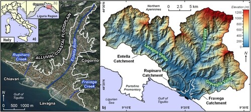
The plain is about 4.5 km in length and its width ranges from 350 m, in the inland sector, to 4 km, in the coastal strip. It is crossed by three watercourses: the Entella River, the major one, in the central sector, and the Rupinaro and Fravega Streams, at the western and eastern boundaries ((b)). The Entella River basin extends for 375 km2 and comprises the Lavagna (160 km2), Sturla (130 km2) and Graveglia (63 km2) tributaries (CitationRoccati, Faccini, Luino, Ciampalini, et al., 2019). The Rupinaro and Fravega catchments are smaller and they extend for 11.4 and 4.8 km2. However, in spite of their sizes, they have a considerable sediment transport due to the remarkable erosive processes that characterize the upper sectors of the basins, favoured by the high relief energy (CitationFaccini et al., 2013, Citation2015; CitationMetropolitan City of Genoa, 2018).
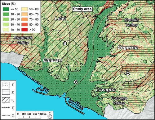
Except for small and narrow flat areas in the valley floors, steep slopes characterize the morphological setting of the region. Physical geographical sketches on the Main Map display slope values locally higher than 80% and altitude exceeding 1600 m along the Apennine range. Furthermore, this hilly and mountain region is characterized by a complex geological and tectonical setting with different types of rocks and multiple sets of discontinuities (CitationCimmino et al., 2004; Geological Service of Italy, Citation1968; CitationLiguria Region, 2005). As shown in the geology sketch map, the bedrock consists mainly of marl, silty marl, sandstone, shale and, secondarily, of ophiolite and chaotic complex. As documented for neighbouring areas (CitationBrandolini et al., 2017; CitationPepe, Mandarino, Raso, Scarpellini, et al., 2019), the inlands experienced an intense abandonment of cultivated terraced slopes mainly due to the socio-economic growth occurred over the last century (CitationBrandolini, 2017; CitationRoccati, Faccini, Luino, Turconi, & Guzzetti, 2018).
In the coastal sector of the Entella River basin, three main different morphological zones can be observed (CitationFaccini et al., 2012): (i) a hilly region with gentle slopes, made by shales in the western sector of Chiavari, (ii) a steeper hillslope environment made by slates and sandstone, in the eastern sector of the Lavagna and Cogorno and in the inland of Chiavari, and (iii) the flat area made up of fluvial and marine deposits that form the Entella floodplain and where the major urban centres stand (). In terms of land use, the plain is largely occupied by artificial areas, with small scattered patches of agricultural land interspersed within a discontinuous urban region along the Entella riversides in the inland, as shown in the land use sketch in the Main Map.
Figure 2. Morphological setting of the investigated floodplain and surrounding areas in comparison with geological features: (a) zone i; (b) zone ii; (c) zone iii. See the text for explanation. (1) Quaternary deposits; (2) Marl and silty marl; (3) Shale, shale with interlayered siltstone and limestone; (4) Divide defining the main contributing areas upstream of the floodplain; (5) Municipal boundary.
The Entella floodplain is characterized by a Mediterranean climate (CitationAlessandri et al., 2014; CitationRoccati, Faccini, Luino, Turconi, & Guzzetti, 2018; CitationSacchini et al., 2012) with dry and hot summers and mild winters. Rainfall is most abundant in autumn months with a mean annual rainfall of about 1130 mm (CitationARPAL-CMIRL, 2003-2010; CitationMinistero dei Lavori Pubblici, 1934–2003). The climate conditions of this Tyrrhenian sector are directly related to its orographic configuration that influences the atmospheric circulation and facilitates the formation of low-pressure systems that result in heavy rainfalls and floods (CitationAcquaotta et al., 2018, Citation2019; CitationPepe, Mandarino, Raso, Cevasco, et al., 2019). Because of the peculiar climate regime, the three main watercourses record the highest flows during prolonged or intense rainfalls in the autumn period. The minimum hydrometric levels are observed in summer or during protracted dry spells.
2.2. Human geography
The Entella floodplain is one of the largest urbanized coastal flat areas in Liguria ((a)) (CitationLuino et al., 2019). Urban areas occupy almost entirely the plain ((c)), with a continuous built-up area between the shoreline and the foothills (Chiavari and Lavagna) and along both the Entella riversides in the hinterland (Cogorno and Chiavari suburban districts). Some infrastructures cross the floodplain: Genoa-Rome railway and Aurelia road along the shoreline, and E80 motorway inland. Furthermore, many historical and modern bridges pass over the main watercourses. The tourist ports of Chiavari and Lavagna and the associated waterfronts dominate the coastline next to the mouth of the Entella River. The old town centres, developed on protohistoric settlements, have been gradually surrounded by new buildings over the time until to fill the coastal strip. Modern residential districts and productive sites occupy the inland sectors of the plain, along the riversides (CitationDe Negri, 1971; CitationDel Soldato, 1987; CitationRagazzi & Corallo, 1981; CitationRoccati, Faccini, Luino, Turconi, Piana, et al., 2018). Summing about 50,000 inhabitants, the urbanized Entella floodplain results extremely vulnerable and susceptible to high flood risk.
3. Material and methods
The geomorphological map of the Entella floodplain at 1:10,000 scale was derived by the analysis, reviewing, re-elaboration and summarization of previous geographical and geomorphological studies, papers and technical reports, land planning tools and historical documents (CitationBrandolini et al., 2005; CitationConti, 1951; CitationCorradi et al., 2003; CitationDe Negri, 1971; CitationDegli Espositi, 1991; CitationFaccini et al., 2005; CitationLagomaggiore, 1912; CitationLuino et al., 2016; CitationMetropolitan City of Genoa, 2018; CitationRoccati, Faccini, Luino, Turconi, Piana, et al., 2018; CitationRoccati, Faccini, Luino, Van De Graff, et al., 2019) A multi-temporal comparison of historical maps and photographs () was performed in a GIS to reconstruct the morphological modification of the plain over the centuries.
Table 1. Overview of the historical and recent maps used in the research.
Historical analysis allowed us to investigate the urban development of the floodplain and the evolution of the shoreline. The physio-geographical, geological and land use sketch maps were derived from regional cartography and are useful to describe the main features of the study area. Further maps in the paper show the urban evolution of the plain and the landforms that characterize the anthropogenic environment. Adopting the official guidelines recently published by Italian Institute for Environmental Protection and Research ISPRA (Citation2018), the main landforms, processes and deposits have been mapped. Based on the morphogenetic dynamics, we identified fluvial, coastal and anthropogenic elements, and distinguished them according to their state of activity. Geotechnical and stratigraphical information (e.g. thickness, size, age, etc.) were derived from bibliographic research, including results of field surveys and laboratory tests carried in the study area with different purposes. Classification of materials is based on the Unified Soil Classification System and British Soil Classification System classifications (CitationBell, 1998). Historical analysis of floods and sea storm surges that affected the Entella floodplain and the Tigullio Gulf since the seventeenth century completes the geomorphological investigation. Useful information have been collected from original contemporary documents kept in historical archives or reported in more recent works by other authors, newspaper articles and technical reports.
4. Geomorphology of the Entella floodplain
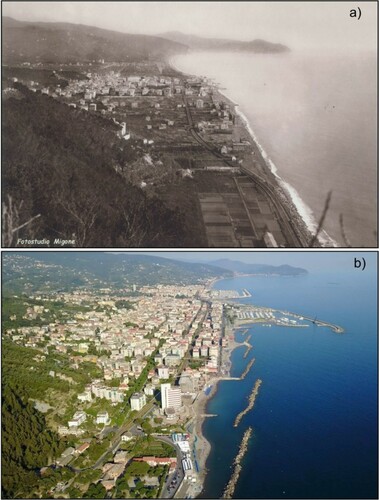
The map shows the morphology of the Entella River floodplain. Landforms have been distinguished according to morphogenetic landscapes into fluvial, coastal and anthropic. The plain resulted from the combination of natural processes, such as large floods, sea-level fluctuations, marine dynamics and climate conditions changes; and anthropic disturbances, including modification in river morphology, shoreline and land use because of the increasing urbanization. The combined and cyclical effects of fluvial and marine processes resulted in the gradual morphological evolution of the plain due to the deposition and redistribution of the alluvial and marine sediments. In the last two centuries, the floodplain has suffered remarkable and rapid modifications due to increasing human activity, particularly over the twentieth century. The natural landscape and geomorphological dynamics have been deeply influenced and evolved into an anthropogenic environment ().
Figure 3. The floodplain and shoreline modification over the last two centuries: (a) view of Chiavari and Lavagna in 1890 (‘E. Migone’, photographer archive in Chiavari); (b) recent view of the urbanized floodplain and modified shoreline (P. Giacomelli).
4.1. Fluvial landscape
4.1.1. Landforms and deposits
Fluvial processes originated erosion landforms and extended deposits distinguished based on their state of activity. Ancient and recent alluvial deposits largely occupy the plain along the Entella, Rupinaro and Fravega streams. Inactive deposits mainly consist of gravels, sands and silts, with significant fine materials, including clay, clayey silt and silty clay. They date back to the Holocene age and their thickness ranges from 10 to 30 m, locally up to 50 m. Fluvial materials are locally intercalated to marine deposits in the coastal strip or associated with clayey and inorganic soils typical of low-energy fluvial environments. For example, the ancient marshes formed by the Entella and Rupinaro floods in the depressed sectors of the plain and the paleochannels occupied by rivers during their migration in the plain which are mapped in the coastal sector of the plain. Recent deposits made by gravel, with subordinate sand, occupy the active riverbed of the main watercourses.
Among erosional landforms, scarps and fluvial terraces are mapped. Present-day terraced alluvial deposits originate the flat areas located along the rivers and become wider and wider going downstream, in the middle-lower sector. Approaching the mouth, ancient fluvial terraces represented by small residual lenses on a higher level compared to the actual valley floor can be also identified. Alluvial fans can be observed at the end of minor valleys in the central and southern sectors, partially or totally overlaid by urbanization.
4.1.2. Historical floods
Historical analysis reveals that the plain of Chiavari and Lavagna suffered frequently floods, some catastrophic, that caused damage and fatalities (CitationCasaretto, 2003; CitationRoccati, Faccini, Luino, Turconi, Piana, et al., 2018; CitationSanguineti, 1953). Since the seventeenth century, more than 50 floods have been recorded: the average time of recurrence of the floods in the final part of the Entella basin is less than 10 years (CitationRoccati, Faccini, Luino, Turconi, Piana, et al., 2018). Flooded areas are historically the flattest sectors of the coastal plain along the riverbeds in the hinterland and between the mouths of the watercourses (CitationBrandolini et al., 2008). Nowadays, these regions are intensely urbanized, greatly increasing the flood risk. The main floods of the Entella and Rupinaro rivers since the seventeenth century are listed in . In this table, we included both regular and flash floods originated by heavy rainfalls or intense rainstorms that affected the basins causing considerable socio-economical losses, including at least five fatalities ().
Figure 4. Historical and recent floods that affected the cities of Chiavari and Lavagna: (a,b) streets occupied by waters due to the Entella River flood on December 1910 (‘E. Migone’, photographer archive in Chiavari); (c) the east districts of Chiavari flooded by the Entella River on October 1953 causing one fatalities (Foto Web); (d) the flash flood of the Rupinaro Stream that caused one victim due the collapse of its bank on November 2002 (‘Il Secolo XIX’); (e) Lavagna and (f) Chiavari largely occupied by waters due to the synchronous flash flood of the Entella and Rupinaro rivers on November 2014 (‘Genova Today’).
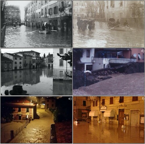
Table 2. Main flood events of the Entella River and Rupinaro Stream since the seventeenth century.
The oldest flood event occurred on 22 October 1626: it caused widespread damage to buildings, mills, bridges, harvests and cultivated fields throughout the Entella basin and the coastal plain, with 40 fatalities in the Graveglia valley (CitationCasaretto, 2003). The most recent inundations occurred on (i) 24 November 2002, when the flash flood of the Entella and Rupinaro caused damage to buildings, roads and industrial sites in large sectors of the plain and one victim in Chiavari (); (ii) 10 October 2013, when the flood wave of the Entella River caused two fatalities due to the collapse of a bridge in the inland of Chiavari (CitationFaccini, Piana, et al., 2017); and (iii) 10–11 November 2014, when the town of Chiavari was largely occupied by waters due to the synchronous flash flood of the Entella and Rupinaro rivers (CitationLuino & Turconi, 2017). During the last event, several damages to shops, basements, garages, roads and buildings in the old town and the urban districts of Chiavari were recorded. Riverbanks, industrial and commercial sites, leisure and tourist facilities along the Entella riversides in Chiavari, Lavagna and Cogorno municipalities were injured () (CitationFaccini et al., 2014, CitationFaccini, Giostrella, et al., 2017).
4.2. Coastal landscape
4.2.1. Landforms, deposits and shoreline processes
Mapped marine landforms include both the ancient deposits in the coastal strip of the plain and the present-day small and narrow beaches of Chiavari and Lavagna. They are made by sand and pebbles, locally interspersed with typically fluvial sediments in the inner sectors or material of anthropic origin along the shoreline. Sandy deposits form the large bar and submerge fan at the Entella River mouth. Historical analysis allowed to map the different position of shoreline over the last three centuries, from 1758 to present day. Before the construction of the two tourist ports close to the Entella River mouth, the original coastline was characterized by pebbly and sandy beaches due to the sediment supply by the watercourses, that favoured the shoreline advance, and the sea wave action and current drift effects that facilitated the erosion and redistribution of the alluvial deposits. Since the latter nineteenth century, the coastline underwent a regression because of human intervention. Channelization and quarrying from both the beaches and the riverbeds due to the increasing urbanization of the floodplain contributed to a reduction in sediment supply and the progressive and continuous retreat of the shoreline. The most significant modification occurred in the 1970s when the new sea promenade and the tourist ports of Chiavari and Lavagna were built close to the Entella River mouth. A new increase of the erosional processes took place: the new structures conveyed the small fluvial sediment supplies to the deeper seabed and interfered with the redistribution of the materials carried out by the current drift. The recent arrangement of the marina and the enlargement of the port of Chiavari further modified the shoreline. At the same time, the construction of coastal defence structures and the nourishment from land sources have been successful in partially reducing the coastal erosion.
4.2.2. Historical sea storm surge
Liguria frequently experiences destructive sea storm surges that cause damage to structures, infrastructures and erosional processes along the coast (). The most severe marine conditions result from the configurations of the most intense winds from SW (Libeccio) and SE (Scirocco) (CitationBrandolini et al., 2009; CitationGallino et al., 2012). Tigullio Gulf underwent several sea storm surges in the last centuries. Due to its orographic configuration, the central and eastern sectors suffered historically the most destructive storms when winds moved up to the Ligurian Sea with the maximum extent of the fetch and an SW–NE orientation (Libeccio), whereas the most damaging in the western sectors resulted from a dominant configuration of winds from S-SE (Scirocco).
Figure 5 Historical and recent sea storms that affected the shoreline of the Entella floodplain: (a) Chiavari, 1906 (‘E. Migone’, photographer archive in Chiavari); (b) Chiavari, 1955 (‘Museo Marinaro Tommasino-Andreatta’, Chiavari); (c,d) Lavagna, December 1976-January 1977 (‘Tigullio News’); (e) Lavagna, November 2011 (‘Il Secolo XIX’); (f) Chiavari, October 2018 (YouTube).
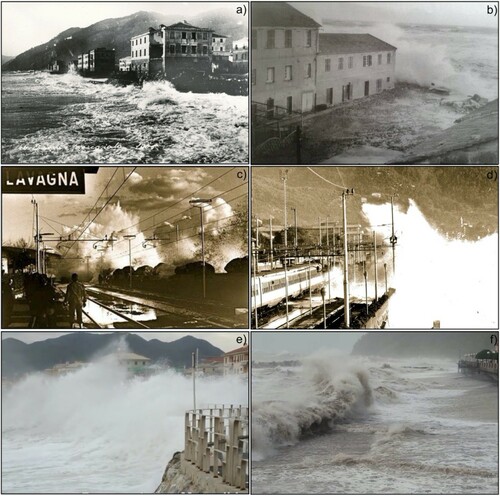
The main sea storm surges that affected the Tigullio Gulf over the last centuries are listed in .
Table 3. Main sea storm events in the Tigullio Gulf since the seventeenth century.
In particular, between 1976 and 1977, the coastal sector of Lavagna was repeatedly hit by very intense gales of Libeccio that resulted in three sea storm surges (CitationGallino et al., 2012). The first occurred on 7–8 November 1976 causing erosive processes that destroyed a large portion of the beaches, several bathing facilities and damaged the retaining wall of the sea promenade. The second and most destructive event occurred on 2–3 December 1976, when the retained wall was destroyed and the railway embankment along the shoreline damaged (). The third and last storm sea occurred on 10–13 January 1977: the railway was destroyed, the rails were bent and the main road Aurelia was closed. On 6 November 2000, the combined effects of Scirocco and Libeccio resulted in a storm surge that caused damage particularly in the sector of the Gulf exposed to the SE winds (CitationGallino et al., 2012). In Rapallo the promenade and part of the old town were flooded by the sea and many boats sank. The most recent sea storm event occurred on 29 October 2018, when a low-pressure formation moved to the Ligurian Sea caused a surge from SE, then from S and SW on the decrease (CitationARPAL-CMIRL, 2018). The tourist port of Rapallo was totally destroyed, several boats sank, the sea promenade and many bathing facilities seriously damaged. The road leading from Santa Margherita to Portofino, which develops along the coast a few metres from the sea, was interrupted by the removal of a long stretch of road embankment.
4.3. Anthropogenic landscape
4.3.1. Landforms and deposits
Mapped anthropogenic landforms include interventions along watercourses and shoreline, fillings and embankments. Continuous riverbank protections characterize large stretches of the Entella, Rupinaro and Fravega channelized riverbeds, particularly within the densely urbanized area of Chiavari and Lavagna. Furthermore, the Fravega Stream is culverted before the coastline. Ancient minor channels which drained the surplus of water from marshlands to the Entella River or direct to the sea have been totally culverted and integrated into the urban water mains. Moreover, new artificial channels have been created in the hinterland to convey rain and running waters direct to the Entella River ().
Figure 6. Anthropogenic landforms sketch map.
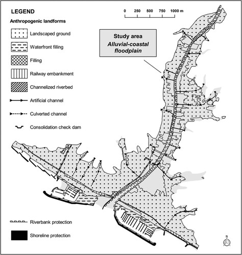
New artificial areas have been created in place of beaches and natural spaces along the coast. They include sea embankments and fillings required for the construction of the tourist ports and the associate waterfronts, as well as shoreline protections including groynes, breakwaters and submerged seawalls that have greatly modified its morphology and dynamics (). Artificial landforms include also the railway embankment and urban road network fillings. Nowadays, urban areas occupy large sectors of the Entella floodplain, as shown in the land use sketch map. The natural landscape has been greatly modified by human activities over the last two centuries and particularly since the 1950s because of the population increase and the rapid and massive urban sprawl. Several anthropogenic disturbances affected riverbeds and shoreline (). On the one hand, modifications were caused by land demands for urban development; on the other hand, they resulted in further changes in land use and into a reduction of the channel’s hydraulic efficiency. This condition is in agreement with the trend observed in most of the Italian rivers (CitationCencetti et al., 2017; CitationMandarino et al., 2019a; CitationScorpio et al., 2015; CitationSurian et al., 2009): main modification in fluvial morphology include channelization, narrowing, straightening and displacement of the main watercourses (CitationLuino et al., 2019; CitationRoccati, Faccini, Luino, Van De Graff, et al., 2019). Furthermore, the construction of bridges and new roads, buildings and warehouses close to the riversides obliterated the ancient large riverbeds and the natural ancient perifluvial areas historically occupied by waters during the flood events, as observed in other Italian rivers (CitationMandarino et al., 2019b).
4.3.2. Urban evolution of the plain
The ancient settlement of Chiavari was built in the pre-Roman period at the foot of the hills between the Entella and Rupinaro riverbeds, as proved by the archaeological findings and the historical researches (CitationDel Soldato, 1987). The foundation of Lavagna occurred later in the Roman period, when a village was built in the foothills close to the Fravega Stream. During the Middle Ages, the settlement of Chiavari slowly developed: in the eighteenth century the built-up area extended from the foothills to the coastal strip occupied by market gardens. At the same time, the village of Lavagna settled along the ancient Aurelia roman road. The floodplain was still largely occupied by agricultural or natural land, whereas the marshland formed by the floods of the three main watercourses lay at the mouths (CitationDel Soldato, 1987; CitationLagomaggiore, 1912). The urban development of Chiavari and Lavagna was moderate during the nineteenth century. A limited and discontinuous expansion involved the western riverside of the Entella River and the coastal strip, where the railway was constructed between 1868 and 1870. Since the earlier twentieth century, the floodplain underwent a rapid urban sprawl (CitationRoccati, Faccini, Luino, Turconi, Piana, et al., 2018) (): new buildings, roads, bridges and facilities gradually replaced many cultivated and vegetated areas. Entirely new exclusive neighbourhoods were built in Chiavari between the old town and the railway and, secondarily, in Lavagna between the ancient settlement and the Entella riverbed. The new urban areas were built for the early tourism development and the wealthy people who returned from North and South America, where they had migrated to seek fortunes at the end of the nineteenth century.
Figure 7. Urban evolution map of Chiavari, Lavagna and Cogorno from 1758 to 2018. (Modified from CitationRoccati, Faccini, Luino, Turconi, Piana, et al. (2018)).
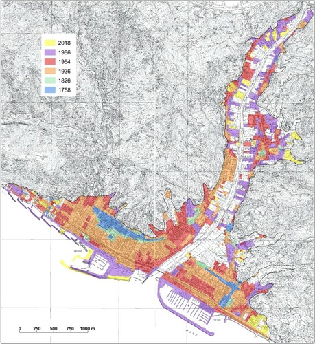
However, the most important transformation occurred between the 1950s and the 1980s, with the post-war population increase bringing economic and welfare growth caused an urban sprawl in Chiavari, Lavagna and Cogorno. The coastal sector of the floodplain, from the shoreline up to the foothills, was urbanized and almost entirely filled by residential, tourist and economic developments. Although urbanization carried on in the hinterland and in the hilly country, the morphological setting of the plain and its landscape remained almost unchanged over the last decade of the twentieth century and in the early 2000s.
5. Conclusions
Geomorphological analysis of the Entella floodplain allowed to recognize and mapping: (i) fluvial landforms and processes, (ii) coastal landforms and dynamics, including the representation of the shoreline evolution over more than 200 years, and (iii) anthropic landforms, which dominate the current landscape and which also include modified natural landforms.
The research highlights that landforms and surface processes in the urban landscape are difficult to analyse and identify due to its great variability in both chemical–physical features and spatial distribution. Moreover, mapping is made more difficult by the overlap of the different stages of urbanization that have partially or totally obliterated the former natural structures and generated man-made features. Further investigations may provide useful information to characterize anthropogenic landforms, including geotechnical surveys, drillings and wells, more detailed models of the topographic surface and reliable terrain models.
The impact of human activities on geomorphological processes, such as fluvial and coastal floods, greatly increased their associated risks, because of the amplified exposure to such hazardous dynamics. In urban areas such as Chiavari and Lavagna, geo-hydrological risks are related to the urban sprawl in a historically fragile territory. Vulnerability is therefore correlated to the inappropriate river and coastal management and uncontrolled urbanization, which caused modifications in fluvial and marine dynamics, soil sealing and reduced or totally obliterated the natural spaces where the geomorphological dynamics take place. Furthermore, risks are amplified by the effects of climate change that likely increase the scale and frequency of extreme events (CitationBarreda-Escoda & Llasat, 2015; CitationBlöschl et al., 2007; CitationFeyen et al., 2009).
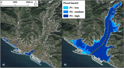
To map natural and anthropogenic landforms and processes and their interactions must become a mandatory analysis, particularly for the risk assessment and management in urban and land planning ().
Figure 8. Maps of the urban areas exposed to (a) coastal flood and (b) flood hazard from according to the EU directive 2007/60/CE on the assessment and management of flood risk (CitationLigurian Region, 2014, Citation2015).
In conclusion, geomorphological mapping is essential to understand the geomorphological processes that historically characterize urban areas. Climate change in the Mediterranean area will entail as an increase in air temperature and change in rainfall regime, with an increase in the intensity of the rainfall: so geomorphological mapping must represent a useful tool to support a correct and sustainable urban planning and fluvial and coastal management in terms of risk assessment and mitigation.
Software
The data digitizing and the map design were completely performed by means of Quantum GIS 2.18. In addition, Corel Draw 13.0 was used for preparing figures.
Supplemental Material
Download PDF (68.7 MB)Disclosure statement
No potential conflict of interest was reported by the author(s).
Related Research Data
References
- Acquaotta, F., Faccini, F., Fratianni, S., Paliaga, G., & Sacchini, A. (2018). Rainfall intensity in the Genoa Metropolitan area (Northern Mediterranean): Secular variations and consequences. Weather, 73(11), 356–362. https://doi.org/10.1002/wea.3208.
- Acquaotta, F., Faccini, F., Fratianni, S., Paliaga, G., Sacchini, A., & Vilìmek, V. (2019). Increased flash flooding in Genoa Metropolitan area: A combination of climate changes and soil consumption? Meteorology and Atmospheric Physics, 131(4), 1099–1110. https://doi.org/10.1007/s00703-018-0623-4.
- Agenzia Regionale per la Protezione dell’Ambiente Ligure-Centro Funzionale Meteo-Idrologico di Protezione Civile della Regione Liguria. (2003–2010). Annali idrologici [Hydrological Report]. Retrieved 23 October 23, 2019, from https://www.arpal.gov.it/homepage/meteo/pubblicazioni/annali-idrologici.html
- Agenzia Regionale per la Protezione dell’Ambiente Ligure-Centro Funzionale Meteo-Idrologico di Protezione Civile della Regione Liguria. (2018). Rapporto di Evento Meteorologico del 27-30 Ottobre 2018 [Report on the 27–30 October 2018 meteo-hydrological event]. Retrieved October 23, 2019, from https://www.arpal.gov.it/contenuti_statici//pubblicazioni/rapporti_eventi/2018/REM_20181027-30_rossaBCDE_vers20190107.pdf
- Alessandri, A., De Felice, M., Zeng, N., Mariotti, A., Pan, Y., Cherchi, A., Lee, J. Y., Wang, B., Ha, K. J., Ruti, P., & Artale, V. (2014). Robust assessment of the expansion and retreat of Mediterranean climate in the 21st century. Scientific Reports, 4(1), Article 7211. https://doi.org/10.1038/srep07211.
- Barreda-Escoda, A., & Llasat, M. C. (2015). The role of climatic factors in evolving flood patterns in Mediterranean region (1301-2012). Hydrology and Earth System Sciences, 19, 465–483. https://doi.org/10.5194/hess-1-465-2015 doi: 10.5194/hess-19-465-2015
- Bathrellos, G. D. (2007). An overview in urban geology and urban geomorphology. Bulletin of the Geological Society of Greece, 40(3), 1354–1364. https://doi.org/10.12681/bgsg.16888.
- Bell, F. (1998). Environmental geology principles and practice. Blackwell Science Ltd. 594 pp.
- Blöschl, G., Ardoin-Bardin, S., Bonell, M., Dorninger, M., Goodrich, D., Gutknecht, D., Matamoros, D., Merz, B., Shand, P., & Szolgay, J. (2007). At what scales do climate variability and land cover change impact on flooding and low flows? Hydrological Processes, 21, 1241–1247. https://doi.org/10.1002/hyp.6669.
- Brandolini, P. (2017). The outstanding terraced landscape of the Cinque Terre coastal slopes (Eastern Liguria). In M. Soldati & M. Marchetti (Eds.), Landscapes and landforms of Italy, World geomorphological landscapes (pp. 235–244). Springer International Publishing.
- Brandolini, P., Canepa, G., Faccini, F., Robbiano, A., & Terranova, R. (2007). Geomorphological and geo-environmental features of the Graveglia valley (Ligurian Apennines). Geografia Fisica e Dinamica Quaternaria, 30, 99–116.
- Brandolini, P., Cappadonia, C., Luberti, G. M., Donadio, C., Stamatopoulos, L., Di Maggio, C., Faccini, F., Stanislao, C., Vergari, F., Paliaga, G., Agnesi, V., Alevizos, G., & Del Monte, M. (2019). Geomorphology of the Anthropocene in Mediterranean urban areas. Progress in Physical Geography, 1–34. https://doi.org/10.1177/0309133319881108.
- Brandolini, P., Faccini, F., Nicchia, P., & Terranova, R. (2005). Dissesti geomorfologici, eventi alluvionali ed insediamenti antropici: Il caso di Tribogna in Val Fontanabuona (Appennino ligure) [Geomorphological instability, floods and communities: The case of Tribogna in Fontanabuona valley (Ligurian Apennines)]. Geografia Fisica e Dinamica Quaternaria (Suppl. VII), 69–77.
- Brandolini, P., Faccini, F., Paliaga, G., & Piana, P. (2017). Urban geomorphology in coastal environment: Man made morphological changes in a seaside tourist resort (Rapallo, Eastern Liguria, Italy). Quaestiones Geographicae, 36(3), 73–87. https://doi.org/10.1515/quageo-2017-0027.
- Brandolini, P., Faccini, F., Paliaga, G., & Piana, P. (2018). Man-made landforms survey and mapping of an urban historical centre in a coastal Mediterranean environment. Geografia Fisica e Dinamica Quaternaria, 41, 23–34. https://doi.org/10.4461/GFDQ%202017.40.8.
- Brandolini, P., Faccini, F., Robbiano, A., & Terranova, R. (2008). Relationship between flood hazards and geomorphology applied to land planning in the upper Aveto valley (Liguria, Italy). Geografia Fisica e Dinamica Quaternaria, 31, 73–82.
- Brandolini, P., Faccini, F., Robbiano, A., & Terranova, R. (2009). Slope instability on rocky coast: A case study of Le Grazie landslides (Eastern Liguria, northern Italy). The Geological Society, 322, 143–154. https://doi.org/10.1144/SP322.6
- Brown, A. G., Tooth, S., Bullard, J. E., Thomas, D. S. G., Chiverrell, R. C., Plater, A. J., Murton, J., Thorndycraft, V. R., Tarolli, P., Rose, J., Wainwright, J., Downs, P., & Aalto, R. (2017). The geomorphology of the Anthropocene: Emergence, status and implications. Earth Surface Processes and Landforms, 42(1), 71–90. https://doi.org/10.1002/esp.3943.
- Burak, S., Dogˇan, E., & Gaziogˇlu, C. (2004). Impact of urbanization and tourism on coastal environment. Ocean & Coastal Management, 47(9–10), 515–527. https://doi.org/10.1016/j.ocecoaman.2004.07.007.
- Casaretto, F. (2003). Inondazioni a Chiavari dal 1626 al 1950 [Floods in Chiavari from 1626 to 1950]. Monografia. Biblioteca Società Economica, 8 pp.
- Cencetti, C., De Rosa, P., & Fredduzzi, A. (2017). Geoinformatics in morphological study of River Paglia, Tiber River basin. Central Italy. Environmental Earth Sciences, 76, 128. https://doi.org/10.1007/s12665-017-6448-5.
- Chegtai, D. (1995). An approach to theory and methods of urban geomorphology. Chinese Geographical Science, 6(1), 88–95. https://doi.org/10.1007/s11769-996-0039-9.
- Cimmino, F., Faccini, F., & Robbiano, A. (2004). Stones and coloured marbles of Liguria in historical monuments [Special Issue 3: A showcase of the Italian research in applied petrology]. Per. Mineral., 73, 71–84.
- Conti, S. (1951). Sulle cause determinanti l’arretramento della spiaggia di Chiavari, Lavagna e Cavi [About the shoreline regression in Chiavari, Lavagna and Cavi]. Annali di Ricerche e Studi di Geografia. Istituto di Geografia dell’Università di Genova.
- Cooke, R. U. (1976). Urban geomorphology. Geographical Journal, 142, 59–65. https://doi.org/10.2307/1796025
- Corradi, N., Delbono, I., Barsanti, M., & Ferretti, O. (2003). Caratteri morfologici, sedimentologici ed evoluzione del litorale compreso tra Chiavari e Sestri Levante (Liguria Orientale) [morphological and sedimentological aspects and evolution of the shoreline between Chiavari and Sestri Levante, Eastern Liguria]. In O. Ferretti (Ed.), Studi per la creazione di strumenti di gestione costiera, Golfo del Tigullio (pp. 21–39). ENEA, Centro Ricerche Ambiente Marino. https://doi.org/10.13140/2.1.2513.1528. Retrieved October 1, 2019, from www.santateresa.enea.it/wwwste/dincost/dincost2.html.
- Crutzen, P. J. (2002). Geology of mankind. Nature, 415, 23. https://doi.org/10.1038/415023a.
- De Negri, C. (1971). La foce dell’Entella. Note di geografia storica [The mouth of the Entella River. Historical-geographical notes]. In Fratelli, Bozzi (Ed.) Miscellanea di Geografia Storica e Storia della Geografia (pp. 21–32).
- Degli Espositi, R. (1991). Il fiume Entella [The Entella River]. In Chiavari: Vicende del territorio, delle istituzioni e degli abitanti (pp. 17–23). Rotary Club Rapallo Tigullio (Ed.). (In Italian).
- Del Soldato, M. (1987). L’evoluzione della piana alluvionale del Rupinaro in epoca protostorica e storica [Evolution of the floodplain of the Rupinaro Stream in protohistoric and historic age]. Studi Genuensi, 6, 19–45. (In Italian).
- Eeyles, N. (1997). Environmental geology of urban areas. Geotext, 3. Geological Association of Canada. 590 pp.
- Ellison, R. A., Booth, S. L., & Strange, P. J. (1993). Geological mapping in urban areas. Episodes, 16(3), 383–338. https://doi.org/10.18814/epiiugs/1993/v16i3/003
- Faccini, F., Brandolini, P., Robbiano, A., Perasso, L., & Sola, A. (2005). Fenomeni di dissesto e precipitazioni in rapporto alla pianificazione territoriale: L’evento alluvionale del novembre 2002 nella bassa Val Lavagna (Liguria Orientale) [Instability processes and rainfalls with reference to land-planning: The flood event on November 2002 in the lower Lavagna Valley, Eastern Liguria]. Geografia Fisica e Dinamica Quaternaria (Suppl. VII), 145–153. (In Italian).
- Faccini, F., Giostrella, P., Lazzeri, R., Melillo, M., Raso, M., & Roccati, A. (2014). The 10th November 2014 flash-flood event in Chiavari City (Eastern Liguria, Italy). Rendiconti Online Della Società Geologica Italiana, 35, 124–127. https://doi.org/10.3301/rol.2015.80.
- Faccini, F., Giostrella, P., Melillo, M., Sacchini, A., & Santangelo, M. (2017). Heavy rains triggering flash floods in urban environment: A case from Chiavari (Genoa Metropolitan area, Italy) [Special Issue]. Italian Journal of Engineering Geology and Environment, 1, 51–66. https://doi.org/10.4408/IJEGE.2017-01.S-05.
- Faccini, F., Lazzeri, R., Robbiano, A. (2015). Engineering geological and Hydrogeological Characterization of Acero Landslide (upper Sturla valley, Northern Apennine). In G. Lollino (Ed.), Engineering geology for Society and territory (Vol. 2, pp. 1033–1036). Springer International Publishing.
- Faccini, F., Piana, P., Sacchini, A., Lazzeri, R., Paliaga, G., & Luino, F. (2017). Assessment of heavy rainfall triggered flash floods and landslides in the Sturla stream basin (Ligurian Apennines, Northwestern Italy). Jokull, 67, 44–74.
- Faccini, F., Robbiano, A., Roccati, A., & Angelini, S. (2012). Engineering geological map of the Chiavari city area (Liguria, Italy). Journal of Maps, 8, 41–47. https://doi.org/10.1080/17445647.2012.668756.
- Faccini, F., Robbiano, A., Roccati, A., & Raso, E. (2013). Gravity-driven deep-reaching deformations and large-scale landslides in recently uplifted mountain areas: The case-study of Mt. Cucco and Belpiano (Ligurian Apennine, Italy). Italian Journal of Engineering Geology and Environment – Book Series, 6, 141–152. https://doi.org/10.4408/IJEGE.2013-06.B-11
- Feyen, L., Barredo, J. I., & Dankers, R. (2009). Implications of global warming and urban land use change on flooding in Europe. In J. Feyen, K. Shannon, & M. Neville (Eds.), Water and urban development Paradigms: Towards an Integration of Engineering, design and management Approaches (pp. 217–225). Taylor and Francis.
- Gallino, S., Benedetti, A., & Onorato, L. (2012). Wave watching. Lo spettacolo delle mareggiate in Liguria (Ulrico Hoepli, Ed.), 224 pp. ISBN: 9788820375195
- Geological Service of Italy – Servizio Geologico d’Italia (1968). Geological map of Italy at 1:100,000 scale. Foglio 83 “Rapallo” (2nd ed.).
- Griffiths, S., Smith, M. J., & Paron, P. (2011). Introduction to applied geomorphological mapping. Developments and Earth Surface Processess, 15, 3–11. https://doi.org/10.1016/B978-0-444-53446-0.00001-X.
- Italian Institute for Environmental Protection and Research ISPRA, Italy Geological Survey. (2018). Carta Geomorfologica d’Italia (1:50,000) – Aggiornamento e integrazioni delle linee guida della carta Geomorfologica d’Italia alla scala 1:50,000 (Fascicolo I). In C. Campobasso (Ed.), Progetto CARG: Modifiche e integrazioni al Quaderno 4/1994. Quaderni serie III (Vol. 13, pp. 95). Servizio Geologico Nazionale. (In Italian).
- Lagomaggiore, C. (1912). Il problema del fiume Entella e della spiaggia di Chiavari-Lavagna [about the Entella River and the shore of Chiavari and Lavagna]. In Tipografia Esposito (Ed.), Vita Chiavarese (pp. 1–64). (In Italian).
- Lee, E. M. (2001). Geomorphological mapping. In J. S. Griffiths (Ed.), Land surface Evaluation for Engineering Practice. Engineering geology Special Publications (Vol. 18, pp. 53–56). Geological Society. https://doi.org/10.1144/GSL.ENG.2001.018.01.08.
- Liguria Region. (2005). Regional Geological Map at 1:5,000 scale. Tav. 231.1, 231.4 Chiavari-Recco. Retrieved October 23, 2019, from http://www.cartografia.regione.liguria.it
- Ligurian Region. (2014). Direttiva Alluvioni 2007/60/CE – Scenari di pericolosità da inondazioni marine [The EU Flood Directive 2007/60 – coastal flooding risk scenarios]. Retrieved October 23, 2019, from www.ambienteinliguria.it
- Ligurian Region. (2015). Direttiva Alluvioni 2007/60/CE – Scenari di pericolosità alluvionale [The EU Flood Directive 2007/60 – flood risk scenarios]. Retrieved October 23, 2019, from www.ambienteinliguria.it
- Luino, F., Nigrelli, G., Turconi, L., Faccini, F., Agnese, C., & Casillo, F. (2016). A proper land-use planning through the use of historical research. Disaster Advances, 9(1), 8–19.
- Luino, F., Paliaga, G., Roccati, A., Sacchini, A., Turconi, L., & Faccini, F. (2019). Anthropogenic changes in the alluvial plains of the Tyrrhenian Ligurian basins. Rendiconti Online Della Società Geologica Italiana, 48, 10–16. https://doi.org/10.3301/ROL.2019.31.
- Luino, F., & Turconi, L. (2017). Eventi di piena e frana in Italia Settentrionale nel periodo 2005-2016 [Flood and landslide events in Northern Italy over the 2005-2016 period] (pp. 1–478 ). SMS (Ed.) (In Italian). Regione Lombardia.
- Mandarino, A., Maerker, M., & Firpo, M. (2019). Channel planform changes along the Scrivia River floodplain reach in northwest Italy from 1878 to 2016. Quaternary Research, 91(2), 620–637. https://doi.org/10.1017/qua.2018.67.
- Mandarino, A., Maerker, M., & Firpo, M. (2019). ‘The stolen space’: A history of channelization, reduction of riverine areas and related management issues. The lower Scrivia river case study (NW Italy). International Journal of Sustainable Development and Planning, 14(2), 118–129. https://doi.org/10.2495/SDP-V14-N2-118-129.
- Metropolitan City of Genoa. (2018). Ambito Regionale di Bacino 16. Piano di Bacino Stralcio per la tutela del rischio idrogeologico [Master plan for the protection against geo-hydrological risk. Regional basin area n. 16]. Retrieved January 13, 2020 from http://www.pianidibacino.ambienteinliguria.it/GE/ambito16/documenti/GE_Amb16_RelGen_rev08.pdf
- Ministero dei Lavori Pubblici. (1934–2003). Annali Idrologici [Hydrological Report]. Ministero dei Lavori Pubblici, Servizio Idrografico. Retrieved October 23, 2019, from http://www.acq.isprambiente.it/annalipdf/
- Ministero di Agricoltura, Industria e Commercio. (1877). Tavole di Ragguaglio dei pesi e delle Misure già in uso nelle varie Province del Regno col Sistema Metrico Decimale [Table of measurement of weights already in use in the various provinces of the kingdom with the decimale metric system]. Stamperia Reale.
- Paliaga, G., Faccini, F., Luino, F., & Turconi, L. (2018). A spatial multicriteria prioritizing approach for geohydrological risk mitigation planning in small and densely urbanized Mediterranean basins. Natural Hazards and Earth System Sciences, 19, 53–69. https://doi.org/10.5194/nhess-2018-100 doi: 10.5194/nhess-19-53-2019
- Pepe, G., Mandarino, A., Raso, E., Cevasco, A., Firpo, M., & Casagli, N. (2019). Extreme flood and landslides triggered in the Arroscia valley (Liguria Region, Northwestern Italy) during the November 2016 rainfall event. In A. Shakoor & K. Kato (Eds.), Slope stability: Case histories, landslide mapping, emerging technologies, Proceedings of the IAEG/AEG annual Meeting (Vol. 1, pp. 171–175). Springer International Publishing.
- Pepe, G., Mandarino, A., Raso, E., Scarpellini, P., Brandolini, P., & Cevasco, A. (2019). Investigation on farmland abandonment of terraced slopes using multitemporal data sources comparison and its implication on hydro-geomorphological processes. Water, 11, 1552. https://doi.org/10.3390/w11081552.
- Ragazzi, F., & Corallo, C. (1981). Chiavari: Sagep (Ed.). (In Italian). ISBN-10: 8870580261. (In Italian).
- Roccati, A., Faccini, F., Luino, F., Ciampalini, A., & Turconi, L. (2019). Heavy rainfall triggering shallow landslides: A susceptibility assessment by a GIS-approach in a Ligurian Apennine Catchment (Italy). Water, 11, 605. https://doi.org/10.3390/w11030605.
- Roccati, A., Faccini, F., Luino, F., Turconi, L., & Guzzetti, F. (2018). Rainfall events with shallow landslides in the Entella catchment (Liguria, Northern Italy). Natural Hazards and Earth System Sciences, 18, 2367–2386. https://doi.org/10.5194/nhess-18-2367-2018.
- Roccati, A., Faccini, F., Luino, F., Turconi, L., Piana, P., & Watkins, C. (2018). Historical geomorphological research of a Ligurian coastal floodplain (Italy) and its value for management of flood risk and environmental sustainability. Sustainability, 10, 3727. https://doi.org/10.3390/su10103727.
- Roccati, A., Faccini, F., Luino, F., Van De Graff, J., & Turconi, L. (2019). Morphological changes and human impact in the Entella River floodplain (Northern Italy) from the 17th century. Catena, 182, Article 104122. https://doi.org/10.1016/j.catena.2019.104122.
- Sacchini, A., Ferraris, F., Faccini, F., & Firpo, M. (2012). Environmental climatic maps of Liguria. Journal of Maps, 8, 199–207. https://doi.org/10.1080/17445647.2012.703901.
- Sanguineti, G. (1953). Le alluvioni nel Chiavarese e riassunto meteorologico per l'anno 1953 [Flood event in Chiavari and its neighbouring and the 1953 annual meteorological report]. Tipografia Esposito. (In Italian).
- Scorpio, V., Aucelli, P. P., Giano, S. I., Pisano, L., Robustelli, G., Rosskopf, C. M., & Schiattarella, M. (2015). River channel adjustments in southern Italy over the past 150 years and implications for channel recovery. Geomorphology, 251, 77–90. https://doi.org/10.1016/j.geomorph.2015.07.008.
- Surian, N., Rinaldi, M., Pellegrini, L., Audisio, C., Maraga, F., Teruggi, L., Turitto, O., & Ziliani, L. (2009). Channel adjustments in northern and central Italy over the last 200 years. In L. A. James, S. L. Rathburn, & G. R. Whittecar (Eds.), Management and restoration of fluvial systems with broad historical changes and human impacts (Vol. 451, pp. 83–95). Geological Society of America. https://doi.org/10.1130/2009.2451(05).
- Tarolli, P., & Sofia, G. (2016). Human topographic signatures and derived geomorphic processes across landscapes. Geomorphology, 255, 140–161. https://doi.org/10.1016/j.geomorph.2015.12.007.
- Thornbush, M. J. (2015). Geography, urban geomorphology and sustainability. Area, 47, 350–353. https://doi.org/10.1111/area.12218.
- Thornbush, M. J., & Allen, C. D. (2018). Urban geomorphology: Landforms and processes in cities (pp. 1–349). Elsevier.
- Waters, C. N., Zalasiewicz, J. A., Summerhayes, C., Barnosky, A. D., Poirier, C., Gałuszka, A., Cearreta, A., Edgeworth, M., Ellis, E. C., Ellis, M., Jeandel, C., Leinfelder, R., McNeill, J. R., deB, R. D., Steffen, W., Syvitski, J., Vidas, D., Wagreich, M., Williams, M., … Wolfe, A. (2016). The Anthropocene is functionally and stratigraphically distinct from the Holocene. Science, 351, Article aad2622. https://doi.org/10.1126/science.aad2622.