
ABSTRACT
The paper describes the multitemporal landslide inventory map prepared for the urban areas of Motta Montecorvino and Volturino, two municipalities located in the Southern Apennines (Apulia Region, Italy). These territories show a high propensity to landslides of different types and magnitude, which periodically interfere with the anthropic structures and infrastructures. For the study area, the spatial and temporal distribution of landslides is detected for the period between 1954 and 2003, through the visual interpretation of multiple sets of black and white digital stereoscopic aerial photographs at different scales. The analysis reveals locally high frequency of landslide occurrence and built-up areas on existing landslides, either on the body or on the crown areas. In particular, we show that over the years new residential areas were developed despite the presence of large old mass movements.
1. Introduction
Landslides are one of the most widespread types of natural hazard in the Apennine Mountains and their consequences on structures and infrastructures are largely acknowledged by the Italian scientific community. The Daunia Apennines, which is located in the north-western area of the Apulia region, are known to be intensely and continuously affected by landslides of different types, which occurrence periodically interferes with the anthropic structures and infrastructures (CitationCotecchia et al., 2016). This sector of the Apulia region is mainly characterized by slow moving deep-seated phenomena that can show seasonal accelerations, in the late winter-mid spring, when highest piezometric levels are registered (CitationCotecchia et al., 2011; CitationWasowski et al., 2012), causing significant damage to buildings and infrastructure () (CitationCrescenzi et al., 1994). Moreover, shallow slope failures, mainly triggered by rainfall events (CitationCotecchia et al., 2015; CitationParise et al., 2012; CitationWasowski et al., 2010; Citation2012), are registered in the area as partial reactivations of the larger and deeper phenomena.
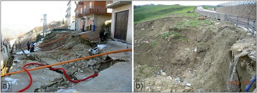
Figure 1. Examples of infrastructures damaged by landslides in the urban area of Volturino (a) and Motta Montecorvino (b).
In the literature, several articles describe the landslide activity of the Daunia Apennines, as for example the reactivation of an old landslide in the Volturino municipality in March 2015 (CitationLollino et al., 2016), or in the Bovino municipality where an old mass movement, the so-called Pianello landslide, exhibited partial reactivations or semi-continuous extremely slow movements during the last few decades (CitationCotecchia et al., 2016; CitationDel Gaudio et al., 2003; CitationWasowski & Pisano, 2020). For the Daunia Apennines, given the complexity and the incidence of the landslides, several inventory maps have been compiled for the entire region (CitationTrigila, 2007; CitationZezza et al., 1994), or for part of it (CitationIovine et al., 1996; CitationMossa et al., 2005; CitationPellicani & Spilotro, 2015; CitationWasowski et al., 2010).
The interaction between urban settlements and landslides is relevant since it determines direct and indirect losses that affect the economy and the development of the study area (CitationPisano et al., 2016). Some studies (e.g. CitationWasowski et al., 2007; Citation2010) suggested the worsening of the stability conditions of the slopes bordering the hilltop towns of the Daunia Apennines in the last few decades. This trend was related to the contemporaneous residential development and the infrastructure growth. Multi-temporal interferometry investigations have highlighted the reactivations of pre-existing landslides (or portions of them), as indicated by the analysis carried out in Volturino (CitationBovenga et al., 2006), Motta Montecorvino (CitationWasowski et al., 2008), and other cases reported in CitationWasowski and Bovenga (2015) and CitationWasowski and Pisano (2020).
Complete and reliable landslide inventory maps, (i.e. geomorphological, multi-temporal or event inventory), showing the spatial and temporal distribution of mass movements, are essential tools to understand the geomorphological evolution of the territory, and the main source of information for landslides hazard and risk assessment (CitationArdizzone et al., 2012; CitationSantangelo et al., 2015).
In this article, we present a multi-temporal landslide inventory map to investigate the spatial and temporal interaction between landslides and urban areas. The work is carried out in Motta Montecorvino and Volturino, two small municipalities in the northern part of the Apulia region. The study area is representative of the settlements of the Daunia Apennines, with the towns’ historical centers occupying the hilltops (CitationZezza et al., 1994) and the recent urban developments located along the slopes descending towards the valleys. For the 2 municipalities, a period of 50 years is analyzed (1954–2003) through the interpretation of multiple sets of aerial photographs.
2. Environmental setting
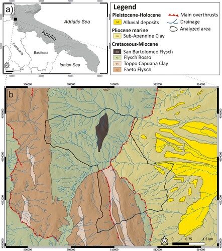
The Daunia region, in the Southern Apennines, are located in the northern-western part of the Apulia Region, at the border with Molise region on the North and Campania on the West (). The relief ranges from 100 m a.s.l., to the highest peak represented by Monte Cornacchia, reaching 1152 m a.s.l. The Daunia can be structurally divided in two main sectors: the western, belonging to the external front of the southern Apennine chain, constitutes the hilly mountains terrains, while the eastern constitutes the piedmont of the Tavoliere Plain, which is the foredeep extending eastwards the Adriatic Sea (CitationDel Gaudio et al., 2012). The western part has higher local relief characterized by a complex geological structure with clay-rich flysch lithologies highly folded and faulted. On the contrary, the eastern sector shows gentle slopes made by the Sub-Apennine clay formation and alluvial deposits (). The geological, geomorphological and climate settings have a strong influence on the landslide’s characteristics and their spatial and temporal distribution (e.g. CitationParise & Wasowski, 2000).
Figure 2. (a) Location of the study area; (b) a simplified geological sketch (after CitationPieri et al., 2010).
The Daunia region is characterized by a Mediterranean sub-humid (sub-Apennine) climate. Typically, winters are relatively mild and often wet, but with limited snow precipitation. Summers are usually dry and hot. In general, the total yearly precipitation seldom exceeds 1000 mm; however, inter-annual variations are significant (CitationWasowski et al., 2010; Citation2012). Groundwater recharge occurs mainly between October and March, which characterize a period of lower evapotranspiration.
Only the topographically highest parts of the Daunia Mountains contain a significant portion of forest land. In the remaining areas, especially with clay-rich units being predominant, the vegetation cover is represented primarily by cultivated land (cereals) and secondarily by grass land. The percentage of developed land (urban and rural settlements, roads and other infrastructure) is relatively very modest, with the obvious exception of the urban/peri-urban areas.
Moreover, CitationWasowski et al. (2010) demonstrated that the substantial land use changes in the last several decades made the slopes more susceptible to landsliding. In the rural areas, the negative impact was mainly due to deep plowing of steeper marginal land for cultivation, following the EU economic incentives for durum wheat production introduced in late 1970s. In the same period, the extension of the urban development onto steeper slopes surrounding the hilltop towns had also a negative impact on local slope stability.
In CitationWasowski et al. (2007; Citation2010) the influence precipitation patterns on recent (since mid-1955s) landslide activity was investigated and no clear trend in weather change emerged. These studies highlighted the importance of the variation in annual precipitation (hydrological year October–September) and in six-month-long rainy period (October–March). Similar findings were most recently presented by CitationWasowski and Pisano (2020) with reference to a long-term (tens of years) activity pattern of a deep-seated peri-urban landslide in Daunia. In general, it is apparent that slope failures occur mainly in late winter and early spring time and that in most cases rainfall was a trigger. Indeed, on the basis of an extensive study of 30 instrumented landslides, with few year-long monitoring data from over 40 piezometer boreholes, CitationWasowski et al. (2012) demonstrated that the presence of high groundwater levels following fall and winter precipitation was an essential preparatory or causative factor of slope failures.
In the area studied, there is a relevant occurrence of complex and composite landslides (CitationCruden & Varnes, 1996) such as slides developing into flows, even though deep-seated slow roto-translational slides and shallow moderately fast earthflows are also common (CitationCotecchia et al., 2006; CitationParise, 2003; CitationPellicani & Spilotro, 2015).
We analyze the urban areas of two small municipalities (Motta Montecorvino, with a population of 716 inhabitants, and Volturino, with 1800 inhabitants) characterized by hilly relief with elevation ranging from 600 to 700 m a.s.l. The two municipalities are characterized by the presence of very old landslides that border the city centers modeling the slopes towards the valleys, which have shown periodically reactivations over the years.
In the two urban areas, landslides have frequently caused damages to the transportation network and to the buildings.
3. Materials and methods
To prepare the multi-temporal inventory map, we have first defined the extent of the area to be investigated. Using a morphological criterion, the study area is outlined considering the drainage channels and the main ridge lines around the urban areas of the two villages. For the area, the multi-temporal inventory map is prepared at 1:10,000 scale through the visual interpretation of four sets of black and white stereoscopic photographs, acquired from the Italian Military Geographical Institute, ranging in scale from 1:30,000 to 1:35,000 and covering unsystematically the period from 1954 to 2003 ().
Table 1. Characteristics of the stereoscopic aerial photographs used to prepare the multi-temporal landslide map. IGMI: Italian Military Geographical Institute; GAI: Italian Aeronautical Group; BW: Black and White.
In each set of photographs, landslides that appear with ‘fresh’ geomorphological features are assigned to the date of the photograph (i.e. year 1954/1955, 1976/1977, 1990/1991 and 2003), whereas the ‘non-fresh’ landslides are attributed to the period between two consecutive sets of images (i.e. inter-period 1954/1955–1976/1977, 1976/1977–1990/1991 and 1990/1991–2003). In addition, using the 1954/1955 photographs, ‘pre-1954’ and ‘very old’ landslides are recognized and mapped. The multitemporal inventory map allows to investigate the spatial and temporal evolution of landslides in nine different time periods showing areas with different frequency of landslide occurrence (CitationFiorucci et al., 2011; CitationGuzzetti et al., 2005; CitationPisano et al., 2017).
For the photograph interpretation, ancillary information useful for the analysis is collected, such as the geological, topographical and other available landslide inventory maps. In particular:
geological maps: Sheet N°407 (San Bartolomeo in Galdo) at 1:50,000 scale (CitationPieri et al., 2010), and Sheet N°163 (Lucera) of the Geological Map of Italy at 1:100,000 scale;
topographical information derived from a LiDAR DTM at 1-meter resolution provided by the Italian Ministry of Environment;
landslide inventory maps: IFFI inventory (Italian Landslide Inventory) compiled in 2007 (CitationTrigila, 2007); inventories compiled by the River Basin Authorities for the Daunia region in the framework of the PAI (Plan for Hydrogeological Asset), such as the PAI Apulia, PAI Fortore-Saccione and PAI Liri-Garigliano-Volturno.
The inventory map is obtained through the photo interpretation carried out by a group of geomorphologists at 1:10,000 scale, using a digital stereoscope that allows to store the information directly in geodatabase.
Landslides are classified in six different classes according to the main movement types following the classification of CitationCruden and Varnes (1996): slides, earth flow, debris flow, fall/topple, complex/composite slide-flow. Deep-seated failures are mapped subdividing the crown area from the deposit.
To complete the analysis, we have mapped the expansion of the urban area from 1954 to 2003 differentiating the urban developments in areas free of landslides and areas affected by old and recent slope instabilities.
4. Results
The multitemporal inventory maps for the two urban areas are used to detect the spatial and temporal evolution of landslides and to evaluate and quantify the interactions between the urban expansions and the mass movements.
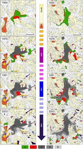
For the period 1954–2003, we have evaluated the urban developments in areas free of landslides and areas affected by old and recent slope instabilities (). In Motta Montecorvino, inspection of the 1954 map reveals that the urban area located on the southern flank of the hilltop was built on an old landslide (red polygons). The urban expansion continues in the southern part of the village during the following years in 1976 and 1991, thus involving sites affected by slope instability. The urban expansion decreases substantially in 2003, with only small new developments on areas with and free of landslides. In Volturino, new urban developments on slopes affected by old landslides can be observed in the surrounding of the municipality center in 1976 and 1991 (red polygons). The urban growth decreased between 1991 and 2003, reducing the urban areas in unstable zones.
Figure 3. Landslides distribution and urban expansion for four different years for Motta Montecorvino (on the left) and Volturino (on the right). The colors of the arrow show the years (i.e. year 1954/1955, 1976/1977, 1990/1991 and 2003) and the inter periods (i.e. inter-period pre-1954, 1954/1955–1976/1977, 1976/1977–1990/1991, and 1990/1991–2003) of the landslides in the multi-temporal map. Legend on the bottom: A: urban expansion on areas free of landslide; B: urban expansion on areas with landslides; C: extension of the urban area in 1954/1955; D: extension of the urban area in 1976/1977; E: extension of the urban area in 1990/1991.
Results of the analysis are also shown in the graphs of . The graph on the left ((a)) shows the total urban areas and the areas affected by landslides in four years (i.e. 1954/1955, 1976/1977, 1990/1991 and 2003); the graph on the right ((b)) shows the urban expansion in the three inter-periods (1954/1955–1976/1977, 1976/1977–1990/1991, and 1990/1991–2003), highlighting areas in zones affected by old and recent landslides.
Figure 4. Interaction between landslides and urban development for the period 1954–2003. The graph on the left (4a) shows the total urban area and the built area on landslides for four years; the graph on the right (4b) shows the urban expansion in three inter-periods, highlighting areas in zones affected by old and recent landslides.
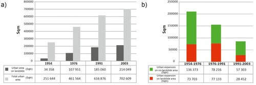
The analysis of graph in (a) reveals an increase of the urban expansion from 0.25 sqkm in 1954 to 0.70 sqkm in 2003, with a growth of areas affected by landslides from 0.03 to 0.21 sqkm. Graph in (b) shows that the urban expansion on areas free of landslide decreases from 0.14 sqkm in 1954–1976 to 0.08 sqkm in 1976–1991 and to 0.06 sqkm in 1991–2003. Similar values can be calculated for the urban expansion in areas with slope instabilities (0.07 and 0.08 sqkm for 1954–1976 and 1976–1991, respectively, while decreases in the last inter-period to 0.03 sqkm for 1991–2003). The information aggregated for both urban areas reveals that the main expansion occurred in the period from 1954 to 1976 and from 1976 to 1991 (overall 81%), while between 1991 and 2003 the expansion was smaller (19%).
5. Discussion
For the study area, we observe an increase of the urban settlements in the 50-years period, on both landslides and no-landslides zones. The expansion is relevant till 1991 and less significant for the last time interval (i.e. 1991–2003), presumably as an effect of socio-economic factors, but the percentage of urban expansion in zones affected by landsliding is quite constant. For this reason, a reliable and complete landslide inventory map is important to understand the spatial and temporal geomorphological evolution of the territory and to support the definition of guidelines and recommendations for an appropriate spatial planning and urban management.
Moreover, in terms of risk awareness and prevention, transferring such outcomes to stakeholders could allow to mitigate indirect damages of landslide impact, such as the socio-economical issues leading to depopulation and worsening of the rural economy (CitationFerrara et al., 2015; CitationPisano et al., 2016).
Software
The Stereo Analyst tool of Esri ArcGIS 10.5.1 was used for the digital stereoscopic interpretation; Qgis 2.6 open source for the editing of the map, the compilation of the digital geodatabase and the data analysis. Corel Draw Graphic Suite 2019 and Adobe Illustrator CC 2019 were used to prepare the maps and the figures.
Supplemental Material
Download PDF (18.3 MB)Acknowledgements
The research is supported by the Civil Protection of the Apulia region, in the framework of the project ‘Integrated assessment of geo-hydrological instability phenomena in the Apulia region, interpretative models and definition of rainfall thresholds for landslide triggering’ funded by the P.O.R. Puglia 2014-2020, Asse V - Azione 5.1. (Project identification number: B82F16003840006).
Disclosure statement
No potential conflict of interest was reported by the author(s).
Additional information
Funding
References
- Ardizzone, F., Basile, G., Cardinali, M., Casagli, N., Del Conte, S., Del Ventisette, C., Fiorucci, F., Garfagnoli, F., Gigli, G., Guzzetti, F., Iovine, G., Mondini, A. C., Moretti, S., Panebianco, M., Raspini, F., Reichenbach, P., Rossi, M., Tanteri, L., & Terranova, O. (2012). Landslide inventory map for the Briga and the Giampilieri catchments, NE Sicily, Italy. J. Maps, 8(2), 176–180. https://doi.org/10.1080/17445647.2012.694271
- Bovenga, F., Nutricato, R., Refice, A., & Wasowski, J. (2006). Application of multi-temporal differential interferometry to slope instability detection in urban/peri-urban areas. Engineering Geology, 88(3–4), 218–239. https://doi.org/10.1016/j.enggeo.2006.09.015
- Cotecchia, F., Santaloia, F., & Lollino, P. (2011). Slow landsliding as effect of hydro-mechanical processes: Resulting damage and mitigation strategies. In L. Picarelli, R. Greco, & G. Urcioli (Eds.), Large slow active slope movements and risk management; Proc. 2° Italian Workshop on Landslides, Napoli, 27–30 Settembre 2011 (pp. 1004–1031). CUES.
- Cotecchia, F., Santaloia, F., Lollino, P., Vitone, C., Pedone, G., & Bottiglieri, O. (2016). From a phenomenological to a geomechanical approach to landslide hazard analysis. European Journal of Environmental and Civil Engineering, 20(9), 1004–1031. https://doi.org/10.1080/19648189.2014.968744
- Cotecchia, F., Vitone, C., Cafaro, F., & Santaloia, F. (2006). The mechanical behavior of intensely fissured high plasticity clays from Daunia. Proc. 2nd Int. Workshop on Characterization Engng. Properties Natural Soils, Singapore, 3, 1975–2003.
- Cotecchia, F., Vitone, C., Santaloia, F., Pedone, G., & Bottiglieri, O. (2015). Instability processes in slopes location of intensely fissured clays: Case histories in the southern Apennines. Landslides, 12(5), 877–893. https://doi.org/10.1007/s10346-014-0516-7
- Crescenzi, E., Iovine, G., & Parise, M. (1994). Analysis of landslide damage in a village in Southern Italy: A preliminary report, Rencontre Internationale des Jeunes Chercheurs en Géologie Appliquée, Lausanne, 68–72.
- Cruden, D. M., & Varnes, D. J. (1996). Landslide types and processes. In A. K. Turner & R. L. Schuster (Eds.), Landslides, investigation and mitigation, special report 247 (pp. 36–75). Transportation Research Board.
- Del Gaudio, V., Pierri, P., & Calcagnile, G. (2012). Analysis of seismic hazard in landslide-prone regions: Criteria and example for an area of Daunia (southern Italy). Natural Hazards, 61(1), 203–215. https://doi.org/10.1007/s11069-011-9886-5
- Del Gaudio, V., Pierri, P., & Wasowski, J. (2003). An approach to time-probabilistic evaluation of seismically induced landslide hazard. Bulletin of the Seismological Society of America, 93(1), 557–569. https://doi.org/10.1785/0120020016
- Ferrara, C., Barone, P. M., & Salvati, L. (2015). Unravelling landslide risk: Soil susceptibility, agro-forest systems and the socio-economic profile of rural communities in Italy. Soil Use and Management, 31(2), 290–298. https://doi.org/10.1111/sum.12185
- Fiorucci, F., Cardinali, M., Carlà, R., Rossi, M., Mondini, A. C., Santurri, L., Ardizzone, F., & Guzzetti, F. (2011). Seasonal landslide mapping and estimation of landslide mobilization rates using aerial and satellite images. Geomorphology, 129(1–2), 59–70. https://doi.org/10.1016/j.geomorph.2011.01.013
- Guzzetti, F., Reichenbach, P., Cardinali, M., Galli, M., & Ardizzone, F. (2005). Probabilistic landslide hazard assessment at the basin scale. Geomorphology, 72(1–4), 272–299. https://doi.org/10.1016/j.geomorph.2005.06.002
- Iovine, G., Parise, M., & Crescenzi, E. (1996). Analisi della franosità nel settore centrale dell'Appennino Dauno. Memorie Della Società Geologica Italiana, 51, 633–641.
- Lollino, P., Cotecchia, F., Elia, G., Mitaritonna, G., & Santaloia, F. (2016). Interpretation of landslide mechanisms based on numerical modelling: Two case-histories. European Journal of Environmental and Civil Engineering, 20(9), 1032–1053. https://doi.org/10.1080/19648189.2014.985851
- Mossa, S., Capolongo, D., Pennetta, L., & Wasowski, J. (2005). A GIS-based assessment of landsliding in the Daunia Apennines, southern Italy. Proceedings of the International Conference “Mass movement hazard in various environments”, 20–21 October 2005, Cracow, Poland, pp. 86–91.
- Parise, M. (2003). Considerazioni sulla franosità dell’Appennino Dauno (Puglia) sulla base dell’elaborazione di carte di attività delle frane. Quad. Geol. Applicata, 10(2), 133–145. (in italian).
- Parise, M., Federico, A., Palladino, G. (2012). Historical evolution of multi-source landslides. In E. Eberhardt, C. Froese, K. Turner, & S. Leroueil (Eds.), Landslides and engineered slopes: Protecting society through improved understanding (pp. 401–407). Taylor & Francis Group.
- Parise, M., & Wasowski, J. (2000). Fenomeni di dissesto nell’Appennino Dauno, ed implicazioni per il patrimonio archeologico e storico-culturale. Atti del Convegno “Condizionamenti geologici e geotecnici nella Conservazione del Patrimonio Storico Culturale”, Torino, 8-9 giugno 2000, 749–756. (in italian).
- Pellicani, R., Frattini, P., & Spilotro, G. (2014). Landslide susceptibility assessment in Apulian southern apennine: Heuristic vs. Statistical methods. Environ. Earth sci, 72(4), 1097–1108. https://doi.org/10.1007/s12665-013-3026-3
- Pieri, P., Gallicchio, S., De Donato, G., Festa, V., Fiore, A., Moretti, M., Tilli, A., & Tropeano, M. (2010). Carta Geologica d'Italia. Foglio 407 “San Bartolomeo in Galdo”, alla scala 1:50.000, Ispra. Litografia Artistica Cartografica s.r.l., Firenze. ISBN: 978-88-240-2967-4.
- Pisano, L., Dragone, V., Vennari, C., Vessia, G., & Parise, M. (2016). The influence of slope instability processes in demographic dynamics of landslide-prone rural areas. Landslides and Engineered Slopes. Experience, Theory and Practice, 3, 1655–1660. https://www.scopus.com/inward/record.uri?eid=2-s2.0-84984845759&partnerID=40&md5=f385fc5495442d7ffd4a132f3eadcf0c
- Pisano, L., Zumpano, V., Malek, Ž, Rosskopf, C. M., & Parise, M. (2017). Variations in the susceptibility to landslides, as a consequence of land cover changes: A look to the past, and another towards the future. Sci. Total Environ, 601, 1147–1159. https://doi.org/10.1016/j.scitotenv.2017.05.231
- Santangelo, M., Gioia, D., Cardinali, M., Guzzetti, F., & Schiattarella, M. (2015). Landslide inventory map of the upper Sinni River valley, Southern Italy. J. Maps, 11(3), 444–453. https://doi.org/10.1080/17445647.2014.949313
- Trigila, A. (2007). Rapporto sulle frane in Italia. Il Progetto IFFI–Metodologia, risultati e rapporti regionali, APAT, Roma, 1-681.
- Wasowski, J., & Bovenga, F. (2015). Remote sensing of landslide motion with emphasis on Satellite Multitemporal Interferometry Applications: An Overview. In J. F. Shroder & T. Davies (Eds.), Landslide Hazards, Risks and Disasters (pp. 345–403). Elsevier. https://doi.org/10.1016/B978-0-12-396452-6.00011-2
- Wasowski, J., Casarano, D., Bovenga, F., Refice, A., Nutricato, R., & Nitti, D. O. (2008). Landslide-prone towns in Daunia (Italy): PS interferometry-based investigation. Proceedings of the Tenth International Symposium on Landslides and Engineered Slopes (Vol 1), Xi'an, China (pp. 513–518). CRC Press.
- Wasowski, J., Casarano, D., & Lamanna, C. (2007). Is the current landslide activity in the Daunia region (Italy) controlled by climate or land use change. In R. McInnes, J. Jackways, H. Fairbank, & E. Mathie (Eds.), Proceedings of the International Conference on Landslides and Climate Change, Ventor, Isle of Wight, UK (pp. 41–49), 21–24 May 2007. Taylor & Francis.
- Wasowski, J., Lamanna, C., & Casarano, D. (2010). Influence of land-use change and precipitation patterns on landslide activity in the Daunia Apennines, Italy. Quarterly Journal of Engineering Geology & Hydrogeology, 43(4), 1–17. https://doi.org/10.1144/1470-9236/08-101
- Wasowski, J., Lamanna, C., Gigante, G., & Casarano, D. (2012). High resolution satellite imagery analysis for inferring surface-subsurface water relationships in unstable slopes. Remote Sensing of Environment, 124, 135–148. https://doi.org/10.1016/j.rse.2012.05.007
- Wasowski, J., & Pisano, L. (2020). Long-term InSAR, borehole inclinometer, and rainfall records provide insight into the mechanism and activity patterns of an extremely slow urbanized landslide. Landslides, https://doi.org/10.1007/s10346-019-01276-7
- Zezza, F., Merenda, L., Bruno, G., Crescenti, E., & Iovine, G. (1994). Condizioni di instabilità e rischio da frana nei comuni dell’Appennino Dauno pugliese. Geologia Applicata e Idrogeologia, 29, 77–141. (in italian).