
ABSTRACT
Khartoum is one of the largest cities in Africa, located immediately south of the junction of the Blue and White Nile rivers in central Sudan. The growth of the Greater Khartoum-Omdurman conurbation arose – without a proper urban plan – from the agricultural wealth created through the completion of three dams, and mostly in the last three decades. Urban expansion was enabled by and helped to enhance the major agricultural expansion of the Gezira clay plains located to the south between the lower Blue and White Nile rivers. The region has been a focus of human settlement for at least 8,000 years, initially by semi-sedentary groups with a fishing-hunting-gathering lifestyle and later by Neolithic groups as shown by hundreds of archaeological sites. Today, Khartoum is a desert city, still very vulnerable to floods triggered by intense convectional storms. Such extreme events may become more common in future, representing a major geomorphological hazard. Moreover, uncontrolled urban and agricultural development is threatening most of the cultural heritage of the region.
1. Introduction
The development of mega-cities is a planetary issue, involving many disciplines that include urban planning, social organisation, assessment of the vulnerability to geo-hazards of infrastructures, and the threat to the natural and cultural heritage (CitationAgapiou et al., 2015; CitationBrandolini et al., in press). In many cases, the development of mega-cities is enhanced by favourable geological conditions – as for instance, the relative low intensity of surface geomorphic processes, the availability of natural resources (firstly water), and the occurrence of lands suitable for agricultural activities and constructing residential buildings and productive plants. Between 1950 and 2018, the world’s urban population grew more than four-fold, from an estimated 0.8 billion to an estimated 4.2 billion. Since 1950, fast-growing urbanisation has taken place in many places of Africa. In most of the continent, an uncontrolled urbanisation process occurred over the last few decades, in tandem with rapid population growth (CitationSani, 2019). As a consequence, Africa’s countries are projected to further increase of urbanisation by 2050, when most of the population (∼50–75%) will be in urban areas (CitationWorld Urbanization Prospects, 2019).
Beside the population increase, a further issue is related to increased urbanisation. In many regions of the planet the development of mega-cities is not properly regulated and is pushed by an increasing demographic pressure and relocation of population from rural areas (CitationWorld Urbanization Prospects, 2019). In this framework, the uncontrolled expansion of urban agglomerates on every available patch of land increases the susceptibility of mega-cities to geo-hazards. In recent times, many devastating events (e.g. floods, landslides, earthquakes, eruptions …) have affected the main cities of Africa, Asia, and South America (CitationAgbola et al., 2012; CitationMahmood et al., 2017). Moreover, the over-exploitation of fertile soils in the vicinity of mega-cities to sustain an increasing population conflicts with the necessity of expanding urban structures. On the other hand, it triggers an irreversible soil loss and pauperisation of natural resources. The archaeological and natural heritage is also involved (CitationAgapiou et al., 2015; CitationLane, 2011; CitationTaha et al., 2020). Archaeological sites, especially the prehistoric ones, may be erased by new buildings or levelled by intensive cultivation practices, while invasive buildings and infrastructures may disrupt natural landscapes and geo-heritage.
Greater Khartoum (the Khartoum-Omdurman conurbation) is one of the largest cities in Africa and has grown rapidly during the last three decades (CitationMohammed et al., 2015), reflecting many of the critical issues mentioned. Khartoum is a mega-city with a continuously increasing population of more than 5.1 million and is located immediately south of the junction of the Blue and White Nile Rivers in central Sudan. Several urban agglomerates surround Khartoum, including Khartoum North (population in excess of one million) that lies north of the confluence and east of the main Nile, and Omdurman (population more than 1.2 million) located west of the Nile River. The recent development of the Khartoum-Omdurman conurbation also involved increasing land exploitation for intensive and extensive cultivation, and tightly interacts with the recent evolution of the Blue and White Nile Rivers. In this paper and the related Main Map, we investigate and reconstruct the recent evolution of the Sudanese conurbation from the visual analysis of open access satellite images and the comparison with its geomorphological and archaeological contexts. Our diachronic reconstruction illustrates the relationship between urbanisation and the natural and anthropogenic dynamics of the Nile Rivers, the consequent increased geomorphological hazards and the threat on the local cultural heritage, with examples of archaeological risk mitigation.
2. Methods
Mapping of the study area took place mainly through the interpretation of remote sensing data retrieved from different sources. Reference topography was derived from a Digital Elevation Model (30-meters resolution) retrieved from the Google Earth Engine (GEE; https://earthengine.google.com/) JAXA/ALOS/AW3D30/V2_2 dataset (CitationTadono et al., 2016). GEE was also employed to obtain the satellite images from 1989 to 2019 (Supplementary Material 1) used to investigate the urban expansion of the conurbation. For each year, a satellite image has been extracted from the GEE Landsat satellite Image Collection (1989, 1999, 2009 USGS Landsat 5 Surface Reflectance Tier 1; 2019 USGS Landsat 8 Surface Reflectance Tier 1). The collection of images has been filtered from January the 1st to December the 31st of each year and reduced to a single image calculating median values. In the output of this process, each pixel is composed of the median value of all the images in the collection at the study area location (https://developers.google.com/earth-engine/reducers_image_collection). The JAVA script developed in the GEE Code Editor is available in Supplementary Material 2.
The use of the historical map of Khartoum edited in 1914 by the geographer Karl Baedeker () clarified the nature of the capital of Sudan at the beginning of the twentieth century CE. This map shows the original core of the city, around which the megalopolis grew. This map was georeferenced in QGIS 3.4 using 8 Ground Control Points (GCPs) manually selected in the 1914 road intersections that are still recognisable in contemporary Khartoum. To perform the georectification process we chose the Thin Plate Spline (TPS) method and a cubic resampling method.
Figure 1. Historical representations of Khartoum and Omdurman. (A) Plan of Khartoum in 1840. (B) ‘Khartûm and Omdurmân’, in Egypt and the Sudan, 1, 7th edition, Leipzig: Karl Baedeker, 1914 freely available in Wikimedia Commons (https://commons.wikimedia.org/wiki/File:1914mapKhartumandOmdurmanbyBaedeker.png; accessed: April 2019). (C) The original McLean’s 1910 Plan of Khartoum based on the 1898 Kitchener Plan (CitationMcLean, 1980). (D) Map of Khartoum from the beginning of the twentieth century, drawn by T. Cook [in:] Ernest Alfred Wallis Budge, Cook’s handbook for Egypt and the Egyptian Sûdân, London 1906, freely available in Wikimedia Commons (https://commons.wikimedia.org/wiki/File:1905mapKhartoumandOmdurmanbyThomasCook.png, accessed April 2019)
![Figure 1. Historical representations of Khartoum and Omdurman. (A) Plan of Khartoum in 1840. (B) ‘Khartûm and Omdurmân’, in Egypt and the Sudan, 1, 7th edition, Leipzig: Karl Baedeker, 1914 freely available in Wikimedia Commons (https://commons.wikimedia.org/wiki/File:1914mapKhartumandOmdurmanbyBaedeker.png; accessed: April 2019). (C) The original McLean’s 1910 Plan of Khartoum based on the 1898 Kitchener Plan (CitationMcLean, 1980). (D) Map of Khartoum from the beginning of the twentieth century, drawn by T. Cook [in:] Ernest Alfred Wallis Budge, Cook’s handbook for Egypt and the Egyptian Sûdân, London 1906, freely available in Wikimedia Commons (https://commons.wikimedia.org/wiki/File:1905mapKhartoumandOmdurmanbyThomasCook.png, accessed April 2019)](/cms/asset/2a3ffee0-0196-4157-86d5-bd22f76960ef/tjom_a_1758810_f0001_oc.jpg)
The urbanisation of the city and the acceleration of its expansion especially in the last thirty years (1989–2019) were investigated considering the historical database of the GoogleEarth™ software that allows access to satellite images dating back several decades. With this support and thanks to the high visibility of satellite data of arid regions (CitationZerboni et al., 2015), we documented in QGIS the expansion of urban areas and cultivation in selected regions. In the Main Map, we show four main steps of the development of the region and associated shifts in the human exploitation of the land over the last 30 years, as detected by visual investigation of open access satellite imageries. We do not define formal land use units, we only attribute to each patch of land two possible attribute: (i) urban area (including all buildings and infrastructures), or (ii) farmland (including all types of crop). We provide snapshots of the growing urbanisation in the Khartoum-Omdurman areas in 1989, 1999, 2009, and 2019 (see Supplementary Material 1). Because of the high seasonal variability of the White and Blue Nile Rivers, we show the river shape as documented on satellite images collected on 10 October 2009. Expansion periods were categorised at 4-years intervals in order to emphasise the main phases of the urban development of Khartoum.
The database of archaeological sites used in the map came from data published in CitationUsai and Salvatori (2005, Citation2006a, Citation2006b), CitationCremaschi et al. (2007), CitationSalvatori and Usai (2008) and CitationWilliams et al. (2015), and unpublished data collected during field survey along the western bank of the White Nile in the framework of the al-Khiday Archaeological Project. The project has two distinct goals: rescuing cultural heritage of the region and reconstructing the local population history. It is devoted to the archaeological investigation of sites located along the western bank of the White Nile, between Omdurman and the Jebel Aulia Dam, and ranging from the Palaeolithic to historical times (CitationUsai & Salvatori, 2002; CitationUsai, 2003; CitationUsai & Salvatori, 2019, and references therein).
The geomorphological features (fluvial, slope, residual landforms) of the area were determined by analysis of published data (see: CitationWilliams, 2009, Citation2019; CitationWilliams et al., 2003, Citation2015; CitationZerboni, 2011, and references therein), and interpretation of satellite images coupled with field survey carried out in the last decades to interpret the evolution of the Nile Rivers. In order to illustrate the current geomorphological setting and to better observe the interaction between natural and urban landscape, we use the most recent source as our basis for cartography, corresponding to the 2019 GoogleEarth™ satellite imagery (CitationGoogleEarth™, 2019). In this way, a comparison could be made diachronically on the effect of natural changes on the evolution of the city and its constraints, highlighting the occurrence of geomorphological risks to the city and its cultural heritage. The main categories of landforms included in the map are related to the fluvial activity of the Blue and White Nile Rivers, mainly as depositional landforms. Erosional landforms on the pediment outside the Nile valley were also mapped, as well as the main bedrock outcrops.
3. Results
3.1. Geomorphological features
From a geomorphological standpoint, the megacity of Khartoum-Omdurman lies around the confluence of the Blue and White Nile, which join to become the main Nile River. This junction represents the northern apex of the Gezira, a vast low-angle alluvial fan bounded to the east by the present Blue Nile, to the west by the White Nile, and to the south by the Manaqil Ridge (CitationWilliams, 2009, Citation2019; CitationWilliams et al., 2003, Citation2015). The Gezira sediments were deposited by the Blue Nile during the last 30 million years (CitationWilliams, 2019). During the late Pleistocene and early Holocene, the Blue Nile flowed across the Gezira in a series of distributary channels. These sandy paleochannels were progressively abandoned and are clearly evident on the surface of the Gezira fan (CitationWilliams, 2009, Citation2019). The northernmost paleochannel lies just south of the Khartoum conurbation and features at the bottom of the Main Map. Beyond the Gezira to the west of the White Nile and to the east of the Blue Nile, vast areas of pediment lie flat on the landscape, connected to the riverbanks by a sloping surface made by a depositional glacis (CitationWilliams, 2009; CitationWilliams et al., 2015; CitationZerboni, 2011). Outcrops of Nubian sandstone are sparse in the same area (CitationGeological Research Authority of Sudan, 1988).
The settings of the two Niles in the area of their confluence are very different (CitationWilliams, 2009, Citation2019). The White Nile occupies a wide and mostly straight bed with low-energy sediment transport. The old riverbed upstream of the Jebel Aulia dam is nowadays largely underwater. Downstream of the dam the bank overlying the pediment that borders the Gezira and the western bank of the river are only occasionally flooded. In such conditions, a large area of temporary bars and islands, often settled and cultivated, align with the new riverbanks; their shape changes drastically in short periods of time according to the intensity of seasonal floods. The only permanent river island is Tuti Island, a half-moon-shaped strip of land at the junction of the two rivers. The Blue Nile is narrow with very visible meanders depositing new sedimentary material at the bends in front of the more stable cultivated land. On its eastern bank two successive terraces are cut into the sediments connecting to the glacis to the east. Below the confluence of the Blue and White Nile Rivers, a third terrace can be found on the eastern bank (CitationWilliams, 2019).
3.2. Historical urban development
The Blue and the White Nile Rivers naturally create three separate zones in which three different centres were established: Khartoum Town, Omdurman (or Umm-Durman), and Khartoum North. These three settlements have totally different urban characters depending on distinct historic town-forming factors:
Khartoum Town. The 1910 urban plan for the development of the city (CitationMcLean & Hunt, 1911) represented the first occurrence of proper town planning in Sudan (CitationHamid & Bahreldin, 2014). This plan shows a rectangular grid crossed by diagonal roads, well suited for military intervention in case of riots (). The 1910 plan of Khartoum Town is still partially evident (Main Map) and is characterised by a combination of an orthogonal layout with multiple axes that resembles the British Union Jack (CitationMcLean, 1980).
Omdurman. The small town of Umm-Durman began to develop as an Arab-Islamic city during the Mahdist period (1885–1898). The town had the appearance of most of the Muslim towns of west and central Africa (CitationAhmad, 2000); but, despite many attempts at regulating its development, residential districts sprawled uncontrollably () towards the desert region west of the Nile River (CitationHassan et al., 2017a, Citation2017b).
Khartoum North. The Baedeker’s 1914 Map () illustrates the structure of Khartoum North as made up of two individual orthogonal layouts; each of them includes a main square and military buildings located along the river (CitationHassan et al., 2017a). From the beginning of the twentieth century, Khartoum North progressively became an industrial centre.
3.3. Urban and agricultural land exploitation 1989–2019
The population growth that occurred in the Khartoum-Omdurman conurbation in the last 30 years had a direct impact on urban and infrastructural expansion. In the Main Map, we examined the steps of the urbanisation expansion between 1989 and 2019. Initially, the urban expansion occurred northwards along the main Nile River, because that is the major commercial route running from south to north of the country. The linear pattern of roads encouraged a linear pattern of development, whereby main roads attract shops and business centres (CitationRefaat, 2015). A second direction of the urbanisation of Khartoum proceeded east and west into the rural countryside encircling pristine rural communities and often absorbing old villages (CitationLane, 2011; CitationMoller-Jensen & Knudsen, 2008). The conurbation took its elongated shape and grew extensively in length mainly as a consequence of agricultural activities (). Several factors promoted the intensive exploitation of the fertile sediments along the Nile river banks and the whole of Tuti Island: (i) an increasing food demand driven by the demographic expansion of the growing conurbation, (ii) limited opportunities for crop production in the arid lands surrounding Khartoum and Omdurman, and (iii) the scarcity of water resources.
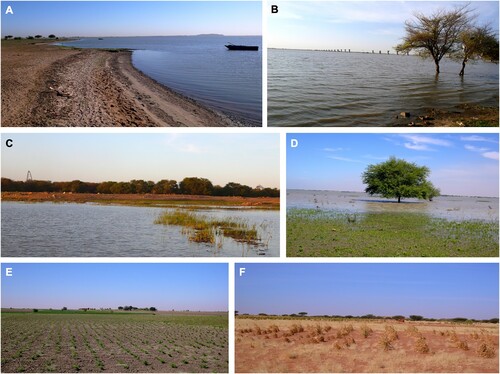
Figure 2. Field pictures from the study area. (A) The shoreline of the White Nile. (B) Building of a new bridge on the White Nile. (C) The urban forest of Khartoum, at the confluence between the Blue and White Niles. (D) Flooding along the White Nile. (E) Traditional cultivation along the shorelines of the White Nile and (F) inland.
Between 1989 and 1999 the mainland around the metropolitan area was cultivated but the rapid growth of the city increased pressure on fertile areas and led to the conversion of arable to building land (CitationRefaat, 2015). At the beginning of the 2000s, a transformation of cultivable land to industrial and residential uses involved the whole area, most intensely in Khartoum North. In the same period, the urban expansion towards the desert region east and west of the Nile had a great acceleration, leading to the spread of Omdurman and Khartoum North into previously unsettled areas. In the last ten years, villages increased in number and size along the pediment at the western bank of the Nile River, along a strip of land up to 10/12 km from the riverbank. Several factors favoured this urban development: proximity to water (pumped from the White Nile), the control of the Jebel Aulia dam over seasonal flooding (CitationZaghloul et al., 2017), and the availability of raw material (i.e. clay) to produce mud bricks (CitationZerboni et al., 2018).
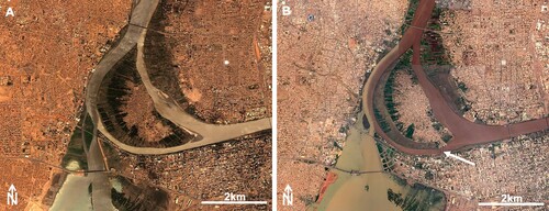
Along the Nile River banks and on Tuti Island agriculture still persisted notwithstanding the uncontrolled urban expansion registered since 1989 (CitationDavies, 1994). In the late 2000s, the building of a bridge connecting Khartoum to the Tuti Island fuelled the urban expansion and reduction of cultivated land on the island (). However, in Khartoum itself rural areas have progressively shifted from the city centre to its periphery in the last 30 years, especially southward, where the cultivated areas increased considerably (CitationSchumacher et al., 2009). The expansion of modern agricultural activities in the Gezira area is primarily favoured by the occurrence of fertile soils formed on the Pleistocene Nile sediments (CitationBuursink, 1971; CitationWilliams et al., 1982).
Figure 3. Google Earth™ satellite imageries of the Tuti Island in (A) 2003 and (B) 2019 showing the urban expansion and reduction of cultivated land on the island after the building of the bridge (indicated by the arrow).
4. Geomorphological hazards
As with most arid urban centres, one of the biggest geomorphological hazards menacing Khartoum and Omdurman is related to dust storms. The vulnerability of the mega-city to haboob (strong dust storm) has known for many decades (CitationSutton, 1925) and recurrent dust events are recorded (CitationChobrial et al., 1985; CitationLawson, 1971). Urbanisation led to the increase of impervious surfaces, intensifying the heat island in the city. As a consequence, in the dry season dust storms and heat waves have increased their incidence (CitationMahmoud et al., 2014). Moreover, the overexploitation of local silty soils increases wind erosion, thus amplifying the frequency and intensity of haboobs (CitationBabiker, 1982). As rainfall is concentrated in few heavy showers, impervious surfaces amplify the frequency of streets flooding in the rainy season. Moreover, the local drainage of the city is inefficient in responding to erratic rain, thus floods are one of most dangerous hazards threatening the conurbation. Exceptional flooding is recurrent in the region, highlighting the vulnerability of the unplanned urban areas (CitationMahmoud et al., 2014; CitationWalsh et al., 1994).
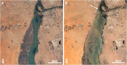
The effect of floods is not the same in the whole area. Three distinct types of flooding occur: from the three Nile rivers, from local ephemeral streams, and from urban runoff (CitationDavies & Walsh, 1997; CitationWalsh et al., 1994). Nile flooding occurs each year between July and September when the Blue Nile reaches its peak discharge; for that reason, a seasonally flooded agricultural zone along the Nile Rivers exists (). Almost for the same reason, traditional villages occupy topographic locations above current flood levels. Floods extending outside the normally flooded areas are the result of intense and highly localised downpours when prolonged heavy rain occurs in Blue Nile’s headwater in the Ethiopian Highlands (CitationWilliams, 2019). The occurrence of the Jebel Aulia dam can mitigate the most dramatic effects of flooding along the White Nile, but the Blue Nile flood partially blocks the flow of the White Nile, thus raising its level (). As noted by CitationWalsh et al. (1994) the banks east of the White Nile close to the confluence are lower than those of the Blue Nile that is more incised. Consequently, when the Nile flooding occurs, it starts inundating from the White Nile (). Furthermore, high Blue Nile levels may prevent the free passage of their waters into the Nile favouring floods, a process described by Sir William Willcocks more than a century ago (CitationWillcocks, 1904). Due to reduced infiltration, local heavy rainstorms produce street flooding and overland flow. Additionally, in recent years the accumulation of wood and sediments against the pillars of the Omdurman Bridge is amplifying the dam effect of the Blue Nile, increasing the susceptibility of the uppermost reaches of the White Nile to flooding (). The same issue is evident at each bridge crossing the rivers as a consequence of a very poor maintenance of the pillars. Finally, flooding by local ephemeral watercourses (such the Khor Abu Anga and Khor Shambat crossing Omdurman) occurs following prolonged rainfall.
Figure 4. (A) Regular flowing of the White Nile (Google Earth™, December 31st 2016) compared with (B) the same river during a flooding, whose consequences are enhanced by the dam effect (see the arrow) of the high level of the Blue Nile (Google Earth™, September 11th 2019). In (B) note the White Nile inundating the rural areas in the vicinity of the city.
There is some evidence that severe floods in Khartoum are becoming more common. During 1900–1957 annual rainfall at Khartoum ranged between 48 and 380 mm, only exceeding 250 mm in five years. The 200-mm Khartoum storm of 4–5 August 1988 had an estimated return period between 400 and 700 years (CitationHulme & Trilsbach, 1989). On 16 August 1999 Khartoum as much rain fell in 6 h at Khartoum as usually fell in a single year, causing catastrophic floods (CitationWilliams & Nottage, 2006).
5. Threats to cultural heritage
5.1. Local archaeological record
Pleistocene to Holocene archaeological sites in Sudan are widely distributed along the shorelines of the Nile Rivers and their seasonal tributaries, and the first evidence dating to these periods was recovered at Khor Abu Anga (CitationArkell, 1949a), Khartoum Hospital (CitationArkell, 1949b), and Shaheinab (CitationArkell, 1953).
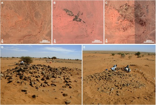
The archaeological heritage of the White Nile region includes concentrations or sporadic prehistoric vestiges of Mid-Upper Pleistocene/Palaeolithic hunters, multiphase settlements of Mesolithic hunter-gatherer-fisher and Neolithic societies, cemeteries (from the Mesolithic to the Islamic periods), and a number of isolated findings (fireplaces, lithics, pottery, stone structures) (CitationSalvatori & Usai, 2008; CitationUsai, 2003, Citation2006; CitationUsai & Salvatori, 2002, Citation2006a). Palaeolithic sites or sporadic occurrences were located mainly near the Jebels, about 30 kilometres west of the White Nile, while sites pertaining to the Holocene period (especially Mesolithic and Neolithic) were mostly located along the riverbank. Mesolithic/Neolithic sites appear as mounds (CitationSalvatori et al., 2011; CitationZerboni, 2011), whose surface is reduced by erosion to a carpet of artefacts (pottery, lithic, human and faunal remains). Most of the sites have been later reused as Meroitic and Post-Meroitic burial grounds. Post-Meroitic cemeteries are ubiquitous, hosting hundreds of tumuli () with super-structures made mainly of stone, when located close to the Jebels, and of earth, when closer to the Nile. Evidence dating to the Christian and Islamic periods is less frequent in the area (CitationUsai, 2003, Citation2006; CitationUsai & Salvatori, 2002, p. 2006; CitationSalvatori & Usai, 2008). Among the many Mesolithic/Neolithic sites, some have been selected for systematic excavation and those located at the al-Khiday area have produced astounding results that contributed to our comprehension of these hunter-gatherer-fisher pottery-bearing societies that are a characteristic of the Nile valley and other North African regions (CitationSalvatori, 2012; CitationSalvatori & Usai, 2019; CitationUsai and Salvatori, 2006a).
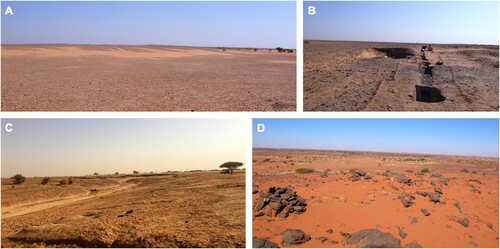
Figure 5. Some examples of the archaeological sites located in the White Nile area: (A) Mesolithic/Neolithic mound-site at al-Khiday (CitationSalvatori et al., 2011); (B) the same during the excavation; (C) view of the Palaeolithic site of al-Jamrab (CitationSpinapolice et al., 2018); (D) stone monuments.
5.2. Archaeological risk and possible mitigation strategy
The archaeological record of the region at the confluence of the two Niles is extremely rich and facing opposite dynamics. The natural behaviour of the Nile Rivers has a twofold effect on archaeological sites: the deposition of silts is contributing to the preservation of the archaeological record by burying it, but erosion related to flooding menace the survival of archaeological settlements established along the riverbanks.
Still, human pressure is the greatest threat to the preservation of the local archaeological record, mainly distributed along the banks of the Nile and its two great tributaries. As evident from the case of the west bank of the White Nile, archaeological sites are being progressively enclosed in the urban tissue of the southern expansion of Omdurman (). Moreover, the infrastructures planned to serve the new Khartoum international airport represent a great menace to the cultural heritage. These processes are obviously destructive as archaeological sites are levelled or removed to establish modern structures; the main consequence is the loss of part of the local archaeological heritage ( and ). An emblematic case is that of a Neolithic site at el-Oshara – also the site of a Post-Meroitic tumulus excavated by CitationMarshall and Adam (1954) – whose anthropogenic sediments were used to build mud-brick houses, now decorated with fragments of prehistoric pottery and quartzite flakes. In the larger territory, including the jebels to the west of the White Nile, urban expansion along the river or in downtown Omdurman-Khartoum has strongly affected the archaeological evidence. As an example, at the large Post-Meroitic cemetery 10-U-3 located about 16 km west of the White Nile including 275 graves stone super-structures were completely removed from all tumuli (). Fortunately, in this case, reconnaissance archaeology operations provided a map of the cemetery locating the underground burial chambers.
Figure 6. Satellite imagery of the western bank of the White Nile indicating the position of the main archaeological sites of the region, and illustrating the steps of urban expansion in the period 1989–2019.
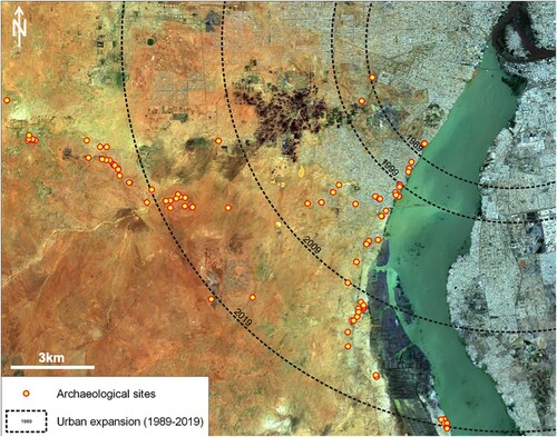
Figure 7. Google Earth™ satellite imageries of the Post-Meroitic cemetery at site 10-W-8 occupied and partially destroyed by the urban expansion of the el-Salha quarter (each dark spot is an earthen tumulus): (A) in 2006, (B) in 2019, (C) some Post-Meroitic earthen tumuli.
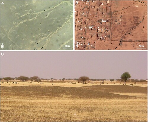
Figure 8. The Post Meroitic cemetery 10-U-3 from Google Earth™ satellite imageries progressively and rapidly devastated by quarrying activity: (A) in 2014, (B) in 2016, (C) in 2019. (D-E) Field pictures of stone tumuli.
Historically, some of the most important archaeological sites located beneath the extant Khartoum city centre (as Khartoum Hospital or El-Qoz) were investigated by proper excavations (CitationArkell, 1949b, Citation1953) before their areas were fully incorporated in the urban plan. The list of cultural heritage sites destroyed () or threatened () by the uncontrolled expansion of the mega-city along the White Nile is long, and many attempts were made to prevent the destruction of the archaeological record or, at least, to excavate the most significant sites (). At el-Salha and al-Khiday, for instance, the Mesolithic, Neolithic and Post-Meroitic 10-X-6 site (CitationUsai and Salvatori, 2006b) is now almost completely covered by a modern cemetery (); the Post-Meroitic 10-X-1 cemetery has now disappeared under civil buildings; the Mesolithic and Neolithic 10-X-4 and late Mesolithic 10-W-4 sites (CitationSalvatori et al., 2014) are now cancelled by the expansion of the el-Salha quarter. A specific Sudanese law was established to protect the national cultural heritage and prevent its destruction (Antiquities Protection Ordinance of 1999). Our preventive surveys and rescue excavations should suggest the importance of salvage archaeology as a preliminary tool to urban planning at least to preserve the memory of the archaeological and historical significance of a region to posterity, something that can be spent in the future in the tourism sphere, a motor of the economy of the country.
Figure 9. Rescue archaeology of the Mesolithic site 10-X-6. Google Earth™ satellite imageries of the mound hosting the archaeological sites in (A) 2005 (soon after the end of the excavation) and in (B) 2019. The red line is the extension of site 10-X-6, the grey square the area of the archaeological excavation, and the black line indicates the expansion of the modern cemetery. Note the increase of modern graves on top of the mound, especially in its eastern flank, and the expansion of the buildings. (C) General view of the excavation. (D) Detail of one of the Post-Meroitic graves.
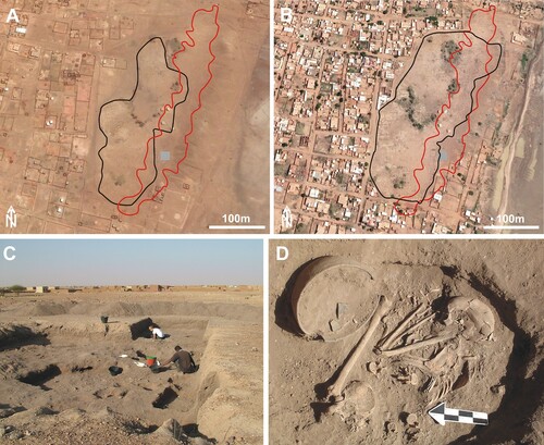
Table 1. List of the major archaeological evidence lost due to uncontrolled urban expansion of the Khartoum-Omdurman conurbation along the western bank of the White Nile.
Table 2. List of the major archaeological sites threatened by the urban expansion along the road of the new International Airport of Khartoum.
The same approach should be considered for the geo-heritage (CitationBrilha et al., 2018; CitationPelfini & Bollati, 2014). The region includes a number of different landscape features preserving high scientific and cultural values (geologic, geomorphological and palaeoenvironmental values), such as the riverbanks of the Nile Rivers, Pleistocene and Holocene lake and marsh deposits, and the fields of termite mounds. An uncontrolled urban and agricultural expansion threatens their preservation.
6. Conclusion
The conurbation of Khartoum and Omdurman – or Greater Khartoum – is an African megacity growing very rapidly in an arid region. The almost out-of-control expansion of the city is triggered by social and environmental factors: migrations, demographic increase, water and fertile land availability. Unfortunately, the lack of efficient urban planning exposes the conurbation to many hazards. Geomorphologically, many parts of the megacity are flood-prone, with new settlements built very close to flooding areas and ephemeral streams. The progressive reduction of fertile land caused by urban expansion will be a major problem for a large part of inhabitants, whose main income comes from traditional agriculture (CitationLancelotti et al., 2019).
Local cultural and geo-heritage is also under threat. CitationRefaat (2015) recently argued that Khartoum needs to develop strategies, plans, designs, and policies that would restore and preserve the landscape cultural local identity of the city. This becomes mandatory if the local cultural landscape is to be preserved for future generations. In a recent workshop discussing the future sustainable development of Khartoum (CitationHamid & Bahreldin, 2014), the preservation and valorisation of the archaeo- and geo-heritage was not discussed. However, the relevance of the on-going destruction, with the number of archaeological sites that have disappeared by the uncontrolled development of the urban expansion in an area as large as the el-Salha quarter in only ten years, should push local authorities to reflect on the opportunity to implement the legislative instruments already available for prevention. In this sense, the role of reconnaissance and salvage archaeology is key as a preliminary tool for urban planning. Finally, fluvial landforms and features of the arid landscape could be valorised to highlight the hidden geomorphology, the potential influence of geomorphic hazard, and the relationship with the local cultural heritage (CitationBrandolini et al., 2019). The integration of the cultural and geological heritage of the Khartoum area – as much as of the whole Sudan – could become the motor of the future development of local communities, mostly based on sustainable cultural tourism.
Software
QGIS 3.4 was the software used for the management of the mapping project in all phases. Satellite images observation was done with the help of Google Earth Pro 7.3.
Supplemental Material
Download Zip (7.3 MB)Zerboni_et_al_Main_Map_revised.pdf
Download PDF (2.5 MB)Acknowledgments
The archaeological survey and excavations of the western White Nile region were directed by D. Usai and S. Salvatori, and performed since 2000 by the Italian Archaeological Mission of the Centro Studi Sudanesi & Sub-Sahariani (Treviso, Italy) in the framework of the el-Salha/al-Khiday Project established to document prehistoric and historic archaeological evidence. From 2000 to 2011, the activities were performed under the aegis of the Italian Institute for Africa and Orient (Roma). The General Director of the National Corporation for Antiquities and Museums and the other Sudanese colleagues of the NCAM are thanked for constant support. Finally, a great contribution to the success of the project is also due to the Italian Embassy in Sudan.
Disclosure statement
No potential conflict of interest was reported by the author(s).
Additional information
Funding
Related Research Data
References
- Agapiou, A., Alexakis, D. D., Lysandrou, V., Sarris, A., Cuca, B., Themistocleous, K., & Hadjimitsis, D. G. (2015). Impact of urban sprawl to cultural heritage monuments: The case study of Paphos area in Cyprus. Journal of Cultural Heritage, 16(5), 671–680. https://doi.org/10.1016/j.culher.2014.12.006
- Agbola, B. S., Ajayi, O., Taiwo, O. J., & Wahab, B. W. (2012). The August 2011 flood in Ibadan. Nigeria: Anthropogenic Causes and Consequences. International Journal of Disaster Risk Science, 3, 207–217. https://doi.org/10.1007/s13753-012-0021-3
- Ahmad, A. M. (2000). Khartoum Blues: The `deplanning’ and decline of a capital city. Habitat International. https://doi.org/10.1016/s0197-3975(99)00046-6
- Arkell, A. J. (1949a). The Old Stone Age in the Anglo-Egyptian Sudan, Occasional papers of the Sudan Antiquities Service, no. 1.
- Arkell, A. J. (1949b). Early Khartoum. Oxford University Press.
- Arkell, A. J. (1953). Shaheinab. Oxford University Press.
- Babiker, A. A. G. (1982). Urbanization and desertification in the Sudan with special reference to Khartoum. GeoJournal, 6(1), 69–76. https://doi.org/10.1007/BF00446596
- Bahreldin, I. Z. (2006). Preparing for urban future Riverside development, concepts and strategies; a case study of Khartoum-Sudan. Jeddah International Urban Forum-JIUFX, 1–15.
- Brandolini, F., Pelfini, M., & Cremaschi, M. (2019). Estimating the potential of archaeo-historical data in the definition of geomorphosites and geo-educational itineraries in the central Po Plain (N Italy). Geoheritage, 11(4), 1371–1396. https://doi.org/10.1007/s12371-019-00382-1
- Brandolini, P., Cappadonia, C., Luberti, G. M., Donadio, C., Stamatopoulos, L., Di Maggio, C., Faccini, F., Stanislao, C., Vergari, F., Paliaga, G., Agnesi, V., Alevizos, G. & Del Monte M. (in press). Geomorphology of the Anthropocene in Mediterraneanurbanareas. Progress in Physical Geography, https://doi.org/10.1177/0309133319881108
- Brilha, J., Gray, M., Pereira, D. I., & Pereira, P. (2018). Geodiversity: An integrative review as a contribution to the sustainable management of the whole of nature. Environmental Sceince and Policy, 86, 19–28. https://doi.org/10.1016/j.envsci.2018.05.001
- Buursink, J. (1971). Soils of the central Sudan [Published doctoral thesis]. Utrecht University.
- Chobrial, S. I., Sharif, S. M., Ateem, M. E., & Eltigani, M. (1985). Dust storms in the Sudan: Intensity and particles’ characteristics. Jordan International Electrical & Electronic Engineering Conference, April, 28 – May 1, 1985. Amman, 326.
- Cremaschi, M., Salvatori, S., Usai, D., & Zerboni, A. (2007). A further tessera to the huge mosaic: Studying the ancient settlement pattern of the El Salha region (south-west of Omdurman, Central Sudan). In K. Kroeper, M. Chłodnicki, & M. Kobusiewicz (Eds.), Archaeology of the Earliest North-eastern Africa (pp. 39–48). Poznan Archaeological Museum.
- Davies, H. R. J. (1994). A rural “eye” in the capital: Tuti Island, Khartoum, Sudan. GeoJurnal, 33, 387–392. https://doi.org/10.1007/BF00806421
- Davies, H. R. J., & Walsh, R. P. D. (1997). Historical changes in the flood hazard at Khartoum, Sudan: Lessons and warnings for the future. Singapore Journal of Tropical Geography, 18(2), 123–140. https://doi.org/10.1111/1467-9493.00012
- Geological Research Authority of Sudan. (1988). Geological map of Sudan 1:1,000,000, sheet 9 –Khartoum. Geological Research Authority of Sudan.
- GoogleEarthtm. (2019). Khartoum, elev 385 m, 15/07/2019. Maxar Technologies, 2019. Retrived from July 30, 2019.
- Hafazalla, A. A. (2008). The urban development planning of greater Khartoum: Coping with urban dynamics. Urban Housing in Sudan, Proceedings of the architects’ third scientific conference, Khartoum, Sudan, 28th-30th April.
- Hamid, G. M., & Bahreldin, I. Z. (2014). Khartoum 2030 towards An Environmentally-Sensitive Vision for the development of Greater Khartoum, Sudan. L’architettura Delle Città – The Journal of the Scientific Society Ludovico Quaroni, 2. http://www.architetturadellecitta.it/index.php/adc/article/view/50
- Hassan, S. S., Kobylarczyk, J., Kuśnierz-Krupa, D., Chałupski, A., & Krupa, M. (2017a). Urban planning of Khartoum. History and modernity part I. History. Wiadomości Konserwatorskie. https://doi:10.17425/WK51KHARTOUM
- Hassan, S. S., Kobylarczyk, J., Kuśnierz-Krupa, D., Chałupski, A., & Krupa, M. (2017b). Urban planning of Khartoum. History and modernity part II. Modernity. Wiadomości Konserwatorskie. https://doi:10.17425/WK52KHARTOUM
- Hulme, M., & Trilsbach, A. (1989). The August 1988 storm over Khartoum. Weather, 44(2), 82–90. https://doi.org/10.1002/j.1477-8696.1989.tb06983.x
- Lancelotti, C., Biagetti, S., Zerboni, A., Usai, D., & Madella, M. (2019). Ethnoarchaeology and archaeology of rainfed cultivation in arid to hyper-arid lands of North Africa. Antiquity, 93(370), 1026–1039. https://doi.org/10.15184/aqy.2019.109
- Lane, P. J. (2011). Future urban growth and archaeological heritage management: Some implications for research activity in Africa. Conservation and Management of Archaeological Sites, 13(2–3), 134–159. https://doi.org/10.1179/175355211X13179154165980
- Lawson, T. J. (1971). Haboob structure at Khartoum. Weather, 26(3), 105–112. https://doi.org/10.1002/j.1477-8696.1971.tb07402.x
- Mahmood, M. I., Elagib, N. A., Horn, F., & Saad, S. A. G. (2017). Lessons learned from Khartoum flash flood impacts: An integrated assessment. The Science of the Total Environment, 601–602, 1031–1045. https://doi.org/10.1016/j.scitotenv.2017.05.260
- Mahmoud, M. I., Elagib, N. A., Gaese, H., & Heinrich, J. (2014). Rainfall conditions and rainwater harvesting potential in the urban area of Khartoum. Resources, Conservation and Recycling, 91, 89–99. https://doi.org/10.1016/j.resconrec.2014.07.014
- Marshall, K., & Adam, A. R. (1954). Excavation of a mound grave at Ushara. KUSH, I, 40–46.
- McLean, W. H. (1980). The Planning of Khartoum and Omdurman in the earliest period of British rule. Urbanization and Urban Life in Sudan, Hull Department of Sociology, Hull University.
- McLean, W. H., & Hunt, G. (1911). Some municipal engineering problems in the Tropics. In A. Balfour (Ed.), Report of Wellcome Tropical Research Laboratories at the Gordon Memorial College. Volume B: General Science. Wellcome Tropical Research Laboratories.
- Mohammed, E. A., Alawad, H. M., Zeinelabdein, K. A. E., & Ali, A. G. (2015). Urban expansion and population growth in Omdurman City, Sudan using geospatial technologies and statistical approaches. Journal of South American Earth Sciences, 2, 1–7.
- Moller-Jensen, L., & Knudsen, M. H. (2008). Patterns of population change in Ghana (1984–2000): urbanization and frontier development. GeoJournal, 73(4), 307–320. https://doi.org/10.1007/s10708-008-9209-x
- Pelfini, M., & Bollati, I. M. (2014). Landforms and geomorphosites ongoing changes: Concepts and implications for geoheritage promotion. Quaestiones Geographicae, 33(1), 131–143. https://doi.org/10.2478/quageo-2014-0009
- Refaat, M. H. (2015). Urban architecture for sustaining local identity of cultural landscapes: A study of water front development in Khartoum, Sudan. International Journal of Development and Sustainability, 4, 1.
- Salvatori, S. (2012). Disclosing archaeological Complexity of the Khartoum Mesolithic. New data at the site and regional level. African Archaeological Review, 29(4), 399–472. https://doi.org/10.1007/s10437-012-9119-7
- Salvatori, S., & Usai, D. (2008). El-Salha project 2005. New Khartoum Mesolithic sites from Central Sudan. KUSH, XIX, 87–96.
- Salvatori, S., & Usai, D. (2019). The neolithic and ‘Pastoralism’ along the Nile: A dissenting view. Journal of World Prehistory, 32(3), 251–285. https://doi.org/10.1007/s10963-019-09132-1
- Salvatori, S., Usai, D., Faroug, M. A., Di Matteo, A., Iacumin, P., Lindseele, V., & Magzoub, M. K. (2014). Archaeology at Al Khiday: New insight on the prehistory and history of Central Sudan. In J. R. Anderson & D. A. Welsby (Eds.), The fourth cataract and beyond. Proceedings of the 12th international conference of Nubian Studies (pp. 243–257). Peeters.
- Salvatori, S., Usai, D., & Zerboni, A. (2011). Mesolithic site formation and palaeoenvironment along the White Nile (central Sudan). African Archaeological Review, 28(3), 177–211. https://doi.org/10.1007/s10437-011-9095-3
- Sani, M. (2019). The paradox of post-colonial urban growth in the city of Zaria, Nigeria. Journal of Geography and Regional Planning, 12(1), 1–9. https://doi.org/10.5897/JGRP2018.0714
- Schumacher, J., Luedeling, E., Gebauer, J., Saied, A., El-Siddig, K., & Buerkert, A. (2009). Spatial expansion and water requirements of urban agriculture in Khartoum, Sudan. Journal of Arid Environments, 73(4–5), 399–406. https://doi.org/10.1016/j.jaridenv.2008.12.005
- Spinapolice, E. E., Zerboni, A., Meyer, M., & Usai, D. (2018). Early human occupation at al-Jamrab (White Nile region, central Sudan): a contribution to the understanding of the MSA of Eastern Africa. Journal of African Archaeology, 16(2), 193–209. https://doi.org/10.1163/21915784-20180010
- Sutton, L. J. (1925). Haboobs. Quarterly Journal of the Royal Meteorological Society, 51(213), 25–30. https://doi.org/10.1002/qj.49705121305
- Tadono, T., Nagai, H., Ishida, H., Oda, F., Naito, S., Minakawa, K., & Iwamoto, H. (2016). Generation of the 30 m-mesh global digital surface model by ALOS PRISM. International Archives of the Photogrammetry, Remote Sensing & Spatial Information Sciences. XLI-B4, 157–162. https://doi.org/10.5194/isprsarchives-XLI-B4-157-2016
- Taha, M. M. N., Al-Hashim, M. H., & El-Asmar, H. M. (2020). Geoarcheomorphosites under strong urbanization pressure at the Tineh Plain, NE of the Nile Delta, Egypt. Geoheirtage, 12(1), 24. https://doi.org/10.1007/s12371-020-00444-9
- Usai, D. (2003). The Is.I.A.O. El Salha project. KUSH, XVIII, 173–182.
- Usai, D. (2006). The El Salha Project, Sudan”. Actes of the XIVth Congress of the U.I.S.P.P., Liège, Belgium, 2–8 September 2001, general Sessions and Posters, BAR International Series 1522, 207–212.
- Usai, D., & Salvatori, S. (2002). The IsIAO el-Salha archaeological project. Sudan & Nubia, 6, 67–72.
- Usai, D., & Salvatori, S. (2005). The IsIAO archaeological project in the El Salha area (Omdurman South, Sudan): results and perspectives. AFRICA LX, 3–4, 474–493.
- Usai, D., & Salvatori, S. (2006a). Survey and excavations in Central Sudan: The El-Salha project. In I. Caneva, & A. Roccati (Eds.), ACTA NUBICA, Proceedings of the X international conference of Nubian Studies, Rome, september 2002, Libreria dello Stato (pp. 117–124). Istituto poligrafico e Zecca dello Stato.
- Usai, D., & Salvatori, S. (2006b). Archaeological research south of Omdurman. A preliminary assessment on ceramic and lithic materials from 10-X-6 multi-stratified mound along the western bank of the White Nile in Central Sudan. Archeologie du Nil Moyen, X, 203–220.
- Usai, D., & Salvatori, S. (2019). The Mesolithic period on the White Nile region and the al-Khiday sites. Azania, 54(4), 445–467. https://doi.org/10.1080/0067270X.2019.1691846
- Walsh, R. P. D., Davies, H. R. J., & Musa, S. B. (1994). Flood frequency and impacts at Khartoum since the early nineteenth century. The Geographical Journal, 160(3), 266–279. https://doi.org/10.2307/3059609
- Willcocks, W. (1904). The Nile in 1904. E. & F.N. Spon.
- Williams, M. (2019). The Nile basin: Quaternary geology, geomorphology and prehistoric environments. Cambridge University Press.
- Williams, M. A. J. (2009). Late Pleistocene and Holocene environments in the Nile basin. Global and Planetary Change, 69(1–2), 1–15. https://doi.org/10.1016/j.gloplacha.2009.07.005
- Williams, M. A. J., Adamson, D. A., & Abdulla, H. H. (1982). Landforms and soils of the Gezira: A Quaternary legacy of the Blue and White Nile rivers. In M. A. J. Williams & D. A. Adamson (Eds.), A land between two Niles: Quaternary geology and biology of the central Sudan (pp. 111–142). Balkema.
- Williams, M. A. J., Adamson, D., Prescott, J. R., & Williams, F. M. (2003). New light on the age of the White Nile. Geology, 31(11), 1001–1004. https://doi.org/10.1130/G19801.1
- Williams, M. A. J., & Nottage, J. (2006). Impact of extreme rainfall in the central Sudan during 1999 as a partial analogue for reconstructing early Holocene prehistoric environments. Quaternary International, 150(1), 82–94. https://doi.org/10.1016/j.quaint.2006.01.009
- Williams, M. A. J., Usai, D., Salvatori, S., Williams, F. M., Zerboni, A., Maritan, L., & Linseele, V. (2015). Late quaternary environments and prehistoric occupation in the lower White Nile valley, central Sudan. Quaternary Science Reviews, 130, 72–88. https://doi.org/10.1016/j.quascirev.2015.03.007
- World Urbanization Prospects. (2019). The 2018 Revision. United Nations. https://population.un.org/wup/Publications/Files/WUP2018-Report.pdf
- Zaghloul, A. S., Elsayed, M., & Al Zawahry, A. (2017). Impact of upper Nile projects on the hydraulic performance of the White Nile and Jebel Aulia dam operation. International Water Technology Journal, 7, 278–289.
- Zerboni, A. (2011). Micromorphology reveals in situ Mesolithic living floors and archaeological features in multiphase sites in central Sudan. Geoarchaeology: An International Journal, 26(3), 365–391. https://doi.org/10.1002/gea.20355
- Zerboni, A., Bernasconi, A., Gatto, M. C., Ottomano, C., Cremaschi, M., & Mori, L. (2018). Building on an oasis in Garamantian times: Geoarchaeological investigation on mud elements from the excavation at Fewet (Central Sahara, SW Libya). Journal of Arid Environments, 157, 149–167. https://doi.org/10.1016/j.jaridenv.2018.06.010
- Zerboni, A., Perego, A., & Cremaschi, M. (2015). Geomorphological map of the Tadrart Acacus massif and the Erg Uan Kasa (Libyan central Sahara). Journal of Maps, 11(5), 772–787. https://doi.org/10.1080/17445647.2014.955891