
ABSTRACT
Field survey and geomorphological mapping in urban areas are difficult tasks, particularly those related to the recognition of natural landforms within cities. In this case, it is necessary to apply an integrated scientific approach by combining geomorphology with historical-geography. This paper presents the result of a multi-year survey carried out in the natural morphological amphitheatre where the historic centre of Genoa developed. Our research methods included field surveys in urban areas, interpretation of natural and anthropic landforms from maps and photographs, and analyses of the available borehole logs. As a result, we updated knowledge on urban geomorphology of Genoa old city. An original geomorphological legend has been adopted, including new entries for anthropogenic landforms, targeted at a better visual representation on the changes in the geomorphological landscape during more than one thousand years of urban development of the city. The geomorphological map of Genoa old city is presented as a useful tool for urban planning, as well as for an integrated cultural and landscape enhancement of the territory.
1. Introduction
In recent years, within the Earth Science System disciplines, a new line of research has emerged concerning geomorphology of urban areas, with a renewed focus on geodiversity and geoheritage issues (CitationBathrellos, 2007; CitationCimmino et al., 2004; CitationDel Monte et al., 2016; CitationDiao, 1996; CitationLucchesi et al., 2015; CitationPerotti et al., 2016; CitationReynard et al., 2017; CitationZwoliński et al., 2017, Citation2018). Urban geomorphology is the study of anthropic activities as a physical process of change, in which human beings modify the natural landforms, transforming them into an anthropogenic landscape (CitationCooke et al., 1982; CitationGiardino et al., 2015b). In particular, urban geomorphology can be recognized as the surface component of urban geology (CitationHuggenberger & Epting, 2011).
Today, in many coastal areas, man-made landforms are the most prominent and significant features of the landscape; moreover, recently the term ‘Anthropocene’ has been introduced, as ‘a new interval of geological time during which human influence on Earth and its geological record dominates over natural processes’ (CitationBrown et al., 2017).
Methodological approaches to the recognition and mapping of geomorphic processes, landforms and deposits in urban environments are different from those targeted to natural environments where landforms are usually easier to identify (CitationEllison et al., 1993; CitationEyles, 1997; CitationPerotti et al., 2015). Geomorphological investigations within Mediterranean cities are particularly difficult due to the ‘stratification’ of various phases of urban expansion (CitationBathrellos, 2007; CitationLuberti, 2018; CitationLuberti et al. 2019; CitationBrandolini et al., 2019). Most of these cities were founded in ancient history; they have expanded since the Middle Ages and have grown progressively over the centuries (CitationBrandolini et al., 2019; CitationBrandolini et al., 2017; CitationPica et al., 2016). Their high level of urbanization, often not adequately planned and controlled, after the Second World War has been defined as an ‘urban revolution’ (CitationDiao, 1996).
We present the results of geomorphological mapping carried out in the historical city centre of Genoa: an ancient urban area included within the seventeenth-century walls. The geomorphological changes of this territory are mainly due to human activity (e.g. artificial modifications of drainage network, excavations and filling); these actions started in the Middle Ages, but they caused particularly significant changes in the 1960s and 1970s (CitationBixio et al., 2017; CitationBrandolini et al., 2018). Over the centuries, anthropic landforms of Genoa superimposed on narrow alluvial-coastal plain, fluvial valleys and slopes, thus almost completely obliterating the natural landforms.
Detailed geomorphological mapping assists territorial planning and sustainable land use in the urban area; moreover, it supports proper management and mitigation of natural risks within a city of historical and cultural value (CitationCappadonia et al., 2018; CitationDonadio, 2017). For these purposes we considered Genoa old city’s strong cultural and environmental contrasts: (i) since 2006, Genoa is recognized as ‘UNESCO World Heritage Site’ (CitationLanza, 2003); (ii) over the past few decades, Genoa has been frequently affected by flood and landslide events (CitationBrandolini et al., 2012; CitationCafiso & Cappadonia, 2019; CitationFaccini et al., 2018, Citation2015a, Citation2016; CitationPaliaga et al., 2019b).
The city of Genoa holds attractive historical and cultural sites located in a coastal area characterized by a dynamic and complex geological-geomorphological setting (CitationAPAT, 2008; CitationBrandolini et al., 2018). This has influenced the city development over centuries, by exposing the urban areas to natural instabilities; on the other hand, it has conferred landscape aspects of great value, to be considered in the framework of services offered by a rich geodiversity (CitationPerotti et al., 2019). Therefore, in the present context of climate change, new researches and action plans are needed for enhancing this valuable urban geoheritage and protecting it from both natural hazards and anthropogenic activities (CitationBollati et al., 2015; CitationBrandolini, 2017; CitationFaccini et al., 2008; CitationGiardino et al., 2015a; CitationPepe et al., 2019).
For effective and up-to-date geomorphological mapping, we collected new original data and improved/reinterpreted previous data. We performed multidisciplinary and multitemporal surveys based on direct field observation, aerial photointerpretation, processing of drills data and analysis of historical archive information. Particularly, the recognition of geomorphological changes due to human activity required: (1) careful analysis of man-made landforms; (2) GIS structuring and data elaboration and (3) development of new cartographic solutions for improved representation of man-made landforms (CitationRosenbaum et al., 2003). With regard to the natural morphogenetic agents, we followed the guidelines of the geomorphological map of Italy (CitationCampobasso et al., 2018).
2. Study area
2.1. Human geography
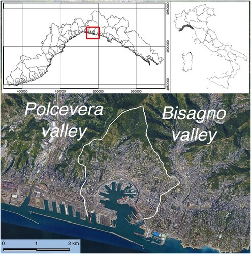
Genoa is a coastal port city of about 600,000 residents, capital of a metropolitan area of about 1.5 million inhabitants and 4165 km² of surface area ().
Figure 1. Location of the study area within Genoa city, Liguria Region, Italy.
The history of Genoa is linked to the navy and commerce: the port of Genoa is one of the largest in the Mediterranean. The city is home to shipyards and steel mills since the nineteenth century and its financial sector dates back to the Middle Ages.
For over eight centuries, the capital of the Republic of Genoa, it is known with the names of ‘The Superb’.
The oldest inhabited traces of Genoa include a small settlement ascribable to the Neolithic in the area of the current Brignole railway station, and the terraced slopes established in the ancient Bronze Age at the mouth of the Bisagno Stream (CitationArobba et al., 2018).
The historic city of Genoa originated from the Sarzano Castle, on the hill overlooking the ancient port, naturally protected by the Mandraccio peninsula. From the Middle Ages the historical centre has progressively increased around the port and in the immediate interior, where the ‘Strada Nuova’ (‘new Street’, built in the sixteenth century; now Garibaldi Street), and the subsequent ‘Via Nuovissima’ (‘Newest Street’, built at the beginning of the seventeenth century; now Balbi Street) represented for years the northern limit of the city (CitationBarbieri, 1938; CitationGrossi Bianchi & Poleggi, 1980).
2.2. Geology
The geological setting of the area (; ) is characterized by heterogeneous Flysch belonging to the Antola and Ronco Tectonic Units (Cretaceous) and by Pliocene clays deposits (CitationAPAT, 2008).
Figure 2. Geological sketch of the study area. Legend: 1. Fills; 2. Fluvial deposits; 3. Marly clays, marls, siltstones and sandstone in thin layers (Ortovero Clays, Pliocene); 4. Marly limestones, marls, siltstones in thick beds, with shales interlayers (M. Antola Formation, Cretaceous); 5. Shales in thin layers (Montoggio Argillites, Cretaceous); 6. Sandstones, marly siltstones and shales in thin layers (Ronco Formation, Cretaceous); 7. Shales and silty shales with sandstones interlayers (Montanesi Argillites, Cretaceous); 8. Bed attitude; 9. Fault; 10. Edge of marine terrace; 11. Edge of quarry scarp.
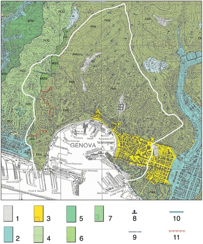
Table 1. Correspondence between lithologic units, landforms and deposits of the Main Map and units of the geological map by CitationLimoncelli and Marini (1969) and CitationAPAT (2008).
The Antola Unit is represented by the Monte Antola formation, characterized by marly limestone and marls with shales interlayers. At the base of the Antola unit, the Montoggio argillites (clayey shales) rarely outcrop in the Western sector of the studied area.
Despite of its numerous ductile and brittle deformations, at the scale of the whole slope the Antola Unit maintains a general SE dipping attitude, with an average dip angle of 45°. The Ronco Unit, represented by the homonymous formation, is made by siltstones, marly siltstones and shales. It outcrops along the Western watershed between the Genoa morphological amphitheatre and the Polcevera Valley (CitationSacchini et al., 2018).
The Pliocene deposits are represented by the Ortovero clays, a compound unit consisting of fine sands, siltstones, marls and grayish marly clays. The Ortovero clays unit outcrops in the historical centre of Genoa, in a general structural setting characterized by small graben delimited by faults, sub-parallel to the coast ().
2.3. Physical geography
The studied area covers the natural ‘morphological amphitheatre’ where the historical city has developed over the centuries (CitationBrandolini et al., 2018); the territory is delimited by the walls of 1626 CE, which mark the watershed between the Lanterna and Granarolo to the West and the Righi to the East. The maximum altitude of the studied area reaches 496 m at the Sperone Fortress, about 3 km from the coastline. The slope angle varies between 20° and 40°, whether only near the coastal strip it shows lower values than 10°.
Within this territory, several small drainage basins (total area between 0.45 and 2.36 km2) have been represented in the ‘Genova Zero’ map (CitationBarbieri, 1938) whose streams nowadays flow widely covered by urbanization (); from W to E: Dinegro, San Teodoro, Lagaccio, Sant'Ugo, Carbonara, Sant'Anna and Torbido streams. The two main rivers of the city of Genoa flow outside the studied area: the Polcevera river to the West and the Bisagno one to the East.
Genoa has a Mediterranean climate, with dry and hot summers, relatively mild winters and rainfall mainly concentrated in spring and autumn. The mean annual temperature is 15.8 °C, the annual rainfall is 1268 mm, with a total of 101 rainy days (precipitation >1 mm) per year (CitationSacchini et al., 2012). The rains are particularly concentrated in the autumn period, during which short-lived and intense precipitation phenomena are recurring due to the Genoa Low Depression, often causing severe geomorphological hazards, such as flash flood and shallow landslides (CitationAcquaotta et al., 2019; CitationPaliaga et al., 2019a).
Within the current Genoa historical centre, the unravelling of the geomorphological setting is rather difficult due to the overlap of several phases of urban development in the last millennium. A diversity of anthropic landforms characterizes the current urban landscape, previously shaped by different geomorphic agents (namely those of coastal, fluvial, and gravitational environments) of both erosional and depositional character, thus giving Genoa a complex morphostratigraphic setting.
Therefore, for the enhanced reconstruction of the geomorphological setting and evolution of the historical centre of Genoa, a preliminary analysis of available data on the geology of old city centre was necessary to enhance the application of an integrated approach including classical geomorphological mapping and historical geography,
3. Methods
The large-scale geomorphological map of historical Genoa summarizes the results of a multiple-stage research project: preliminary analysis of Earth Science knowledge from scientific and technical literature, multi-temporal comparison of historical photographs and topographic maps, and detailed field surveys and observations on site.
3.1. Literature and cartographic background
The research started by analysing and using all the existing geological and geomorphological information concerning the historical city of Genoa. Geological maps were available both from the Portal of the Italian Geological Survey of Italy and the dataset of the Genoa urban plan (CitationComune di Genova, 2014). Other very useful information came from the boreholes database of the Liguria Region, whose stratigraphic logs allowed both precise interpretations of the nature of bedrock and shallow deposits, and quantitative assessment of the thickness of the superficial deposits, at the seaside and along the slopes. The original stratigraphic logs have been re-interpreted by classifying them according to the different thickness of the fill, and also by identifying the presence of voids in the underground and of buried artefacts (typically, old walls).
Several sources for geomorphological knowledge have been taken into consideration. Geomorphological maps were analysed from the basin plan for the reduction of geo-hydrological risk (CitationAutorità di Bacino Regionale, 2019), from the urban plan of Genoa (CitationComune di Genova, 2014), and from Earth science literature (CitationBrandolini et al., 1996). Among the numerous articles consulted, both the geological observations by CitationLimoncelli and Marini (1969) and the paper by CitationRovereto (1938) on ‘Genoa and the urban geomorphology’ deserve particular mention.
3.2. Multi-temporal comparison of historical photographs and topographic maps
The multi-temporal analyses started on historical cartographic material, whose comparison was aimed at the reconstruction of the geomorphological landscape pre-dating the nineteenth-century urbanization.
Analyses were mainly addressed at the recognition and georeferenced mapping of ancient and recent excavation, historical quarries, tunnels and caves, modifications to the hydrographical network, landfills at the seaside, aqueducts and historical walls. Here below, a list of the most relevant maps and complementary materials we have consulted and used:
– documentation from the Italian Military Geographical Institute historical archive (original field survey maps of the Sardinian States, 1815-1827, 1:9450 in scale; topographic maps of the 1878–1939 period, 1: 25,000 in scale);
– the map of Genoa by Ignazio Porro (1836), 1:2000 in scale;
– the maps of the Napoleonic cadastre (1805–1814);
– the map of Genoa by Michele Poggi (1898);
– the work by Piero Barbieri (1938); the map, consisting of 24 tables 1:10,000 in scale, illustrates the expansion of Genoa and its walls from the hypothetical ‘year zero’ (before human settlement in the area) until 1938.
Analyses of aerial photos allowed to locate and to interpret geomorphological features of the study area, particularly those from images taken by historical flights between the 1930s and 1990s:
– the oldest air strip over Genoa urban area, taken by the Italian Military Geographic Institute on 1935;
– the Second World War flights by the Royal Air Force on 1944;
– the air strip on Genoa area included in National Flight by Gruppo Avieri Italiani (1954);
– images from the Regione Liguria regional flights 1973-1974, and
– various images for the local flights on Genoa area: 1983, 1993 and 2003.
Remote interpretation of current geomorphological landscape has been performed by means of analyses of Google Earth pro images, up to year 2019.
3.3. Detailed field surveys and observations on site
Methods and results of geomorphological analyses have been adapted to the dissimilar degree of urbanization of different sectors within the study area.
Within the upper part of the Genoa morphological amphitheatre, particularly in the S. Ugo, Lagaccio and S. Lazzaro drainage basins, natural conditions allowed recognition and mapping of gravity-induced landforms, fluvial landforms (natural and modified) and karst (or pseudokarst) landforms, and interpretation of their state of activity.
Field surveys were supported by multi-temporal aerial photointerpretation. For the classification and mapping of these landforms, we followed the guidelines published by the Italian National Geological Survey in collaboration with the Italian Association of Physical Geography and Geomorphology (CitationCampobasso et al., 2018; CitationMastronuzzi et al., 2017).
On the lower part of the Genoa morphological amphitheatre, a completely urbanized area, on-site geomorphological observations were carried out, aimed at identifying and mapping the main changes in the urban territory (e.g. excavations for building constructions, fills and embankments); the observations were supported by both multi-temporal cartographic comparisons and interpretation of points data derived from the regional geognostic survey database. These data, in addition to further bibliographic information on linear elements (e.g. development of tunnels), or point ones (e.g. tanks serving buildings in the historic centre) allowed enhanced knowledge and mapping of anthropogenic landforms. For these latter, we adopted the recent Italian legend for geomorphological mapping (CitationCampobasso et al., 2018) and classified its items in the conceptual framework on artificial (man-made) ground by the British Geological Survey (CitationRosenbaum et al., 2003).
The British scheme provides 5 classes of man-made ground, based on the interpretation of their constituent materials and evolutionary history of the artificial landforms: (a) made ground; (b) worked ground; (c) infilled ground; (d) disturbed ground; (e) landscaped ground. Landforms from all these five classes have been identified in the Old City of Genoa, while the ‘worked underground’ class has been introduced to differentiate the numerous underground works. Within these classes we have included the individual corresponding landform types (both erosional and depositional ones) proposed by CitationCampobasso et al. (2018) for the Italian country.
Both the natural and artificial modifications of the drainage network have been maintained between the ‘fluvial and denudational landforms’, as it was preferred to keep evident the main natural modelling process.
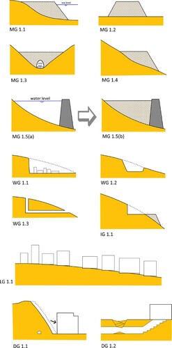
An overview of the main types of man-made landforms within Genoa is presented in .
Figure 3. Summary of the main types of man-made ground within the Genoa old city (modified from CitationEdgeworth et al., 2015; CitationRosenbaum et al., 2003). Legend: MG=Made Ground: 1.1. a sea embankment (e.g. Fig. 6); 1.2. a road or railway embankment; 1.3. a filling on valley floor with culvert (e.g. Fig. 4), 1.4. a filling on the slope (a road), 1.5(a) a dam and 1.5(b) a subsequent filling (e.g. fig. 8). WG=Worked Ground: 1.1 a cut of a slope (e.g. Fig. 7); 1.2. a road trench; 1.3. a tunnel and lift. IG=Infilled Ground: 1.1. a road along the slope (e.g. Fig. 4). LG=Landscaped Ground: 1.1. re-profiling of topography within Genoa Old city. DG=Disturbed Ground: 1.1. the Via Digione Case Study (a man-induced landslide), 1.2. Anthropogenic sinkhole due to the collapse of a II World War air raid shelter.
All collected data were geo-referenced and processed by using a Geographic Information System. The spatial reference of the map and figures is ED50, UTM projection, Zone 33 N.
4. Results: the geomorphological map of Genoa Old City
4.1. Gravity-induced landforms
Although the morphological amphitheatre of Genoa has an urban use of about 50% of the total area, several significant gravitational landforms have been recognized.
In the upper NW sector of the studied area, at the divide with the Polcevera Valley, an active rotational slide, affects some buildings and minor road at the landslide toe.
In the upper basin of the Lagaccio Stream, on the right side of the river between 200 and 400 m asl, an area characterized by many geomorphological indicators (i.e. bulging at the foot of the slope, counterscarp in the upper slope, anomalies of the drainage network) of a Deep-seated Gravitational Slope Deformation (DSGSD) can be observed along the South-Eastern slope of the Begato Fort. Within this DSGSD, the caves described in the following paragraph, are set on tension cracks probably reactivating previous tectonic discontinuities. In this part of Ligurian Apennine neotectonic uplift, glacio-eustatic oscillation and the heterogeneity of the rock mass are described as the conditioning factors of the DSGSD (CitationSacchini et al., 2016, Citation2015).
On the occasion of intense and short rains, as those of the autumn 2014 (CitationFaccini et al., 2015b), shallow landslides are triggered in the upper parts of the basins of the Lagaccio and Dinegro streams. In similar conditions, slope instabilities affect retaining walls and other elements of artificial ground within the urbanized area.
The most important landslide within the study area has been recognized at the Collina degli Angeli (‘Angels Hill’, via Digione), where the landslide scarp of year 1968 is still visible today. Due to its anthropogenic causes, this slope instability phenomenon is presented further on the paper, within the disturbed ground category (see , DG1.1. example).
4.2. Fluvial and denudational landforms
The drainage network of the Genoa morphological amphitheatre is characterized by 7 main streams, with 24 km total length of fluvial segments and medium-high slope gradients, between 30% and 40%. Even if the early development of the city adapted to the geomorphological and hydrographical conditions, over time and particularly since the Middle Ages, Man has drastically modified the natural riverbeds. In fact, more than 70% of the current watercourses have been regulated: narrowed, rectified, cemented and culverted (CitationBrandolini et al., 2018; CitationLuino et al., 2019; CitationMandarino et al., 2020; CitationPiana et al., 2019).
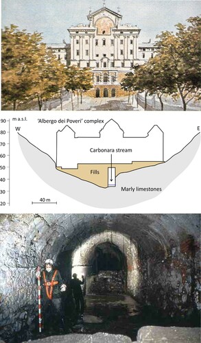
The drainage network, with the exception of the upper parts of the basins where streams still flow open air, is now invisible because it is completely covered by roads and buildings. The underground canalization of watercourses was carried out through the construction of artificial sections in bricks, blocks of stone and cement, with dimensions up to 5 m in width and 7 m in height as in the case of the Carbonara stream (; CitationBixio et al., 2017). The urbanization has also caused drastic deviations of streams, as in the case of the S. Gerolamo stream: in the thirteenth century, it was ‘artificially captured’ by the Carbonara stream. Downstream from the capture, the abandoned stretch of the S. Gerolamo stream was in turn subsequently covered and used as a drainage channel for wastewaters.
Figure 4. The ‘Albergo di Poveri’ Complex built over the Carbonara stream: the main facade of the building in a watercolour by the painter Luigi Garibbo (XIX C); Carbonara valley geomorphological cross-section; Carbonara culvert stream under the ‘Albergo dei Poveri’ Complex.
4.3. Karst and pseudo-karst landforms
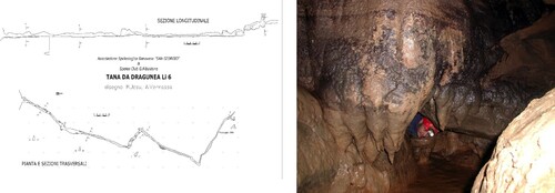
Within the upper sector of the study area (between 300 and 400 m asl), two natural caves are listed in the Ligurian speleological cadastre (CitationFaccini et al., 2012): the Upper Cave of the Dragonara and the Tanna da Dragunea (CitationSacchini et al., 2018).
The Upper Cave of the Dragonara is a small cavity (14 m of length) whose planar characteristics, anomalous altimetry and hypogeal associated landforms, and, lack of dissolution evidences, suggest a pseudo-karst origin due to mass movement (gravity, tectonic) (sensu CitationCigna, 1978 and CitationGrimes, 2011).
The Tanna da Dragunea is a cave of about 200 m of total length. The cave is a rather narrow gallery set along two tectonic discontinuities with orthogonal trends: NNE-SSW (the main one in terms of length) and WNW-ESE directions (). Karst processes are active here and at about half of the cave length, there is a siphon that can be only explored in dry periods. Given the internal morphology and the presence of typical calcareous sinter deposits (stalactite, stalagmite, columns, moonmilk and drapery), it can be assumed that the cave is indeed of karst origin, even if the structural/tectonic conditioning factor is evident: bedrock structural discontinuities have a similar setting of those characterizing the Begato mountain slope deformation.
Figure 5. Layout, section and internal image of the Tanna da Dragunea cave (from Ligurian Speleological Cadastre).
4.4. Natural and modified coastal landforms
Before the construction of the harbour, the former coastline bordering the Porto Antico bay (total length 2.5 km), was characterized by small pebbly beaches – located at the mouth of the main streams draining the surrounding morphological amphitheatre – alternating with prevalent stretches of rocky coast (CitationLimoncelli & Marini, 1969; CitationRovereto, 1938). Even if strongly reworked by the anthropogenic modifications, relict coastal terraces can be recognized along the slopes at discrete elevations of about 45, 75–80 and 90–100 m asl, which have several occurrences in other parts of the Ligurian coastline.
The terraces at lower altitudes have been interpreted as post-Pliocene erosional landforms, as they cut the Pliocene marls (CitationBrandolini et al., 1996); lack of associated deposits prevented more precise dating.
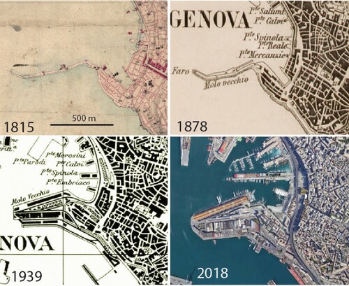
During development of Genoa harbour from the Middle Ages, several phases of landfill accumulation at the seaside progressively entailed an advancement of the shoreline and a consequent narrowing of the bay. The oldest archaeological finding of the port is a quay made of marly limestone blocks, attributed to the twelfth century, at the current ‘Old Pier’, Eastern sector of the bay (CitationBrandolini et al., 2007). In the Seventeenth century, large landfills were made along the Western sector of the bay with the construction of the ‘New Pier’ and in the central area with the creation of a new sea embankment where the S. Giorgio palace and the ‘Magazzini del Cotone’ were built (). At the beginning of the twentieth century, further port expansions occurred at sea, which almost closed the entrance of the bay in the eastern sector, up to the bathymetry of about 15 m.
Figure 6. Historical cartographic and photographic comparison of the piers of the ancient port.
4.5. Man-made landforms
In addition to the modifications of the hydrographic network and of the coastline described above, numerous anthropic interventions have affected the historic centre of Genoa: these are consequent on the expansion of the settlements, the infrastructures and the quarrying activities.
The human agency in the geomorphological landscape of Genoa caused important morphological transformations of large sectors of the slopes, of the valley bottoms and also of the small fluvial-coastal plains within the studied area. Anthropogenic landforms have also been identified in the underground.
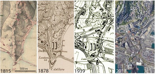
The most important example of an anthropogenic erosional landform is represented by the progressive excavation of the terminal part of the Promontory of San Benigno: first (centuries eighteenth-nineteenth century) for open pit quarrying, then (beginning of the twentieth century) for the city road expansion towards W (). We can estimate an excavation equal to 12 million cubic meters of marly limestone, which were used both as building and filling materials for the new port areas (CitationRovereto, 1938).
Figure 7. Historical cartographic and photographic comparison of the Promontory of San Benigno.
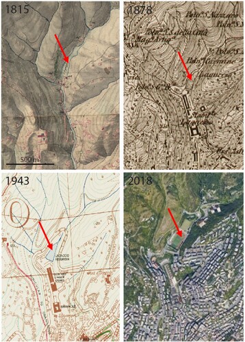
Particularly relevant examples of anthropogenic landforms due to accumulation are the valleys fillings: (i) the middle stretch valley of the Lagaccio Stream, during the seventeenth century was affected by the construction of a dam for creating an artificial lake. This lake has gradually been buried by natural sedimentation. In 1970 its reclamation was completed with artificial fillings, creating an area for recreational and sports activities (); (ii) similarly, during the seventeenth century, the middle stretch of the Carbonara Stream valley was filled with about one million cubic meters of debris with the creation of a flat area of 8 ha, where an hospital complex (‘Albergo dei Poveri’) was built ().
Figure 8. Historical cartographic and photographic comparison of the piers of the Lagaccio Stream valley
The construction of the railway line in the second half of the nineteenth century entailed profound morphological modifications of the terminal stretches of the valleys of the Sant'Ugo Stream and of the Carbonara Stream, due to surface and underground excavation, and filling interventions, for obtaining the large flat area where the ‘Principe’ Railway Station was built. This project also caused further total coverage of the two streams.
Similarly, for the development of the new road network (‘Via Roma’, ‘Via Cairoli’ and ‘Via Balbi’), large open-pit excavations were created in the sixteenth–seventeenth century, affecting marly-limestone (Cretaceous) and marls (Pliocene) bedrocks. In the same period, the tunnels of ‘Castelletto’ and ‘Villetta di Negro’ were built, connecting Piazza Corvetto and Piazza Portello, for a total length of 475 m. Other numerous underground excavations are due to tunnels and wells for the construction of the elevators connecting the low and middle parts of the city with a difference in altitude in the order of 40–50 m. The nineteenth–twentieth centuries settlement expansion along the steep slopes also caused large excavations and filling on the slopes, with the construction of cyclopean retaining walls, with heights up to 20/30 m ().
Within this ‘quarry’ context, on 1931 a house was built at n. 8 of Via Digione on the square of a marly limestone quarry that was abandoned in 1909 due to slope instability (CitationPeretti, 1969). Following heavy rains, at 6 pm on March 21, 1968, a 5m-thick slab of rock (volume of about 15,000 m3), detached from the quarry scarp and hit the base of the building, provoking the collapse of part of the building. The landslide caused 19 victims and displaced persons.
5. Final remarks and conclusion
The results of a multi-year survey and archive research allowed reconstructing the geomorphological condition of the Genoa old city. The historic Maritime Republic of Genoa includes many internationally-known cultural sites, but also geomorphological and geological features. The research has allowed the preparation of a geomorphological map, useful for highlighting the overlap of urban fabric, geographic-physical structure, and geomorphological processes. The unique characteristics of the coastal territory of Genoa, affected by continuous anthropogenic changes from the Middle Ages, required innovative solutions for the geomorphological reconstruction within the urban environment and its consequent mapping.
Therefore, we developed and tested an integrated methodology for urban geomorphological studies, including field surveys and on-site observations, cartographic comparisons and multi-temporal photographs, careful analysis of geological, geomorphological, hydrogeological, geo-archaeological and historical-architectural literature. The adopted methodological framework can contribute to geomorphological analysis in other urban coastal areas of Mediterranean territories similar to Genoa: the proposed legend for man-made landforms presents many original entries compared to both current national (Italy) and international standards for urban geomorphological mapping. The proposed symbols derive from the analysis of the historic centre of Genoa, which is characterized by the overlap of various phases of the city's expansion: the result highlights a significant transformation of the urban geomorphological landscape.
In conclusion, the large-scale geomorphological map represents not only a tool for comprehensive, retrospective analyses of the geomorphological characteristics of the historic centre of Genoa within the area bounded by the seventeenth century wall; it can be also considered a useful reference map for proper present-day urban planning and future geoheritage enhancement. In fact, the detailed inventory and mapping of anthropogenic and natural landforms modified by human intervention, follows the most recent directions for of cultural heritage protection and geo-hydrological risk reduction within an area affected by severe climate change effects (CitationAcquaotta et al., 2019, Citation2018; CitationBrandolini et al., 2018; CitationDel Monte et al., 2015; CitationLuberti et al., 2015).
Software
All data processing necessary to produce the map were performed using ARCGIS 10.6. The layout used for creating the A0 map layout was also produced using ARCGIS 10.6. The figures in the paper were created using PAINT.NET. New vector symbology and some symbol modifications were generated using Adobe ILLUSTRATOR CC 2015. The final map layout was processed using Adobe ILLUSTRATOR CC 2015.
TJOM_1777214_Main Map
Download PDF (61.9 MB)Disclosure statement
No potential conflict of interest was reported by the author(s).
References
- Acquaotta, F., Faccini, F., Fratianni, S., Paliaga, G., & Sacchini, A. (2018). Rainfall intensity in the Genoa metropolitan area: Secular variations and consequences. Weather, 73(11), 356–362. https://doi.org/10.1002/wea.3208
- Acquaotta, F., Faccini, F., Fratianni, S., Paliaga, G., Sacchini, A., & Vilìmek, V. (2019). Increased flash flooding in Genoa metropolitan area: A combination of climate changes and soil consumption? Meteorology and Atmospheric Physics, 131(4), 1099–1110. https://doi.org/10.1007/s00703-018-0623-4
- APAT, Regione Liguria. (2008). Foglio 213230 ‘Genova’ della Carta Geologica d'Italia alla scala 1:50.000 [Sheet n. 213230 ‘Genova’ of the Italian Geological Map at1:250.000 scale]. Selca Editore, Firenze. http://www.isprambiente.gov.it/Media/carg/213_GENOVA/Foglio.html
- Arobba, D., Caramiello, R., Firpo, M., Mercalli, L., Morandi, L. F., & Rossi, S. (2018). New evidence on the earliest human presence in the urban area of Genoa (Liguria, Italy): A multi-proxy study of a mid-Holocene deposit at the mouth of the Bisagno river. The Holocene, 28(12), 1918–1935. https://doi.org/10.1177/0959683618798107
- Autorità di Bacino Regionale. (2019). Piano di Bacino Stralcio per l’assetto Idrogeologico, Ambito 14, [Basin Master Plan for the Geo-hydrological risk reduction]. http://www.pianidibacino.ambienteinliguria.it/GE/ambito14/ambito14.html
- Barbieri, P. (1938). Forma Genuae. Ed. Municipio di Genova.
- Bathrellos, G.D. (2007, May 24–26). An overview in urban geology and urban geomorphology. Proceedings of the 11th international Congress, Athens, Bulletin of the Geological Society of Greece, XXXX, 1354-1364.
- Bixio, R., Faccini, F., Maifredi, A., Perasso, L., Saj, S., & Traverso, M. (2017). The culverted streams in the historical amphitheatre of Genoa city (Italy): Flood risk or geoheritage protection? In Hypogea 2017, Proceedings of International Congress of Speleology in Artificial Cavities, Cappadocia, Turkey, 2017 March 6-10, 165-176.
- Bollati, I., Coratza, P., Giardino, M., Laureti, L., Leonelli, G., Panizza, M., Panizza, V., Pelfini, M., Piacente, S., Pica, A., Russo, F., Zerboni, A. (2015). Directions in geoheritage studies: Suggestions from the Italian geomorphological Community. In G. Lollino, D. Giordan, C. Marunteanu, B. Christaras, I. Yoshinori, C. Margottini (Eds.), Engineering geology for Society and territory, vol. 8 ‘preservation of cultural heritage’ (pp. 213–217). Springer.
- Brandolini, F., Cremaschi, M., & Pelfini, M. (2019a). Estimating the potential of archaeo-historical data in the definition of geomorphosites and geo-educational itineraries in the central Po plain (N Italy). Geoheritage, https://doi.org/10.1007/s12371-019-00370-5
- Brandolini, P. (2017). The outstanding terraced landscape of the Cinque Terre coastal slopes (Eastern Liguria). In M. Soldati & M. Marchetti (Eds.), Landscapes and landforms of Italy, World geomorphological Landscapes (pp. 235–244). Springer International Publishing.
- Brandolini, P., Cappadonia, C., Luberti, G. M., Donadio, C., Stamatopoulos, L., Di Maggio, C., Faccini, F., Stanislao, C., Vergari, F., Paliaga, G., Agnesi, V., Alevizos, G., & Del Monte, M. (2019b). Geomorphology of the Anthropocene in Mediterranean urban areas. Progress in Physical Geography: Earth and Environment, https://doi.org/10.1177/0309133319881108
- Brandolini, P., Cevasco, A., Firpo, M., Robbiano, A., & Sacchini, A. (2012). Geo-hydrological risk management for civil protection purposes in the urban area of Genoa (Liguria, NW Italy). Natural Hazards and Earth System Sciences, 12(4), 943–959. https://doi.org/10.5194/nhess-12-943-2012
- Brandolini, P., Faccini, F., Paliaga, G., & Piana, P. (2017). Urban geomorphology in coastal environment: Man made morphological changes in a seaside tourist resort (Rapallo, Eastern Liguria, Italy). Quaestiones Geographicae, 36(3), 97–110. https://doi.org/10.1515/quageo-2017-0027
- Brandolini, P., Faccini, F., Paliaga, G., & Piana, P. (2018a). Man-Made landforms identification and mapping in an highly urbanized historical centre on coastal-hilly Mediterranean environment. Geografia Fisica e Dinamica Quaternia, 41(1), 23–34. https://doi.org/10.4461/GFDQ.2018.41.2
- Brandolini, P., Faccini, F., Robbiano, A., & Terranova, R. (2007). Geomorphological hazard and monitoring activity in the western rocky coast of the Portofino Promontory (Italy). Quaternary International, 171-172, 131–142. https://doi.org/10.1016/j.quaint.2006.11.006
- Brandolini, P., Firpo, M., Marini, M., Piccazzo, M., Ramella, A., & Terranova, R. (1996). Osservazioni Preliminari sull'Evoluzione Quaternaria dell'Area del Porto Vecchio di Genova. Il Quaternario, 9(1), 375–380.
- Brandolini, P., Pepe, G., Capolongo, D., Cappadonia, C., Cevasco, A., Conoscenti, C., Marsico, A., Vergari, F., & Del Monte, M. (2018b). Hillslope degradation in representative Italian areas: Just soil erosion risk or opportunity of development? Land Degradation & Development, 29(9), 3050–3068. https://doi.org/10.1002/ldr.2999
- Brown, A. G., Tooth, S., Bullard, J. E., Thomas, D. S. G., Chiverrell, R. C., Plater, A. J., Murton, J., Thorndycraft, V. R., Tarolli, P., Rose, J., Wainwright, J., Downs, P., & Aalto, R. (2017). The geomorphology of the Anthropocene: Emergence, status and implications. Earth Surface Processes and Landforms, 42(1), 71–90. https://doi.org/10.1002/esp.3943
- Cafiso, F., & Cappadonia, C. (2019). Landslide inventory and rockfall risk assessment of a strategic urban area (Palermo, Sicily). Rendiconti Online Della Società Geologica Italiana, 48, 96–105. https://doi.org/10.3301/ROL.2019.42
- Campobasso, C., Carton, A., Chelli, A., D’Orefice, M., Dramis, F., Graciotti, R., Guida, D., Pambianchi, G., Peduto, F., & Pellegrini, L. (2018). Aggiornamento ed integrazioni delle Linee guida della Carta geomorfologica d’Italia alla scala 1:50.000. Progetto CARG: Modifiche ed Integrazioni al Quaderno n. 4/1994. Quaderni Serie III, 13(1).
- Cappadonia, C., Coratza, P., Agnesi, V., & Soldati, M. (2018). Malta and Sicily joined by geoheritage enhancement and geotourism within the framework of land management and development. Geosciences, 8(7), 253. https://doi.org/10.3390/geosciences8070253
- Cigna, A. (1978). A classification of karst phenomena. International Journal of Speleology, 10(1), 3–9. https://doi.org/10.5038/1827-806X.10.1.1
- Cimmino, F., Faccini, F., & Robbiano, A. (2004). Stones and coloured marbles of Liguria in historical monuments. Periodico di Mineralogia, 73((Special Issue 3: a showcase of Italian research in applied petrology)), 71–84.
- Comune di Genova (2014). Piano Urbanistico Comunale, progetto definitivo: descrizione fondativa (carta geologica, geomorfologica, idrogeologica). [City council urban plan, definitive design: technical report and geological maps]. http://puc.comune.genova.it/elaborati.asp
- Cooke, R. U., Brunsden, D., Doornkamp, J. C., & Jones, D. K. C. (1982). Urban geomorphology in drylands. Oxford University Press.
- Del Monte, M., D’Orefice, M., Luberti, G. M., Marini, R., Pica, A., & Vergari, F. (2016). Geomorphological classification of urban landscapes: The case study of Rome (Italy). Journal of Maps, 12(sup1), 178–189. https://doi.org/10.1080/17445647.2016.1187977
- Del Monte, M., Vergari, F., Brandolini, P., Capolongo, D., Cevasco, A., Ciccacci, S., Conoscenti, C., Fredi, P., Melelli, L., Rotigliano, E., Zucca, F. (2015). Multi-method evaluation of denudation rates in small Mediterranean catchments. In G. Lollino, A. Manconi, & J. Clague (Eds.), Engineering geology for Society and territory, climate change and Engineering geology (Vol 1, pp. 563–567). Springer International Publishing.
- Diao, C. (1996). An approach to theory and methods of urban geomorphology. Chinese Geographical Science, 6(1), 88–95. https://doi.org/10.1007/s11769-996-0039-9
- Donadio, C. (2017). Experimenting criteria for risk mitiga- tion in fluvial-coastal environment. CSE Journal – City Safety Energy, 1, 9–14.
- Edgeworth, M., Richter, D. B., Waters, C., Haff, P., Neal, C., & Price, S. J. (2015). Diachronous beginnings of the anthropocene: The lower bounding surface of anthropogenic deposits. The Anthropocene Review, 2(1), 33–58. https://doi.org/10.1177/2053019614565394
- Ellison, R. A., Booth, S. L., & Strange, P. J. (1993). Geological mapping in urban areas. Episodes, 16(3), 383–387. https://doi.org/10.18814/epiiugs/1993/v16i3/003
- Eyles, N. (1997). Environmental geology of urban areas. Geological Association of Canada. Geotext 3.
- Faccini, F., Benedettini, A., Firpo, M., Perasso, L., & Poggi, F. (2012). Land-management and planning in karst areas: The ligurian case-study (Italy). Rendiconti On-Line Societa Geologica Italiana, 21, 611–613.
- Faccini, F., Luino, F., Paliaga, G., Sacchini, A., & Turconi, L. (2015b). Yet another disaster flood of the Bisagno stream in Genoa (Liguria, Italy): October the 9th-10th2014 event. Rendiconti On-Line Societa Geologica Italiana, 35, 128–131. https://doi.org/10.3301/ROL.2015.81
- Faccini, F., Luino, F., Paliaga, G., Sacchini, A., Turconi, L., & de Jong, C. (2018). Role of rainfall intensity and urban sprawl in the 2014 flash flood in Genoa city, Bisagno Catchment (Liguria, Italy). Applied Geography, 9(8), 224–241. https://doi.org/10.1016/j.apgeog.2018.07.022
- Faccini, F., Luino, F., Sacchini, A., Turconi, L., & De Graff, J. V. (2015a). Geo-hydrological hazard and urban development in the Mediterranean area: An example from Genoa city (Italy). Natural Hazard and Earth System Science, 15(12), 2451–2492. https://doi.org/10.5194/nhess-15-2631-2015
- Faccini, F., Paliaga, G., Piana, P., Sacchini, A., & Watkins, C. (2016). The Bisagno stream catchment (Genoa, Italy) and its major floods (1822, 1970 and 2014): geomorphic and land use variations in the last three centuries. Geomorphology, 273, 14–27. https://doi.org/10.1016/j.geomorph.2016.07.037
- Faccini, F., Piccazzo, M., Robbiano, A., & Roccati, A. (2008). Applied geomorphological map of the Portofino municipal territory (Italy). Journal of Maps, 4(1), 451–462. https://doi.org/10.4113/jom.2008.1023
- Giardino, M., Lombardo, V., Lozar, F., Magagna, A., Perotti, L. (2015a). Geomedia-web: Multimedia and networks for dissemination of knowledge on geoheritage and natural risk Engineering geology for Society and territory. In G. Lollino, M. Arattano, M. Giardino, R. Oliveira, S. Peppoloni (Eds.), Education, Professional Ethics and Public recognition of Engineering geology (Vol 7, pp. 146–150). Springer International Publishing Switzerland.
- Giardino, M., Mortara, G., Borgatti, L., Nesci, O., Guerra, C., Lucente, C. (2015b). Dynamic geomorphology and historical Iconography. Contributions to the knowledge of environmental changes and slope instabilities in the Apennines and the Alps. In G. Lollino, D. Giordan, C. Marunteanu, B. Christaras, I. Yoshinori, C. Margottini (Eds.), Engineering geology for Society and territory, vol. 8 ‘preservation of cultural heritage’ (pp. 463–468). Springer International Publishing Switzerland.
- Grimes, K.G. (2011, April 17–22). The terminology of karst, parakarst, pseudokarst, and ruiniformlandscapes. Abstract & Poster presented at the 28th conference of the Australian Speleological Federation, Chillagoe, 2011.
- Grossi Bianchi, L., & Poleggi, E. (1980). Una città portuale del medioevo. Genova nei secoli X-XVI. Sagep Ed.
- Huggenberger, P., & Epting, J. (2011). Urban geology. Process-oriented concept for Adaptive and integrated Resource management. Springer.
- Lanza, S. G. (2003). Flood hazard threat on cultural heritage in the town of Genoa (Italy). Journal of Cultural Heritage, 4(3), 159–167. https://doi.org/10.1016/S1296-2074(03)00042-6
- Limoncelli, B., & Marini, M. (1969). Condizioni geologico-strutturali, idrografiche e geomorfologiche del territorio urbano della città di Genova e loro riflessi applicativi [geology, hydrography and geomorphology of Genoa city and applied analysis]. Tamburini ed.
- Luberti, G. M. (2018). Computation of modern anthropogenic-deposit thicknesses in urban areas: A case study in Rome. The Anthropocene Review, 5(1), 2–27. https://doi.org/10.1177/2053019618757252
- Luberti, G. M., Prestininzi, A., & Esposito, C. (2015). Development of a geological model useful for the study of the natural hazards in urban environments: An example from the eastern sector of Rome (Italy). Italian Journal of Engineering Geology and Environment, 2, 41–62. https://doi.org/10.4408/IJEGE.2015-02.O-04
- Luberti, G. M., Vergari, F., Pica, A., & Del Monte, M. (2019). Estimation of the thickness of anthropogenic deposits in historical urban centres: An interdisciplinary methodology applied to Rome (Italy). The Holocene, 29(1), 158–172. https://doi.org/10.1177/0959683618804630
- Lucchesi, S., Giardino, M. (2015). Historical Archives data for the reconstruction of geomorphological modifications in the urban area of Turin (NW-Italy). In G. Lollino, D. Giordan, C. Marunteanu, B. Christaras, I. Yoshinori, C. Margottini (Eds.), Engineering geology for Society and territory, vol. 8 ‘preservation of cultural heritage’ (pp. 447–451). Springer International Publishing.
- Luino, F., Paliaga, G., Roccati, A., Sacchini, A., Turconi, L., & Faccini, F. (2019). Anthropogenic changes in the alluvial plains of the Tyrrhenian Ligurian basin. Rendiconti Online della Società Geologica Italiana, 48, 10–16. https://doi.org/10.3301/ROL.2019.31
- Mandarino, A., Pepe, G., Maerker, M., Cevasco, A., & Brandolini, P. (2020). Short-term GIS analysis for the assessment of the recent active-channel Planform Adjustments in a Widening, Highly Altered river: The Scrivia river, Italy. Water, 12(514), 1–22. https://doi.org/10.3390/w12020514
- Mastronuzzi, G., Aringoli, D., Aucelli, P. P. C., Baldassarre, M. A., Bellotti, P., Bini, M., Biolchi, S., Bontempi, S., Brandolini, P., Chelli, A., Davoli, L., Deiana, G., De Muro, S., Devoto, S., Di Paola, G., Donadio, C., Fago, P., Ferrari, M., Furlani, S., … Valente, A. (2017). Geomorphological map of the Italian coast: From a descriptive to a morphodynamic approach. Geografia Fisica e Dinamica Quaternaria, 40(2), 161–196. https://doi.org/10.4461/%20GFDQ%202017.40.11
- Paliaga, G., Faccini, F., Luino, F., & Turconi, L. (2019a). A spatial multicriteria prioritizing approach for geohydrological risk mitigation planning in small and densely urbanized Mediterranean basins. Natural Hazards and Earth System Sciences, 19(1), 53–69. https://doi.org/10.5194/nhess-19-53-2019
- Paliaga, G., Luino, F., Turconi, L., & Faccini, F. (2019b). Inventory of geo-hydrological phenomena in Genova municipality (NW Italy). Journal of Maps, 15(2), 28–37. https://doi.org/10.1080/17445647.2018.1535454%20doi:10.1080/17445647.2018.1535454
- Pepe, G., Mandarino, A., Raso, E., Scarpellini, P., Brandolini, P., & Cevasco, A. (2019). Investigation on farmland abandonment of terraced slopes using multitemporal data sources comparison and its implication on hydro-geomorphological processes. Water, 11(8), 1552. https://doi.org/10.3390/w11081552
- Peretti, L. (1969). Appunti di geologia tecnica sulla frana del 21 marzo 1968 in Genova, Collina degli Angeli. Atti Ist. Geol. Univ. Genova, 6, 189–209.
- Perotti, L., Carraro, G., Giardino, M., De Luca, D. A., & Lasagna, M. (2019). Geodiversity evaluation and water resources in the Sesia Val Grande UNESCO Geopark (Italy). Water, 11(10), 10. Article number 2102. https://doi.org/10.3390/w11102102
- Perotti, L., Dino, G. A., Lasagna, M., Moussa, K., Spadafora, F., Yadji, G., Dan-Badjo, A. T., & De Luca, D. A. (2016). Monitoring of urban growth and its related environmental impacts: Niamey case study (Niger). Energy Procedia, 97, 37–43. https://doi.org/10.1016/j.egypro.2016.10.014
- Perotti, L., Lasagna, M., Clemente, P., Dino, G. A., De Luca, D. A. (2015). Remote sensing and hydrogeological methodologies for irrigation canal water losses detection: The Naviglio di Bra test site (NW-Italy). In G. Lollino, M. Arattano, M. Rinaldi, O. Giustolisi, J.-C. Marechal, G. E. Grant (Eds.), Engineering geology for Society and territory, vol. 3: River basins, reservoir sedimentation and water resources (pp. 269–273). Springer International Publishing Switzerland.
- Piana, P., Faccini, F., Luino, F., Paliaga, G., Sacchini, A., & Watkins, C. (2019). Geomorphological landscape research and flood management in a Heavily modified Tyrrhenian Catchment. Sustainability, 11(17), 4594. https://doi.org/10.3390/su11174594
- Pica, A., Vergari, F., Fredi, P., & Del Monte, M. (2016). The AeternaUrbs geomorphological heritage (Rome. Italy). Geoheritage, 8(1), 31–42. https://doi.org/10.1007/s12371-015-0150-3
- Reynard, E., Pica, A., & Coratza, P. (2017). Urban geomorphological heritage. An Overview. Quaestiones Geographicae, 36(3), 7–20. https://doi.org/10.1515/quageo-2017-0022
- Rosenbaum, M. S., McMillan, A. A., Powel, J. H., Cooper, A. H., Culshaw, M. G., & Northmore, K. J. (2003). Classification of artificial (man-made) ground. Engineering Geology, 69(3), 399–409. https://doi.org/10.1016/S0013-7952(02)00282-X
- Rovereto, G. (1938). Genova e la geomorfologia urbanistica. Consiglio nazionale delle ricerche, Comitato per la geologia. Estratto da ‘La Ricerca Scientifica’, I, 11–12.
- Sacchini, A., Faccini, F., Ferraris, F., Firpo, M., & Angelini, S. (2015). Large-scale landslide and Deep-seated gravitational slope deformation of the upper Scrivia valley (northern Apennine, Italy). Journal of Maps, 12(2), 344–358. https://doi.org/10.1080/17445647.2015.1021393
- Sacchini, A., Faccini, F., & Luino, F. (2016). Deep seated gravitational slope deformations in a Ligurian Apennines catchment (Italy): evidences, characterizations and consequences. Disaster Advances, 9(3), 1–18.
- Sacchini, A., Ferraris, F., Faccini, F., & Firpo, M. (2012). Environmental climatic maps of Liguria. Journal of Maps, 8(3), 199–207. https://doi.org/10.1080/17445647.2012.703901
- Sacchini, A., Imbrogio Ponaro, M., Paliaga, G., Piana, P., Faccini, F., & Coratza, P. (2018). Geological landscape and stone heritage of the Genoa walls urban Park and surrounding area (Italy). Journal of Maps, 14(2), 528–541. https://doi.org/10.1080/17445647.2018.1508378
- Zwoliński, Z., Hildebrandt-Radke, I., Mazurek, M., & Makohonienko, M. (2017). Existing and proposed urban geosites values resulting from geodiversity of Poznań city. Quaestiones Geographicae, 36(3), 125–149. https://doi.org/10.1515/quageo-2017-0031
- Zwoliński, Z., Najwer, A., & Giardino, M. (2018). Methods for Assessing geodiversity. In E. Reynard & J. Brilha (Eds.), Ts.) geoheritage: Assessment, protection and management, Chapter 2 (pp. 27–52). Elsevier.