
ABSTRACT
This paper describes the anthropogenic landforms of the alluvial-coastal plain of Rapallo (Eastern Liguria, NW Italy). Since the second half of the nineteenth-century Rapallo experienced a progressive urban sprawl that became particularly intense after the Second World War and severely modified the former landforms. The identification and mapping of morphological changes was performed through a multi-temporal comparison of historical and recent maps and aerial photographs, an analysis of geo-thematic maps and urban planning documents, an interpretation of stratigraphic data from boreholes, and a field survey activity. The main anthropogenic interventions that shaped the urban landscape of Rapallo were riverbed diversions and channelization, excavations, fillings, and embankments construction along the shoreline. These elements highlight the relevant extent of the human imprint on the pristine environment. Furthermore, the identified anthropogenic geomorphological features, combined with the local physiographic and climatic features, increased flood and sea storm hazards and risks.
1. Introduction
Geomorphological mapping in urban areas is a relatively recent subject within the frame of researches concerning the Anthropocene, meant as the time period when the human influence has been overcoming natural processes on Earth and its geological record (CitationBathrellos, 2007; CitationCrutzen, 2002; CitationDel Monte et al., 2016; CitationHuggenberger & Epting, 2011; CitationSteffen et al., 2007; CitationWaters et al., 2016). Urban geomorphology is the study of human activities as a physical process of change in which human beings modify the natural landforms and transform them into an anthropogenic landscape (CitationCooke et al., 1982; CitationDiao, 1996).
Currently, in many Mediterranean areas, anthropogenic landforms are the most impacting features of the coastal landscape (CitationBrandolini et al., 2019; CitationCooper et al., 2018; CitationGoudie, 2018; CitationLuino et al., 2019).
Urban geomorphological studies can support a better perception of city development effects on geomorphological features, and their impact on geo-hydrological risk also in relation to climate change (CitationCafiso & Cappadonia, 2019; CitationGalve et al., 2016; CitationLóczy, & Süto, 2011; CitationSlaymaker et al., 2009) and contribute to the valorization of geo-heritage in urban areas (CitationCappadonia et al., 2018; CitationPica et al., 2016; CitationReynard et al., 2017; CitationRodrigues et al., 2011; CitationZwoliński et al., 2017).
Identification and mapping of geomorphic processes, landforms and deposits in urban environments are different from those targeted to natural environments where landforms are usually easier to identify (CitationEllison et al., 1993; CitationEyles, 1997). Geomorphological survey within urbanized areas is quite difficult to perform due to the progressive stratification of cities growth and the resulting obliteration of natural landforms (CitationBathrellos, 2007; CitationLuberti, 2018; CitationLuberti et al., 2019; CitationPaliaga et al., 2019).
In the twentieth century, and particularly after the Second World War, many cities went through uncontrolled urban sprawl which has been termed an ‘urban revolution’ (CitationDiao, 1996). In the Mediterranean, this was partly related to the development of tourism (CitationDonadio, 2017; CitationFaccini et al., 2008; CitationJefferson et al., 2013; CitationRoccati et al., 2019).
In the framework of these issues, the case study of Rapallo, a Mediterranean coastal- tourist city (Liguria, NW Italy), is presented and discussed. The anthropogenic landforms are described and shown by using a novel map realized according to the new experimental geomorphological legend (CitationCampobasso et al., 2018) proposed by the Working Groups of the Italian Association of Physical Geography and Geomorphology (AIGeo) and the Italian Institute for Environmental Protection and Research (ISPRA), and the British Geological Survey classification scheme for artificial ground (CitationRosenbaum et al., 2003).
The main aims of the research are, on the one hand, the exploration of the impact of historical and recent human interventions that affected the Rapallo alluvial-coastal plain and the associated shoreline on landforms and geomorphological processes, and, on the other hand, the characterization of the current geo-hydrological hazards and risks scenario.
2. Geographical setting of the study area
Rapallo is located in the eastern Liguria (NW Italy), within the Genova Metropolitan area and in the innermost sector of the Tigullio Gulf (). Since the second half of the nineteenth-century Rapallo was affected by a progressive urban sprawl that became particularly intense, following tourist development, after the Second World War, strongly modifying the former landforms of the alluvial-coastal plain and the surrounding slopes.
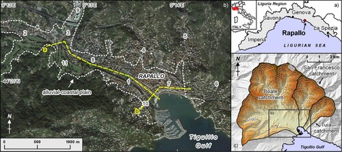
Figure 1. Location of the study area (a). The alluvial-coastal floodplain of Rapallo (b); the dashed line represents the alluvial-coastal plain limit; 1: Boate Stream, 2: Santa Maria Stream, 3: San Pietro Stream, 4: Cereghetta Stream, 5: San Francesco Stream, 6: Tuia Stream, 7: Rapallo Old Town, 8: Sant’Anna, 9: San Pietro di Novella, 10: Annibale Bridge, 11: Golf course; a and b: trace of geomorphological cross section (). The catchments upstream of Rapallo (c); the equidistance of contour lines is 100.
The area is characterized by a Mediterranean climate with dry and hot summers, relatively mild winters and abundant precipitation concentrated in autumn and spring (CitationAcquaotta et al., 2018; CitationFaccini et al., 2018; CitationSacchini et al., 2012). Between 1950 and1989 the weather station of San Pietro di Novella (13 m a.s.l.) recorded a mean annual temperature of 15°C, an average annual rainfall of 1400 mm and a mean annual value of 90 rainy days (> 1 mm). Detailed weather observations carried out in Genova’s Metropolitan Area underlined some climate trends: the mean annual temperature is increasing, the number of rainy days shows a noteworthy reduction, and the annual rainfall does not show significant changes. Thus, these trends highlight an increase in the daily rainfall intensity (CitationBrandolini, Faccini, et al., 2018; CitationBrandolini et al., 2008; CitationFaccini et al., 2015; CitationFaccini et al., 2016). Due to the physiographical features of the catchments upstream Rapallo, the urban settlement is prone to floods, such as most of Liguria Region territory (CitationPepe et al., 2019a).
The alluvial-coastal plain is formed by the alluvial deposits coming from the catchments of the Boate Stream (26 km2), San Francesco Stream (6 km2) and Tuia Stream (2,5 km2), locally reshaped by the sea.
With respect to the size of the plain and catchment, the alluvial deposits have a significant thickness (up to 25 m): the deposits are made up of a sequence of clay, silt, peat, sand and gravel. Swampy deposits with transitions between marine and fluvial domain due to sea-level oscillations in the Holocene have also been found (CitationBrandolini, 1994). Moreover, traces of some fluvial and marine terraces were found along the slopes surrounding the alluvial-coastal plain at elevations between 15 and 80 m a.s.l., alongside with triangular facets; these landforms testify the occurred base-level variations (CitationBrancucci & Paliaga, 2005; CitationPaliaga, 2015).
The setting of the plain and the nearby rocky coast follows two tectonic lineaments: (i) the main axis of the plain and the coast stretch located South-East of Rapallo follow a WNW-ESE direction; (ii) the minor tributary valleys and the coast stretch located approximately South-West of Rapallo are almost orthogonal to the previous tectonic lineament (CitationBrandolini et al., 2007; CitationFederici et al., 2019). The plain length is about 3 km, with an average width of 300-400 m and an overall surface that is approximately 1.8 km2.
From a geological point of view the area is characterized by Mt. Antola Formation, belonging to the homonymous tectonic units (Upper Cretaceous), and mainly consisting of marly limestone, occasionally silty, with thin interlayers of shale (CitationAPAT, Regione Liguria, 2008). Although the Antola Formation has been affected by several deformations, it shows a general structure characterized by overlapping layers with SW dip direction and dip angle ranging between 30° and 60° (CitationBrandolini et al., 2017; CitationCimmino et al., 2004; CitationMarini, 1981; CitationMolli et al., 2010).
The Rapallo plain is completely urbanized and adjacent slopes show cultivated terraces and overall natural and semi-natural areas resulting from the abandonment of agricultural terraces (CitationBrandolini, 2017; CitationBrandolini et al., 2018; CitationDel Monte et al., 2015; CitationPaliaga et al., 2016; CitationPaliaga et al., 2020; CitationPepe et al., 2019b; CitationRaso et al., 2019).
3. Materials and methods
The first phase of research consisted in collecting, analyzing, re-elaborating and summarizing previous geographical and geomorphological studies on the Rapallo area (CitationBallardini, 1994; CitationBrandolini, 1994; CitationCortemiglia & Terranova, 1974; CitationScarin, 1959) and all the geo-thematic documents and maps available from the Basin Master Plan and from the Rapallo Municipality Master Plan (Autorità di Bacino Regionale, Citation2017; CitationCittà Metropolitana di Genova, 2015; CitationComune di Rapallo, 2014).
The second phase of the study was based on detailed research in historical archives and a comparison of ancient, recent and current topographical maps and aerial photographs (Luino et al., Citation2016). This was aimed at a better comprehension of morphological features and landscape before the urbanization process started in the second half of the nineteenth century.
The performed analyses were mainly addressed to the recognition and mapping of excavation, quarries, tunnels, drainage network modifications, landfills at the seaside and water pipelines.
The most significant cartographic documents considered for the implementation of the present study were from the Italian Military Geographical Institute (IGMI) archive (1:9,450 scale manuscript maps from 1815 to 1827; 1:25,000 scale topographical maps from 1878 to 1939), the ‘Archivio di Stato di Genova’ (maps by Matteo Vinzoni of both the middle and late eighteenth century), the Rapallo Municipality Archive (maps dated back to the nineteenth century, early twentieth century and 1960s), and the Liguria Region Administration Archive (maps of the period 1984-2011). The interpretation of the aerial photography mainly focused on a number of images available for the period 1930s-1980s: historical survey by IGMI (1936), RAF survey (1944), Liguria Region Administration survey (1973/74). Moreover, the recent satellite images available in Google Earth were considered to investigate the current setting. The geomorphological field survey in urban environment resulted in detailed morphological observations (CitationEllison et al., 1993; CitationEyles, 1997). Furthermore, stratigraphic data derived from the regional boreholes database were used to provide further information concerning the superficial underground features, allowing for the detection of alluvial and anthropogenic deposits thickness. All these components aimed to represent in detail erosional and depositional landforms due to human intervention in the large-scale map attached to the present paper.
The general relief features of the catchments located upstream of the investigate plain were derived from the analysis of the ‘TinItaly’ digital elevation model, and are illustrated in the map (CitationTarquini et al., 2007, Citation2012).
All the collected data were geo-referenced and processed in a GIS environment. The landforms classification was carried out according to the new experimental geomorphological legend (CitationCampobasso et al., 2018) proposed by the Working Groups of the Italian Association of Physical Geography and Geomorphology (AIGeo) and the Italian Institute for Environmental Protection and Research (ISPRA), together with the classification scheme for artificial ground adopted by the British Geological Survey (CitationRosenbaum et al., 2003). In particular, after their comparison, we adopted a combined approach for man-made landforms mapping, characterized by the basic categories deriving from CitationRosenbaum et al. (2003), with significant updates coming from CitationCampobasso et al. (2018) and from further integration. As a result, the classification of artificial ground and anthropogenic landforms within the Rapallo city includes the following main categories: (a) made ground; (b) worked ground, (c) infilled ground; (d) landscaped ground; (e) modified fluvial landforms.
4. Synthesis of the results
4.1. Urban geomorphology
The Rapallo city area, and particularly its alluvial-coastal plain, has been subject to anthropogenic modifications since historical times. Morphological changes have become particularly significant between the end of eighteenth century and the end of twentieth century; the largest, most recent and well-known urbanization interventions occurred in the 1950s and 1960s.
As noticeable in the main map, the main geomorphological modifications due to anthropic activity belong to the following categories: (1) modified fluvial landforms and (2) anthropogenic landforms.
Among the modified fluvial landforms, firstly we highlight the entire alluvial-coastal plain and its related drainage network. They were both subjected to severe changes since historical times and then in recent times and even currently (CitationMastronuzzi et al., 2017; Citation2019).
As documented for several Italian rivers (CitationBollati et al., 2014; CitationCencetti et al., 2017; CitationMandarino et al., 2019a; CitationMandarino et al., 2020; CitationScorpio et al., 2015; CitationSurian et al., 2009), the main riverbeds and the secondary channels were heavily modified over the last two centuries, substantially in order to constrain their paths and to obtain plots of land bound to urbanization (CitationMandarino et al., 2019b).
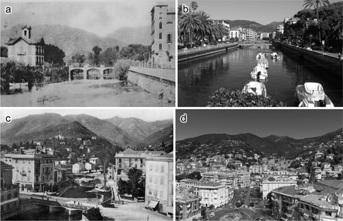
In particular, the final stretch of the Boate Stream was diverted at the end of the eighteenth century to allow the construction of the road to Santa Margherita Ligure, the town located 2 km South-East of Rapallo. The ‘Annibale’ Bridge, under which the aforementioned important road currently runs, is an evidence of the previous path of the riverbed. Moreover, the riverbed experienced narrowing and channelization along the entire plain reach, from the motorway exit to the stream mouth, after the disastrous flood occurred in September 1915 ((a,b)).
Figure 2. Comparison between the Boate (a and b) and San Francesco (c and d) riverbeds at the beginning of the twentieth century (a) and in the 1920s (c), respectively, and at the present day (b and d).
An important left-bank tributary, the Cereghetta Stream, flows into the Boate at the sports ground, completely culverted in its urban stretch. Other significant diversions and culverts were carried out between 1929 and 1931 as documented in the area of the golf course, especially along the final stretch of the Santa Maria Stream.
A similar condition is observed in other two watercourses located in the eastern sector of the Rapallo plain: the San Francesco Stream and the Tuia Stream. They were both narrowed, channelized and culverted ((c,d)).
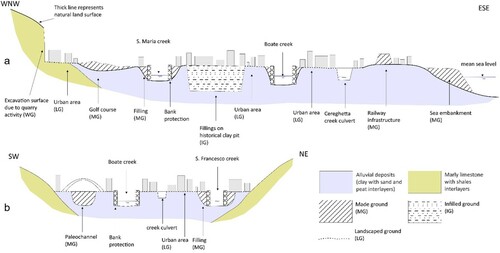
Concerning the plain and its adjacent areas, the urban sprawl substantially has obliterated the former landforms, shaping a new topographic surface that is schematically described in .
Figure 3. Representative, schematic and not to scale geomorphological cross-sections of the Rapallo floodplain showing the main landforms and deposits due to anthropogenic modifications existing along the Boate Valley (a) and along the coastline (b).
Anthropogenic landforms were mapped according to CitationRosenbaum et al. (2003) and CitationCampobasso et al. (2018) in the following four classes.
Made ground: areas where artificial materials have been deposited on the former natural ground topographic surface. The most significant mapped landforms are the embankments at the seaside; the railway line (in the old city, second half of the nineteenth century) and the motorway (in the hinterland, second half of the twentieth century); the fills of valleys, built even for the construction of the cemeteries; the entire golf course area.
Worked ground: areas where the ground is known to have been artificially cut-away (excavated). Significant examples belonging to this category are some recent marly limestone quarries along the lower course of the S. Francesco Stream; the clay quarries in the Sant'Anna district, subsequently covered by the urbanization of the 1960s; the railway tunnels that cross the city.
Infilled ground: areas where the ground has been cut away (excavated) and then an artificial ground (fill) has been deposited. Among this category of complex modifications, we can describe the historic clay quarries of Sant'Anna. In this case, the ground was first excavated for clay mining (brick factory) and then filled with anthropogenic deposits. In particular, firstly (i) large pits to extract the clay were dug. Subsequently, (ii) ponds formed due to groundwater interception, and finally (iii) they were filled with the rubble of buildings damaged during the Second World War bombardments.
Landscaped ground: Areas where the original ground surface has been extensively remodeled, but where it is impractical or impossible to distinguish areas of worked (excavated) ground and made ground. In this category, we would like to highlight both the terraced slopes made by dry stone walls (carried out in historical times) that surround the plain and the entire Rapallo urban area. In some areas of the alluvial-coastal plain that area characterized by soft clays and local presence of peat in the subsoil, the construction of buildings triggered consolidation processes and resulted in consequent partial structural failures of the overlying buildings themselves.
4.2 Floods and sea storms in Rapallo city
The Rapallo territory experienced many intense meteo-hydrological events over time, with ground effects that have often resulted in serious damage to buildings and infrastructure, and sometimes loss of human life ( and ).
Figure 4. Flooded areas of the Rapallo old town during the 1911 (a), 1915 (b), 1961 (c) and 1995 (d) events.
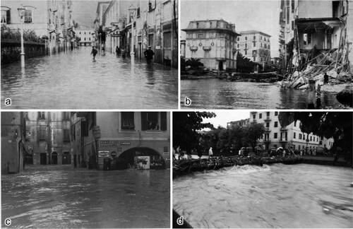
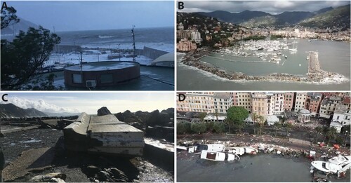
Figure 5. Effects of the 29th October 2018 sea storm surge on the waterfront of Rapallo: (a) The breakwater destruction at the beginning (5:00 pm on the 29th October 2018); (b) destruction of the whole port breakwater (30th October); (c) example of a breakwater segment totally toppled by wave action; (d) the sea promenade damaged and covered by debris and wreckages of beached boats.
shows the main floods and sea storms from the nineteenth century to the present day.
Table 1. Main meteo-hydrological events occurred in Rapallo since the beginning of the nineteenth century.
The Rapallo plain stretch located between the Sant'Anna hamlet and the historic city center was recursively subject to flooding. In particular, on 23–24th October 1911, a disastrous flood of Boate Stream happened, causing serious damage ((a) and (a)).
Figure 6. Water levels recorded during the main historical and recent floods in the Rapallo city.
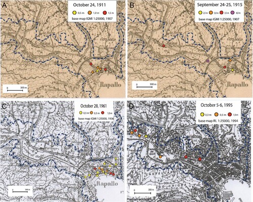
The most disastrous flood event based on historical record took place on 25th September 1915, when a rainfall higher than 400 mm in four hours caused a severe flood of the Boate Stream. In the plain between Sant'Anna and the city center water levels higer than 3 m were recorded and resulted in the destruction of facilities and infrastructure and 16 victims ((b) and (b)).
Another severe flood occurred on 28th October 1961, when the rainfall maximum intensity overcome the value of 250 mm in four hours, causing the San Francesco Stream flood and the inundation of the historic city center ((c) and (c)).
The last severe event involving the Boate Stream occurred on 5-6th October 1995, with a flood peak registered at around 1:30 pm on 6th October. The floods of the Santa Maria and San Pietro streams in the upper part of the plain, and of the Boate in its lower part resulted in water heights up to 1 m in the urban area and damages estimated at over 10 million euro, in current value ((d) and (d)).
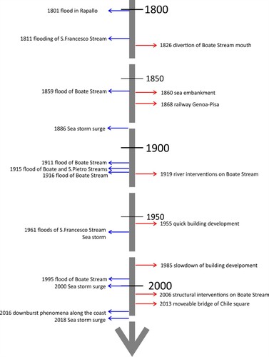
The sequence of flood events and of human interventions are compared in , that highlights a significant correlation between the most relevant anthropogenic modifications (impact) and/or mitigation measures (effectiveness), and the occurrence of floods. The first severe channelization of the Boate Stream was carried out in 1919, after the 1915 catastrophic flood. Furthermore, a series of interventions that were the demolition of an old inadequate bridge, the reconstruction of a new movable bridge, the lowering of the riverbed, and the increase of levees heights, were performed between 2006 and 2013 as a response to the 1995 extreme flood, in order to effectively mitigate the geo-hydrological hazard in the urban area.
Figure 7. Timeline showing the comparison between flood events and human interventions that occurred since the beginning of the nineteenth century.
Among the historical storms that affected the coastline of Rapallo, it is worth mentioning the event occurred on 3th January 1961, when the ship Locarno (145 m long and almost 4000 GRT) ran aground on the coastline embankment, because of a heavy storm sustained by Libeccio wind.
On 14th October 2016, due to the transit of hot and humid currents from the south-east to the eastern part of the Ligurian Sea, a convective structure was generated in the Tigullio Gulf and a phenomenon interpreted as a downburst was triggered with wind gusts up to 120 km/h because of the intense baric gradient. These hurricane-level winds caused significant ground effects with damage to buildings and infrastructure.
The last significant event occurred on 29th October 2018 when Liguria region was hit by a weather front that triggered a baric minimum generating hurricane wind (). On the western Tigullio Gulf the wind blew from the southern quadrants with speed up to 180 km/h. The storm surge caused serious damage along the coast between Rapallo and Portofino, with the partial collapse of Rapallo and Santa Margherita harbors’ breakwater.
The 29th October 2018 event can be considered similar to the one occurred on 6th November 2000, for both the ground effects along the coastline and the identical configuration they had, that consisted of the dominance of long flows from Libeccio in the preliminary phase of the event, and from Scirocco/Mezzogiorno in the paroxysmal one.
In Rapallo, the public and tourist ports were seriously damaged; hundreds of boats sank, the seafront promenade was strongly damaged and the western part of the old town was inundated by the seawater, highlighting a high vulnerability of the waterfront (CitationGallino et al., 2016; CitationVairo et al., 2017).
5. Conclusions
Archival researches, cartographic and photographic multi-temporal comparisons, stratigraphic data analysis and direct observations in the city permitted the identification and mapping of the anthropogenic landforms that characterize the alluvial-coastal plain of Rapallo. The study allowed to obtain the information to reconstruct the geomorphological evolution of this territory under the sign of the Anthropocene (after CitationBrown et al., 2017; CitationCooper et al., 2018).
The city of Rapallo is internationally known for its historical and cultural values and for the birth of tourism on the Ligurian Riviera, in the nineteenth and twentieth centuries. This kind of tourism was originally intended exclusively for the social elite thanks even, and above all, to the mild climate and the charming Ligurian coastal landscape. Since the 1960s, the Rapallo plain experienced deep modifications due to the impact of mass tourism related to the change in national socio-economic conditions. It is above all in this second phase that, in little more than ten years, an irrational and intense urban sprawl occurred. This urbanization process became a famous example of urban development and was named with the ‘rapallizzazione’ neologism.
This study stressed the increasing of geo-hydrological risk due to the highly-impacting human intervention carried out between the late nineteenth and early twentieth century (e.g. diversion, channelization, narrowing and culvert of all the riverbeds), and mainly to the fast and intense urban sprawl induced by tourism activities between 1955 and 1985 (CitationAcquaotta et al., 2019). In this light, a number of interventions aimed to improve the flow capacity and increase the bankfull discharge through the riverbed cross-section enlargement and the obstacles removal were recently carried out along the Boate Stream and are currently in progress along the San Francesco Stream, in order to mitigate the geo-hydrological hazard in the urban area.
The anthropogenic landforms mapping in a highly modified landscape, as the Rapallo plain and coastal area are, was an opportunity for applying both the recently implemented legend of the geomorphological map of Italy (CitationCampobasso et al., 2018) and the classification system of anthropogenic landforms adopted by the British Geological Survey (CitationRosenbaum et al., 2003). These classifications have been already applied in a number of Italian cases, such as Rome, Genoa, Naples and Palermo (CitationBrandolini et al., 2019). A large-scale map of anthropogenic landforms, as the one presented in this paper, requires the integration of both legends: the English one allows to classify artificial ground in macro-categories, while the Italian one allows to represent in detail the single landform, whether it’s excavation or accumulation. Finally, every single case study inevitably requires the development of new legend entries on the base of the urban history that characterizes each ancient city, for both the anthropogenic and the modified natural landforms.
The characterization of the urban geomorphological features required an integrated and multidisciplinary approach including morphological observations in the city, photo-interpretation, geotechnical investigations, archival researches and literature analysis (CitationLuberti et al., 2015).
The implemented method can contribute to improve the national and international approach aimed to analyze the geomorphological features of the urban landscape in riverine and coastal cities of the Mediterranean areas.
In conclusion, this research proposes a novel interpretation of the geomorphological features of the Rapallo plain that are, thus, the result of the impact of human interventions on pristine landforms and geomorphological processes. Moreover, the mapped anthropogenic landforms are currently widely known to be both the elements exposed to natural hazards and the anthropogenic forcing that causes serious ground effects. The large-scale map of the anthropogenic landforms represents a relevant and useful tool for land and urban planning, including the implementation of strategies and measures for the mitigation of geo-hydrological hazard and risk.
Software
The map design and the analysis and processing of data were entirely carried out in a GIS environment by means of the free and open source software QGIS.
Main Map.pdf
Download PDF (22.8 MB)Acknowledgements
The authors thank the reviewers Bieke Cattoor, Alessandro Fontana, Chandra Jayasuriya, and Alessia Pica, and the Editor-in-chief Mike Smith, for their constructive and useful comments that substantially improved this paper and the related map.
Disclosure statement
No potential conflict of interest was reported by the authors.
References
- Acquaotta, F., Faccini, F., Fratianni, S., Paliaga, G., & Sacchini, A. (2018). Rainfall intensity in the Genoa Metropolitan area: Secular variations and consequences. Weather, 73(11), 356–362. https://doi.org/10.1002/wea.3208
- Acquaotta, F., Faccini, F., Fratianni, S., Paliaga, G., Sacchini, A., & Vilìmek, V. (2019). Increased flash flooding in Genoa Metropolitan area: A combination of climate changes and soil consumption? Meteorology and Atmospheric Physics, 131(4), 1099–1110. https://doi.org/10.1007/s00703-018-0623-4
- APAT, Regione Liguria. (2008). Foglio 213230 ‘Genova’ della Carta Geologica d'Italia alla scala 1:50.000 [sheet n. 213230 ‘Genova’ of the Italian Geological Map at 1:250.000 scale]. Selca Editore, Firenze. http://www.isprambiente.gov.it/Media/carg/213_GENOVA/Foglio.html
- ARPAL. (2018). Rapporto di evento meteoidrologico del 27-30/10/2018.
- Autorità di Bacino Regionale. (2017). Piano di Bacino Stralcio per l’assetto Idrogeologico, Ambito 14, Basin Master Plan for the Geo-hydrological risk reduction. http://www.pianidibacino.ambienteinliguria.it/GE/ambito14/ambito14.html
- AVI database. Gruppo Nazionale per la Difesa dalle Catastrofi Idrogeologiche. http://avi.gndci.cnr.it/page.htm
- Ballardini, D. (1994). In burgo Rapalli. Documenti e monumenti di un borgo medievale (In Rapallo village. Documents and monuments of a medieval city). Ecig.
- Barni, G. (1983). Storia di Rapallo e della gente del Tigullio. Ed De Ferrari, Genova.
- Bathrellos, G.D. (2007). An overview in urban geology and urban geomorphology. Bulletin of the Geological Society of Greece, 40(3), 1354–1364. https://doi.org/10.12681/bgsg.16888
- Berri, P. (1979). Rapallo nei secoli. Rievocazioni e scorribande. Ed. Ipotesi, Rapallo.
- Bollati, I. M., Pellegrini, L., Rinaldi, M., Duci, G., & Pelfini, M. (2014). Reach-scale morphological adjustments and stages of channel evolution: The case of the Trebbia River (northern Italy). Geomorphology, 221, 176–186. https://doi.org/10.1016/j.geomorph.2014.06.007
- Brancucci, G., & Paliaga, G. (2005). Geomorphic characterization of the main drainage basins of maritime Liguria (Italy) - preliminary results. Geografia Fisica e Dinamica Quaternaria, suppl. VII, 59–67.
- Brandolini, P. (1994). Le trasformazioni della piana costiera di Rapallo (Liguria Orientale) dal 1700 ad oggi: Rapporti fra condizioni morfologiche ed interventi dell’uomo (The Rapallo coastal floodplain changes from 1700 to nowadays: Relationships between morphology and human interventions). In F. Citarella (Ed.), Studi Geografici in onore di Domenico Rocco (pp. 27–40). Loffredo editore.
- Brandolini, P. (2017a). The outstanding terraced landscape of the Cinque Terre coastal slopes (eastern Liguria). In M. Soldati & M. Marchetti (Eds.), Landscapes and landforms of Italy, World geomorphological Landscapes (pp. 235–244). Springer International Publishing.
- Brandolini, P., Cappadonia, C., Luberti, G. M., Donadio, C., Stamatopoulos, L., Di Maggio, C., Faccini, F., Stanislao, C., Vergari, F., Paliaga, G., Agnesi, V., Alevizos, G., & Del Monte, M. (2019). Geomorphology of the Anthropocene in Mediterranean urban areas. Progress in Physical Geography: Earth and Environment, 1–34. https://doi.org/10.1177/0309133319881108
- Brandolini, P., Faccini, F., Paliaga, G., & Piana, P. (2017b). Urban geomorphology in coastal environment: Man made morphological changes in a seaside tourist resort (Rapallo, eastern Liguria, Italy). Quaestiones Geographicae, 36(3), 97–110. https://doi.org/10.1515/quageo-2017-0027
- Brandolini, P., Faccini, F., Paliaga, G., & Piana, P. (2018a). Man-made landforms identification and mapping in an highly urbanized historical centre on coastal-hilly Mediterranean environment. Geogr. Fis. Din. Quat, 41(1), 23–34. https://doi.org/10.4461/GFDQ.2018.41.2
- Brandolini, P., Faccini, F., Robbiano, A., & Terranova, R. (2007). Geomorphological hazard and monitoring activity in the western rocky coast of the Portofino Promontory (Italy). Quaternary International, 171-172, 131–142. https://doi.org/10.1016/j.quaint.2006.11.006
- Brandolini, P., Faccini, F., Robbiano, A., & Terranova, R. (2008). Relationship between flood hazards and geomorphology applied to land planning in the upper Aveto Valley (Liguria, Italy). Geografia Fisica e Dinamica Quaternaria, 31, 73–82.
- Brandolini, P., Pepe, G., Capolongo, D., Cappadonia, C., Cevasco, A., Conoscenti, C., Marsico, A., Vergari, F., & Del Monte, M. (2018). Hillslope degradation in representative Italian areas: Just soil erosion risk or opportunity of development? Land Degradation & Development, 29(9), 3050–3068. https://doi.org/10.1002/ldr.2999%A0 doi: 10.1002/ldr.2999
- Brown, A. G., Tooth, S., Bullard, J. E., Thomas, D. S. G., Chiverrell, R. C., Plater, A. J., Murton, J., Thorndycraft, V. R., Tarolli, P., Rose, J., Wainwright, J., Downs, P., & Aalto, R. (2017). The geomorphology of the Anthropocene: Emergence, status and implications. Earth Surface Processes and Landforms, 42(1), 71–90. https://doi.org/10.1002/esp.3943
- Cafiso, F., & Cappadonia, C. (2019). Landslide inventory and rockfall risk assessment of a strategic urban area (Palermo, Sicily). Rendiconti Online Della Società Geologica Italiana, 48, 96–105. https://doi.org/10.3301/ROL.2019.42
- Campobasso, C., Carton, A., Chelli, A., D’Orefice, M., Dramis, F., Graciotti, R., Guida, D., Pambianchi, G., Peduto, F., & Pellegrini, L. (2018). Aggiornamento ed integrazioni delle Linee guida della Carta geomorfologica d’Italia alla scala 1:50.000. Progetto CARG: modifiche ed integrazioni al Quaderno n. 4/1994. Quaderni serie III 13(1).
- Cappadonia, C., Coratza, P., Agnesi, V., & Soldati, M. (2018). Malta and Sicily joined by geoheritage enhancement and geotourism within the framework of land management and development. Geosciences, 8(7), 253. https://doi.org/10.3390/geosciences8070253
- Cencetti, C., De Rosa, P., & Fredduzzi, A. (2017). Geoinformatics in morphological study of River Paglia, Tiber River basin, Central Italy. Environmental Earth Sciences, 76(3), 128. https://doi.org/10.1007/s12665-017-6448-5
- Cimmino, F., Faccini, F., & Robbiano, A. (2004). Stones and coloured marbles of Liguria in historical monuments. Per. Mineral, 73, 71–84. (Special Issue 3: a showcase of the Italian research in applied petrology).
- Città Metropolitana di Genova. (2015). Piano di Bacino Ambito 15, piano stralcio per la tutela dal rischio idrogeologico di cui all’art. 1, comma 1 del D.L. n. 180/1998 convertito in Legge n. 267/1998 e s.m.i. Available at: http://www.pianidibacino.ambienteinliguria.it/GE/ambito15/ambito15.html
- Comune di Rapallo. (2014). Studi Geologici a supporto del Piano Urbanistico Comunale. Progetto definitivo.
- Cooke, R. U., Brunsden, D., Doornkamp, J. C., & Jones, D. K. C. (1982). Urban geomorphology in drylands. Oxford University Press.
- Cooper, A. H., Brown, T. J., Price, S. J., Ford, J. R., & Waters, C. N. (2018). Humans are the most significant global geomorphological driving force of the 21st century. The Anthropocene Review, 5(3), 222–229. https://doi.org/10.1177/2053019618800234
- Cortemiglia, G. C., & Terranova, R. (1974). Aspetti geomorfologici, idrologici ed oceanografici del Golfo di Rapallo (Geomorphogical, hydrological and oceanographic aspects of the Gulf of Rapallo). Atti Soc. It. Sc. Nat, 285–384.
- Crutzen, P. J. (2002). Geology of mankind. Nature, 415(6867), 23. https://doi.org/10.1038/415023a
- Del Monte, M., D’Orefice, M., Luberti, G. M., Marini, R., Pica, A., & Vergari, F. (2016). Geomorphological classification of urban landscapes: The case study of Rome (Italy). Journal of Maps, 12(sup1), 178–189. https://doi.org/10.1080/17445647.2016.1187977
- Del Monte, M., Vergari, F., Brandolini, P., Capolongo, D., Cevasco, A., Ciccacci, S., Conoscenti, C., Fredi, P., Melelli, L., Rotigliano, E., Zucca, F. (2015). Multi-method evaluation of denudation rates in small Mediterranean catchments. In G. Lollino, A. Manconi, & J. Clague (Eds.), Engineering Geology for Society and territory, climate change and Engineering Geology (Vol. 1, pp. 563–567). Springer International Publishing.
- Diao, C. (1996). An approach to theory and methods of urban geomorphology. Chinese Geographical Science, 6(1), 88–95. https://doi.org/10.1007/s11769-996-0039-9
- Donadio, C. (2017). Experimenting criteria for risk mitiga- tion in fluvial-coastal environment. CSE Journal – City Safety Energy, 1, 9–14.
- Ellison, R. A., Booth, S. L., & Strange, P. J. (1993). Geological mapping in urban areas. Episodes, 16(3), 383–388. https://doi.org/10.18814/epiiugs/1993/v16i3/003
- Eyles, N. (1997). Environmental geology of urban areas. Geological Association of Canada. Geotext 3.
- Faccini, F., Luino, F., Paliaga, G., Sacchini, A., & Turconi, L. (2015). Yet another disaster flood of the Bisagno stream in Genoa (Liguria, Italy): October the 9th-10th 2014 event. Rendiconti Online Della Società Geologica Italiana, 35, 128–131. https://doi.org/10.3301/ROL.2015.81
- Faccini, F., Luino, F., Paliaga, G., Sacchini, A., Turconi, L., & de Jong, C. (2018). Role of rainfall intensity and urban sprawl in the 2014 flash flood in Genoa city, Bisagno catchment (Liguria, Italy). Applied Geography, 98, 224–241. https://doi.org/10.1016/j.apgeog.2018.07.022 doi: 10.1016/j.apgeog.2018.07.022
- Faccini, F., Paliaga, G., Piana, P., Sacchini, A., & Watkins, C. (2016). The Bisagno stream catchment (Genoa, Italy) and its major floods (1822, 1970 and 2014): geomorphic and land use variations in the last three centuries. Geomorphology, 273, 14–27. https://doi.org/10.1016/j.geomorph.2016.07.037
- Faccini, F., Piccazzo, M., Robbiano, A., & Roccati, A. (2008). Applied geomorphological Map of the Portofino municipal territory (Italy). Journal of Maps, 4(1), 451–462. https://doi.org/10.4113/jom.2008.1023 doi: 10.4113/jom.2008.1023
- Federici, B., Corradi, N., Ferrando, I., Sguerso, D., Lucarelli, A., Guida, S., & Brandolini, P. (2019). Remote sensing techniques applied to geomorphological mapping of rocky coast: The case study of Gallinara Island (western Liguria, Italy). European Journal of Remote Sensing, 52(sup4), 123–136. https://doi.org/10.1080/22797254.2019.1686957
- Gallino, S., Benedetti, A., & Onorato, L. (2016). Wave Watching. Lo spettacolo delle mareggiate in Liguria. Ed Hoepli, Milano (2° ed.).
- Galve, J., Cevasco, A., Brandolini, P., Piacentini, D., Azañón, J. M., Notti, D., & Soldati, M. (2016). Cost-based analysis of mitigation measures for shallow-landslide risk reduction strategies. Engineering Geology, 213, 142–157. https://doi.org/10.1016/j.enggeo.2016.09.002 doi: 10.1016/j.enggeo.2016.09.002
- Goudie, A. (2018). The human impact in geomorphology – 50 years of change. Geomorphology. Epub ahead of print 8 December 2018. https://doi.org/10.1016/j.geomorph.2018.12.002
- Huggenberger, P., & Epting, J. (2011). Urban geology. Process-oriented concept for Adaptive and integrated Resource Management. Springer.
- Jefferson, A. J., Wegmann, K. W., & Chin, A. (2013). Geomorphology of the Anthropocene: Understanding the surficial legacy of past and present human activities. Anthropocene, 2(2), 1–3. https://doi.org/10.1016/j.ancene.2013.10.005
- Lóczy, D., & Süto, L. (2011). Human activity and geomorphology. In The Sage Handbook of geomorphology (260–278). London: Sage Publications.
- Luberti, G. M. (2018). Computation of modern anthropogenic-deposit thicknesses in urban areas: A case study in Rome, Italy. The Anthropocene Review, 5(1), 2–27. https://doi.org/10.1177/2053019618757252
- Luberti, G. M., Prestininzi, A., & Esposito, C. (2015). Development of a geological model useful for the study of the natural hazards in urban environments: An example from the eastern sector of Rome (Italy). Italian Journal of Engineering Geology and Environment, 2, 41–62. https://doi.org/10.4408/IJEGE.2015-02.O-04
- Luberti, G. M., Vergari, F., Pica, A., & Del Monte, M. (2019). Estimation of the thickness of anthropogenic deposits in historical urban centres: An interdisciplinary methodology applied to Rome (Italy). The Holocene, 29(1), 158–172. https://doi.org/10.1177/0959683618804630
- Luino, F., Nigrelli, G., Turconi, L., Faccini, F., Agnese, C., & Casillo, F. (2016). A proper land-use planning through theuse of historical research. Disaster Advances, 9(1), 819.
- Luino, F., Paliaga, G., Roccati, A., Sacchini, A., Turconi, L., & Faccini, F. (2019). Anthropogenic changes in the alluvial plains of the Tyrrhenian Ligurian basin. Rendiconti Online Della Società Geologica Italiana, 48, 10–16. https://doi.org/10.3301/ROL.2019.31
- Mandarino, A., Maerker, M., & Firpo, M. (2019a). Channel planform changes along the Scrivia River floodplain reach in northwest Italy from 1878 to 2016. Quaternary Research, 91(2), 620–637. https://doi.org/10.1017/qua.2018.67
- Mandarino, A., Maerker, M., & Firpo, M. (2019b). ‘The stolen space’: A history of channelization, reduction of riverine areas and related management issues. The lower Scrivia river case study (NW Italy). International Journal of Sustainable Development and Planning, 14(2), 118–129. https://doi.org/10.2495/SDP-V14-N2-118-129
- Mandarino, A., Pepe, G., Maerker, M., Cevasco, A., & Brandolini, P. (2020). Short-term GIS analysis for the Assessment of the recent Active-channel Planform Adjustments in a Widening, highly Altered River: The Scrivia River, Italy. Water, 12(514), 1–22. https://doi.org/10.3390/w12020514
- Marini, M. (1981). Analisi geologica-strutturale ed interpretazione paleogeografica e tettogenetica dei Calcari del Monte Antola (Appennino Ligure). Ofioliti, 6(1), 119–150.
- Mastronuzzi, G., Aringoli, D., Aucelli, P.P.C., Baldassarre, M.A., Bellotti, P., Bini, M., Biolchi, S., Bontempi, S., Brandolini, P., Chelli, A., Davoli, L., Deiana, G., De Muro, S., Devoto, S., Di Paola, G., Donadio, C., Fago, P., Ferrari, M., Furlani, S., … Valente, A. (2017). Geomorphological map of the Italian coast: From a descriptive to a morphodynamic approach. Geografia Fisica e Dinamica Quaternaria, 40, 161–196, https://doi.org/10.4461/GFDQ2017.40.11. IT ISSN 0391-9838.
- Min. LL. PP. (1954). Annali idrologici. Servizio Idrografico, Sezione Autonoma del Genio Civile con sede in Genova per i bacini con foce al litorale tirrenico dal Roia al Magra. Istituto Poligrafico dello Stato.
- Min. LL. PP. (1960). Annali idrologici. Servizio Idrografico, Sezione Autonoma del Genio Civile con sede in Genova per i bacini con foce al litorale tirrenico dal Roia al Magra. Istituto Poligrafico dello Stato.
- Min. LL. PP. (1962). Annali idrologici. Servizio Idrografico, Sezione Autonoma del Genio Civile con sede in Genova per i bacini con foce al litorale tirrenico dal Roia al Magra. Istituto Poligrafico dello Stato.
- Molli, G., Crispini, L., Malusà, M., Mosca, P., Piana, F., & Federico, L. (2010). Geology of the northern Apennine–western Alps junction area: A regional review. In M. Beltrando, A. Peccerillo, M. Mattei, S. Conticelli, & C. Doglioni (Eds.), The Geology of Italy: Tectonics and life along Plate Margins (Vol. 36, Paper 9). Journal of the Virtual Explorer. https://doi.org/10.3809/jvirtex.2009.00215
- Paliaga, G. (2015). Erosion triangular facets as markers of order in an open dissipative system. Pure and Applied Geophysics, 172(7), 1985–1997. https://doi.org/10.1007/s00024-014-0937-1
- Paliaga, G., Giostrella, P., & Faccini, F. (2016). Terraced landscape as cultural and environmental heritage at risk: An example from Portofino Park (Italy). Annales, Ser. Hist. Sociol, 26(3), 513–522. https://doi.org/10.19233/ASHS.2016.32
- Paliaga, G., Luino, F., Turconi, L., De Graff, J. V., & Faccini, F. (2020). Terraced landscapes on Portofino Promontory (Italy): identification, geo-hydrological hazard and management. Water, 12(1), 435. https://doi.org/10.3390/w12020435
- Paliaga, G., Luino, F., Turconi, L., & Faccini, F. (2019). Inventory of geo-hydrological phenomena in Genova municipality (NW Italy). Journal of Maps, 15(2), 28–37. https://doi.org/10.1080/17445647.2018.1535454
- Pepe, G., Mandarino, A., Raso, E., Cevasco, A., Firpo, M., & Casagli, N. (2019a). Extreme flood and landslides triggered in the Arroscia Valley (Liguria Region, Northwestern Italy) during the November 2016 rainfall event. In Slope Stability: Case Histories, Landslide Mapping, Emerging Technologies, Proceedings of the IAEG/AEG Annual Meeting Proceedings, San Francisco, CA, USA, 17–21 September 2018; Shakoor, A., Kato, K. (Eds.); Springer International Publishing: Cham, Switzerland; 1, 171-175.
- Pepe, G., Mandarino, A., Raso, E., Scarpellini, P., Brandolini, P., & Cevasco, A. (2019b). Investigation on farmland abandonment of terraced slopes using multitemporal data sources comparison and its implication on hydro-geomorphological processes. Water, 11(8), 1552. https://doi.org/10.3390/w11081552
- Pica, A., Vergari, F., Fredi, P., & Del Monte, M. (2016). The aeterna urbs geomorphological heritage (Rome, Italy). Geoheritage, 8(1), 31–42. https://doi.org/10.1007/s12371-015-0150-3
- Raso, E., Mandarino, A., Pepe, G., Di Martire, D., Cevasco, A., Calcaterra, D., & Firpo, M. (2019). Landslide Inventory of the Cinque Terre National Park, Italy. In Slope Stability: Case Histories, Landslide Mapping, Emerging Technologies, Proceedings of the IAEG/AEG Annual Meeting Proceedings, San Francisco, CA, USA, 17–21 September 2018; Shakoor, A., Kato, K. (Eds.); Springer International Publishing: Cham, Switzerland; 1, 201–205.
- Reynard, E., Pica, A., & Coratza, P. (2017). Urban geomorphological heritage: An overview. Quaestiones Geographicae, 36(3), 7–20. https://doi.org/10.1515/quageo-2017-0022
- Roccati, A., Faccini, F., Luino, F., De Graff, J., & Turconi, L. (2019). Morphological changes and human impact in the Entella River floodplain (Northern Italy) from the 17th century. Catena, 182, 104122. https://doi.org/10.1016/j.catena.2019.104122
- Rodrigues, M. L., Machado, C. R., & Freire, E. (2011). Geotourism routes in urban areas: A preliminary approach to the Lisbon geoheritage survey. GeoJournal of Tourism and Geosites, 8(2), 281–294.
- Rosenbaum, M. S., McMillan, A. A., Powel, J. H., Cooper, A. H., Culshaw, M. G., & Northmore, K. J. (2003). Classification of artificial (man-made) ground. Engineering Geology, 69(3). https://doi.org/10.1016/S0013-7952(02)00282-X
- Sacchini, A., Ferraris, F., Faccini, F., & Firpo, M. (2012). Environmental climatic maps of Liguria. Journal of Maps, 8(3), 199–207. https://doi.org/10.1080/17445647.2012.703901
- Scarin, F. (1959). Rapallo, nota di Geografia Urbana. Annali di Ricerche e Studi di Geografia, 189-214.
- Scorpio, V., Aucelli, P. P. C., Giano, S. I., Pisano, L., Robustelli, G., Rosskopf, C. M., & Schiattarella, M. (2015). River channel adjustments in southern Italy over the past 150 years and implications for channel recovery. Geomorphology, 251, 77–90. https://doi.org/10.1016/j.geomorph.2015.07.008
- Slaymaker, O., Spencer, T., & Embleton-Hamann, C. H. (2009). Geomorphology and Global Environmental change, 450. Cambridge University Press.
- Steffen, W., Crutzen, P. J., & McNeill, J. R. (2007). The Anthropocene: Are humans now overwhelming the great forces of nature? AMBIO: A Journal of the Human Environment, 36(8), 614–621. https://doi.org/10.1579/0044-7447(2007)36[614:TAAHNO]2.0.CO;2
- Surian, N., Rinaldi, M., Pellegrini, L., Audisio, C., Maraga, F., Teruggi, L., Turitto, O., & Ziliani, L. (2009). Channel adjustments in northern and central Italy over the last 200 years. In L. A. James, S. L. Rathburn, & G. R. Whittecar (Eds.), Management and Restoration of fluvial Systems with Broad historical changes and human Impacts (pp. 83–95). Geological Society of America Special Papers. Geological Society of America.
- Tarquini, S., Isola, I., Favalli, M., Mazzarini, F., Bisson, M., Pareschi, M. T., & Boschi, E. (2007). TINITALY/01: A new triangular Irregular network of Italy. Annals of Geophysics, 50, 407–425. https://doi.org/10.4401/ag-4424
- Tarquini, S., Vinci, S., Favalli, M., Doumaz, F., Fornaciai, A., & Nannipieri, L. (2012). Release of a 10-m-resolution DEM for the Italian territory: Comparison with global-coverage DEMs and anaglyph-mode exploration via the web. Computers & Geosciences, 38(1), 168–170. https://doi.org/10.1016/j.cageo.2011.04.018
- Vairo, T., Quagliati, M., Del Giudice, T., Barbucci, A., & Fabiano, B. (2017). From land-to water-use-planning: A consequence based case-study related to cruise ship risk. Safety Science, 97, 120–133. https://doi.org/10.1016/j.ssci.2016.03.024
- Waters, C. N., Zalasiewicz, J. A., Summerhayes, C., Barnosky, A. D., Poirier, C., Gałuszka, A., Cearreta, A., Edgeworth, M., Ellis, E. C., Ellis, M., Jeandel, C., Leinfelder R., McNeill J. R., Richter D. D., Steffen W., Syvitski J., Vidas D., Wagreich M., Williams M. … Wolfe A. P. (2016). The Anthropocene is functionally and stratigraphically distinct from the Holocene. Science, 351(6269), aad2622. https://doi.org/10.1126/science.aad2622
- Zwoliński, Z., Hildebrandt-Radke, I., Mazurek, M., & Makohonienko, M. (2017). Existing and proposed urban geosites values resulting from geodiversity of Poznań city. Quaestiones Geographicae, 36(3), 125–149. https://doi.org/10.1515/quageo-2017-0031